|
Description : |
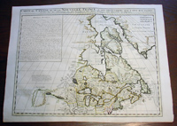
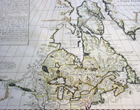
This
large
beautifully
hand coloured original antique & important early map of
The Great Lakes, Canada &
the Upper Mid-West
- with descriptive French text to the right of the map -
was published by
Henri
Abraham
Chatelain in 1719, in
his famous
Atlas Historique.
Background: Nice
example of Chatelain's edition of De L'Isle's seminal
map of Canada, the Great Lakes and Upper Midwest, first
issued in 1703.
Chatelain's map of Canada & the Great Lakes was the
first printed map to locate Detroit, first issued only 2
years after the founding of the Village by Cadillac. De
L'Isle studied at the French Maritime Ministry from 1700
to 1703, during which time he took extensive notes on
the work of the Jesuit Missionaries, including
Franquelin, Jolliet and others. Karpinksi note that the
fruits of De L'Isle's substantial efforts are born out
by the great improvements in the mapping of the 5 Great
Lakes and other parts of the map.
The map is one of the most important maps of Canada
printed during its time, and was included in Chatelain's
Atlas Historique. Numerous trading posts and
missions in New France and the major towns of the
adjacent British colonies are shown. The area around
Hudson's Bay is inhabited by native tribes referred to
as the "Christinaux or Kilistinons," while Labrador is
home to the "Eskimaux."
The map features a number of notes specifically
referring to the names of explorers and the dates in
which they discovered certain places, such as the
reference to 'Nouveau Danemarc', discovered by the
Danish explorer Jan Munk in 1619. The depiction of the
upper Mississippi and Ohio basins is also quite
detailed, noting the French fort of 'St. Louis' or 'Crevecouer'
near the present-day site of Peoria, Illinois. Perhaps
the most fascinating aspect of the map is its portrayal
of the "Riviere Longue," one of the most sensational and
enduring cartographic misconceptions ever devised. This
mythical river was reported to flow from the 'Pays des
Gnacsitares' in the far west, promising the best route
through the interior of the continent, supposedly
placing one within close reach of the Pacific Ocean. It
is a product of the imagination of the Baron Lahontan, a
French adventurer, whose best-selling travel narrative
Nouveaux voyages dans l'Amérique septentrionale
(1703) convinced many of the world's greatest intellects
of the existence of this mythical waterway. The text,
'Remarque Historique' that fills the northwestern part
of the map describes the history of New France from the
days of Jacques Cartier to contemporary times.
Henri Abraham Chatelain
(1684 - 1743)
was a Huguenot pastor of Parisian origins. He lived
consecutively in Paris, St. Martins, London (c. 1710),
the Hague (c. 1721) and Amsterdam (c. 1728).
Chatelain was a skilled artist and knew combining a
wealth of historical and geographical information with
delicate engraving and an uncomplicated composition.
Groundbreaking for its time, this work included studies
of geography, history, ethnology, heraldry, and
cosmography. His maps with his elegant engraving are a
superb example from the golden age of French
mapmaking.The publishing firm of Chatelain, Chatelain
Frères and Chatelain & Fils is recorded in Amsterdam,
from around 1700-1770, with Zacharias living "op den
Dam" in 1730.
Henri Abraham Chatelain, his father Zacharie Chatelain
(d.1723) and Zacharie Junior (1690-1754), worked as a
partnership publishing the Atlas Historique, Ou Nouvelle
Introduction à L'Histoire under several different
Chatelain imprints, depending on the Chatelain family
partnerships at the time of publication. The atlas was
published in seven volumes between 1705 and 1720, with a
second edition appearing in 1732. The volumes I-IV with
a Third edition and volume I with a final edition in
1739.
Henri Abraham Chatelain, whose "Atlas Historique" was
one of the most expansive Dutch encyclopedias of the
age. First published in 1705, Chatelain's Atlas
Historique was part of an immense seven-volume
encyclopedia. Although the main focus of the text was
geography, the work also included a wealth of
historical, political, and genealogical information. The
text was compiled by Nicholas Gueudeville and Garillon
with a supplement by H.P. de Limiers and the maps were
engraved by Chatelain, primarily after charts by De
L'Isle. The atlas was published in Amsterdam between
1705 and 1721 and was later reissued by Zacharie
Chatelain between 1732 and 1739.
Atlas Historique:
First published in Amsterdam from 1705 to 1720, the
various volumes were updated at various times up to 1739
when the fourth edition of vol.I appeared, stated as the
"dernière edition, corrigée & augmentée."
The first four volumes seem to have undergone four
printings with the later printings being the most
desirable as they contain the maximum number of
corrections and additions. The remaining three final
volumes were first issued between 1719-1720 and revised
in 1732.
An ambitious and beautifully-presented work, the Atlas
Historique was intended for the general public,
fascinated in the early eighteenth century by the
recently conquered colonies and the new discoveries.
Distant countries, such as the Americas, Africa, the
Middle East, Mongolia, China, Japan, Indonesia, etc.,
take an important place in this work.
In addition to the maps, many of which are based on
Guillaume De L'Isle, the plates are after the best
travel accounts of the period, such as those of Dapper,
Chardin, de Bruyn, Le Hay and other.
Other sections deal with the history of the european
countries, and covers a wide range of subjects including
genealogy, history, cosmography, topography, heraldry
and chronology, costume of the world, all illustrated
with numerous engraved maps, plates of local inhabitants
and heraldic charts of the lineages of the ruling
families of the time. The maps, prints and tables
required to make up a complete set are listed in detail
in each volume.
The accompanying text is in French and often is printed
in two columns on the page with maps and other
illustrations interspersed. Each map and table is
numbered consecutively within its volume and all maps
bear the privileges of the States of Holland and West-Friesland.
The encyclopaedic nature of the work as a whole is
reflected in this six frontispiece. The pages are the
work of the celerated mr. Romeijn de Hooghe. and are
engraved by J.Goeree, T.Schynyoet and P.Sluyter.
New scholarship has suggested the compiler of the atlas,
who is identified on the title as "Mr. C***" not to be
Henri Abraham Châtelain, but Zacharie Châtelain. (See
Van Waning's article in the Journal of the International
Map Collectors' Society for persuasive evidence of the
latter's authorship.)
(Ref: M&B; Tooley)
General Description:
Paper thickness and quality: - Heavy and stable
Paper color: - White
Age of map color: - Early
Colors used: - Pink, green, yellow, blue
General color appearance: - Authentic
Paper size: - 23 1/4in x 17 1/2in (590m x 445m)
Plate size: - 20 3/4in x 16 1/4in (530m x 410mm)
Margins: - min. 1/2in (12mm)
Imperfections:
Margins: - None
Plate area: - Folds as issued
Verso: - None
If you wish to discuss this or any other item
please email or call...Simon
61 (0) 409 551910 Tel
simon@classicalimages.com
|
|