Search the entire catalogue by entering a key search term in the ‘search’ box or browse our stock by selecting from the list of categories below.
MAPS AUSTRALIA/PACIFIC
![]()
AUSTRALIA
![]()
|
|||||||||||||
|
Cartographer : | Louis Freycinet | |||||||||||
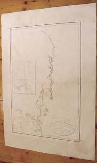
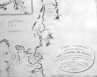
| Title : | Carte Generale de la Cote Orientale de la Terre de Diemen...1802 | ||||||||||||
| Date : | 1802 (1812) | ||||||||||||
| Size : | 38in x 26in (965mm x 600mm) | ||||||||||||
| Description : |
This large beautifully engraved
early & important original antique map of the east
coast of Tasmania as surveyed by the Baudin expedition
in 1802 -
The map contains 3 inset maps two of which shows early cartographic details of Van Diemens land by Abel Tasman in 1642 & the English explorer Tobias Furneaux in 1773. The third inset is a map of part of the North River surveyed by Freycinet in 1802. After returning from the first expedition on Le Naturaliste and Le Geographe Louis Freycinet returned to Australia on La Casuarina and aided by Boullanger explored Northern Tasmania and the southern coast of Australia. This and earlier voyages resulted in the publication of Voyage de descouvertes aux Terres Australes in 1812.
Louis Claude Desaulces
de Freycinet (1779-1842) was a French marine officer and
explorer, who participated in several significant early
19th-century expeditions to relatively unknown areas in
the southern hemisphere. In 1800, he joined one of the
most important early explorations of Australia, which
was commissioned by the French government and commanded
by Nicholas Baudin (1754-1803). On this voyage, which
included stops in Mauritius and Tasmania, Freycinet
served as a surveyor and was responsible for conducting
a thorough cartographic survey of the Australian coast.
Upon returning to France years later, he completed a
detailed account of the journey begun by the naturalist
Françis Péron that was published as Voyage de
decouvertes aux Terres Australes between 1807 and
1816.
General
Description: |
||||||||||||
| Condition : | (A+) Fine Condition | ||||||||||||
| Price :
Ref. No. : |
|||||||||||||
|
|||||||||||||