|
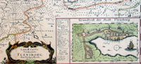
This
large fine beautifully hand coloured original antique map of
central region of Schleswig-Holstein - centering on the
city of Flensburg, wit an inset view of the city itself - was created by the famous
cartographer Johann Mejer. These maps were in turn engraved
by
Matthias and Nicolai Petersen of Husum in the early 17th
century
and eventually published in the 1659 Spanish edition of
Joan Blaeu's Nuevo Atlas.
These maps of the Schleswig-Holstein & Danish
regions are scarce, incredibly beautiful and detailed
making them some of the best regional maps produced in
the 17th century. Originally drawn by the very talented
Johann Mejer a proposed atlas of these regions, by
Mejer, in the early 17th century never eventuated.
In 1658 the plates were acquired by Joan Blaeu.
Unfortunately Blaeu only managed to publish this series
of maps in 5 volumes of Atlas Major & Novus - between
1659 & 1672 - before the plates were destroyed in the
disastrous fire that wiped out the Blaeu publishing firm
in 1672.
The
Schleswig-Holstein
& Danish
maps were engraved by the brothers Matthias and Nicolai
Petersen, both goldsmiths in the town of Husum,
after drawings by the highly talented cartographer
Johannes Mejer, also a citizen of Husum.
Mejer
was famous for his cartographic genius as can be seen in
his workmanship. A monumental atlas of Denmark proposed
by Mejer was never fulfilled due to the disastrous wars
between Denmark and Sweden 1657-60.
In the 1650s, the area of Schleswig and Holstein was
split into regions either ruled by the Danish king or by
his kinsman, the duke of Schleswig-Holstein-Gottorp. The
maps by Mejer were a result of a united sponsorship of
the Danish king Frederik III and his political
counterpart, duke Friedrich III of Holstein-Gottorp. The
latter used all his political energy to loosen his
dukedom from the Danish realm by nurturing close
relations to Sweden.
Thanks to this coordinated initiative the most detailed
and accurate description of the area between the Baltic
and the North Sea was achieved at a level far ahead of
the time.
The maps also give an important documentation of the
development of the coastline along the North Sea. A
flood in 1634 changed it totally, swallowing both
islands and towns, but Mejer has been able to produce
credible maps of the area both before and after this
disaster. The cartouches show all kinds of peasants,
fishermen and town people, fulfilling the aspirations of
this atlas to give at total description of this part of
Europe as it was in the year of 1652.
These maps are a credit to Mejer & the Blaeu firm, beautifully
engraved with immense detail.
The original hand
colouring is also a credit to Blaeu who spared no
expense using the best colours available even using Gold
to highlight the decoration of his maps.
(Ref:
Koeman; Tooley; M&B)
General Description:
Paper thickness and quality: - Heavy and stable
Paper color: - White
Age of map color: - Original
Colors used: - Yellow, pink, red, blue, green
General color appearance: - Authentic
Paper size: - 23 1/2in x 17 1/2in (600mm x 445mm)
Plate size: - 23 1/2in x 17 1/2in (600mm x 445mm)
Margins: - Min 1/2in (12mm)
Imperfections:
Margins: - Bottom margin & border cropped into image,
light age toning
Plate area: - None
Verso: - Soiling
|