Search the entire catalogue by entering a key search term in the ‘search’ box or browse our stock by selecting from the list of categories below.
MAPS WESTERN EUROPE
![]()
FRANCE
![]()
|
|||||||||||||
|
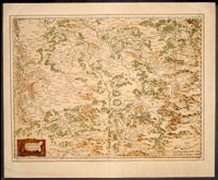
Cartographer : | Henricus Hondius | |||||||||||
| Title : | Lorraine Vers Le Midy | ||||||||||||
| Date : | 1638 | ||||||||||||
| Size : | 21 1/2in x 17 1/2in (545mm x 445mm) | ||||||||||||
| Description : |
This
beautifully hand coloured original antique map
of the South Lorraine region of France - centering on
the Moselle River with the city of Nancy to the north Faucogney-et-la-Mer
to the south & the Meuse River to the west - by Gerard
Mercator was published by Joducus
Hondius in the 1638 edition of Mercators Atlas.
Condition Report:
Imperfections: |
||||||||||||
| Condition : | (A+) Fine Condition | ||||||||||||
| Price :
Ref. No. : |
|||||||||||||
|
|||||||||||||