Search the entire catalogue by entering a key search term in the ‘search’ box or browse our stock by selecting from the list of categories below.
MAPS EAST EUROPE/RUSSIA
![]()
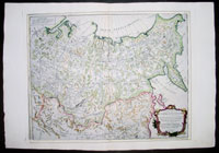
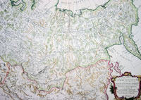
RUSSIA
![]()
|
|||||||||||||
|
Cartographer : | Robert De Vaugondy | |||||||||||
| Title : | Partie Orientale DE L Empire De Russie en Asie...Sr. Robert De Vaugondy...Par P Santini | ||||||||||||
| Date : | 1776 | ||||||||||||
| Size : | 30 1/2in x 21in (775mm x 535mm) | ||||||||||||
| Description : |
This large beautifully
engraved hand coloured original antique map of Eastern
Russia, Northern China & Mongolia by Robert De Vaugondy and was published by P Santini (fl. 1776-84)
in his 2 volume edition of Atlas Universal in 1776.
General Description: | ||||||||||||