Search the entire catalogue by entering a key search term in the ‘search’ box or browse our stock by selecting from the list of categories below.
MAPS AUSTRALIA/PACIFIC
![]()
NEW GUINEA
![]()
|
|||||||||||||
|
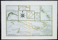
Cartographer : | Rigobert Bonne | |||||||||||
| Title : | Carte des Decouvertes du Capt,. Carteret dans La Nlle. Bretagne..Par M Bonne | ||||||||||||
| Date : | 1780 | ||||||||||||
| Size : | 16in x 11in (405mm x 2805mm) | ||||||||||||
| Description : |
This beautifully hand coloured original antique map of New Guinea, New Ireland, and 5 other small inset maps of various Bays of the Philippines & other Pacific Islands was published in 1780 edition of Atllas des toutes les parties connues du globe terrestre by Rigobert Bonne & Guillaume Raynal. This detailed map shows parts of the island of Nouvelle Guinea - Papua New Guinea - and Nle. Bretagne - New Britain - which is the largest island in the Bismarck Archipelago northeast of New Guinea. The map features the sea-tracks of the voyages of explorers including Capt. Carteret's voyage of 1766-1769 aboard the HMS Swallow and the voyage of William Dampier who named New Britain in 1700. Capt. James Cook's route on his first Pacific voyage from New Holland to Batavia via the Endeavour Straits [i.e. Torres Straits] in 1770 is also shown. (Ref Tooley M&B). General Description: Imperfections: |
||||||||||||
| Condition : | (A+) Fine Condition | ||||||||||||
| Price :
Ref. No. : |
|||||||||||||
|
|||||||||||||