Search the entire catalogue by entering a key search term in the ‘search’ box or browse our stock by selecting from the list of categories below.
MAPS BRITISH ISLES
![]()
![]()
|
|||||||||||||
|
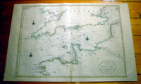
Cartographer : | Alexis Hubert Jaillot | |||||||||||
| Title : | Carte De La Manche faite par ordre du Roy..a Paris...1692 | ||||||||||||
| Date : | 1692 | ||||||||||||
| Size : | 38in x 25in (960mm x 635mm) | ||||||||||||
| Description : |
This very large, beautifully
hand coloured original 1st edition antique map of
English Channel - or La Manche as it is known in French
- by
Alexis Hubert Jaillot,
after
Nicolas Sanson - was engraved in 1692 - the date is
engraved in the title - and was published in the 1693
edition of
Le Neptune Francois.
General Description: Imperfections: |
||||||||||||
| Condition : | (A+) Fine Condition | ||||||||||||
| Price :
Ref. No. : |
|||||||||||||
|
|||||||||||||