Search the entire catalogue by entering a key search term in the ‘search’ box or browse our stock by selecting from the list of categories below.
MAPS AMERICA
![]()
CANADA
![]()
|
|||||||||||||
|
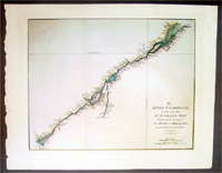
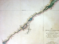
Cartographer : | John Harrison | |||||||||||
| Title : | The River St. Lawrence, Accurately Drawn from d'Anville's Map, Published .... | ||||||||||||
| Date : | 1780 | ||||||||||||
| Size : | 21in x 16 1/2in (535mm x 420mm) | ||||||||||||
| Description : |
This large beautifully engraved
hand coloured original antique map of the St Lawrence
River, Canada was
published by John Harrison in 1780.
In 1535 two Indian youths told Jacques Cartier about the
route to "Kanata." They were referring to the village of
Stadacona; Kanata was simply the Huron-Iroquois word for
village or settlement. This modest, generic name stuck.
Cartier used "Canada" to refer to the entire area
subject to its chief, Donnacona. The name was soon
applied to a much larger area: maps in 1547 designated
everything north of the St. Lawrence River as "Canada."
Cartier also called The St. Lawrence River the "Riviere
de Canada," a name used until the early 1600s. By 1616,
although the entire region was formally known as New
France, the area along the great river was still called
Canada.
General Description:
Imperfections: |
||||||||||||
| Condition : | (A+) Fine Condition | ||||||||||||
| Price :
Ref. No. : |
|||||||||||||
|
|||||||||||||