Search the entire catalogue by entering a key search term in the ‘search’ box or browse our stock by selecting from the list of categories below.
MAPS MIDDLE EAST
![]()
HOLY LAND
![]()
|
|||||||||||||
|
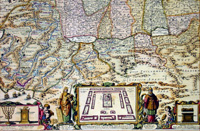
Cartographer : | Nicolas Visscher | |||||||||||
| Title : | Viertzig Iarige Reysen Der Kinder Israel Aus Egypten Durch Das Rote-Meer Und Wusten Biss Ins Gelobte | ||||||||||||
| Date : | 1660 | ||||||||||||
| Size : | 19 ½in x 15in (500mm x 385mm) | ||||||||||||
| Description : |
This beautifully hand coloured original antique map of the Holy land showing the ancients lands of the Tribes of Israel, from Egypt to Syria - depicting amongst other things the flight of Moses and the Israelites from Egypt - by Nicolas Visscher was published in ca 1660. This antique map with German text on the verso is oriented with north to the east. Encompassing the Promised Land and Egypt it traces the flight of the Children of Israel out of Egypt, their wandering through the desert and their route to the Land of Canaan (Exodus). Moses is depicted on Mount Sinai receiving the Ten Commandments. Along the bottom of the map are a number of illustrations (from left to right) are two sides of a shekel coin, Menorah & temple vessels, Moses and Aaron on either side of the Tabernacle surrounded by the twelve tribes of Israel and finally a depiction of the Ark of the Covenant. Also included is a fine title cartouche, ships sailing in both the Mediterranean and Red Seas and a charming scene of Jonas and the whale (Ref: Tooley; M&B; Nebenzahl ) General Description: |
||||||||||||
| Condition : | (A) Very Good Condition | ||||||||||||
| Price :
Ref. No. : |
|||||||||||||
|
|||||||||||||