Search the entire catalogue by entering a key search term in the ‘search’ box or browse our stock by selecting from the list of categories below.
MAPS WESTERN EUROPE
![]()
SPAIN
![]()
|
|||||||||||||
|
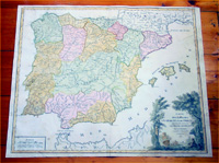
Cartographer : | Robert De Vaugondy | |||||||||||
| Title : | Carte Des Royaumes D Espange et de Portugal...1757 | ||||||||||||
| Date : | 1757 | ||||||||||||
| Size : | 23 1/2in x 19 1/2in (600mm x 495mm) | ||||||||||||
| Description : |
p>This large beautifully
hand coloured original antique map of Spain & Portugal
was published by Robert Du Vaugondy
in his 1757 - dated - edition of Atlas Universal, Paris. General Description:
Imperfections: |
||||||||||||
| Condition : | (B) Good Condition | ||||||||||||
| Price :
Ref. No. : |
|||||||||||||
|
|||||||||||||