Search the entire catalogue by entering a key search term in the ‘search’ box or browse our stock by selecting from the list of categories below.
MAPS ASIA
![]()
INDIA
![]()
|
||||||||||
|
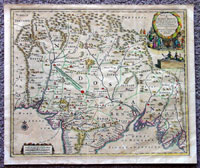
Cartographer : | Pieter Vander AA | ||||||||
| Title : | Royaume du Grand Mogol...Pierre Vander AA | |||||||||
| Date : | 1720 | |||||||||
| Size : | 15in x 12 1/4in (370mm x 310mm) | |||||||||
| Description : |
This beautifully hand coloured
original
antique map of
Northern India, the Mogul Empire, was published by Peter
Vander AA in 1720.
General Description:
Imperfections:
If you wish to discuss this or any other item |
|||||||||
| Condition : | (A) Very Good Condition | |||||||||
| Price :
Ref. No. : |
||||||||||
|
||||||||||