Search the entire catalogue by entering a key search term in the ‘search’ box or browse our stock by selecting from the list of categories below.
MAPS WESTERN EUROPE
![]()
SPAIN
![]()
|
|||||||||||||
|
Cartographer : | J B Homann | |||||||||||
| Title : | Carte nouvelle de l'Isle de Cadix & du Detroit de Gibraltar | ||||||||||||
| Date : | 1730 | ||||||||||||
| Size : | 24 1/2in x 21in (620mm x 530mm) | ||||||||||||
| Description : |
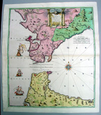
This large beautifully hand coloured extremely attractive original antique map of the Strait of Gibraltar, Cadiz & southern Spain and Morocco, North Africa was published by Johann Baptiste Homann in 1730.
This map of the Strait of Gibraltar was a
collaborative effort between Jean de Petit (royal
engineer and architect), Johann Friedrich Weidler
(mathematician and astronomer at Witenberg), R.A.
Schneider (engraver) and Johann Baptist Homann
(publisher).
General
Description:
Imperfections:
If you wish to discuss this or any other item |
||||||||||||
| Condition : | (A+) Fine Condition | ||||||||||||
| Price :
Ref. No. : |
|||||||||||||
|
|||||||||||||