|
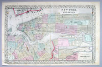
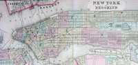
This large
two page beautifully hand coloured original antique map
of New York City & Brooklyn- with inset map of NYC north
of Central Park to 155th St. - was engraved in 1867 -
dated at the foot of the map - and was published by Samuel Augustus
Mitchell in his large New General Atlas.
These county, state, city & country maps are some of the
most ornate and beautifully coloured maps published in
the US in the 19th century. For over 50 years, Mitchell
his son's and their successors were the most prominent
cartographical publishers of maps and atlases in the
United States.
Samuel Augustus Mitchell was born in Bristol,
Connecticut on March 20, 1792. His father emigrated from
Scotland in 1773. While little is know about his early
schooling, it is know that Mitchell found the quality of
early geography text books to be lacking, and determined
that he would write and publish better works. This
decision led him to relocate to Philadelphia in 1829 or
1830, which was then the center of commercial publishing
in America.
Mitchells first cartographic work was the re-issue of
Anthony Finleys New American Atlas in 1831, a work first
issued by Finley in 1826, in response to Henry Schenk
Tanners monumental work of the same title, issued in
serial format from 1818 to 1822 and as a complete work
from 1823 onward. While the map content in Mitchells
edition of the New American Atlas are same as Finleys
edition, each map has been significantly improved and
revised, primarily with the addition of new owns and
roads. This is especially true in the South and West.
Finley had originally collaborated with D.H. Vance and
J.H. Young in the preparation of the maps. Vances name
is removed from the Mitchell edition. Mitchell continued
to work with Young, an association which would continue
for several decades.
Following publication of the New American Atlas,
Mitchell began issuing the individual maps in pocket map
format. Beginning in 1834, Mitchell began offering
reduced sized Tourist Pocket Maps of a number of states
in the United States. J.H. Young and D. Haines are
listed as the engravers on these maps. In 1832, Mitchell
offered the first edition of his Travellers Guide
Through the United States, A Map of the Roads,
Distances, Steam Boat & Canal Routes &c. By J.H. Young .
. ., which would become one of his most popular and
enduring works. The map of the United States was done by
steel engraving, one of the earliest uses of a steel
engraving in map publishing in America. In the same
year, the first edition of Mitchells Map of the United
States, by J.H. Young was issued, bearing the copyright
date of October10, 1831. This map would be revised and
issued until 1844. Young also compiled A New Map of the
United States in 1833. These two wall maps would come to
dominate the market and their success led to several
later US wall maps issued by Mitchell. This second map
was also issued under the title of Mitchells Reference
and Distance Map of the United States, which was issued
until 1851.
Beginning in 1839, Mitchell also began publication of
his school atlas. This work and variant editions for
older and younger students, was issued by Mitchell and
his successors from 1839 to 1886.
Mitchell was neither a cartographer nor an engraver. His
primary function was as the editor and business manager
of his publishing company, with Young working as the
primary maker of maps.
In 1845, Mitchell acquired the rights to Henry Schenk
Tanners New Universal Atlas from Carey & Hart, which had
previously acquired the copyright from Tanner and
published editions of 1843 and 1844. Mitchell changed
many of the maps and issued two editions of the atlas in
1846. He changed the copperplates to lithography,
utilizing Peter S. Duval in Philadelphia to produce the
stones. Mitchell re-issued the atlas at least annually
until 1850, when he sold the rights to the work to
Thomas, Cowperthwait & Company, who published the atlas
until 1853, when it in turn sold the rights to the newly
reorganized Cowperthwait, Desilver & Butler. Thereafter,
Desilver took over publication in 1855, revised the
decorative border of the maps, and issued editions until
1859, when the copyright was sold to Cushings & Bailey,
who published editions of the New Universal Atlas in
1859 and 1860. These latter editions are very rare and
incorporate several novel maps, including a
mid-continent map of the US beginning in 1855 and a map
of Kansas in 1859. There has also been reports of an
1862 edition, although this writer is not aware of any
examples in public or private collections.
In 1860, Mitchells son Samuel Augustus Mitchell Jr.
began issuing Mitchells New General Atlas. While his
father had continued to issue wall maps and other works,
this appears to be his sons first entry into the trade.
The New General Atlas was issued by SA Mitchell Jr.
until 1887. From 1880 to 1887, Bradley & Company
published the atlas. Various other minor publishers,
including A.R. Keller, produced editions as late as
1894. (Ref:
M&B; Tooley)
General Description:
Paper thickness and quality: - Heavy and stable
Paper color: - off white
Age of map color: - Original
Colors used: - Yellow, green, red, brown.
General color appearance: - Authentic and fresh
Paper size: - 22 1/2in x 14 1/2in (570mm x 370mm)
Plate size: - 22 1/2in x 14 1/2in (570mm x 370mm)
Margins: - Min ½in (12mm)
Imperfections:
Margins: - Bottom left margin corner restored, not
affecting the image
Plate area: - Light soiling
Verso: - Light soiling, repair to left hand of image, no
loss
If you wish to discuss this or any other item
please email or call - good luck, Simon.
Classical Images
61 (0) 409 551910 Tel
simon@classicalimages.com

Web Counter
|