|
Description : |
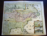
This
large
beautifully
hand coloured original antique map of North America was
published by
Henri
Abraham
Chatelain in 1719, in
his famous
Atlas Historique.
One of the most significant and influential early 18th
century maps of North America published by the French to
promote French settlements within Louisiana, Mississippi
and Canada. The original English US colonial states are
also included from New England to The Carolinas as are
Spanish interests in the west. But what is most
noteworthy is the inclusion of the many American Indian
nations stretching from Canada to Florida and New
Mexico, with many notes and illustrations throughout the
map.
This is a magnificent map with bright hand colouring on
clean strong sturdy paper with original margins and a heavy clear impression.
Pricing: Since 1983 there have been 58 recorded
sales of this map cumulating in a top price of $3700US
in 2010.(Ref: AMPR)
Background: Henri
Chatelain's map of the inhabited parts of North America
is based upon Nicholas De Fer's landmark 4 sheet map
published in 1718. At the top left of the map is large
scale map of the Mississippi Delta and Mobile Bay, based
upon the 1699 voyage of Pierre Le Moyne d'Iberville,
this inset is also included in De Fer's rare 4 sheet
map. D' Ibeville explored the mouth of the Mississippi
and its many tributaries, including the Red River in
Arkansas. Heidenreich and Dahl surmised that that the
the original 4 sheet De Fer map was issued to promoted
the recently established Compagnie Francoise Occident
and reinforce French opinion in the 1713 boundary
settlement. The settlement was initially successful in
promoting French emigration to America. However, the
financing side of the company, conceived by John Law to
help finance the debt left by by Louis XIV, led to a
wild burst of speculation and ultimate collapse. This
episode is often referred to as the Mississippi Bubble.
Chatelain's one sheet version of De Fer's map proved
very successful and was copied
by Van Keulen and Ottens. The map includes a a nice
plan and view of Quebec, and fine detail in the Great
Lakes and Mississippi. The map features vignettes and
notes throughout.
This map was first issued in Volume
6 of Chatelain's 7 volume
Atlas Historique,
published between 1705 and 1720.
Henri Abraham Chatelain
(1684 - 1743)
was a Huguenot pastor of Parisian origins. He lived
consecutively in Paris, St. Martins, London (c. 1710),
the Hague (c. 1721) and Amsterdam (c. 1728).
Chatelain was a skilled artist and knew combining a
wealth of historical and geographical information with
delicate engraving and an uncomplicated composition.
Groundbreaking for its time, this work included studies
of geography, history, ethnology, heraldry, and
cosmography. His maps with his elegant engraving are a
superb example from the golden age of French
mapmaking.The publishing firm of Chatelain, Chatelain
Frères and Chatelain & Fils is recorded in Amsterdam,
from around 1700-1770, with Zacharias living "op den
Dam" in 1730.
Henri Abraham Chatelain, his father Zacharie Chatelain
(d.1723) and Zacharie Junior (1690-1754), worked as a
partnership publishing the Atlas Historique, Ou Nouvelle
Introduction à L'Histoire under several different
Chatelain imprints, depending on the Chatelain family
partnerships at the time of publication. The atlas was
published in seven volumes between 1705 and 1720, with a
second edition appearing in 1732. The volumes I-IV with
a Third edition and volume I with a final edition in
1739.
Henri Abraham Chatelain, whose "Atlas Historique" was
one of the most expansive Dutch encyclopedias of the
age. First published in 1705, Chatelain's Atlas
Historique was part of an immense seven-volume
encyclopedia. Although the main focus of the text was
geography, the work also included a wealth of
historical, political, and genealogical information. The
text was compiled by Nicholas Gueudeville and Garillon
with a supplement by H.P. de Limiers and the maps were
engraved by Chatelain, primarily after charts by De
L'Isle. The atlas was published in Amsterdam between
1705 and 1721 and was later reissued by Zacharie
Chatelain between 1732 and 1739.
Atlas Historique:
First published in Amsterdam from 1705 to 1720, the
various volumes were updated at various times up to 1739
when the fourth edition of vol.I appeared, stated as the
"dernière edition, corrigée & augmentée."
The first four volumes seem to have undergone four
printings with the later printings being the most
desirable as they contain the maximum number of
corrections and additions. The remaining three final
volumes were first issued between 1719-1720 and revised
in 1732.
An ambitious and beautifully-presented work, the Atlas
Historique was intended for the general public,
fascinated in the early eighteenth century by the
recently conquered colonies and the new discoveries.
Distant countries, such as the Americas, Africa, the
Middle East, Mongolia, China, Japan, Indonesia, etc.,
take an important place in this work.
In addition to the maps, many of which are based on
Guillaume De L'Isle, the plates are after the best
travel accounts of the period, such as those of Dapper,
Chardin, de Bruyn, Le Hay and other.
Other sections deal with the history of the european
countries, and covers a wide range of subjects including
genealogy, history, cosmography, topography, heraldry
and chronology, costume of the world, all illustrated
with numerous engraved maps, plates of local inhabitants
and heraldic charts of the lineages of the ruling
families of the time. The maps, prints and tables
required to make up a complete set are listed in detail
in each volume.
The accompanying text is in French and often is printed
in two columns on the page with maps and other
illustrations interspersed. Each map and table is
numbered consecutively within its volume and all maps
bear the privileges of the States of Holland and West-Friesland.
The encyclopaedic nature of the work as a whole is
reflected in this six frontispiece. The pages are the
work of the celerated mr. Romeijn de Hooghe. and are
engraved by J.Goeree, T.Schynyoet and P.Sluyter.
New scholarship has suggested the compiler of the atlas,
who is identified on the title as "Mr. C***" not to be
Henri Abraham Châtelain, but Zacharie Châtelain. (See
Van Waning's article in the Journal of the International
Map Collectors' Society for persuasive evidence of the
latter's authorship.)
(Ref: M&B; Tooley)
General Description:
Paper thickness and quality: - Heavy and stable
Paper color: - White
Age of map color: - Early
Colors used: - Pink, green, yellow, blue
General color appearance: - Authentic
Paper size: - 20 3/4in x 17 1/2in (530m x 445m)
Plate size: - 19 1/2in x 16 1/2in (500m x 425mm)
Margins: - min. 1/8in (3mm)
Imperfections:
Margins: - None
Plate area: - None
Verso: - None
If you wish to discuss this or any other item
please email or call...Simon
61 (0) 409 551910 Tel
simon@classicalimages.com
|
|