|
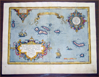
This beautifully
hand coloured original antique map
of the mid Atlantic Azores Islands was published by
Abraham Ortelius in
the 1592 Latin edition of Theatrum Orbis Terrarum.
Ortelius published a total of 4425 of this map between
1584 to 1612.
Background: The map covers the Azores in
considerable detail with numerous ships decorating the
seas and a large sea serpent just west of St. Michael.
The detail and overall beauty of Ortelius' map is
reflective of the importance of the Azores to 16th and
17th century navigators. Columbus stopped, and was
briefly imprisoned, here on his first voyage of
discovery to the Americas. Other navigators followed his
example until the islands became a major resupply point
on the Spanish Galleon routes to and from the New World.
Ortelius derived this map from Luis Teixeira's single
sheet map of Terceira from 1582, which bears Ortelius'
name and of which Meurer mentions one copy at the
Biblioteque Nationale in Paris (Meurer p. 253-254).
This map first appeared in the 1584 Latin edition of the
Theatrum Orbis Terrarum.
Background: For the first time, in
1570, all the elements of the modern Atlas were brought
to publication in Abraham Ortelius' Theatrum Orbis
Terrarum. This substantial undertaking assembled
fifty-three of the best available maps of the world by
the most renowned and up to date geographers.
Unlike earlier compositions, such as the Italian
composite or "Lafreri" Atlases, each of Ortelius' maps
was engraved specifically for his Atlas according to
uniform format. Through its launching, pre-eminence in
map publishing was transferred from Italy to the
Netherlands, leading to over a hundred years of Dutch
supremacy in all facts of cartographical production.
There were a
total of 7300 copies of Theatrum
published between 1570 - 1612 from 31 editions. (Ref: Van Den Broecke; Tooley)
General Description:
Paper thickness and quality: - Light and stable
Paper color: - off white
Age of map color: - Original & early color
Colors used: - Yellow, green, blue, pink
General color appearance: - Authentic
Paper size: - 20 3/4in x 16in (530mm x 410mm)
Plate size: - 18 1/2in x 13in (470mm x 335mm)
Margins: - Min 1in (25mm)
Imperfections:
Margins: - Light soiling & ink smear in margins
Plate area: - Professional restoration along centerfold,
light offsetting top left & right of image
Verso: - Professional restoration along centerfold,
light soiling
If you wish to discuss this or any other item
please email or call...Simon
61 (0) 409 551910 Tel
simon@classicalimages.com
|