|
General Description
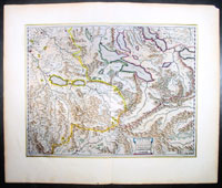
This beautifully engraved and hand
coloured map of
central
Switzerland including Bern, Lucerne and the Alps including the Eger
was published by Joan Blaeu in the 1659 Spanish
edition - there is only one only one Spanish edition of this map -
of Atlas Novus.
By comparison with her larger neighbours,
Germany and Italy, it may not be considered that Switzerland has made a major
contribution to the history of cartography, but in the sixteenth century
especially Swiss influence was by no means negligible. Certainly the first
printed map of Switzerland was published in Martin Waldseemuller's edition of
Ptolemy at Strasbourg in 1513, but the manuscript map by Konrad Turst (1497)
drawn to scale was a splendid achievement for its time and the researches of
Vadianus at St Gallen University produced notable work; the Germanic influence
in Basle, which became part of the Swiss Confederation in 1501, and the highly
developed wood engraving skills there were important factors in European map
publishing. The almost endless editions of Munster were published there from
1540 onwards for nearly a century and Zurich can claim to have published the
first national atlas produced anywhere -that of Johann Stumpf in 1548-52.
In the second half of the sixteenth century many maps of the cantons in
manuscript or woodcut appeared but the mountainous nature of the country
produced its own mapping problems and imposed a need for large-scale surveys as
well as practical and effective methods of showing land surfaces in relief.
Early in the seventeenth century Hans Gyger perfected new ways of doing this but
although he published a wide range of very large-scale maps of the cantons and
of Switzerland as a whole his techniques did not receive the acceptance they
deserved. On the other hand his countrymen followed his precedent of compiling
large-scale maps for which they have always been noted until the present day.
(M&B 1998)
Condition Report:
Paper thickness and quality: - Heavy and stable
Paper color: - White
Age of map color: - Later
Colors used: - Pink, yellow, green
General color appearance: - Authentic
Paper Size: - 24in x 20in (610mm x 510mm)
Plate size: - 20in x 15 1/2in (508mm x 395mm)
Margins: - Min 2in (50mm)
Imperfections:
Margins: - None
Plate area: - None
Verso: - None
|