Search the entire catalogue by entering a key search term in the ‘search’ box or browse our stock by selecting from the list of categories below.
MAPS WESTERN EUROPE
![]()
FRANCE
![]()
|
|||||||||||||
|
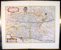
Cartographer : | Henricus Hondius | |||||||||||
| Title : | Lionnois Forest et Beauiolois | ||||||||||||
| Date : | 1636 | ||||||||||||
| Size : | 23in x 19in (585mm x 485mm) | ||||||||||||
| Description : |
This fin The text running for two pages on the back
of the map generally describes the region or country name, history (as it was),
temperature, seasons, soil and agricultural productivity. Also described is the
topography, wildlife, local inhabitants their culture and religion, as well as a
description of major European and local towns and cities. This text makes
extremely enjoyable reading and a very good insight not only into the area
described but the general European attitudes towards alien countries and
cultures.
Condition Report: |
||||||||||||
| Condition : | (A+) Fine Condition | ||||||||||||
| Price :
Ref. No. : |
|||||||||||||
|
|||||||||||||