Search the entire catalogue by entering a key search term in the ‘search’ box or browse our stock by selecting from the list of categories below.
MAPS AUSTRALIA/PACIFIC
![]()
NEW ZEALAND
![]()
|
|||||||||||||
|
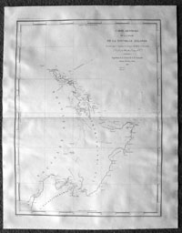
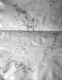
Cartographer : | Jules Sébastien César Dumont D'Urville | |||||||||||
| Title : | Carte Generale de la Partie De La Nouvelle Zelande...D'Urville...1827 | ||||||||||||
| Date : | 1827 | ||||||||||||
| Size : | 26in x 20in (660mm x 510mm) | ||||||||||||
| Description : |
This
large finely engraved original
antique map of the North Island of New Zealand
was engraved
in 1827 - dated - and was published
in the 1833 edition of
Dumont
d'Urville
Voyage de la corvette l'Astrolabe.
Jules
Sébastien César Dumont d'Urville
(17901842) - was born
on 23 May 1790 at Condé-sur-Noireau, a village in
Normandy, France. His father was Gabriel François
Dumont, sieur of Urville and an hereditary
Judge; his mother, née Jeanne de Croisilles,
was of a noble French family.
| ||||||||||||