|
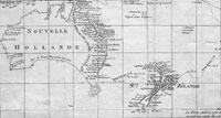
A fine example of this very large and important original antique map,
a chart of Australia and New Zealand tracking the voyage
of by
Lieutenant James Cook during
his first voyage of
discovery between 1768 & 1771. This map was published in the 1st French
version of John Hawkesworth's voyages in 1774.
The map was engraved
by the eminent French engraver Robert Benard,
responsible for many of the prints and maps of the
French period of enlightenment during the 18th century.
During his first voyage of 1768-71 on the
Endeavour,
he charted New Zealand and the eastern coast of
Australia. This map follows the voyages of Cook and
other explorers of the South Pacific Ocean between 1765
- 1769. The routes of Byron,
Mouats,
Wallis, Carteret, and Cook are depicted, with
indications of the dates of their travels and their
discoveries. A notation on the map indicates that the
shaded coastlines are the new discoveries of these
explorers. The south-eastern tip of Australia is still
connected to Tasmania, and the inland area is blank as
it was still largely unexplored.
Cook was recognized by his contemporaries as a highly
competent navigator and scientific observer. The map
clearly details his departure from the more established
routes crossing the Pacific at a higher latitude, making
it inevitable that he reached New Holland's east coast.
Note the more northerly route taken by Cooks
predecessors through calmer waters, thus missing the
prize of the east coast of Australia.
Cook's First Voyage
(1768-1771)
The first voyage under
Captain James Cook's command was primarily of a
scientific nature. The expedition on the Endeavour
initially sailed to Tahiti to observe the transit of the
planet Venus in order to calculate the earth's distance
from the sun. Cook landed on the South Pacific island in
April of 1769 and in June of that year the astronomical
observations were successfully completed. In addition to
these labors, very good relations with the Tahitians
were maintained and the naturalists Joseph Banks and
Daniel C. Solander conducted extensive ethnological and
botanical research.
Another purpose of the voyage was to explore the South
Seas to determine if an inhabitable continent existed in
the mid-latitudes of the Southern Hemisphere. Upon
leaving Tahiti, Cook named and charted the Society
Islands and then continued southwest to New Zealand. His
circumnavigation and exploration of that country also
resulted in a detailed survey. Cook proceeded to
Australia, where he charted the eastern coast for 2,000
miles, naming the area New South Wales. As a result of
these surveys, both Australia and New Zealand were
annexed by Great Britain. In addition to these
explorations, the Endeavour returned to England
without a single death from scurvy among its men, an
historic feat at the time. The combination of these
accomplishments brought Cook prominence, promotion, and
the opportunity to lead further expeditions.
(Ref Tooley; M&B; Clancy)
General Description:
Paper
thickness and quality: - Heavy and stable
Paper color: - White
Age of map color: -
Colors used: -
General color appearance: -
Paper size: - 28in x 16 3/4in (710mm x 425mm)
Plate size: - 26 3/4in x 14 3/4in (680mm x 375mm)
Margins: - 1/2in (12mm)
Imperfections:
Margins: - Bottom half right margin extended from just outside
border
Plate area: - Folds as issued, light creasing
Verso: - None
If you wish to discuss this or any other item
please email or call - good luck, Simon.
Classical Images
61 (0) 409 551910 Tel
simon@classicalimages.com 
Web Counter
|