Search the entire catalogue by entering a key search term in the ‘search’ box or browse our stock by selecting from the list of categories below.
MAPS AMERICA
![]()
![]()
|
|||||||||||||
|
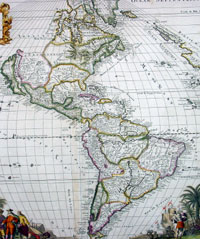
Cartographer : | Gerald Valck | |||||||||||
| Title : | L'Amerique Septentrionale & Meridionale divisee en ses principales parties . . . | ||||||||||||
| Date : | 1700 | ||||||||||||
| Size : | 24in x 20in (610mm x 510mm) | ||||||||||||
| Description : |
This
large and scarce beautifully
hand coloured original antique map of America, depicting
California as an Island, was published by Gerard Valck
in
ca
1700.
Background:
Valck's map of America illustrates many of the myths of
cartographic America in the 17th Century. California is
shown as an island based on the second Sanson Model. A
massive land bridge extends from just west of Capo
Blanco on the northern California coastline to Niphon, a
curious adaptation of the legend of Compagnie Land
(shown here as a place name -- Terre de la Compagne) and
the continuous land bridge from America to Asia,
although adding the Detroit de Tzungaar (Strait of
Tzungaar), a very rarely mentioned mythical Strait
between two islands of Japan. Many of the facts of America depicted in this map Valk derives directly from Alexis-Hubert Jaillot in the late 17th century. Interestingly in transferring FLORIDE FRANÇOISE from Jaillot the engraver managed to come up with Floroi de Fran. It appears the remainder of Françoise was erased whilst arranging the border. No attempt is made to update the cartography, none of the more recent English colonies is present, not even Pennsylvania, arguably the one with the most exposure throughout the continent of Europe. A second title is engraved across the top of the map detailing further the various territories. The imprint and a total of eight different scales are decorated by a trading scene with natives who appear more Asian than American Indian. It is more accurately rendered in the similar scene lower right. (Ref: Burden; Tooley; M&B) General Description: Imperfections:
If you wish to discuss this or any other item |
||||||||||||
| Condition : | (B) Good Condition | ||||||||||||
| Price :
Ref. No. : |
|||||||||||||
|
|||||||||||||