Search the entire catalogue by entering a key search term in the ‘search’ box or browse our stock by selecting from the list of categories below.
MAPS WESTERN EUROPE
![]()
ITALY
![]()
|
|||||||||||||
|
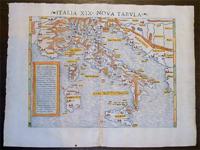
Cartographer : | Sebastian Munster | |||||||||||
| Title : | Italia XIX Nova Tabula | ||||||||||||
| Date : | 1545 | ||||||||||||
| Size : | 17in x 13in (430mm x 330mm) | ||||||||||||
| Description : |
This fine
beautifully hand coloured original antique map of
modern contemporary Italy in the mid 16th century was published by
Sebastian Munster in the 1545 edition of
Ptolemy's Geographia, with 54 maps based on text by
the Greek Mathematician Claude Ptolemy.
Geographia: contained a
total of 54 woodcut maps, first published in 1540 and
re-issued until 1552.
Munsters
"contemporary" maps were a result of data sent to him by
German and European scholars of description of the
villages, towns trades etc in their regions. The
response was so great that over a 12 year period Munster
was able to compile the first of many up-to-date, if not
accurate, maps in both his two major publications,
Geographia and Cosmographia. The result was one of
the first comprehensive cartographical publications of
regions of Europe and other parts of the world. Also as
was the case with many cartographical publications of
the time ancient maps interpreted from the text of the
scholar Ptolemy were included along side the "modern"
ones.
Claude Ptolemy: a
Greek mathematician, astronomer and geographer, living
in Alexandria, assembled and codified his predecessors'
cartographic theories including those of Strabo &
Marinus of Tyre (c. AD 120) to whom he was
especially indebted. In about AD 150 he published his
Geographia, a work in 8 volumes, supposedly
illustrated with a world map, 26 regional maps and a
profusion of smaller maps. Although the text of the
Geographia survived, no maps older than about the
twelfth century have come down to us and, in
consequence, we have no means of knowing whether the
'Ptolemy' maps on which we set so much store were, in
fact, drawn by him or were the interpretations of later
map makers using his text as a basis.
Sebastian Münster
(1488-1552) was a German cartographer, cosmographer, and
Hebrew scholar whose work Cosmographia (1544;
"Cosmography") was the earliest German description of
the world and a major work in the revival of geographic
thought in 16th-century Europe.
It had numerous editions in different languages
including Latin, French, Italian, English, and even
Czech.
Altogether, about 40 editions of the Cosmographia
appeared between 1544 and 1628 and
was one of the most successful and popular books of the
16th century.
Münster was a major influence in popular thinking in
Europe for the next 200 years.
General Description:
Imperfections:
If you wish to discuss this or any other item |
||||||||||||
| Condition : | (A+) Fine Condition | ||||||||||||
| Price :
Ref. No. : |
|||||||||||||
|
|||||||||||||