Search the entire catalogue by entering a key search term in the ‘search’ box or browse our stock by selecting from the list of categories below.
MAPS EAST EUROPE/RUSSIA
![]()
![]()
|
|||||||||||||
|
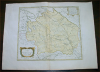
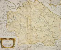
Cartographer : | Nicolas Sanson | |||||||||||
| Title : | Sarmatia Utraque Europaea et Asiatica...1741 | ||||||||||||
| Date : | 1741 | ||||||||||||
| Size : | 27in x 20 1/4in (690mm x 515mm) | ||||||||||||
| Description : |
This large beautifully engraved hand coloured original
antique map of the ancient region of Sarmatia -
stretching from Finland, Poland, Russia, Ukraine to central Asia - was
engraved by
Pierre Mariette
in 1649 - the date is engraved in the dedication
cartouche - and was published by Nicholas Sanson in his
atlas Cartes Generales de Toutes les Parties du
Monde.
General
Description:
Imperfections:
If you wish to discuss this or any other item |
||||||||||||
| Condition : | (A+) Fine Condition | ||||||||||||
| Price :
Ref. No. : |
|||||||||||||
|
|||||||||||||