Search the entire catalogue by entering a key search term in the ‘search’ box or browse our stock by selecting from the list of categories below.
MAPS WEST INDIES/CARIBBEAN
![]()
CARIBBEAN
![]()
|
||||||||||
|
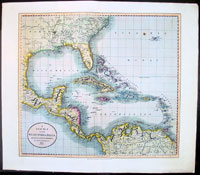
Cartographer : | John Cary | ||||||||
| Title : | A New Map of The West India Isles...1803 | |||||||||
| Date : | 1803 | |||||||||
| Size : | 24 1/2in x 21 1/2in (620mm x 550mm) | |||||||||
| Description : |
This large beautifully hand coloured original antique map of the Gulf of Mexico, the Caribbean, Central America and northern South America was engraved by John Cary in 1803 - the date is engraved in the title cartouche - and was published in 1808 for Cary's New Universal Atlas. (Ref Tooley M&B)
General Description:
Imperfections: |
|||||||||
| Condition : | (A+) Fine Condition | |||||||||
| Price :
Ref. No. : |
||||||||||
|
||||||||||