Search the entire catalogue by entering a key search term in the ‘search’ box or browse our stock by selecting from the list of categories below.
MAPS BRITISH ISLES
![]()
ENGLAND
![]()
|
|||||||||||||
|
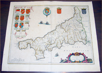
Cartographer : | Jaon Blaeu | |||||||||||
| Title : | Cornubia sive Cornwallia | ||||||||||||
| Date : | 1637 | ||||||||||||
| Size : | 22in x 18 1/2in (560mm x 470mm) | ||||||||||||
| Description : |
This
beautifully hand coloured original antique map of
English county of Cornwall
was published in the 1637 German edition of Joan Blaeu's
Atlas Novus.
Background: Blaeu is one of the most revered map
makers of all time and it is easy to see why in this
beautiful original map.
Condition Report:
Imperfections:
If you wish to discuss this or any other item |
||||||||||||
| Condition : | (A) Very Good Condition | ||||||||||||
| Price :
Ref. No. : |
|||||||||||||
|
|||||||||||||