Search the entire catalogue by entering a key search term in the ‘search’ box or browse our stock by selecting from the list of categories below.
MAPS BRITISH ISLES
![]()
WALES
![]()
|
|||||||||||||
|
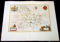
Cartographer : | Joan Blaeu | |||||||||||
| Title : | Comitatus Brechiniae Breknoke | ||||||||||||
| Date : | 1664 | ||||||||||||
| Size : | 25 1/2in x 21 1/2in (650mm x 545mm) | ||||||||||||
| Description : |
This map of the Welsh county of
Brecknock was published in the 1664 Dutch edition of Joan Blaeus Atlas Major. General Description: |
||||||||||||
| Condition : | (A+) Fine Condition | ||||||||||||
| Price :
Ref. No. : |
|||||||||||||
|
|||||||||||||