Search the entire catalogue by entering a key search term in the ‘search’ box or browse our stock by selecting from the list of categories below.
MAPS BRITISH ISLES
![]()
![]()
|
|||||||||||||
|
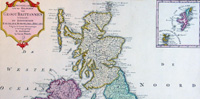
Cartographer : | Isaac Tirion | |||||||||||
| Title : | Nieuwe Kaaart van de Eilanden Groot Britannie behelsende Het Koningryk Engeland | ||||||||||||
| Date : | 1750 | ||||||||||||
| Size : | 21 1/2in x 17in (545mm x 435mm) | ||||||||||||
| Description : |
This beautifully hand coloured original antique map of Great Britain & Ireland was published by Isaac Tirion in 1750. (Ref: Tooley; M&B)
General Description: |
||||||||||||
| Condition : | (A+) Fine Condition | ||||||||||||
| Price :
Ref. No. : |
|||||||||||||
|
|||||||||||||