Search the entire catalogue by entering a key search term in the ‘search’ box or browse our stock by selecting from the list of categories below.
MAPS EAST EUROPE/RUSSIA
![]()
![]()
|
|||||||||||||
|
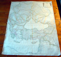
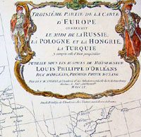
Cartographer : | Jean-Baptiste Bourguinon D'Anville | |||||||||||
| Title : | Troisieme Partie De La Carte D Europe...Russie, La Pologne, et la Hongie, La Turqie...MDCCLX | ||||||||||||
| Date : | 1760 | ||||||||||||
| Size : | 42in x 32 1/2in (1.07m x 825mm) | ||||||||||||
| Description : |
This very large
beautifully hand coloured original
antique map of eastern Europe, Russia, The Balkans,
Greece, Turkey and the Holy land was engraved in 1760 -
dated in the tile cartouche - and was published in Jean-Baptiste Bourguinon
D'Anville's large elephant folio
atlas Atlas Generale.
These
large maps are hard to find in such good condition
and make fantastic historical reference tools due to the
size and high level of detail as with all D'Anvilles
work.
(Ref: Tooley, M&B)
General Description:
Imperfections: |
||||||||||||
| Condition : | (A) Very Good Condition | ||||||||||||
| Price :
Ref. No. : |
|||||||||||||
|
|||||||||||||