Search the entire catalogue by entering a key search term in the ‘search’ box or browse our stock by selecting from the list of categories below.
MAPS WESTERN EUROPE
![]()
GREECE
![]()
|
|||||||||||||
|
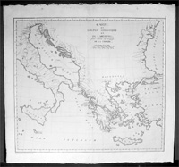
Cartographer : | Jean-Baptiste Lechevalier | |||||||||||
| Title : | Carte Du Golphe Adriatique et De L Archipel pour servir ou Voyage de la Troade | ||||||||||||
| Date : | 1802 | ||||||||||||
| Size : | 20in x 19in (510mm x 485mm) | ||||||||||||
| Description : |
This
Jean-Baptiste Lechevalier was the secretary of
the Ambassador of France in Constantinople. In the year
1788 he visited the plain of Troy, and was
enthusiastically in favour of the theory that the site
of Homer's Troy was to be found at the village of
Bunarbashi. His title, "Voyage de la Troade" was first
published in 1799. The
Troad, also known as Troas, is the
historical name of the Biga peninsula (Biga
Yarımadası, Τρωάς)
in the northwestern part of Anatolia, Turkey. This
region now is part of the Çanakkale province of Turkey.
Bounded by the Dardanelles to the northwest, by the
Aegean Sea to the west and separated from the rest of
Anatolia by the massif that forms Mount Ida, the Troad
is drained by two main rivers, the Scamander (Karamenderes)
and the Simois, which join at the area containing the
ruins of Troy. Grenikos, Kebren, Simoeis, Rhesos,
Rhodios, Heptaporos and Aisepos were seven rivers of the
Troad and the names of the river gods that inhabited
each river.(Ref:
M&B; Tooley)
General Description:
Imperfections: |
||||||||||||
| Condition : | (A+) Fine Condition | ||||||||||||
| Price :
Ref. No. : |
|||||||||||||
|
|||||||||||||