Search the entire catalogue by entering a key search term in the ‘search’ box or browse our stock by selecting from the list of categories below.
MAPS WESTERN EUROPE
![]()
FRANCE
![]()
|
|||||||||||||
|
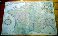
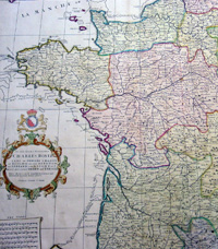
Cartographer : | John Senex | |||||||||||
| Title : | France Corrected from ye Observations made by the Royal Academy of Sciences at Paris by John Senex | ||||||||||||
| Date : | 1720 | ||||||||||||
| Size : | 37in x 26in (940m x 660mm) | ||||||||||||
| Description : |
This very large
beautifully hand coloured original antique Map of
France was engraved for John Senex for
publication in his Elephant Folio Atlas 1720. A large,
attractive map of France incorporating many corrections
in the coastal configurations of Cornwall (England),
France and Italy. This map is unusual in that it shows
the erroneous outlines of earlier cartographers and
labels the mistakes "Monsr. Sanson and the Dutch Maps",
which shadow the corrected coasts. General Description: |
||||||||||||
| Condition : | (A) Very Good Condition | ||||||||||||
| Price :
Ref. No. : |
|||||||||||||
|
|||||||||||||