Search the entire catalogue by entering a key search term in the ‘search’ box or browse our stock by selecting from the list of categories below.
MAPS WESTERN EUROPE
![]()
FRANCE
![]()
|
|||||||||||||
|
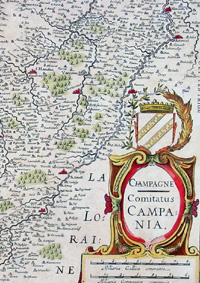
Cartographer : | Jan Jansson | |||||||||||
| Title : | Champagne - Comitatus Campania | ||||||||||||
| Date : | 1619 | ||||||||||||
| Size : | 24in x 19 1/2in (610mm x 495mm) | ||||||||||||
| Description : |
This finely engraved beautifully hand coloured original map of the Champagne region of France was published by Jan Jansson in the 1619 Edition of Atlas Novus.(Ref Tooley M&B) General Description: |
||||||||||||
| Condition : | (A+) Fine Condition | ||||||||||||
| Price :
Ref. No. : |
|||||||||||||
|
|||||||||||||