Asia (2)
1719 H. Chatelain Large Antique Map of North America Canada Great Lakes, Detroit
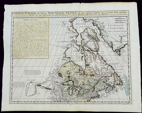
- Title : Carte du Canada ou de la Nouvelle France, & des Decouvertes qui y ont ete Faites, Dressee sur les observations les plus Nouvelles, & sur divers Memoires tant Manuscrits qu' imprimez
- Ref #: 17044
- Size: 23 1/4in x 19in (590mm x 480mm)
- Date : 1719
- Condition: (A+) Fine Condition
Description:
This large original beautifully hand coloured copper plate engraved antique & important early map of The Great Lakes, Canada & the Upper Mid-West - with descriptive French text to the right of the map - was published by Henri Abraham Chatelain in 1719, in his famous Atlas Historique.
General Definitions:
Paper thickness and quality: - Heavy and stable
Paper color : - off white
Age of map color: - Early
Colors used: - Yellow, green, blue, pink
General color appearance: - Authentic
Paper size: - 23 1/4in x 19in (590mm x 480mm)
Plate size: - 20 1/2in x 16 1/2in (525mm x 415mm)
Margins: - Min 1in (25mm)
Imperfections:
Margins: - None
Plate area: - None
Verso: - None
Background:
Nice example of Chatelain's edition of De L'Isle's seminal map of Canada, the Great Lakes and Upper Midwest, first issued in 1703.
Chatelain's map of Canada & the Great Lakes was the first printed map to locate Detroit, first issued only 2 years after the founding of the Village by Cadillac. De L'Isle studied at the French Maritime Ministry from 1700 to 1703, during which time he took extensive notes on the work of the Jesuit Missionaries, including Franquelin, Jolliet and others. Karpinksi note that the fruits of De L'Isle's substantial efforts are born out by the great improvements in the mapping of the 5 Great Lakes and other parts of the map.
The map is one of the most important maps of Canada printed during its time, and was included in Chatelain's Atlas Historique. Numerous trading posts and missions in New France and the major towns of the adjacent British colonies are shown. The area around Hudson's Bay is inhabited by native tribes referred to as the "Christinaux or Kilistinons," while Labrador is home to the "Eskimaux."
The map features a number of notes specifically referring to the names of explorers and the dates in which they discovered certain places, such as the reference to 'Nouveau Danemarc', discovered by the Danish explorer Jan Munk in 1619. The depiction of the upper Mississippi and Ohio basins is also quite detailed, noting the French fort of 'St. Louis' or 'Crevecouer' near the present-day site of Peoria, Illinois. Perhaps the most fascinating aspect of the map is its portrayal of the "Riviere Longue," one of the most sensational and enduring cartographic misconceptions ever devised. This mythical river was reported to flow from the 'Pays des Gnacsitares' in the far west, promising the best route through the interior of the continent, supposedly placing one within close reach of the Pacific Ocean. It is a product of the imagination of the Baron Lahontan, a French adventurer, whose best-selling travel narrative Nouveaux voyages dans l'Amérique septentrionale (1703) convinced many of the world's greatest intellects of the existence of this mythical waterway. The text, 'Remarque Historique' that fills the northwestern part of the map describes the history of New France from the days of Jacques Cartier to contemporary times.
1680 Frederick de Wit Large Antiue Map of Tartary, China, Japan, Mogul, Formosa
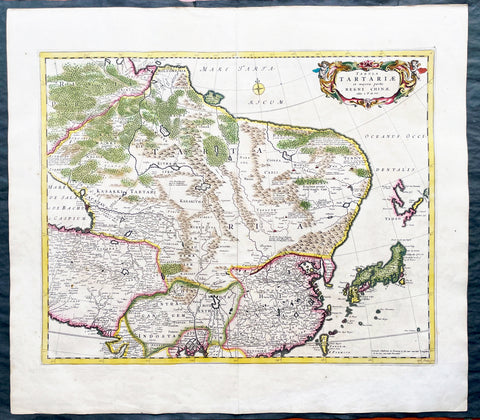
- Title : Magnae Tartariae Magni Mogolis Imperii, Japoniae et Chinae...F de Wit
- Ref #: 17030
- Size: 25in x 22 1/2in (635mm x 570mm)
- Date : 1680
- Condition: (A+) Fine Condition
Description:
This large, handsome original hand coloured copper plate engraved antique map of Tartary including China, Japan, Central Asia, parts of the Mogul Empire, Persia and Siberia - was published by Fredrick De Wit in 1680.
The map is finely engraved with detail, with fine original colour on sturdy, strong paper.
General Definitions:
Paper thickness and quality: - Heavy and stable
Paper color : - off white
Age of map color: - Early
Colors used: - Yellow, orange
General color appearance: - Authentic
Paper size: - 25in x 22 1/2in (635mm x 570mm)
Plate size: - 22in x 17 1/2in (560mm x 445mm)
Margins: - Min 1in (25mm)
Imperfections:
Margins: - Light age toning
Plate area: - Light age toning
Verso: - Light age toning
Background:
Although Arabia, Persia, the Silk road to China and those parts of Northern India conquered by Alexander the Great were known to the classical world, it was not until the year AD 1375 that a map giving some idea of the real shape and size of Asia was compiled. This was the famous Catalan Map, based on reports of Franciscan missionaries and the writings of Marco Polo. A century or so later in the first Ptolemaic Atlases, there were altogether twelve maps of Asia which, of course, revealed no more or less than Ptolemy's view of the Ancient world, but in the expanded Waldseemuller editions of 1513 and 1532 there were modern regional maps including much information from Marco Polo's travels.
Later 16th century maps continue to show many of the distorted outlines copied from Ptolemy although by this time India, Ceylon and the Indies were gaining more recognizable shape. Munster was again the first publisher to print a separate map of Asia and later Ortelius issued the first separately printed map of China in 1584 and Japan in 1595. In the next century highly decorative maps were published by Van Den Keere in 1614, Speed 1627, Blaeu 1630, De Wit 1660, Visscher 1680 and others too numerous to list. (Ref: Tooley, M&B)