Recent Acquisitions (2)

1662 Joan Blaeu Complete Set of 9 Antique Maps of North America from Atlas Major, 1st Edition
- Titles:
1. Extrema Americae....Terra Nova Francia;
2. Nova Belgica Et Anglia Nova;
3. Nova Virginiae Tabula;
4. Virginiae partis australis, et Floridae;
5. Nova Hispania;
6. Yucatan...Guatimala;
7. Insulae Americanae;
8. Canibales Insulae;
9. Mappa Aestivarum Insularum Alias Barmudas - Sizes: 24in x 20 1/2in (610mm x 520mm)ea
- Condition: (A+) Fine Condition
- Date: 1662
- Ref #: BlaeuNA 1662
Description:
This is a unique opportunity to acquire a complete set of 9 maps of North America published by Joan Blaeus in the monumental & rare 1st 1662 Latin edition of Atlas Major. The maps cover the geographical detail of Canada, North America, Mexico, The Caribbean & Central America. Please see the background section below for details of each map. All maps have wide original margins & colour on strong sturdy paper.
Joan Blaeus 11 volumes of Atlas Major, is considered by many to be the greatest atlas set ever published. It excels in comprehensiveness, engraving, color, and overall production. The first edition was published in Latin in 1662 and was subsequently published in French, Dutch, German, and Spanish over the next 10 years.
On the 23rd of February 1672, a fire broke out in central Amsterdam, that ended the reign of one of the greatest & most prolific publishers of printed maps and atlases in publishing history. The Blaeu family had reached its zenith 10 years previously, with the publication of its greatest achievement, the Atlas Major or Great Atlas, consisting of 11 volumes, with geographical detail reflecting many of the achievements of the Golden Age of the United Netherlands. Blaeus Atlas Major were the most expensive books printed in the 17th century.
General Definitions:
Paper thickness and quality: - Heavy and stable
Paper color : - off white
Age of map color: - Original
Colors used: - Blue, pink, red, green, yellow
General color appearance: - Authentic
Paper size: - 24in x 20 1/2in (610mm x 520mm)
Plate size: - Various, pls see below
Margins: - Min 1in (25mm) min
Imperfections:
Margins: - Pls see below
Plate area: - Pls see below
Verso: - Pls see below
Background:
1. Extrema Americae ( Eastern Canada) - Rare only published in Atlas Major. Derived mainly from the Samuel de Champlain Nouvelle France map of 1632, this map reflects the growing financial importance of the waters of New France to Europe.
Plate: 22 1/2in x 17 3/4in.
Condition: Age toning, text show-through & browning to image.
2. Nova Belgica Et Anglia Nova (New England) - NE America, centering on New York and Manhattan from Virginia to the St Lawrence River. This map is noted for the fact that its primary source is the first manuscript figurative map of Adriaen Block from 1614. Indeed it is the first full representation of it in print. It is one of the earliest to name Nieu Amsterdam. Block, a Dutch fur trader, explored the area between Cape Cod and Manhattan, examining the bays and rivers along the way.
Plate: 19 1/2in x 15 1/2in
Condition: Age toning, text show-through & browning to image.
3. Nova Virginiae Tabula (John Smiths Virginia & Chesapeake Bay) This map was printed from a plate engraved by Dirk Grijp from a previous plates by Henricus Hondius.
Plate: 19in x 15in
Condition: Light age toning
4. Virginiae partis australis, et Floridae Virginia, the Carolinas & Georgia.
Plate: 20in x 15in
Condition: Light age toning
5. Nova Hispania et Nova Galicia Western Mexico
Plate: 19 1/2in x 15 1/2in
Condition: Light age toning
6. Yucatan...Guatimala (Yucatan, Central America) Rare only published in Atlas Major.
Plate: 20 1/2in x 16 1/2in
Condition: Light age toning
7. Insulae Americana (GOM, Caribbean)
Plate: 20 1/2in x 15in
Condition: Light age toning
8. Canibales Insulae (Lesser Antilles Islands) Rare, printed only in Atlas Major
Plate: 21in x 16 1/2in
Condition: Age toning
9. Mappa Aestivarum Insularum Alias Barmudas Dictarum Bermuda. Like all 17th century maps of Bermuda this map is based ultimately on the survey made by John Norwood, of the Bermuda Company, in 1618 in the form as published by the English map-maker John Speed in 1627.
Plate: 21in x 16in
Condition: Light age toning
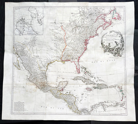
1746 J B D Anville Large Rare Antique Map of North America Pre French Indian War
-
Title : Amerique Septentrionale Publiee sous les Auspices de Monseigneur le Duc d Orleans.. Par Le Snr. D Anville MDCCXLVI
- Ref #: 17010
-
Condition: (A+) Fine Condition
- Size: 42 1/2in x 37in (1.08m x 940mm)
- Date : 1746
Description:
This large important original copper plate engraved antique map of North America, in 12 sheets joined, was engraved in 1746 - dated in the cartouche - and was published by Jean-Baptiste Bourguinon D Anville in his Elephant Folio Atlas Generale.
This map was instrumental in instructing the European Colonial powers of the time, England France & Spain the importance of dominating the New World, that ultimately led to the French and Indian War of 1754–63. This conflict determined the political direction of North America leading to the American War of Independence in 1775 and ultimately the formation of The United States of America.
To illustrate the importance of cartography in the mid eighteenth century, especially that of North America, a J B D Anville map is essential. D Anville dominated 18th century European cartography with many of his cartographical achievements, especially in North America, copied by many of his contemporaries such as Kitchen, Sayer, Homann, Seutter, Mitchell and others .
He was one of the first to leave blank spaces in his maps, where knowledge was scant or insufficient. His representation of the great lakes is superior to that of his contemporary John Mitchell, responsible for publishing one of the most famous mid 18th century maps of North America, A Map of the British and French Dominions in North America on 8 sheets in 1755 and remained the standard map of North America up until the end of the 18th century. (Ref: Tooley, Printed maps of America, 104; The Mapping of America 316)
General Definitions:
Paper thickness and quality: - Heavy and stable
Paper color : - off white
Age of map color: - Original
Colors used: - Red, yellow, green, blue
General color appearance: - Authentic
Paper size: - 42 1/2in x 37in (1.08m x 940mm)
Plate size: - 34 1/2in x 33 1/2in (875m x 850mm)
Margins: - Min 1in (25mm)
Imperfections:
Margins: - Small wormholes in left margin repaired, not affecting the image
Plate area: - Light age toning
Verso: - Age toning
Background:
The French and Indian War (1754–63) comprised the North American theatre of the worldwide Seven Years War of 1756–63. It pitted the colonies of British America against those of New France. Both sides were supported by military units from their parent countries, as well as by American Indian allies. At the start of the war, the French North American colonies had a population of roughly 60,000 settlers, compared with 2 million in the British North American colonies. The outnumbered French particularly depended on the Indians. The European nations declared war on one another in 1756 following months of localized conflict, escalating the war from a regional affair into an intercontinental conflict.
The name French and Indian War is used mainly in the United States. It refers to the two enemies of the British colonists, the royal French forces and their various American Indian allies. The British colonists were supported at various times by the Iroquois, Catawba, and Cherokee, and the French colonists were supported by Wabanaki Confederacy members Abenaki and Mikmaq, and Algonquin, Lenape, Ojibwa, Ottawa, Shawnee, and Wyandot.
British and other European historians use the term the Seven Years War, as do English-speaking Canadians. French Canadians call it La guerre de la Conquête (the War of the Conquest) or (rarely) the Fourth Intercolonial War.
Fighting took place primarily along the frontiers between New France and the British colonies, from Virginia in the south to Newfoundland in the north. It began with a dispute over control of the confluence of the Allegheny River and Monongahela River called the Forks of the Ohio, and the site of the French Fort Duquesne in Pittsburgh, Pennsylvania. The dispute erupted into violence in the Battle of Jumonville Glen in May 1754, during which Virginia militiamen under the command of 22-year-old George Washington ambushed a French patrol.
In 1755, six colonial governors in North America met with General Edward Braddock, the newly arrived British Army commander, and planned a four-way attack on the French. None succeeded, and the main effort by Braddock proved a disaster; he lost the Battle of the Monongahela on July 9, 1755 and died a few days later. British operations failed in the frontier areas of Pennsylvania and New York during 1755–57 due to a combination of poor management, internal divisions, effective Canadian scouts, French regular forces, and Indian warrior allies. In 1755, the British captured Fort Beauséjour on the border separating Nova Scotia from Acadia, and they ordered the expulsion of the Acadians (1755–64) soon afterwards. Orders for the deportation were given by William Shirley, Commander-in-Chief, North America, without direction from Great Britain. The Acadians were expelled, both those captured in arms and those who had sworn the loyalty oath to His Britannic Majesty. Indians likewise were driven off the land to make way for settlers from New England.
The British colonial government fell in the region of modern Nova Scotia after several disastrous campaigns in 1757, including a failed expedition against Louisbourg and the Siege of Fort William Henry; this last was followed by Indians torturing and massacring their British victims. William Pitt came to power and significantly increased British military resources in the colonies at a time when France was unwilling to risk large convoys to aid the limited forces that they had in New France, preferring to concentrate their forces against Prussia and its allies in the European theater of the war. Between 1758 and 1760, the British military launched a campaign to capture the Colony of Canada (part of New France). They succeeded in capturing territory in surrounding colonies and ultimately the city of Quebec (1759). The British later lost the Battle of Sainte-Foy west of Quebec (1760), but the French ceded Canada in accordance with the Treaty of Paris (1763).
The outcome was one of the most significant developments in a century of Anglo-French conflict. France ceded to Great Britain its territory east of the Mississippi. It ceded French Louisiana west of the Mississippi River (including New Orleans) to its ally Spain in compensation for Spains loss to Britain of Florida. (Spain had ceded Florida to Britain in exchange for the return of Havana, Cuba.) Frances colonial presence north of the Caribbean was reduced to the islands of Saint Pierre and Miquelon, confirming Great Britains position as the dominant colonial power in eastern North America.
Please note all items auctioned are genuine, we do not sell reproductions. A Certificate of Authenticity (COA) can be issued on request.