Recent Acquisitions (2)
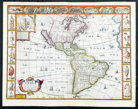
1626 (1676) John Speed Antique Map of America - Beautiful Condition
- Title : America with those known parts in that unknowne world both people and manner of buildings discribed and inlarged by I.S. Ano 1626.
- Date : 1626 (1676)
- Size: 21 1/2in x 17in (545mm x 430mm)
- Condition: (A+) Fine Condition
- Ref: 35654
Description:
This original hand coloured copper plate engraved antique map of America by John Speed was published in the 1676 Bassett & Chiswell edition of Speeds famous atlas Prospect of the Most Famous Parts of the World.
One of the best examples of this map I have seen. Beautiful original condition with original hand colour, clean heavy impression on sturdy clean paper with original margins, which is very rare.
This 1626 map of America is the fourth or 1676 state and is one of the most iconic maps of America, surrounded by decorative vignettes illustrating the indigenous peoples and cities of the Americas. This map is both beautiful and important. It features a number of first, including being the first atlas map to depict California as an island and to accurately depict the east coast of North America. Cartographically it follows on the earlier maps of the Dutchman Abraham Goos, the engraver, with updates to reflect the 1625 Briggs vision of an insular California
General Definitions:
Paper thickness and quality: - Heavy and stable
Paper color : - off white
Age of map color: - Original
Colors used: - Yellow, green, blue, pink
General color appearance: - Authentic
Paper size: - 21 1/2in x 17in (545mm x 430mm)
Plate size: - 20 1/4in x 15 1/2in (515mm x 395mm)
Margins: - Min 3/4in (20mm)
Imperfections:
Margins: - None
Plate area: - None
Verso: - Old archival hinge paper top of verso, not affecting the map.
Background:
This is the first atlas map to represent California as an island. The idea of an insular California first appeared as a work of fiction in Garci Rodriguez de Montalvo's c. 1510 romance Las Sergas de Esplandian, where he writes
.....Know, that on the right hand of the Indies there is an island called California very close to the side of the Terrestrial Paradise; and it is peopled by black women, without any man among them, for they live in the manner of Amazons.....
Baja California was subsequently discovered in 1533 by Fortun Ximenez, who had been sent to the area by Hernan Cortez. When Cortez himself traveled to Baja, he must have had Montalvo's novel in mind, for he immediately claimed the 'Island of California' for the Spanish King. By the late 16th and early 17th century ample evidence had been amassed, through explorations of the region by Francisco de Ulloa, Hernando de Alarcon and others, that California was in fact a peninsula. However, by this time other factors were in play. Francis Drake had sailed north and claimed 'New Albion' (identified here on the northwest coast of California Island) near modern day Washington or Vancouver for England. The Spanish thus needed to promote Cortez's claim on the 'Island of California' to preempt English claims on the western coast of North America. Henry Briggs, an English mathematician, began promoting the idea of an insular California in 1622, citing the journals of Friar Antonio de la Ascension, who accompanied the 1602-03 Sebastian Vizcaino expedition. The significant influence of the Spanish crown on European cartographers caused a major resurgence of the Insular California theory. Just before this map was made Eusebio Kino, a Jesuit missionary, traveled overland from Mexico to California, proving conclusively the peninsularity of California. Even so, it was ultimately a 1747 royal decree from King Ferdinand VII of Spain that finally forced cartographers to give up on the alluring idea.
Other elements of interest in North America are the complete absence of the Great Lakes - which in 1626 had yet to be conceived of by any European cartographers. The Straits of Anian appear tenuously in the extreme northwest, just above California. Just east of the 'o' in 'California', on the continental mainland, there is a curious ghosted in lake called the 'Lagueo de Oro.' We have found no references or explanation for this. None of the legendary kingdoms of gold, Quivara, Teguayo, Cibola, etc. are noted. The western portions of the Hudson Bay are unmapped - suggestive of their unexplored status. The addition of Long Island and Boston, in notably darker print, are important updates over the earliest editions.
South America offers much of interest including the mythical Lake Parimia, in Guiana. The legend of Parima is associated with the English adventurer Sir Walter Raleigh's search for El Dorado. Believing El Dorado to lie in the northern part of the Amazon, Raleigh sailed down the Orinoco River just before the onset of the rainy season. Reaching a remote tribal village, Raleigh noted canoes arriving bearing gold, silver, and other treasures. Asked where the gold came from, the natives replied, 'Manoa', the term for the tribe to which the river traders belonged. Manoa, the natives claimed could be reached following a long river voyage southward to a Great Lake, called Parima. Raleigh and his associates immediately associated Manoa and Lake Parima with the golden kingdom of El Dorado, though they never visited the city or lake. Subsequent maps, including this one, mapped el Dorado and Lake Parima in this location for several hundred years. Both Raleigh and the natives were describing an actual event known to occur annually in the region. Rains would annually swell the Amazon and Orinoco river systems creating a linkage in the Rupununu flood plain, which, during heavy rains, can resemble a massive lake. The Manoa were a large and populous trading nation active in pre-colonial days whose vast empire, based in the Amazon Basin, extended form the Andes to the Orinoco. Curiously, in addition to noting the city of Manoa on Lake Parima, D'Anville also correctly maps the center of the ancient Manoan civilization between the Amazon tributaries Rio Negro and Rio Yapura. Sadly the Manoa and many of the other populous South American indigenous nations noted by the earliest explores to the region vanished, brought low by European epidemics.
Another mythical lake, Eupana, appears further south connecting the Rio de la Plata and the Paraguay River to the R. Real, thus turning eastern Brazil into an island. This is a update over many earlier maps which connected Eupana directly to the Amazon. Far in the south Speed presents us ith another anomaly, the Straits of Le Maire, which separates Tierra de Fuego from another mysterious stretch of land labeled 'States Land.' The is in fact the modern island of Isla de los Estados, the southeastern most point in South America. Jacob le Maire and his pilot Willem Schouten passed to between this island and Tierra del Fuego on their 1615 voyage around Cape Horn and into the Pacific.
In the high Arctic, near Iceland and Greenland, the supposed islands of Frisland and Brasil are noted. Frisland is little more than a double mapping of Iceland. Brasil, also known as Hy-Brasil, is a phantom island north Atlantic just west of Ireland. In Irish myths it was said to be cloaked in mist, except for one day every seven years, when it became visible but still could not be reached. Little is known of this origins of this myth, but it appears on maps in various forms from about 1325. The last known appearance was in 1865 when it appeared on a nautical chart as 'Brasil Rock.' Some speculate that it may be an early reference to Porcupine Bank, a shoal in the Atlantic Ocean about 200 kilometres (120 mi) west of Ireland.
Speed's map of America is especially noteworthy for its surrounded vignettes. To either side of the map proper there are various vignettes illustrating the indigenous peoples of the America. These includes natives of Greenland, Virginia, Florida, Mexico, New England, Peru, Brazil, and Tierra del Feugo.n Along the top of the map there are eight city views: Havanna, Santo Domingo, Cartagena, Mexico City, Cuzco, the isle of Moca, Rio de Janeiro, and Olinda.
This map was engraved for John Speed by Abraham Goos. It is the fourth state of the map issued by Thomas Bassett of Fleet Street and Richard Chiswell of St. Paul's Churchyard. Bassett, Chiswell, and others continued to republish Speed's work well after his death. (Ref: Tooley, Koeman, Burden)
Please note all items auctioned are genuine, we do not sell reproductions. A Certificate of Authenticity (COA) can be issued on request.
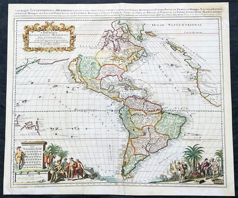
1695 Gerard Valk Antique Map of North & South America, California as an Island
- Title : L'Amerique Septentrionale & Meridionale divisee en ses principales parties
- Ref #: 35624
- Condition: (B) Good Condition
- Size: 24 1/4in x 20 3/4in (615mm x 530mm)
- Date: 1695
Description:
This original, copper plate engraved scarce antique map of the Americas, showing California as an Island, was published in the last decade of the 18th century in ca 1695.
This map is relatively rare as it was not included in any standard atlas but was optional, allowing the buyer to choose this along with other engraved map, to include in a bespoke atlas.
This map has undergone some professional restoration, it is complete and has been re-enforced in places on the verso along existing creases to the left and right side center of the map (please see images) as well as re-enforcement along centerfold and corners. Please see images and description below. Priced with condition in mind.
General Definitions:
Paper thickness and quality: - Light and stable
Paper color : - White
Age of map color: - Original & later
Colors used: - Yellow, green, blue, pink
General color appearance: - Authentic
Paper size: - 24 1/4in x 20 3/4in (615mm x 530mm)
Plate size: - 23in x 19 3/4in (590mm x 505mm)
Margins: - Min 1/2in (12mm)
Imperfections:
Margins: - Top right & bottom left corners of margins restored, age toning, several small repairs to margins not affecting the images
Plate area: - Creasing to image, centerfold re-joined
Verso: - Old creasing re-enforced with archival tape to verso, creasing, age toning
Background:
Scarce map of America, published in Amsterdam by Gerard Valk. Valk's map of California shows many of the most fascinating myths of the 17th Century. California is shown as an island on the so-called "second Sanson Model." A massive land bridge extends from just west of Capo Blanco on the northern California coastline to Niphon, a curious adaptation of the legend of Compagnie Land (shown here as a place name -- Terre de la Compagne) and the continuous land bridge from America to Asia, although adding the Detroit de Tzungaar (Strait of Tzungaar), a very rarely mentioned mythical Strait between two islands of Japan.
The Great Lakes are oddly configured, with Lake Superior and Lake Michigan open ended to the West. The Mississippi River is very ill conceived, pre-dating the radical improvements which would come with Guilluame De L'Isle's map of North America of 1700 and Carte du Mexique of 1703.
The fine allegorical cartouches depict the booming trade then being conducted by Europeans in the New World.
Valk, Gerard 1651 - 1726
Gerard Valk was a prominent Dutch engraver, publisher, and art dealer during the late 17th and early 18th centuries. He is best known for his contributions to the field of cartography and his collaborations with renowned artists and mapmakers of his time.
Valk was born on April 6, 1651, in Amsterdam, the Netherlands. Little is known about his early life and education, but it is believed that he received training as an engraver, possibly under the tutelage of his father, Balthasar Valk, who was also an engraver and publisher.
In the late 1670s, Gerard Valk established his own publishing firm in Amsterdam, specializing in the production of maps, atlases, and prints. He quickly gained recognition for his skill as an engraver and his ability to produce high-quality, detailed maps. Valk's maps were often based on the work of renowned cartographers of the time, such as Frederik de Wit and Nicolaes Visscher, whose plates he acquired and reprinted.
Valk's maps covered a wide range of geographical regions, including Europe, Asia, Africa, and the Americas. His maps were meticulously crafted, featuring elaborate cartouches, decorative elements, and accurate geographic information. He also collaborated with notable artists and engravers, such as Jan Luyken and Romeyn de Hooghe, who provided illustrations and embellishments for his publications.
Apart from cartography, Valk also published and sold prints of various subjects, including portraits, landscapes, historical scenes, and genre paintings. He catered to a diverse clientele, ranging from collectors and scholars to wealthy individuals and institutions.
Valk's publishing business flourished, and he enjoyed considerable success and acclaim during his lifetime. His maps and prints were highly sought after for their quality and accuracy. He maintained a strong network of contacts throughout Europe, including fellow publishers, mapmakers, and merchants, which allowed him to expand his business and reach a wider market.
Gerard Valk passed away on August 26, 1726, in Amsterdam, leaving behind a legacy as a skilled engraver, publisher, and contributor to the development of cartography. His work played a significant role in disseminating geographical knowledge and capturing the aesthetic beauty of maps during the late 17th and early 18th centuries. Today, Valk's maps and prints are considered valuable collectors' items, cherished for their historical and artistic value.