Architectural (84)
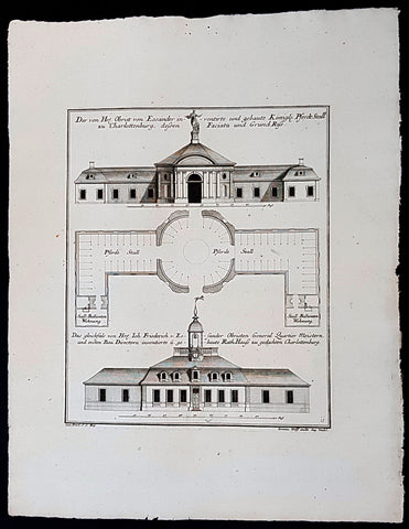
1740 Wolff & Corvinus Antique Arch Print of Charlottenburg Palace Stables Berlin
Antique Map
- Title : Der von Hr. Obrist von Eosander inventirte und gebaute Königl. Pferdt Stall zu Charlottenburg, dessen Faciata und Grund Riss. - Das gleichfals von Hr. Joh. Friederich v. Eosander Obristen General Quartier Meistern, und ersten Bau Directorn inventierte und gebaute Rath Hauss zu gedachten Charlottenburg
- Ref #: 93453
- Size: 19in x 12 1/2in (490mm x 335mm)
- Date : 1740
- Condition: (A+) Fine Condition
Description:
This large rare, original copper-plate engraved antique architectural print of the Royal Horse Stables at Charlottenburg Palace, Berlin - plate No. 11 of 16 - by Johann August Corvinus 1683 - 1738, after Andreas Mayers 1716 - 1782, was published in Eigentliche Abbildung des Prächtigen Königl. Lust Schlosses Charlottenburg, eine Meile von Berlin, sambt dem darhinden im Walde gelegenen schönen Lust Garten
(Set of 16 numbered plates, the first with the title, with plans and views of the buildings and gardens at Charlottenburg, the palace of the King of Prussia on the outskirts of Berlin.) by Jeremias Wolff Erben in 1740.
General Definitions:
Paper thickness and quality: - Heavy and stable
Paper color : - off white
Age of map color: -
Colors used: -
General color appearance: -
Paper size: - 19in x 12 1/2in (490mm x 335mm)
Plate size: - 14 1/2in x 10 1/2in (370mm x 260mm)
Margins: - Min 1in (25mm)
Imperfections:
Margins: - None
Plate area: - None
Verso: - None
Background:
Berlin straddles the banks of the River Spree, which flows into the River Havel (a tributary of the River Elbe) in the western borough of Spandau. Among the citys main topographical features are the many lakes in the western and southeastern boroughs formed by the Spree, Havel, and Dahme rivers (the largest of which is Lake Müggelsee). Due to its location in the European Plain, Berlin is influenced by a temperate seasonal climate. About one-third of the citys area is composed of forests, parks, gardens, rivers, canals and lakes. The city lies in the Central German dialect area, the Berlin dialect being a variant of the Lusatian-New Marchian dialects.
First documented in the 13th century and situated at the crossing of two important historic trade routes, Berlin became the capital of the Margraviate of Brandenburg (1417–1701), the Kingdom of Prussia (1701–1918), the German Empire (1871–1918), the Weimar Republic (1919–1933), and the Third Reich (1933–1945). Berlin in the 1920s was the third-largest municipality in the world. After World War II and its subsequent occupation by the victorious countries, the city was divided; West Berlin became a de facto West German exclave, surrounded by the Berlin Wall (1961–1989) and East German territory. East Berlin was declared capital of East Germany, while Bonn became the West German capital. Following German reunification in 1990, Berlin once again became the capital of all of Germany.
The Thirty Years War between 1618 and 1648 devastated Berlin. One third of its houses were damaged or destroyed, and the city lost half of its population. Frederick William, known as the Great Elector, who had succeeded his father George William as ruler in 1640, initiated a policy of promoting immigration and religious tolerance. With the Edict of Potsdam in 1685, Frederick William offered asylum to the French Huguenots.
By 1700, approximately 30 percent of Berlins residents were French, because of the Huguenot immigration. Many other immigrants came from Bohemia, Poland, and Salzburg.
Since 1618, the Margraviate of Brandenburg had been in personal union with the Duchy of Prussia. In 1701, the dual state formed the Kingdom of Prussia, as Frederick III, Elector of Brandenburg, crowned himself as king Frederick I in Prussia. Berlin became the capital of the new Kingdom, replacing Königsberg. This was a successful attempt to centralise the capital in the very far-flung state, and it was the first time the city began to grow. In 1709, Berlin merged with the four cities of Cölln, Friedrichswerder, Friedrichstadt and Dorotheenstadt under the name Berlin, Haupt- und Residenzstadt Berlin.
In 1740, Frederick II, known as Frederick the Great (1740–1786), came to power. Under the rule of Frederick II, Berlin became a center of the Enlightenment, but also, was briefly occupied during the Seven Years War by the Russian army. Following Frances victory in the War of the Fourth Coalition, Napoleon Bonaparte marched into Berlin in 1806, but granted self-government to the city. In 1815, the city became part of the new Province of Brandenburg.
The Industrial Revolution transformed Berlin during the 19th century; the citys economy and population expanded dramatically, and it became the main railway hub and economic centre of Germany. Additional suburbs soon developed and increased the area and population of Berlin. In 1861, neighbouring suburbs including Wedding, Moabit and several others were incorporated into Berlin. In 1871, Berlin became capital of the newly founded German Empire. In 1881, it became a city district separate from Brandenburg.
Wolff, Jeremais 1663 - 1724
Wolff was an German engraver and publisher. Born in Augsburg, he originally trained as a clock and automat maker, later changing course and opening a small copperplate engraving shop. His success was impressive and became one of the largest European art, print & map publishers in the first half of the 18th century. Wolff employed some of the best engravers of the time and although not an engraver himself, only Wolffs name was recorded on the engravings. Many of his engravers went uncredited for their work. In 1710 Wolff was one of the founder member of the Empire State Academy of Arts in Augsburg.
After his death in 1724, Wolffs publishing business was inherited by his sons and son-in-law, Johann Balthasar Probst (1673–1750) a notable engraver at the time. The firm continued on in Augsburg under the name Jeremias Wolff Erben.
Together with the Nuremberg copperplate engraver Paul Decker , Wolff published a series of engravings showing the war successes of Prince Eugene of Savoy in Italy , southern Germany and the Spanish Netherlands, during the War of the Spanish Succession . The prints are exhibited in the Museum of Military History, in Vienna .
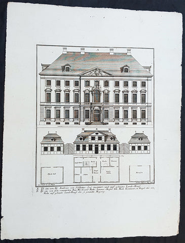
1740 Wolff & Corvinus Antique Arch Print of Berlin Mansions by A. von Schlütter
Antique Map
- Title : A. Ist ein von H. Andreas von Schlütter Seel. inventirt- und auff gebautes Landt-Hauss. B. Ist ein von dem renomirten Bau-Werck- und Raths Zimmer-Meister Joh. Mich. Kemmeter, in Riegel oder Holtz auff gebautes Land-Hauß oder so genandte Meyerey
- Ref #: 93445
- Size: 19in x 12 1/2in (490mm x 335mm)
- Date : 1740
- Condition: (A+) Fine Condition
Description:
This large rare, original copper-plate engraved antique architectural print of 18th century Mansions in Berlin designed by Andreas von Schlütter - plate No. 9 of 16 - by Johann August Corvinus 1683 - 1738, after Andreas Mayers 1716 - 1782, was published in Eigentliche Abbildung des Prächtigen Königl. Lust Schlosses Charlottenburg, eine Meile von Berlin, sambt dem darhinden im Walde gelegenen schönen Lust Garten
(Set of 16 numbered plates, the first with the title, with plans and views of the buildings and gardens at Charlottenburg, the palace of the King of Prussia on the outskirts of Berlin.) by Jeremias Wolff Erben in 1740.
General Definitions:
Paper thickness and quality: - Heavy and stable
Paper color : - off white
Age of map color: -
Colors used: -
General color appearance: -
Paper size: - 19in x 12 1/2in (490mm x 335mm)
Plate size: - 14 1/2in x 10 1/2in (370mm x 260mm)
Margins: - Min 1in (25mm)
Imperfections:
Margins: - None
Plate area: - None
Verso: - None
Background:
Berlin straddles the banks of the River Spree, which flows into the River Havel (a tributary of the River Elbe) in the western borough of Spandau. Among the citys main topographical features are the many lakes in the western and southeastern boroughs formed by the Spree, Havel, and Dahme rivers (the largest of which is Lake Müggelsee). Due to its location in the European Plain, Berlin is influenced by a temperate seasonal climate. About one-third of the citys area is composed of forests, parks, gardens, rivers, canals and lakes. The city lies in the Central German dialect area, the Berlin dialect being a variant of the Lusatian-New Marchian dialects.
First documented in the 13th century and situated at the crossing of two important historic trade routes, Berlin became the capital of the Margraviate of Brandenburg (1417–1701), the Kingdom of Prussia (1701–1918), the German Empire (1871–1918), the Weimar Republic (1919–1933), and the Third Reich (1933–1945). Berlin in the 1920s was the third-largest municipality in the world. After World War II and its subsequent occupation by the victorious countries, the city was divided; West Berlin became a de facto West German exclave, surrounded by the Berlin Wall (1961–1989) and East German territory. East Berlin was declared capital of East Germany, while Bonn became the West German capital. Following German reunification in 1990, Berlin once again became the capital of all of Germany.
The Thirty Years War between 1618 and 1648 devastated Berlin. One third of its houses were damaged or destroyed, and the city lost half of its population. Frederick William, known as the Great Elector, who had succeeded his father George William as ruler in 1640, initiated a policy of promoting immigration and religious tolerance. With the Edict of Potsdam in 1685, Frederick William offered asylum to the French Huguenots.
By 1700, approximately 30 percent of Berlins residents were French, because of the Huguenot immigration. Many other immigrants came from Bohemia, Poland, and Salzburg.
Since 1618, the Margraviate of Brandenburg had been in personal union with the Duchy of Prussia. In 1701, the dual state formed the Kingdom of Prussia, as Frederick III, Elector of Brandenburg, crowned himself as king Frederick I in Prussia. Berlin became the capital of the new Kingdom, replacing Königsberg. This was a successful attempt to centralise the capital in the very far-flung state, and it was the first time the city began to grow. In 1709, Berlin merged with the four cities of Cölln, Friedrichswerder, Friedrichstadt and Dorotheenstadt under the name Berlin, Haupt- und Residenzstadt Berlin.
In 1740, Frederick II, known as Frederick the Great (1740–1786), came to power. Under the rule of Frederick II, Berlin became a center of the Enlightenment, but also, was briefly occupied during the Seven Years War by the Russian army. Following Frances victory in the War of the Fourth Coalition, Napoleon Bonaparte marched into Berlin in 1806, but granted self-government to the city. In 1815, the city became part of the new Province of Brandenburg.
The Industrial Revolution transformed Berlin during the 19th century; the citys economy and population expanded dramatically, and it became the main railway hub and economic centre of Germany. Additional suburbs soon developed and increased the area and population of Berlin. In 1861, neighbouring suburbs including Wedding, Moabit and several others were incorporated into Berlin. In 1871, Berlin became capital of the newly founded German Empire. In 1881, it became a city district separate from Brandenburg.
Wolff, Jeremais 1663 - 1724
Wolff was an German engraver and publisher. Born in Augsburg, he originally trained as a clock and automat maker, later changing course and opening a small copperplate engraving shop. His success was impressive and became one of the largest European art, print & map publishers in the first half of the 18th century. Wolff employed some of the best engravers of the time and although not an engraver himself, only Wolffs name was recorded on the engravings. Many of his engravers went uncredited for their work. In 1710 Wolff was one of the founder member of the Empire State Academy of Arts in Augsburg.
After his death in 1724, Wolffs publishing business was inherited by his sons and son-in-law, Johann Balthasar Probst (1673–1750) a notable engraver at the time. The firm continued on in Augsburg under the name Jeremias Wolff Erben.
Together with the Nuremberg copperplate engraver Paul Decker , Wolff published a series of engravings showing the war successes of Prince Eugene of Savoy in Italy , southern Germany and the Spanish Netherlands, during the War of the Spanish Succession . The prints are exhibited in the Museum of Military History, in Vienna .
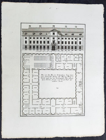
1740 Wolff & Corvinus Antique Arch Print of a Poorhouse near Stralau Gate Berlin
Antique Map
- Title : Das von dem H. von Grünenberg Seel. inventirte sogenandte Armen- oder Waysen-Hauss zu Berlin, nache bey dem Stralauischen Thor gelegen, ....
- Ref #: 93455
- Size: 19in x 12 1/2in (490mm x 335mm)
- Date : 1740
- Condition: (A+) Fine Condition
Description:
This large rare, original copper-plate engraved antique architectural print of the Poorhouse near the old Stralau Gate (Stralauer Tor) in Berlin - plate No. 8 of 16 - by Johann August Corvinus 1683 - 1738, after Andreas Mayers 1716 - 1782, was published in Eigentliche Abbildung des Prächtigen Königl. Lust Schlosses Charlottenburg, eine Meile von Berlin, sambt dem darhinden im Walde gelegenen schönen Lust Garten
(Set of 16 numbered plates, the first with the title, with plans and views of the buildings and gardens at Charlottenburg, the palace of the King of Prussia on the outskirts of Berlin.) by Jeremias Wolff Erben in 1740.
General Definitions:
Paper thickness and quality: - Heavy and stable
Paper color : - off white
Age of map color: -
Colors used: -
General color appearance: -
Paper size: - 19in x 12 1/2in (490mm x 335mm)
Plate size: - 14 1/2in x 10 1/2in (370mm x 260mm)
Margins: - Min 1in (25mm)
Imperfections:
Margins: - None
Plate area: - None
Verso: - None
Background:
Berlin straddles the banks of the River Spree, which flows into the River Havel (a tributary of the River Elbe) in the western borough of Spandau. Among the citys main topographical features are the many lakes in the western and southeastern boroughs formed by the Spree, Havel, and Dahme rivers (the largest of which is Lake Müggelsee). Due to its location in the European Plain, Berlin is influenced by a temperate seasonal climate. About one-third of the citys area is composed of forests, parks, gardens, rivers, canals and lakes. The city lies in the Central German dialect area, the Berlin dialect being a variant of the Lusatian-New Marchian dialects.
First documented in the 13th century and situated at the crossing of two important historic trade routes, Berlin became the capital of the Margraviate of Brandenburg (1417–1701), the Kingdom of Prussia (1701–1918), the German Empire (1871–1918), the Weimar Republic (1919–1933), and the Third Reich (1933–1945). Berlin in the 1920s was the third-largest municipality in the world. After World War II and its subsequent occupation by the victorious countries, the city was divided; West Berlin became a de facto West German exclave, surrounded by the Berlin Wall (1961–1989) and East German territory. East Berlin was declared capital of East Germany, while Bonn became the West German capital. Following German reunification in 1990, Berlin once again became the capital of all of Germany.
The Thirty Years War between 1618 and 1648 devastated Berlin. One third of its houses were damaged or destroyed, and the city lost half of its population. Frederick William, known as the Great Elector, who had succeeded his father George William as ruler in 1640, initiated a policy of promoting immigration and religious tolerance. With the Edict of Potsdam in 1685, Frederick William offered asylum to the French Huguenots.
By 1700, approximately 30 percent of Berlins residents were French, because of the Huguenot immigration. Many other immigrants came from Bohemia, Poland, and Salzburg.
Since 1618, the Margraviate of Brandenburg had been in personal union with the Duchy of Prussia. In 1701, the dual state formed the Kingdom of Prussia, as Frederick III, Elector of Brandenburg, crowned himself as king Frederick I in Prussia. Berlin became the capital of the new Kingdom, replacing Königsberg. This was a successful attempt to centralise the capital in the very far-flung state, and it was the first time the city began to grow. In 1709, Berlin merged with the four cities of Cölln, Friedrichswerder, Friedrichstadt and Dorotheenstadt under the name Berlin, Haupt- und Residenzstadt Berlin.
In 1740, Frederick II, known as Frederick the Great (1740–1786), came to power. Under the rule of Frederick II, Berlin became a center of the Enlightenment, but also, was briefly occupied during the Seven Years War by the Russian army. Following Frances victory in the War of the Fourth Coalition, Napoleon Bonaparte marched into Berlin in 1806, but granted self-government to the city. In 1815, the city became part of the new Province of Brandenburg.
The Industrial Revolution transformed Berlin during the 19th century; the citys economy and population expanded dramatically, and it became the main railway hub and economic centre of Germany. Additional suburbs soon developed and increased the area and population of Berlin. In 1861, neighbouring suburbs including Wedding, Moabit and several others were incorporated into Berlin. In 1871, Berlin became capital of the newly founded German Empire. In 1881, it became a city district separate from Brandenburg.
Wolff, Jeremais 1663 - 1724
Wolff was an German engraver and publisher. Born in Augsburg, he originally trained as a clock and automat maker, later changing course and opening a small copperplate engraving shop. His success was impressive and became one of the largest European art, print & map publishers in the first half of the 18th century. Wolff employed some of the best engravers of the time and although not an engraver himself, only Wolffs name was recorded on the engravings. Many of his engravers went uncredited for their work. In 1710 Wolff was one of the founder member of the Empire State Academy of Arts in Augsburg.
After his death in 1724, Wolffs publishing business was inherited by his sons and son-in-law, Johann Balthasar Probst (1673–1750) a notable engraver at the time. The firm continued on in Augsburg under the name Jeremias Wolff Erben.
Together with the Nuremberg copperplate engraver Paul Decker , Wolff published a series of engravings showing the war successes of Prince Eugene of Savoy in Italy , southern Germany and the Spanish Netherlands, during the War of the Spanish Succession . The prints are exhibited in the Museum of Military History, in Vienna .
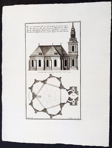
1740 Wolff & Corvinus Antique Arch. Print Jerusalem Church Friedrichstadt.Berlin
Antique Map
- Title : Die von vorgedachten Hr. von Grünenberg invendierte, unter der Direction des Hr. Ioh. Simonetti Hoff Stucator Hoch-Fürstl. Anhaltischen BauMeister aufgebaute so genande Friderich Stättische Kirche sampt dessen Grund u. Faciata.
- Ref #: 93458
- Size: 19in x 12 1/2in (490mm x 335mm)
- Date : 1740
- Condition: (A+) Fine Condition
Description:
This large rare, original copper-plate engraved antique architectural print of the Parochialkirche (literally the Reformed parochial church) in the Mitte suburb of Berlin - plate No. 7 of 16 - by Johann August Corvinus 1683 - 1738, after Andreas Mayers 1716 - 1782, was published in Eigentliche Abbildung des Prächtigen Königl. Lust Schlosses Charlottenburg, eine Meile von Berlin, sambt dem darhinden im Walde gelegenen schönen Lust Garten
(Set of 16 numbered plates, the first with the title, with plans and views of the buildings and gardens at Charlottenburg, the palace of the King of Prussia on the outskirts of Berlin.) by Jeremias Wolff Erben in 1740.
General Definitions:
Paper thickness and quality: - Heavy and stable
Paper color : - off white
Age of map color: -
Colors used: -
General color appearance: -
Paper size: - 19in x 12 1/2in (490mm x 335mm)
Plate size: - 14 1/2in x 10 1/2in (370mm x 260mm)
Margins: - Min 1in (25mm)
Imperfections:
Margins: - None
Plate area: - None
Verso: - None
Background:
Berlin straddles the banks of the River Spree, which flows into the River Havel (a tributary of the River Elbe) in the western borough of Spandau. Among the citys main topographical features are the many lakes in the western and southeastern boroughs formed by the Spree, Havel, and Dahme rivers (the largest of which is Lake Müggelsee). Due to its location in the European Plain, Berlin is influenced by a temperate seasonal climate. About one-third of the citys area is composed of forests, parks, gardens, rivers, canals and lakes. The city lies in the Central German dialect area, the Berlin dialect being a variant of the Lusatian-New Marchian dialects.
First documented in the 13th century and situated at the crossing of two important historic trade routes, Berlin became the capital of the Margraviate of Brandenburg (1417–1701), the Kingdom of Prussia (1701–1918), the German Empire (1871–1918), the Weimar Republic (1919–1933), and the Third Reich (1933–1945). Berlin in the 1920s was the third-largest municipality in the world. After World War II and its subsequent occupation by the victorious countries, the city was divided; West Berlin became a de facto West German exclave, surrounded by the Berlin Wall (1961–1989) and East German territory. East Berlin was declared capital of East Germany, while Bonn became the West German capital. Following German reunification in 1990, Berlin once again became the capital of all of Germany.
The Thirty Years War between 1618 and 1648 devastated Berlin. One third of its houses were damaged or destroyed, and the city lost half of its population. Frederick William, known as the Great Elector, who had succeeded his father George William as ruler in 1640, initiated a policy of promoting immigration and religious tolerance. With the Edict of Potsdam in 1685, Frederick William offered asylum to the French Huguenots.
By 1700, approximately 30 percent of Berlins residents were French, because of the Huguenot immigration. Many other immigrants came from Bohemia, Poland, and Salzburg.
Since 1618, the Margraviate of Brandenburg had been in personal union with the Duchy of Prussia. In 1701, the dual state formed the Kingdom of Prussia, as Frederick III, Elector of Brandenburg, crowned himself as king Frederick I in Prussia. Berlin became the capital of the new Kingdom, replacing Königsberg. This was a successful attempt to centralise the capital in the very far-flung state, and it was the first time the city began to grow. In 1709, Berlin merged with the four cities of Cölln, Friedrichswerder, Friedrichstadt and Dorotheenstadt under the name Berlin, Haupt- und Residenzstadt Berlin.
In 1740, Frederick II, known as Frederick the Great (1740–1786), came to power. Under the rule of Frederick II, Berlin became a center of the Enlightenment, but also, was briefly occupied during the Seven Years War by the Russian army. Following Frances victory in the War of the Fourth Coalition, Napoleon Bonaparte marched into Berlin in 1806, but granted self-government to the city. In 1815, the city became part of the new Province of Brandenburg.
The Industrial Revolution transformed Berlin during the 19th century; the citys economy and population expanded dramatically, and it became the main railway hub and economic centre of Germany. Additional suburbs soon developed and increased the area and population of Berlin. In 1861, neighbouring suburbs including Wedding, Moabit and several others were incorporated into Berlin. In 1871, Berlin became capital of the newly founded German Empire. In 1881, it became a city district separate from Brandenburg.
Wolff, Jeremais 1663 - 1724
Wolff was an German engraver and publisher. Born in Augsburg, he originally trained as a clock and automat maker, later changing course and opening a small copperplate engraving shop. His success was impressive and became one of the largest European art, print & map publishers in the first half of the 18th century. Wolff employed some of the best engravers of the time and although not an engraver himself, only Wolffs name was recorded on the engravings. Many of his engravers went uncredited for their work. In 1710 Wolff was one of the founder member of the Empire State Academy of Arts in Augsburg.
After his death in 1724, Wolffs publishing business was inherited by his sons and son-in-law, Johann Balthasar Probst (1673–1750) a notable engraver at the time. The firm continued on in Augsburg under the name Jeremias Wolff Erben.
Together with the Nuremberg copperplate engraver Paul Decker , Wolff published a series of engravings showing the war successes of Prince Eugene of Savoy in Italy , southern Germany and the Spanish Netherlands, during the War of the Spanish Succession . The prints are exhibited in the Museum of Military History, in Vienna .
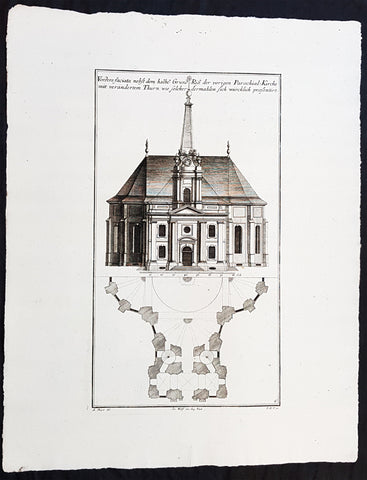
1740 Wolff & Corvinus Antique Arch. Print of the Parochialkirche in Mitte Berlin
Antique Map
- Title : Vordere faciata nebst dem halben Grund Riß der vorigen Parochial-Kirche mit verändertem Thurn wie solcher dermahlen sich würklich presentiert. Frontriß, darunter der halbe Grundriß.
- Ref #: 93459
- Size: 19in x 12 1/2in (490mm x 335mm)
- Date : 1740
- Condition: (A+) Fine Condition
Description:
This large rare, original copper-plate engraved antique architectural print of the Parochialkirche (literally the Reformed parochial church) in the Mitte suburb of Berlin - plate No. 6 of 16 - by Johann August Corvinus 1683 - 1738, after Andreas Mayers 1716 - 1782, was published in Eigentliche Abbildung des Prächtigen Königl. Lust Schlosses Charlottenburg, eine Meile von Berlin, sambt dem darhinden im Walde gelegenen schönen Lust Garten.
(Set of 16 numbered plates, the first with the title, with plans and views of the buildings and gardens at Charlottenburg, the palace of the King of Prussia on the outskirts of Berlin.) by Jeremias Wolff Erben in 1740.
General Definitions:
Paper thickness and quality: - Heavy and stable
Paper color : - off white
Age of map color: -
Colors used: -
General color appearance: -
Paper size: - 19in x 12 1/2in (490mm x 335mm)
Plate size: - 14 1/2in x 10 1/2in (370mm x 260mm)
Margins: - Min 1in (25mm)
Imperfections:
Margins: - None
Plate area: - None
Verso: - None
Background:
Berlin straddles the banks of the River Spree, which flows into the River Havel (a tributary of the River Elbe) in the western borough of Spandau. Among the citys main topographical features are the many lakes in the western and southeastern boroughs formed by the Spree, Havel, and Dahme rivers (the largest of which is Lake Müggelsee). Due to its location in the European Plain, Berlin is influenced by a temperate seasonal climate. About one-third of the citys area is composed of forests, parks, gardens, rivers, canals and lakes. The city lies in the Central German dialect area, the Berlin dialect being a variant of the Lusatian-New Marchian dialects.
First documented in the 13th century and situated at the crossing of two important historic trade routes, Berlin became the capital of the Margraviate of Brandenburg (1417–1701), the Kingdom of Prussia (1701–1918), the German Empire (1871–1918), the Weimar Republic (1919–1933), and the Third Reich (1933–1945). Berlin in the 1920s was the third-largest municipality in the world. After World War II and its subsequent occupation by the victorious countries, the city was divided; West Berlin became a de facto West German exclave, surrounded by the Berlin Wall (1961–1989) and East German territory. East Berlin was declared capital of East Germany, while Bonn became the West German capital. Following German reunification in 1990, Berlin once again became the capital of all of Germany.
The Thirty Years War between 1618 and 1648 devastated Berlin. One third of its houses were damaged or destroyed, and the city lost half of its population. Frederick William, known as the Great Elector, who had succeeded his father George William as ruler in 1640, initiated a policy of promoting immigration and religious tolerance. With the Edict of Potsdam in 1685, Frederick William offered asylum to the French Huguenots.
By 1700, approximately 30 percent of Berlins residents were French, because of the Huguenot immigration. Many other immigrants came from Bohemia, Poland, and Salzburg.
Since 1618, the Margraviate of Brandenburg had been in personal union with the Duchy of Prussia. In 1701, the dual state formed the Kingdom of Prussia, as Frederick III, Elector of Brandenburg, crowned himself as king Frederick I in Prussia. Berlin became the capital of the new Kingdom, replacing Königsberg. This was a successful attempt to centralise the capital in the very far-flung state, and it was the first time the city began to grow. In 1709, Berlin merged with the four cities of Cölln, Friedrichswerder, Friedrichstadt and Dorotheenstadt under the name Berlin, Haupt- und Residenzstadt Berlin.
In 1740, Frederick II, known as Frederick the Great (1740–1786), came to power. Under the rule of Frederick II, Berlin became a center of the Enlightenment, but also, was briefly occupied during the Seven Years War by the Russian army. Following Frances victory in the War of the Fourth Coalition, Napoleon Bonaparte marched into Berlin in 1806, but granted self-government to the city. In 1815, the city became part of the new Province of Brandenburg.
The Industrial Revolution transformed Berlin during the 19th century; the citys economy and population expanded dramatically, and it became the main railway hub and economic centre of Germany. Additional suburbs soon developed and increased the area and population of Berlin. In 1861, neighbouring suburbs including Wedding, Moabit and several others were incorporated into Berlin. In 1871, Berlin became capital of the newly founded German Empire. In 1881, it became a city district separate from Brandenburg.
Wolff, Jeremais 1663 - 1724
Wolff was an German engraver and publisher. Born in Augsburg, he originally trained as a clock and automat maker, later changing course and opening a small copperplate engraving shop. His success was impressive and became one of the largest European art, print & map publishers in the first half of the 18th century. Wolff employed some of the best engravers of the time and although not an engraver himself, only Wolffs name was recorded on the engravings. Many of his engravers went uncredited for their work. In 1710 Wolff was one of the founder member of the Empire State Academy of Arts in Augsburg.
After his death in 1724, Wolffs publishing business was inherited by his sons and son-in-law, Johann Balthasar Probst (1673–1750) a notable engraver at the time. The firm continued on in Augsburg under the name Jeremias Wolff Erben.
Together with the Nuremberg copperplate engraver Paul Decker , Wolff published a series of engravings showing the war successes of Prince Eugene of Savoy in Italy , southern Germany and the Spanish Netherlands, during the War of the Spanish Succession . The prints are exhibited in the Museum of Military History, in Vienna .
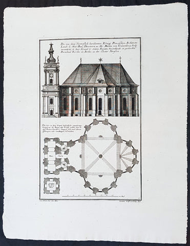
1740 Wolff & Corvinus Antique Architectural Print Parochialkirche, Mitte, Berlin
Antique Map
- Title : Die Von dem Vortreslich beruhmten Konigl. Preusichen Architect Land u. Ober Bau Directorn etc. Hr. Martin von Grunenberg Seel. inventirte, u. hier Grund u. Seiten Faciata Vorstellende so genandte Parochial Kirche in Berlin in der Closter Strassen
- Ref #: 93451
- Size: 19in x 12 1/2in (490mm x 335mm)
- Date : 1740
- Condition: (A+) Fine Condition
Description:
This large rare, original copper-plate engraved antique architectural print of the Parochialkirche (literally the Reformed parochial church) in the Mitte suburb of Berlin - plate No. 5 of 16 - by Johann August Corvinus 1683 - 1738, after Andreas Mayers 1716 - 1782, was published in Eigentliche Abbildung des Prächtigen Königl. Lust Schlosses Charlottenburg, eine Meile von Berlin, sambt dem darhinden im Walde gelegenen schönen Lust Garten
(Set of 16 numbered plates, the first with the title, with plans and views of the buildings and gardens at Charlottenburg, the palace of the King of Prussia on the outskirts of Berlin.) by Jeremias Wolff Erben in 1740.
General Definitions:
Paper thickness and quality: - Heavy and stable
Paper color : - off white
Age of map color: -
Colors used: -
General color appearance: -
Paper size: - 19in x 12 1/2in (490mm x 335mm)
Plate size: - 14 1/2in x 10 1/2in (370mm x 260mm)
Margins: - Min 1in (25mm)
Imperfections:
Margins: - None
Plate area: - None
Verso: - None
Background:
Berlin straddles the banks of the River Spree, which flows into the River Havel (a tributary of the River Elbe) in the western borough of Spandau. Among the citys main topographical features are the many lakes in the western and southeastern boroughs formed by the Spree, Havel, and Dahme rivers (the largest of which is Lake Müggelsee). Due to its location in the European Plain, Berlin is influenced by a temperate seasonal climate. About one-third of the citys area is composed of forests, parks, gardens, rivers, canals and lakes. The city lies in the Central German dialect area, the Berlin dialect being a variant of the Lusatian-New Marchian dialects.
First documented in the 13th century and situated at the crossing of two important historic trade routes, Berlin became the capital of the Margraviate of Brandenburg (1417–1701), the Kingdom of Prussia (1701–1918), the German Empire (1871–1918), the Weimar Republic (1919–1933), and the Third Reich (1933–1945). Berlin in the 1920s was the third-largest municipality in the world. After World War II and its subsequent occupation by the victorious countries, the city was divided; West Berlin became a de facto West German exclave, surrounded by the Berlin Wall (1961–1989) and East German territory. East Berlin was declared capital of East Germany, while Bonn became the West German capital. Following German reunification in 1990, Berlin once again became the capital of all of Germany.
The Thirty Years War between 1618 and 1648 devastated Berlin. One third of its houses were damaged or destroyed, and the city lost half of its population. Frederick William, known as the Great Elector, who had succeeded his father George William as ruler in 1640, initiated a policy of promoting immigration and religious tolerance. With the Edict of Potsdam in 1685, Frederick William offered asylum to the French Huguenots.
By 1700, approximately 30 percent of Berlins residents were French, because of the Huguenot immigration. Many other immigrants came from Bohemia, Poland, and Salzburg.
Since 1618, the Margraviate of Brandenburg had been in personal union with the Duchy of Prussia. In 1701, the dual state formed the Kingdom of Prussia, as Frederick III, Elector of Brandenburg, crowned himself as king Frederick I in Prussia. Berlin became the capital of the new Kingdom, replacing Königsberg. This was a successful attempt to centralise the capital in the very far-flung state, and it was the first time the city began to grow. In 1709, Berlin merged with the four cities of Cölln, Friedrichswerder, Friedrichstadt and Dorotheenstadt under the name Berlin, Haupt- und Residenzstadt Berlin.
In 1740, Frederick II, known as Frederick the Great (1740–1786), came to power. Under the rule of Frederick II, Berlin became a center of the Enlightenment, but also, was briefly occupied during the Seven Years War by the Russian army. Following Frances victory in the War of the Fourth Coalition, Napoleon Bonaparte marched into Berlin in 1806, but granted self-government to the city. In 1815, the city became part of the new Province of Brandenburg.
The Industrial Revolution transformed Berlin during the 19th century; the citys economy and population expanded dramatically, and it became the main railway hub and economic centre of Germany. Additional suburbs soon developed and increased the area and population of Berlin. In 1861, neighbouring suburbs including Wedding, Moabit and several others were incorporated into Berlin. In 1871, Berlin became capital of the newly founded German Empire. In 1881, it became a city district separate from Brandenburg.
Wolff, Jeremais 1663 - 1724
Wolff was an German engraver and publisher. Born in Augsburg, he originally trained as a clock and automat maker, later changing course and opening a small copperplate engraving shop. His success was impressive and became one of the largest European art, print & map publishers in the first half of the 18th century. Wolff employed some of the best engravers of the time and although not an engraver himself, only Wolffs name was recorded on the engravings. Many of his engravers went uncredited for their work. In 1710 Wolff was one of the founder member of the Empire State Academy of Arts in Augsburg.
After his death in 1724, Wolffs publishing business was inherited by his sons and son-in-law, Johann Balthasar Probst (1673–1750) a notable engraver at the time. The firm continued on in Augsburg under the name Jeremias Wolff Erben.
Together with the Nuremberg copperplate engraver Paul Decker , Wolff published a series of engravings showing the war successes of Prince Eugene of Savoy in Italy , southern Germany and the Spanish Netherlands, during the War of the Spanish Succession . The prints are exhibited in the Museum of Military History, in Vienna .
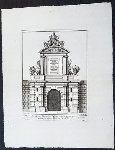
1740 Wolff & Corvinus Antique Architectural Print of Berlin Gate, Leipziger Tor
Antique Map
- Title : Das von dem Herrn Baumeister Nering Seel. ausgefuhrte so genandte Leipziger Statt Thor in Berlin
- Ref #: 93452
- Size: 19in x 12 1/2in (490mm x 335mm)
- Date : 1740
- Condition: (A+) Fine Condition
Description:
This large fine, original copper-plate engraved antique architectural print of buildings & gardens in 17th & 18th century Berlin - plate No. 3 of 16 - by Johann August Corvinus 1683 - 1738, after Andreas Mayers 1716 - 1782, was published in Eigentliche Abbildung des Prächtigen Königl. Lust Schlosses Charlottenburg, eine Meile von Berlin, sambt dem darhinden im Walde gelegenen schönen Lust Garten
(Set of 16 numbered plates, the first with the title, with plans and views of the buildings and gardens at Charlottenburg, the palace of the King of Prussia on the outskirts of Berlin.) by Jeremias Wolff Erben in 1740.
General Definitions:
Paper thickness and quality: - Heavy and stable
Paper color : - off white
Age of map color: -
Colors used: -
General color appearance: -
Paper size: - 19in x 12 1/2in (490mm x 335mm)
Plate size: - 14 1/2in x 10 1/2in (370mm x 260mm)
Margins: - Min 1in (25mm)
Imperfections:
Margins: - None
Plate area: - None
Verso: - None
Background:
Berlin straddles the banks of the River Spree, which flows into the River Havel (a tributary of the River Elbe) in the western borough of Spandau. Among the citys main topographical features are the many lakes in the western and southeastern boroughs formed by the Spree, Havel, and Dahme rivers (the largest of which is Lake Müggelsee). Due to its location in the European Plain, Berlin is influenced by a temperate seasonal climate. About one-third of the citys area is composed of forests, parks, gardens, rivers, canals and lakes. The city lies in the Central German dialect area, the Berlin dialect being a variant of the Lusatian-New Marchian dialects.
First documented in the 13th century and situated at the crossing of two important historic trade routes, Berlin became the capital of the Margraviate of Brandenburg (1417–1701), the Kingdom of Prussia (1701–1918), the German Empire (1871–1918), the Weimar Republic (1919–1933), and the Third Reich (1933–1945). Berlin in the 1920s was the third-largest municipality in the world. After World War II and its subsequent occupation by the victorious countries, the city was divided; West Berlin became a de facto West German exclave, surrounded by the Berlin Wall (1961–1989) and East German territory. East Berlin was declared capital of East Germany, while Bonn became the West German capital. Following German reunification in 1990, Berlin once again became the capital of all of Germany.
The Thirty Years War between 1618 and 1648 devastated Berlin. One third of its houses were damaged or destroyed, and the city lost half of its population. Frederick William, known as the Great Elector, who had succeeded his father George William as ruler in 1640, initiated a policy of promoting immigration and religious tolerance. With the Edict of Potsdam in 1685, Frederick William offered asylum to the French Huguenots.
By 1700, approximately 30 percent of Berlins residents were French, because of the Huguenot immigration. Many other immigrants came from Bohemia, Poland, and Salzburg.
Since 1618, the Margraviate of Brandenburg had been in personal union with the Duchy of Prussia. In 1701, the dual state formed the Kingdom of Prussia, as Frederick III, Elector of Brandenburg, crowned himself as king Frederick I in Prussia. Berlin became the capital of the new Kingdom, replacing Königsberg. This was a successful attempt to centralise the capital in the very far-flung state, and it was the first time the city began to grow. In 1709, Berlin merged with the four cities of Cölln, Friedrichswerder, Friedrichstadt and Dorotheenstadt under the name Berlin, Haupt- und Residenzstadt Berlin.
In 1740, Frederick II, known as Frederick the Great (1740–1786), came to power. Under the rule of Frederick II, Berlin became a center of the Enlightenment, but also, was briefly occupied during the Seven Years War by the Russian army. Following Frances victory in the War of the Fourth Coalition, Napoleon Bonaparte marched into Berlin in 1806, but granted self-government to the city. In 1815, the city became part of the new Province of Brandenburg.
The Industrial Revolution transformed Berlin during the 19th century; the citys economy and population expanded dramatically, and it became the main railway hub and economic centre of Germany. Additional suburbs soon developed and increased the area and population of Berlin. In 1861, neighbouring suburbs including Wedding, Moabit and several others were incorporated into Berlin. In 1871, Berlin became capital of the newly founded German Empire. In 1881, it became a city district separate from Brandenburg.
Wolff, Jeremais 1663 - 1724
Wolff was an German engraver and publisher. Born in Augsburg, he originally trained as a clock and automat maker, later changing course and opening a small copperplate engraving shop. His success was impressive and became one of the largest European art, print & map publishers in the first half of the 18th century. Wolff employed some of the best engravers of the time and although not an engraver himself, only Wolffs name was recorded on the engravings. Many of his engravers went uncredited for their work. In 1710 Wolff was one of the founder member of the Empire State Academy of Arts in Augsburg.
After his death in 1724, Wolffs publishing business was inherited by his sons and son-in-law, Johann Balthasar Probst (1673–1750) a notable engraver at the time. The firm continued on in Augsburg under the name Jeremias Wolff Erben.
Together with the Nuremberg copperplate engraver Paul Decker , Wolff published a series of engravings showing the war successes of Prince Eugene of Savoy in Italy , southern Germany and the Spanish Netherlands, during the War of the Spanish Succession . The prints are exhibited in the Museum of Military History, in Vienna .
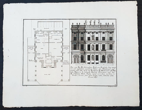
1740 Wolff & Corvinus Antique Architectural Print Buildings, Gardens Berlin - No. 14
Antique Map
- Title : Das von Title Hr. Geheimbten Rath von Krossecks Seel. inventirt - und aussgebaute
- Ref #: 93448
- Size: 19in x 12 1/2in (490mm x 335mm)
- Date : 1740
- Condition: (A+) Fine Condition
Description:
This large fine, original copper-plate engraved antique architectural print of buildings & gardens in the Charlottenburg suburb of Berlin & Charlottenburg Palace, - plate No. 14 of 16 - by Johann August Corvinus 1683 - 1738, after Andreas Mayers 1716 - 1782, was published in Eigentliche Abbildung des Prächtigen Königl. Lust Schlosses Charlottenburg, eine Meile von Berlin, sambt dem darhinden im Walde gelegenen schönen Lust Garten
(Set of 16 numbered plates, the first with the title, with plans and views of the buildings and gardens at Charlottenburg, the palace of the King of Prussia on the outskirts of Berlin.) by Jeremias Wolff Erben in 1740.
General Definitions:
Paper thickness and quality: - Heavy and stable
Paper color : - off white
Age of map color: -
Colors used: -
General color appearance: -
Paper size: - 19in x 12 1/2in (490mm x 335mm)
Plate size: - 14 1/2in x 10 1/2in (370mm x 260mm)
Margins: - Min 1in (25mm)
Imperfections:
Margins: - None
Plate area: - None
Verso: - None
Background:
Charlottenburg is an affluent locality of Berlin within the borough of Charlottenburg-Wilmersdorf. Established as a town in 1705 and named after late Sophia Charlotte of Hanover, Queen consort of Prussia, it is best known for Charlottenburg Palace, the largest surviving royal palace in Berlin, and the adjacent museums.
Charlottenburg is located in Berlins inner city, west of the Großer Tiergarten park. Its historic core, the former village green of Alt Lietzow, is situated on the southern shore of the Spree River running through the Berlin glacial valley. The Straße des 17. Juni road, former Charlottenburger Chaussee, which runs eastwards from Charlottenburg Gate through the Tiergarten park to Brandenburg Gate, connects Charlottenburg with the historic centre of Berlin-Mitte.
In the north and west, the Berlin Ringbahn and the Bundesautobahn 100 (Stadtring) mark the border with the Charlottenburg-Nord and Westend suburbs. Adjacent in the south is the territory of Wilmersdorf. Charlottenburg also borders on the district of Halensee in the southwest, as well as on Moabit, Hansaviertel and Tiergarten (all part of the Mitte borough) in the east and on Schöneberg in the southeast.
In 1695, Sophia Charlotte of Hanover received Lietzow from her husband, Elector Frederick III of Brandenburg, in exchange for her estates in Caputh and Langerwisch near Potsdam. Frederick had a summer residence built there for Sophie Charlotte by the architect Johann Arnold Nering between 1695 and 1699. After he had crowned himself Frederick I, King in Prussia, the Lützenburg castle was extended into a stately building with a cour dhonneur. The Swedish master builder Johann Friedrich Eosander supervised this work. Sophie Charlotte died in February 1705; shortly afterwards the settlement facing the palace was called Charlottenburg - the palace itself became Schloss Charlottenburg - and chartered as a town on April 5, 1705. The king served as the towns mayor until the historic village of Lietzow was incorporated into Charlottenburg in 1720.
Fredericks successor as king, Frederick William I of Prussia, rarely stayed at the palace, which depressed the small town of Charlottenburg. Frederick William even tried to revoke the towns privileges. With the coronation of his successor Frederick II in 1740 the towns significance increased, as regular celebrations again took place at the palace. Between 1740 and 1747 Georg Wenzeslaus von Knobelsdorff built the eastern New Wing as Fredericks residence. Later, Frederick II preferred the palace of Sanssouci, which he had partly designed himself.
When Frederick II died in 1786, his nephew Frederick William II succeeded him, and Charlottenburg became the favourite royal residence, and remained so for his son and successor Frederick William III (reigned 1797-1840). After the defeat of the Prussian army at Jena in 1806, the French occupied Berlin. Napoleon took over the palace, while his troops made a camp nearby. Charlottenburg became part of the new Prussian Province of Brandenburg in 1815 after the Napoleonic Wars.
In the late 18th century, Charlottenburgs development did not depend only on the crown. The town became a recreational area for the expanding city of Berlin. Its first true inn opened in the 1770s, in the street then called Berliner Straße (now Otto-Suhr-Allee), and many other inns and beer gardens were to follow, popular for weekend parties especially. Berliners seeking leisure and entertainment came by boat, by carriage and later by horse-drawn trams, above all to a large amusement park at the shore of the Spree river called Flora, that went into bankruptcy in 1904.
From the 1860s on the wealthy Bourgeoisie of Berlin discovered Charlottenburg as a residential area, among the first were Gerson von Bleichröder and Ernst Werner von Siemens, who had a villa built in the Berliner Straße in 1862. At the same time industrial companies like Siemens & Halske and Schering erected large factories in the north-east, at the border with the Moabit district of Berlin. In 1877 Charlottenburg received town privileges and until World War I saw an enormous increase of population with 100,000 inhabitants as of 1893 and a population of 306,000 in 1920, being the second largest city within the Province of Brandenburg, after Berlin. In the course of industrialization in the 19th century, much of Charlottenburg was incorporated in a network of streets laid out in the Hobrecht-Plan in an area that came to be known architecturally as the Wilhelmine Ring.
Wolff, Jeremais 1663 - 1724
Wolff was an German engraver and publisher. Born in Augsburg, he originally trained as a clock and automat maker, later changing course and opening a small copperplate engraving shop. His success was impressive and became one of the largest European art, print & map publishers in the first half of the 18th century. Wolff employed some of the best engravers of the time and although not an engraver himself, only Wolffs name was recorded on the engravings. Many of his engravers went uncredited for their work. In 1710 Wolff was one of the founder member of the Empire State Academy of Arts in Augsburg.
After his death in 1724, Wolffs publishing business was inherited by his sons and son-in-law, Johann Balthasar Probst (1673–1750) a notable engraver at the time. The firm continued on in Augsburg under the name Jeremias Wolff Erben.
Together with the Nuremberg copperplate engraver Paul Decker , Wolff published a series of engravings showing the war successes of Prince Eugene of Savoy in Italy , southern Germany and the Spanish Netherlands, during the War of the Spanish Succession . The prints are exhibited in the Museum of Military History, in Vienna .
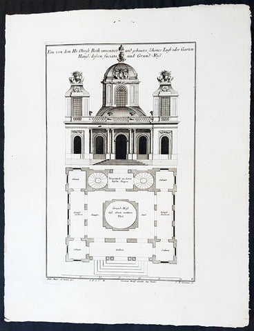
1740 Wolff & Corvinus Antique Architectural Print Charlottenburg Palace, Gardens
Antique Map
- Title : Haupt Hof Grund Riss dess Marstalls...Jeremais Wolff exc Aug. Vind
- Ref #: 93446
- Size: 19in x 12 1/2in (490mm x 335mm)
- Date : 1740
- Condition: (A+) Fine Condition
Description:
This large fine, original copper-plate engraved antique architectural print of buildings in the Charlottenburg suburb of Berlin & Charlottenburg Palace, - plate No. 4 of 16 - by Johann August Corvinus 1683 - 1738, after Andreas Mayers 1716 - 1782, was published in Eigentliche Abbildung des Prächtigen Königl. Lust Schlosses Charlottenburg, eine Meile von Berlin, sambt dem darhinden im Walde gelegenen schönen Lust Garten
(Set of 16 numbered plates, the first with the title, with plans and views of the buildings and gardens at Charlottenburg, the palace of the King of Prussia on the outskirts of Berlin.) by Jeremias Wolff Erben in 1740.
General Definitions:
Paper thickness and quality: - Heavy and stable
Paper color : - off white
Age of map color: -
Colors used: -
General color appearance: -
Paper size: - 19in x 12 1/2in (490mm x 335mm)
Plate size: - 15 1/2in x 10in (385mm x 255mm)
Margins: - Min 1in (25mm)
Imperfections:
Margins: - None
Plate area: - None
Verso: - None
Background:
Charlottenburg is an affluent locality of Berlin within the borough of Charlottenburg-Wilmersdorf. Established as a town in 1705 and named after late Sophia Charlotte of Hanover, Queen consort of Prussia, it is best known for Charlottenburg Palace, the largest surviving royal palace in Berlin, and the adjacent museums.
Charlottenburg is located in Berlins inner city, west of the Großer Tiergarten park. Its historic core, the former village green of Alt Lietzow, is situated on the southern shore of the Spree River running through the Berlin glacial valley. The Straße des 17. Juni road, former Charlottenburger Chaussee, which runs eastwards from Charlottenburg Gate through the Tiergarten park to Brandenburg Gate, connects Charlottenburg with the historic centre of Berlin-Mitte.
In the north and west, the Berlin Ringbahn and the Bundesautobahn 100 (Stadtring) mark the border with the Charlottenburg-Nord and Westend suburbs. Adjacent in the south is the territory of Wilmersdorf. Charlottenburg also borders on the district of Halensee in the southwest, as well as on Moabit, Hansaviertel and Tiergarten (all part of the Mitte borough) in the east and on Schöneberg in the southeast.
In 1695, Sophia Charlotte of Hanover received Lietzow from her husband, Elector Frederick III of Brandenburg, in exchange for her estates in Caputh and Langerwisch near Potsdam. Frederick had a summer residence built there for Sophie Charlotte by the architect Johann Arnold Nering between 1695 and 1699. After he had crowned himself Frederick I, King in Prussia, the Lützenburg castle was extended into a stately building with a cour dhonneur. The Swedish master builder Johann Friedrich Eosander supervised this work. Sophie Charlotte died in February 1705; shortly afterwards the settlement facing the palace was called Charlottenburg - the palace itself became Schloss Charlottenburg - and chartered as a town on April 5, 1705. The king served as the towns mayor until the historic village of Lietzow was incorporated into Charlottenburg in 1720.
Fredericks successor as king, Frederick William I of Prussia, rarely stayed at the palace, which depressed the small town of Charlottenburg. Frederick William even tried to revoke the towns privileges. With the coronation of his successor Frederick II in 1740 the towns significance increased, as regular celebrations again took place at the palace. Between 1740 and 1747 Georg Wenzeslaus von Knobelsdorff built the eastern New Wing as Fredericks residence. Later, Frederick II preferred the palace of Sanssouci, which he had partly designed himself.
When Frederick II died in 1786, his nephew Frederick William II succeeded him, and Charlottenburg became the favourite royal residence, and remained so for his son and successor Frederick William III (reigned 1797-1840). After the defeat of the Prussian army at Jena in 1806, the French occupied Berlin. Napoleon took over the palace, while his troops made a camp nearby. Charlottenburg became part of the new Prussian Province of Brandenburg in 1815 after the Napoleonic Wars.
In the late 18th century, Charlottenburgs development did not depend only on the crown. The town became a recreational area for the expanding city of Berlin. Its first true inn opened in the 1770s, in the street then called Berliner Straße (now Otto-Suhr-Allee), and many other inns and beer gardens were to follow, popular for weekend parties especially. Berliners seeking leisure and entertainment came by boat, by carriage and later by horse-drawn trams, above all to a large amusement park at the shore of the Spree river called Flora, that went into bankruptcy in 1904.
From the 1860s on the wealthy Bourgeoisie of Berlin discovered Charlottenburg as a residential area, among the first were Gerson von Bleichröder and Ernst Werner von Siemens, who had a villa built in the Berliner Straße in 1862. At the same time industrial companies like Siemens & Halske and Schering erected large factories in the north-east, at the border with the Moabit district of Berlin. In 1877 Charlottenburg received town privileges and until World War I saw an enormous increase of population with 100,000 inhabitants as of 1893 and a population of 306,000 in 1920, being the second largest city within the Province of Brandenburg, after Berlin. In the course of industrialization in the 19th century, much of Charlottenburg was incorporated in a network of streets laid out in the Hobrecht-Plan in an area that came to be known architecturally as the Wilhelmine Ring.
Wolff, Jeremais 1663 - 1724
Wolff was an German engraver and publisher. Born in Augsburg, he originally trained as a clock and automat maker, later changing course and opening a small copperplate engraving shop. His success was impressive and became one of the largest European art, print & map publishers in the first half of the 18th century. Wolff employed some of the best engravers of the time and although not an engraver himself, only Wolffs name was recorded on the engravings. Many of his engravers went uncredited for their work. In 1710 Wolff was one of the founder member of the Empire State Academy of Arts in Augsburg.
After his death in 1724, Wolffs publishing business was inherited by his sons and son-in-law, Johann Balthasar Probst (1673–1750) a notable engraver at the time. The firm continued on in Augsburg under the name Jeremias Wolff Erben.
Together with the Nuremberg copperplate engraver Paul Decker , Wolff published a series of engravings showing the war successes of Prince Eugene of Savoy in Italy , southern Germany and the Spanish Netherlands, during the War of the Spanish Succession . The prints are exhibited in the Museum of Military History, in Vienna .
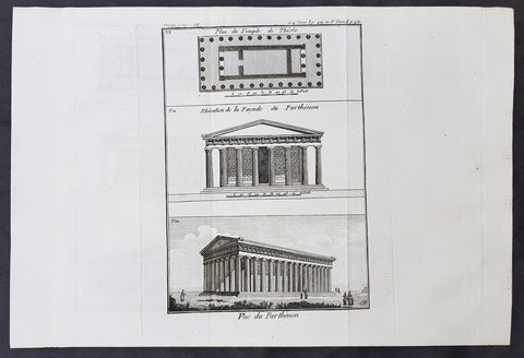
1787 Du Bocage & Barthelemy Antique Views & Plan of The Parthenon, Athens Greece
- Title : Plan du Temple de Thesee; Elevation de la Facade du Parthenon; Vue du Parthenon
- Size: 15in x 10in (380mm x 255mm)
- Ref #: 16458
- Date : 1787
- Condition: (A+) Fine Condition
Description:
This original copper-plate engraved print by Jean Denis Barbie du Bocage was was published in the 1787 edition of Jean-Jacques Barthelemy famous Voyage du jeune Anarcharsis en Grece or Travels of Anacharsis the younger in Greece in 4 volumes.
General Definitions:
Paper thickness and quality: - Heavy and stable
Paper color : - off white
Age of map color: -
Colors used: -
General color appearance: -
Paper size: - 15in x 10in (380mm x 255mm)
Plate size: - 9 1/2in x 7in (240mm x 180mm)
Margins: - Min 1in (25mm)
Imperfections:
Margins: - None
Plate area: - Folds as issued
Verso: - None
Background:
Jean-Jacques Barthelemy 1716 – 1795 was a French writer and numismatist.
Barthelemy was the author of a number of learned works on antiquarian subjects, but the great work on which his fame rests is Travels of Anacharsis the younger in Greece (French: Voyage du jeune Anarcharsis en Grece, 4 vols., 1787). He had begun it in 1757 and had been working on it for thirty years. The hero, a young Scythian descended from the famous philosopher Anacharsis, is supposed to repair to Greece for instruction in his early youth, and after making the tour of her republics, colonies and islands, to return to his native country and write this book in his old age, after the Macedonian hero had overturned the Persian empire. In the manner of modern travellers, he gives an account of the customs, government, and antiquities of the country he is supposed to have visited. A copious introduction supplies whatever may be wanting in respect to historical details, while various dissertations on the music of the Greeks, on the literature of the Athenians, and on the economy, pursuits, ruling passions, manners, and customs of the surrounding states supply ample information on the subjects of which they treat.
Modern scholarship has superseded most of the details in the Voyage, but the author himself did not imagine his book to be a register of accurately ascertained facts. Rather, he intended to afford to his countrymen, in an interesting form, some knowledge of Greek civilisation. The Charicles, or Illustrations of the Private Life of the Ancient Greeks of Wilhelm Adolf Becker is an attempt in a similar direction
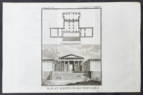
1787 Du Bocage & Barthelemy Antique Print & Plan of a Greek Propylaea or Gateway
- Title : Plan et Elevation des Propylees
- Size: 15in x 10in (380mm x 255mm)
- Ref #: 16459
- Date : 1787
- Condition: (A+) Fine Condition
Description:
This original copper-plate engraved print by Jean Denis Barbie du Bocage was was published in the 1787 edition of Jean-Jacques Barthelemy famous Voyage du jeune Anarcharsis en Grece or Travels of Anacharsis the younger in Greece in 4 volumes.
General Definitions:
Paper thickness and quality: - Heavy and stable
Paper color : - off white
Age of map color: -
Colors used: -
General color appearance: -
Paper size: - 15in x 10in (380mm x 255mm)
Plate size: - 9 1/2in x 7in (240mm x 180mm)
Margins: - Min 1in (25mm)
Imperfections:
Margins: - None
Plate area: - Folds as issued
Verso: - None
Background:
Jean-Jacques Barthelemy 1716 – 1795 was a French writer and numismatist.
Barthelemy was the author of a number of learned works on antiquarian subjects, but the great work on which his fame rests is Travels of Anacharsis the younger in Greece (French: Voyage du jeune Anarcharsis en Grece, 4 vols., 1787). He had begun it in 1757 and had been working on it for thirty years. The hero, a young Scythian descended from the famous philosopher Anacharsis, is supposed to repair to Greece for instruction in his early youth, and after making the tour of her republics, colonies and islands, to return to his native country and write this book in his old age, after the Macedonian hero had overturned the Persian empire. In the manner of modern travellers, he gives an account of the customs, government, and antiquities of the country he is supposed to have visited. A copious introduction supplies whatever may be wanting in respect to historical details, while various dissertations on the music of the Greeks, on the literature of the Athenians, and on the economy, pursuits, ruling passions, manners, and customs of the surrounding states supply ample information on the subjects of which they treat.
Modern scholarship has superseded most of the details in the Voyage, but the author himself did not imagine his book to be a register of accurately ascertained facts. Rather, he intended to afford to his countrymen, in an interesting form, some knowledge of Greek civilisation. The Charicles, or Illustrations of the Private Life of the Ancient Greeks of Wilhelm Adolf Becker is an attempt in a similar direction
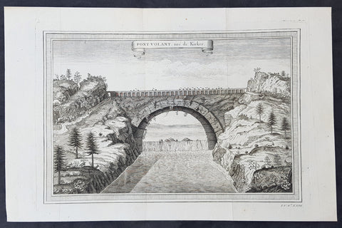
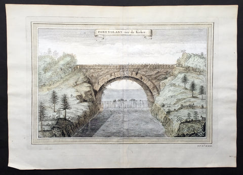
1750 Prevost, after Kircher, Antique Print Bridge over Yellow River, Xensi China
- Title : Pont Volant, tire de Kirker
- Size: 14 1/2in x 9 1/2in (370mm x 240mm)
- Ref #: 16097
- Date : 1750
- Condition: (A+) Fine Condition
Description:
This fine original copper-plate engraved antique print a view of a single Arch Bridge over the Yellow River in Xensi Province near Chogan was engraved by Jakob van Schley -
after Athanasius Kirchers China Illustrated - was published in Antoine François Prevosts 15 volumes of Histoire Generale des Voyageswritten by Prevost & other authors between 1746-1790.
Athanasius Kircher, S.J. sometimes erroneously spelled Kirchner; Latin: Athanasius Kircherus, 1602 – 1680 was a German Jesuit scholar and polymath who published around 40 major works, most notably in the fields of comparative religion, geology, and medicine. Kircher has been compared to fellow Jesuit Roger Boscovich and to Leonardo da Vinci for his enormous range of interests, and has been honored with the title \"Master of a Hundred Arts\". He taught for more than forty years at the Roman College, where he set up a wunderkammer. A resurgence of interest in Kircher has occurred within the scholarly community in recent decades.
Kircher claimed to have deciphered the hieroglyphic writing of the ancient Egyptian language, but most of his assumptions and translations in this field were later found to be nonsensical. He did, however, correctly establish the link between the ancient Egyptian and the Coptic languages, and some commentators regard him as the founder of Egyptology. Kircher was also fascinated with Sinology and wrote an encyclopedia of China, in which he noted the early presence there of Nestorian Christians while also attempting to establish links with Egypt and Christianity.
Kircher had an early interest in China, telling his superior in 1629 that he wished to become a missionary to that country. In 1667 he published a treatise whose full title was China monumentis, qua sacris qua profanis, nec non variis naturae & artis spectaculis, aliarumque rerum memorabilium argumentis illustrata, and which is commonly known simply as China Illustrata, i.e. \"China Illustrated\". It was a work of encyclopedic breadth, combining material of unequal quality, from accurate cartography to mythical elements, such as a study of dragons. The work drew heavily on the reports of Jesuits working in China, in particular Michael Boymand Martino Martini.
China Illustrata emphasized the Christian elements of Chinese history, both real and imagined: the book noted the early presence of Nestorian Christians (with a Latin translation of the Nestorian Stele of Xi\'an provided by Boym and his Chinese collaborator, Andrew Zheng) but also claimed that the Chinese were descended from the sons of Ham, that Confucius was Hermes Trismegistus/Moses and that the Chinese characters were abstracted hieroglyphs.
In Kircher\'s system, ideograms were inferior to hieroglyphs because they referred to specific ideas rather than to mysterious complexes of ideas, while the signs of the Maya and Aztecs were yet lower pictograms which referred only to objects. Umberto Eco comments that this idea reflected and supported the ethnocentric European attitude toward Chinese and native American civilizations;
\"China was presented not as an unknown barbarian to be defeated but as a prodigal son who should return to the home of the common father\"
General Definitions:
Paper thickness and quality: - Heavy and stable
Paper color : - off white
Age of map color: -
Colors used: -
General color appearance: -
Paper size: - 14 1/2in x 9 1/2in (370mm x 240mm)
Plate size: - 12in x 8in (305mm x 205mm)
Margins: - Min 1/2in (12mm)
Imperfections:
Margins: - None
Plate area: - None
Verso: - None
Background:
One of Antoine Francois Prevosts monumental undertakings was his history of exploration & discovery in 15 volumes titledHistoire Générale des Voyages written between 1746-1759 and was extended to 20 volumes after his death by various authors.
The 20 volumes cover the early explorations & discoveries on 3 continents: Africa (v. 1-5), Asia (v. 5-11), and America (v. 12-15) with material on the finding of the French, English, Dutch, and Portugese.
A number of notable cartographers and engravers contributed to the copper plate maps and views to the 20 volumes including Nicolas Bellin, Jan Schley, Chedel, Franc Aveline, Fessard, and many others.
The African volumes cover primarily coastal countries of West, Southern, and Eastern Africa, plus the Congo, Madagascar, Arabia and the Persian Gulf areas.
The Asian volumes cover China, Korea, Tibet, Japan, Philippines, and countries bordering the Indian Ocean.
Volume 11 includes Australia and Antarctica.
Volumes 12-15 cover voyages and discoveries in America, including the East Indies, South, Central and North America.
Volumes 16-20 include supplement volumes & tables along with continuation of voyages and discoveries in Russia, Northern Europe, America, Asia & Australia.
Jakob van der Schley aka Jakob van Schley (1715 - 1779) was a Dutch draughtsman and engraver. He studied under Bernard Picart (1673-1733) whose style he subsequently copied. His main interests were engraving portraits and producing illustrations for \"La Vie de Marianne\" by Pierre Carlet de Chamblain de Marivaux (1688-1763) published in The Hague between 1735 and 1747.
He also engraved the frontispieces for a 15-volume edition of the complete works of Pierre de Brantôme (1540-1614), \"Oeuvres du seigneur de Brantôme\", published in The Hague in 1740.
He is also responsible for most of the plates in the Hague edition of Prévost\'s Histoire générale des voyages. (Ref: Tooley; M&B)
1750 Prevost, after Kircher, Antique Print Bridge over Yellow River, Xensi China
- Title : Pont Volant, tire de Kirker
- Size: 14 1/2in x 9 1/2in (370mm x 240mm)
- Ref #: 25694
- Date : 1750
- Condition: (A+) Fine Condition
Description:
This fine original copper-plate engraved antique print a view of a single Arch Bridge over the Yellow River in Xensi Province near Chogan was engraved by Jakob van Schley -
after Athanasius Kirchers China Illustrated - was published in Antoine François Prevosts 15 volumes of Histoire Generale des Voyageswritten by Prevost & other authors between 1746-1790.
Athanasius Kircher, S.J. sometimes erroneously spelled Kirchner; Latin: Athanasius Kircherus, 1602 – 1680 was a German Jesuit scholar and polymath who published around 40 major works, most notably in the fields of comparative religion, geology, and medicine. Kircher has been compared to fellow Jesuit Roger Boscovich and to Leonardo da Vinci for his enormous range of interests, and has been honored with the title \"Master of a Hundred Arts\". He taught for more than forty years at the Roman College, where he set up a wunderkammer. A resurgence of interest in Kircher has occurred within the scholarly community in recent decades.
Kircher claimed to have deciphered the hieroglyphic writing of the ancient Egyptian language, but most of his assumptions and translations in this field were later found to be nonsensical. He did, however, correctly establish the link between the ancient Egyptian and the Coptic languages, and some commentators regard him as the founder of Egyptology. Kircher was also fascinated with Sinology and wrote an encyclopedia of China, in which he noted the early presence there of Nestorian Christians while also attempting to establish links with Egypt and Christianity.
Kircher had an early interest in China, telling his superior in 1629 that he wished to become a missionary to that country. In 1667 he published a treatise whose full title was China monumentis, qua sacris qua profanis, nec non variis naturae & artis spectaculis, aliarumque rerum memorabilium argumentis illustrata, and which is commonly known simply as China Illustrata, i.e. \"China Illustrated\". It was a work of encyclopedic breadth, combining material of unequal quality, from accurate cartography to mythical elements, such as a study of dragons. The work drew heavily on the reports of Jesuits working in China, in particular Michael Boymand Martino Martini.
China Illustrata emphasized the Christian elements of Chinese history, both real and imagined: the book noted the early presence of Nestorian Christians (with a Latin translation of the Nestorian Stele of Xi\'an provided by Boym and his Chinese collaborator, Andrew Zheng) but also claimed that the Chinese were descended from the sons of Ham, that Confucius was Hermes Trismegistus/Moses and that the Chinese characters were abstracted hieroglyphs.
In Kircher\'s system, ideograms were inferior to hieroglyphs because they referred to specific ideas rather than to mysterious complexes of ideas, while the signs of the Maya and Aztecs were yet lower pictograms which referred only to objects. Umberto Eco comments that this idea reflected and supported the ethnocentric European attitude toward Chinese and native American civilizations;
\"China was presented not as an unknown barbarian to be defeated but as a prodigal son who should return to the home of the common father\"
General Definitions:
Paper thickness and quality: - Heavy and stable
Paper color : - off white
Age of map color: - Early
Colors used: - Yellow, green, pink
General color appearance: - Authentic
Paper size: - 14 1/2in x 9 1/2in (370mm x 240mm)
Plate size: - 12in x 8in (305mm x 205mm)
Margins: - Min 1/2in (12mm)
Imperfections:
Margins: - None
Plate area: - None
Verso: - None
Background:
One of Antoine Francois Prevosts monumental undertakings was his history of exploration & discovery in 15 volumes titledHistoire Générale des Voyages written between 1746-1759 and was extended to 20 volumes after his death by various authors.
The 20 volumes cover the early explorations & discoveries on 3 continents: Africa (v. 1-5), Asia (v. 5-11), and America (v. 12-15) with material on the finding of the French, English, Dutch, and Portugese.
A number of notable cartographers and engravers contributed to the copper plate maps and views to the 20 volumes including Nicolas Bellin, Jan Schley, Chedel, Franc Aveline, Fessard, and many others.
The African volumes cover primarily coastal countries of West, Southern, and Eastern Africa, plus the Congo, Madagascar, Arabia and the Persian Gulf areas.
The Asian volumes cover China, Korea, Tibet, Japan, Philippines, and countries bordering the Indian Ocean.
Volume 11 includes Australia and Antarctica.
Volumes 12-15 cover voyages and discoveries in America, including the East Indies, South, Central and North America.
Volumes 16-20 include supplement volumes & tables along with continuation of voyages and discoveries in Russia, Northern Europe, America, Asia & Australia.
Jakob van der Schley aka Jakob van Schley (1715 - 1779) was a Dutch draughtsman and engraver. He studied under Bernard Picart (1673-1733) whose style he subsequently copied. His main interests were engraving portraits and producing illustrations for \"La Vie de Marianne\" by Pierre Carlet de Chamblain de Marivaux (1688-1763) published in The Hague between 1735 and 1747.
He also engraved the frontispieces for a 15-volume edition of the complete works of Pierre de Brantôme (1540-1614), \"Oeuvres du seigneur de Brantôme\", published in The Hague in 1740.
He is also responsible for most of the plates in the Hague edition of Prévost\'s Histoire générale des voyages. (Ref: Tooley; M&B)
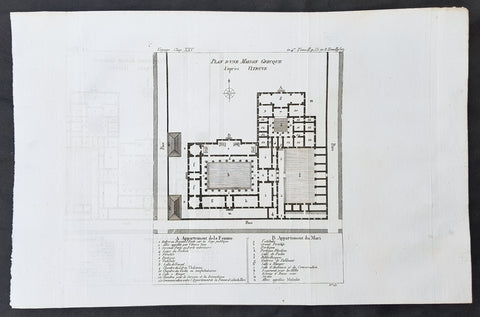
1787 Du Bocage & Barthelemy Antique Plan & Legend of a Greek Mansion by Vitruvius
- Title : Plan D une Maison Grecque d apres Vitruve
- Size: 15in x 10in (380mm x 255mm)
- Ref #: 16455
- Date : 1787
- Condition: (A+) Fine Condition
Description:
This original copper-plate engraved print by Jean Denis Barbie du Bocage was was published in the 1787 edition of Jean-Jacques Barthelemy famous Voyage du jeune Anarcharsis en Grece or Travels of Anacharsis the younger in Greece in 4 volumes.
General Definitions:
Paper thickness and quality: - Heavy and stable
Paper color : - off white
Age of map color: -
Colors used: -
General color appearance: -
Paper size: - 15in x 10in (380mm x 255mm)
Plate size: - 9 1/2in x 7in (240mm x 180mm)
Margins: - Min 1in (25mm)
Imperfections:
Margins: - None
Plate area: - Folds as issued
Verso: - None
Background:
Jean-Jacques Barthelemy 1716 – 1795 was a French writer and numismatist.
Barthelemy was the author of a number of learned works on antiquarian subjects, but the great work on which his fame rests is Travels of Anacharsis the younger in Greece (French: Voyage du jeune Anarcharsis en Grece, 4 vols., 1787). He had begun it in 1757 and had been working on it for thirty years. The hero, a young Scythian descended from the famous philosopher Anacharsis, is supposed to repair to Greece for instruction in his early youth, and after making the tour of her republics, colonies and islands, to return to his native country and write this book in his old age, after the Macedonian hero had overturned the Persian empire. In the manner of modern travellers, he gives an account of the customs, government, and antiquities of the country he is supposed to have visited. A copious introduction supplies whatever may be wanting in respect to historical details, while various dissertations on the music of the Greeks, on the literature of the Athenians, and on the economy, pursuits, ruling passions, manners, and customs of the surrounding states supply ample information on the subjects of which they treat.
Modern scholarship has superseded most of the details in the Voyage, but the author himself did not imagine his book to be a register of accurately ascertained facts. Rather, he intended to afford to his countrymen, in an interesting form, some knowledge of Greek civilisation. The Charicles, or Illustrations of the Private Life of the Ancient Greeks of Wilhelm Adolf Becker is an attempt in a similar direction
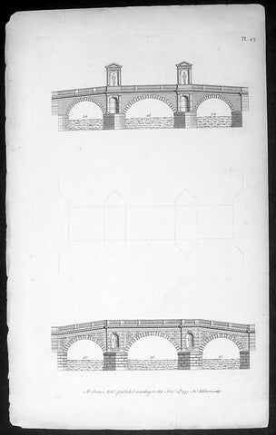
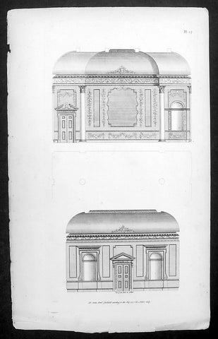
1757 Abraham Swan Antique Architect Print of Ornate 18th century Bridges
- Title : Ab. Swan Archt. Published aaccording to Act Nov 14th 1757. In. Addison Sculpt.
- Date : 1757
- Condition: (A) Very Good Condition
- Ref: 70539
- Size: 15 1/2in x 10in (395mm x 255mm)
Description:
This fine original antique print of two interior architectural designs by the 18th century architect Abraham Swan was engraved by Thomas Miller in 1757 - the date is engraved at the foot of the print - and was published in Swans A collection of designs in architecture : containing new plans and elevations of houses, for general use. 1757(Ref: M&B; Tooley)
General Description:
Paper thickness and quality: - Heavy & stable
Paper color: - White
Age of map color: -
Colors used: -
General color appearance: -
Paper size: - 15 1/2in x 10in (395mm x 255mm)
Plate size: - 14in x 8in (355mm x 205mm)
Margins: - Min 1/2in (12mm)
Imperfections:
Margins: - None
Plate area: - None
Verso: - None
1757 Abraham Swan Large Antique Print of 18th century Architect Design
- Title : Ab. Swan Archt. Published aaccording to Act July 1757. Thomas Miller Sculpt.
- Date : 1757
- Condition: (A+) Fine Condition
- Ref: 70538
- Size: 15 1/2in x 10in (395mm x 255mm)
Description:
This fine original antique print of two interior architectural designs by the 18th century architect Abraham Swan was engraved by Thomas Miller in 1757 - the date is engraved at the foot of the print - and was published in Swans A collection of designs in architecture : containing new plans and elevations of houses, for general use. 1757(Ref: M&B; Tooley)
General Description:
Paper thickness and quality: - Heavy & stable
Paper color: - White
Age of map color: -
Colors used: -
General color appearance: -
Paper size: - 15 1/2in x 10in (395mm x 255mm)
Plate size: - 14in x 8in (355mm x 205mm)
Margins: - Min 1/2in (12mm)
Imperfections:
Margins: - None
Plate area: - None
Verso: - None
1665 De Rossi Original Antique Architectural Plan, Print of Santo Spirito Palace Florence
- Title : Pianta Del Palazzo Di Santo Spirito
- Date : 1665
- Condition: (A+) Fine Condition
- Ref: 91193
- Size: 18in x 14in (460mm x 360mm)
Description:
This finely engraved original antique architectural print of Palace Santo Spirito in the Oltrarno quarter of Florence, Italy by Giovanni Battistaa Falda was published by Giacomo de Rossi in the 1665 edition of Il nuovo teatro delle fabriche, et edificii, in prospettiva di Roma moderna, 1665-1699.
These original prints are published on beautiful heavy clean original 17th century laid Italian made paper.
General Definitions:
Paper thickness and quality: - Heavy and stable
Paper color : - off white
Age of map color: -
Colors used: -
General color appearance: -
Paper size: - 18in x 14in (460mm x 360mm)
Plate size: - 11 1/2in x 9in (290mm x 230mm)
Margins: - Min 1/2in (12mm)
Imperfections:
Margins: - None
Plate area: - None
Verso: - None
Background:
Il Nuovo Teatro: One of the most important architectural projects of the seventeenth century was the urban renovation of Rome. Under the brilliant leadership of Pope Alessandro VII (1655-1667), Rome dramatically emerged as one of the most modern and beautiful cities of the new Baroque age. Within several decades spacious roadways were constructed, monumental buildings arose, and many public squares appeared with elaborate fountains and monuments. To be sure, this massive undertaking was meant to underline the absolute power of the Papacy but it also brought forth a new flowering of Italian art and architecture.
The Nuovo Teatro was initiated in 1665 to depict the new Rome in a series of etchings. What it gave to future generations was a magnificent historical record of views etched by two of Italy's greatest architectural artists. The printing and publishing of these important etchings was entrusted to Giacomo de Rossi (1626-1691), the head of the most dominant Roman publishing house. Sons and nephews of de Rossi, in fact, continued the publishing house until 1738 when the business was sold to Pope Clement XII to form the basis of the Regia Calcografia.) Altogether, four sets of Nuovo Teatro were created during the seventeenth century. Volumes one (35 etchings) and two (17 etchings) were both published in the year of 1665 and dealt mainly in views of the new piazzas, gardens, terraces and their surrounding buildings. Volume 3 (38 etchings) was published in 1669 and concentrated upon the newly constructed churches of Rome. Every plate from the first three sets was both designed and etched by the influential architectural artist, Giovanni Battista Falda (1643-1678). For reasons unknown the fourth and final volume (52 etchings) did not appear until 1699. It was published by Giacomo's successor, Domenico de Rossi, and featured views of the palaces and stately homes of Rome. Each plate was designed and etched by the famous architect and etcher, Alessandro Specchi (1668-1729)
1665 De Rossi Original Antique Architectural Plan, Print of Millini Palace, Rome, Italy
- Title : Pianta Del Palazzo De Sig. Mellini
- Date : 1665
- Condition: (A+) Fine Condition
- Ref: 91194
- Size: 18in x 14in (460mm x 360mm)
Description:
This finely engraved original antique architectural engraving a plan of the Palace owned by the Mellini or Millini family in Rome, Italy by Giovanni Battistaa Falda was published by Giacomo de Rossi in the 1665 edition of Il nuovo teatro delle fabriche, et edificii, in prospettiva di Roma moderna, 1665-1699.
These original prints are published on beautiful heavy clean original 17th century laid Italian made paper.
General Definitions:
Paper thickness and quality: - Heavy and stable
Paper color : - off white
Age of map color: -
Colors used: -
General color appearance: -
Paper size: - 18in x 14in (460mm x 360mm)
Plate size: - 11 1/2in x 9in (290mm x 230mm)
Margins: - Min 1/2in (12mm)
Imperfections:
Margins: - None
Plate area: - None
Verso: - None
Background:
Il Nuovo Teatro: One of the most important architectural projects of the seventeenth century was the urban renovation of Rome. Under the brilliant leadership of Pope Alessandro VII (1655-1667), Rome dramatically emerged as one of the most modern and beautiful cities of the new Baroque age. Within several decades spacious roadways were constructed, monumental buildings arose, and many public squares appeared with elaborate fountains and monuments. To be sure, this massive undertaking was meant to underline the absolute power of the Papacy but it also brought forth a new flowering of Italian art and architecture.
The Nuovo Teatro was initiated in 1665 to depict the new Rome in a series of etchings. What it gave to future generations was a magnificent historical record of views etched by two of Italy's greatest architectural artists. The printing and publishing of these important etchings was entrusted to Giacomo de Rossi (1626-1691), the head of the most dominant Roman publishing house. Sons and nephews of de Rossi, in fact, continued the publishing house until 1738 when the business was sold to Pope Clement XII to form the basis of the Regia Calcografia.) Altogether, four sets of Nuovo Teatro were created during the seventeenth century. Volumes one (35 etchings) and two (17 etchings) were both published in the year of 1665 and dealt mainly in views of the new piazzas, gardens, terraces and their surrounding buildings. Volume 3 (38 etchings) was published in 1669 and concentrated upon the newly constructed churches of Rome. Every plate from the first three sets was both designed and etched by the influential architectural artist, Giovanni Battista Falda (1643-1678). For reasons unknown the fourth and final volume (52 etchings) did not appear until 1699. It was published by Giacomo's successor, Domenico de Rossi, and featured views of the palaces and stately homes of Rome. Each plate was designed and etched by the famous architect and etcher, Alessandro Specchi (1668-1729)
1665 De Rossi Original Antique Architectural Plan, Print of Lancellotti Palace, Rome Italy
- Title : Pianta Del Palazzo De Sig. Lancello
- Date : 1665
- Condition: (A+) Fine Condition
- Ref: 91196
- Size: 18in x 14in (460mm x 360mm)
Description:
This finely engraved original 1665 antique architectural plan of the Lancellotti Palace, also known as de Torres, in Rome, Italy by Giovanni Battistaa Falda, was published by Giacomo de Rossi in the 1665 edition of Il nuovo teatro delle fabriche, et edificii, in prospettiva di Roma moderna published in its between 1665-1699.
These original prints are published on beautiful heavy clean original 17th century laid Italian made paper inlaid with a Fleur-de-Lis watermark.
Palazzo Torres Massimo Lancellotti(Lancellotti Palace, also known as de Torres) was built for the Spanish family Torres by P.Ligorio in 1560. The palace is irregular and has ten sides with the longest one on Via della Posta Vecchia. The main facades are one the Piazza Navona and Via della Cuccagna. The windows on the noble floor are of the 15th century type, while in the rest of the palace, of the 16th century.
The Palazzo Torres Lancellotti was designed by Francesco da Volterra, and completed by Carlo Maderno. The latter was most probably also responsible for the decorative scheme of the courtyard of which the collection of sculpture forms an integral part. Palazzo Mattei, also a work of Carlo Maderno, reflects similar decorative features in the courtyard and similar ideas.
Interior is characterized by beautiful halls with the carved ceilings. In the end of the 18th century the main hall was used as a theatre; and several decades before the palace housed Chamber printing-office.
The building, an example of late-Renaissance architecture, features an interesting main façade with three orders of eleven travertine windows, decorated by and topped by a cornice. The building is accessed through an imposing portal sided by columns and topped by a balcony, leading to a courtyard that has columns on one side and is decorated with plants, ancient reliefs and stuccoes.
The loggia features some statues that represent the remains of a great collection: it included the statue of Pudicitia, Diana Efesina and the bas-relief of Medea, now hosted in the Vatican Museums. Inside the palace, it is possible to admire the wonderful frescoes by Agostino Tassi and Guercino con landscapes, allegories and views.
General Definitions:
Paper thickness and quality: - Heavy and stable
Paper color : - off white
Age of map color: -
Colors used: -
General color appearance: -
Paper size: - 18in x 14in (460mm x 360mm)
Plate size: - 11 1/2in x 9in (290mm x 230mm)
Margins: - Min 1/2in (12mm)
Imperfections:
Margins: - None
Plate area: - None
Verso: - None
Background:
Il Nuovo Teatro: One of the most important architectural projects of the seventeenth century was the urban renovation of Rome. Under the brilliant leadership of Pope Alessandro VII (1655-1667), Rome dramatically emerged as one of the most modern and beautiful cities of the new Baroque age. Within several decades spacious roadways were constructed, monumental buildings arose, and many public squares appeared with elaborate fountains and monuments. To be sure, this massive undertaking was meant to underline the absolute power of the Papacy but it also brought forth a new flowering of Italian art and architecture.
The Nuovo Teatro was initiated in 1665 to depict the new Rome in a series of etchings. What it gave to future generations was a magnificent historical record of views etched by two of Italy's greatest architectural artists. The printing and publishing of these important etchings was entrusted to Giacomo de Rossi (1626-1691), the head of the most dominant Roman publishing house. Sons and nephews of de Rossi, in fact, continued the publishing house until 1738 when the business was sold to Pope Clement XII to form the basis of the Regia Calcografia.) Altogether, four sets of Nuovo Teatro were created during the seventeenth century. Volumes one (35 etchings) and two (17 etchings) were both published in the year of 1665 and dealt mainly in views of the new piazzas, gardens, terraces and their surrounding buildings. Volume 3 (38 etchings) was published in 1669 and concentrated upon the newly constructed churches of Rome. Every plate from the first three sets was both designed and etched by the influential architectural artist, Giovanni Battista Falda (1643-1678). For reasons unknown the fourth and final volume (52 etchings) did not appear until 1699. It was published by Giacomo's successor, Domenico de Rossi, and featured views of the palaces and stately homes of Rome. Each plate was designed and etched by the famous architect and etcher, Alessandro Specchi (1668-1729)
1665 De Rossi Original Antique Architectural Plan, Print of the Giustiniani Palace in Venice, Italy
- Title : Pianta Del Palazzo Dell Ecc. Sig. Prencipe Giustiniani
- Date : 1665
- Condition: (A+) Fine Condition
- Ref: 91188
- Size: 18in x 14in (460mm x 360mm)
Description:
This finely engraved original 1665 antique architectural print of the Giustiniani Palace in Venice, Italy by Giovanni Battistaa Falda was published by Giacomo de Rossi in the 1665 edition of Il nuovo teatro delle fabriche, et edificii, in prospettiva di Roma moderna, 1665-1699.
These original prints are published on beautiful heavy clean original 17th century laid Italian made paper inlaid with a Fleur-de-Lis watermark.
Palazzo Giustinian is a palace in Venice, northern Italy, situated in the Dorsoduro district and overlooking the Grand Canal next to Ca' Foscari. It is among the best examples of the late Venetian Gothic and was the final residence of Princess Louise Marie Thérèse of France.
The edifice was built in the late 15th century, perhaps with the participation of Bartolomeo Bon. The palace consisted originally of two separated sectors, one for each branch of the family, which were later harmonized through a central section in the façade; these are known as Ca' Giustinian dei Vescovi(now housing part of the Ca' Foscari University) and Ca' Giustinian dalle Zogie (now privately owned). Behind the façade, they are separated by an alley which, through a sottoportego, or portico-tunnel, connects to the central portal.
The two sub-palaces share numerous decorative features with the annexed Ca' Foscari. They have an L-shaped plan with four floors, the upper ones having mullioned windows. At the piano nobile they form a six-arches arcade with an interwoven motif of multi-lobes circles. The single windows are ogival, or decorated with a three-lobe motif. Ca' Giustinian dei Vescovi has in the rear a court with a Gothic staircase, while Ca' Giustinian delle Zogie has a large garden.
The family sold the palazzo in the 19th century. Since then, personalities such as painter Natale Schiavoni, German composer Richard Wagner (who wrote the second act of Tristan und Isolde here between 1858 and 1859), the last Duchess of Parma, Louise d'Artois, and Hungarian violinist Franz von Vecsey have lived here
General Definitions:
Paper thickness and quality: - Heavy and stable
Paper color : - off white
Age of map color: -
Colors used: -
General color appearance: -
Paper size: - 18in x 14in (460mm x 360mm)
Plate size: - 11 1/2in x 9in (290mm x 230mm)
Margins: - Min 1/2in (12mm)
Imperfections:
Margins: - None
Plate area: - None
Verso: - None
Background:
Il Nuovo Teatro: One of the most important architectural projects of the seventeenth century was the urban renovation of Rome. Under the brilliant leadership of Pope Alessandro VII (1655-1667), Rome dramatically emerged as one of the most modern and beautiful cities of the new Baroque age. Within several decades spacious roadways were constructed, monumental buildings arose, and many public squares appeared with elaborate fountains and monuments. To be sure, this massive undertaking was meant to underline the absolute power of the Papacy but it also brought forth a new flowering of Italian art and architecture.
The Nuovo Teatro was initiated in 1665 to depict the new Rome in a series of etchings. What it gave to future generations was a magnificent historical record of views etched by two of Italy's greatest architectural artists. The printing and publishing of these important etchings was entrusted to Giacomo de Rossi (1626-1691), the head of the most dominant Roman publishing house. Sons and nephews of de Rossi, in fact, continued the publishing house until 1738 when the business was sold to Pope Clement XII to form the basis of the Regia Calcografia.) Altogether, four sets of Nuovo Teatro were created during the seventeenth century. Volumes one (35 etchings) and two (17 etchings) were both published in the year of 1665 and dealt mainly in views of the new piazzas, gardens, terraces and their surrounding buildings. Volume 3 (38 etchings) was published in 1669 and concentrated upon the newly constructed churches of Rome. Every plate from the first three sets was both designed and etched by the influential architectural artist, Giovanni Battista Falda (1643-1678). For reasons unknown the fourth and final volume (52 etchings) did not appear until 1699. It was published by Giacomo's successor, Domenico de Rossi, and featured views of the palaces and stately homes of Rome. Each plate was designed and etched by the famous architect and etcher, Alessandro Specchi (1668-1729)
1665 De Rossi Original Antique Architectural Plan, Print of Palazzo Valentini Rome, Italy
- Title : Pianta Del Palazzo Del Cardinale Alesandrino a SS Apostoli
- Date : 1665
- Condition: (A+) Fine Condition
- Ref: 91183
- Size: 18in x 14in (460mm x 360mm)
Description:
This finely engraved original antique architectural engraving a plan of Palazzo Valentini in central Rome, Italy by Giovanni Battistaa Falda was published by Giacomo de Rossi in the 1665 edition of Il nuovo teatro delle fabriche, et edificii, in prospettiva di Roma moderna, 1665-1699.
These original prints are published on beautiful heavy clean original 17th century laid Italian made paper inlaid with a Fleur-de-Lis watermark.
Palazzo Valentini is a palazzo in central Rome, Italy, not far from Piazza Venezia that was the residence of Carlo Michele Bonelli, Cardinal Alessandrino and his hiers in the 17th century.
The palazzo was first built by cardinal Michele Bonelli, nephew of pope Pius V, who, in 1585, acquired a pre-existing palazzo from Giacomo Boncompagni at the extremity of what was then piazza dei Santi Apostoli. Today the palazzo is separated from that piazza by via Quattro Novembre, opened later to connect the new via Nazionale with piazza Venezia. The cardinal was also the owner of a large part of the area which extended, behind the palazzo, above the ruins of the imperial foraof Trajan and Augustus, known by the name "Pantano" due to being subject to impaludamenti or flooding. Over the same years the district on the ruins of the imperial fora was subjected to a general development of the land and to a systematic urbanisation, with the creation of the "quartiere Alessandrino" in the cardinal's honour (he was nicknamed "cardinale alessandrino" after his origins in a village in the province of Alessandria). The quarter was destroyed in the 1920s and 1930s to open via dei Fori Imperiali.
The trapezoidal plan of the palazzo was designed by Domenico Paganelli. Thanks to substantial funds ploughed into the project by the cardinal, the palazzo was quickly completed within 3 years after building started. In the 17th century the building was then subject to a series of major renovations and expansions, carried out on behalf of cardinals Carlo Bonelli and Michele Ferdinando Bonelli. The palazzo was partially demolished and rebuilt by Francesco Peparelli for its new owner, cardinal Renato Imperiali, who organised the important family library (the "Imperiali") of around 24,000 volumes.
At the start of the 18th century, the palazzo was leased to several prominent personalities, including marchese Francesco Maria Ruspoli from 1705 to 1713, who made it the site for a private theatre and hosted illustrious musicians of the time such as Handel, Alessandro Scarlatti and Arcangelo Corelli. The entire building was then acquired in 1752 by cardinal Giuseppe Spinelli, who realised a new decorative scheme for the first floor and systematised the library (meant by him for public use, and frequented by Johann Joachim Winckelmann) on the ground floor.
In 1827 the Prussian banker and consul general Vincenzo Valentini acquired the palazzo, in which he settled and to which he gave his name. The palazzo was later expanded and rebuilt at great expense, and its new owner used it to house his own collection of paintings as well as increasing the palazzo's own substantial library and archaeological collection. Completion of the works at the back of the palazzo, overlooking the column of Trajan, was entrusted to the architects Filippo Navone and Giovanni Battista Benedetti. Between 1861 and 1865 Vincenzo's son Gioacchino Valentini commissioned two further expansions on the left side, along via di Sant'Eufemia, designed by the architect Luigi Gabet. The provincial deputation of Rome acquired the palazzo as their base in 1873, commissioning the architect Gabet to complete the right side on via de’ Fornari, at the top of vicolo di San Bernardo.
General Definitions:
Paper thickness and quality: - Heavy and stable
Paper color : - off white
Age of map color: -
Colors used: -
General color appearance: -
Paper size: - 18in x 14in (460mm x 360mm)
Plate size: - 11 1/2in x 9in (290mm x 230mm)
Margins: - Min 1/2in (12mm)
Imperfections:
Margins: - None
Plate area: - None
Verso: - None
Background:
Il Nuovo Teatro: One of the most important architectural projects of the seventeenth century was the urban renovation of Rome. Under the brilliant leadership of Pope Alessandro VII (1655-1667), Rome dramatically emerged as one of the most modern and beautiful cities of the new Baroque age. Within several decades spacious roadways were constructed, monumental buildings arose, and many public squares appeared with elaborate fountains and monuments. To be sure, this massive undertaking was meant to underline the absolute power of the Papacy but it also brought forth a new flowering of Italian art and architecture.
The Nuovo Teatro was initiated in 1665 to depict the new Rome in a series of etchings. What it gave to future generations was a magnificent historical record of views etched by two of Italy's greatest architectural artists. The printing and publishing of these important etchings was entrusted to Giacomo de Rossi (1626-1691), the head of the most dominant Roman publishing house. Sons and nephews of de Rossi, in fact, continued the publishing house until 1738 when the business was sold to Pope Clement XII to form the basis of the Regia Calcografia.) Altogether, four sets of Nuovo Teatro were created during the seventeenth century. Volumes one (35 etchings) and two (17 etchings) were both published in the year of 1665 and dealt mainly in views of the new piazzas, gardens, terraces and their surrounding buildings. Volume 3 (38 etchings) was published in 1669 and concentrated upon the newly constructed churches of Rome. Every plate from the first three sets was both designed and etched by the influential architectural artist, Giovanni Battista Falda (1643-1678). For reasons unknown the fourth and final volume (52 etchings) did not appear until 1699. It was published by Giacomo's successor, Domenico de Rossi, and featured views of the palaces and stately homes of Rome. Each plate was designed and etched by the famous architect and etcher, Alessandro Specchi (1668-1729)
1665 De Rossi Original Antique Architectural Plan, Print of Barberini Palace, Rome Italy
- Title : Pianta Del Palazz Del'Gli Ecc Sig, Barberini
- Date : 1665
- Condition: (A+) Fine Condition
- Ref: 91184
- Size: 18in x 14in (460mm x 360mm)
Description:
This finely engraved original antique architectural engraving a plan of Barberini Palace Rome, Italy by Giovanni Battistaa Falda was published by Giacomo de Rossi in the 1665 edition of Il nuovo teatro delle fabriche, et edificii, in prospettiva di Roma moderna, 1665-1699.
These original prints are published on beautiful heavy clean original 17th century laid Italian made paper inlaid with a Fleur-de-Lis watermark.
The Palazzo Barberini is a 17th-century palace in Rome, facing the Piazza Barberini in Rione Trevi. It houses the Galleria Nazionale d'Arte Antica.
The sloping site had formerly been occupied by a garden-vineyard of the Sforza family, in which a palazzetto had been built in 1549. The sloping site passed from one cardinal to another during the sixteenth century, with no project fully getting off the ground.
When Cardinal Alessandro Sforza met financial hardships, the still semi-urban site was purchased in 1625 by Maffeo Barberini, of the Barberini family, who became Pope Urban VIII.
Three great architects worked to create the Palazzo, each contributing his own style and character to the building. Carlo Maderno, then at work extending the nave of St Peter's, was commissioned to enclose the Villa Sforza within a vast Renaissance block along the lines of Palazzo Farnese; however, the design quickly evolved into a precedent-setting combination of an urban seat of princely power combined with a garden front that had the nature of a suburban villa with a semi-enclosed garden.
Maderno began in 1627, assisted by his nephew Francesco Borromini. When Maderno died in 1629, Borromini was passed over and the commission was awarded to Bernini, a young prodigy then better known as a sculptor. Borromini stayed on regardless and the two architects worked together, albeit briefly, on this project and at the Palazzo Spada. Works were completed by Bernini in 1633.
After the Wars of Castro and the death of Urban VIII, the palace was confiscated by Pamphili Pope Innocent X and was only returned to the Barberini in 1653.
General Definitions:
Paper thickness and quality: - Heavy and stable
Paper color : - off white
Age of map color: -
Colors used: -
General color appearance: -
Paper size: - 18in x 14in (460mm x 360mm)
Plate size: - 11 1/2in x 9in (290mm x 230mm)
Margins: - Min 1/2in (12mm)
Imperfections:
Margins: - None
Plate area: - None
Verso: - None
Background:
Il Nuovo Teatro: One of the most important architectural projects of the seventeenth century was the urban renovation of Rome. Under the brilliant leadership of Pope Alessandro VII (1655-1667), Rome dramatically emerged as one of the most modern and beautiful cities of the new Baroque age. Within several decades spacious roadways were constructed, monumental buildings arose, and many public squares appeared with elaborate fountains and monuments. To be sure, this massive undertaking was meant to underline the absolute power of the Papacy but it also brought forth a new flowering of Italian art and architecture.
The Nuovo Teatro was initiated in 1665 to depict the new Rome in a series of etchings. What it gave to future generations was a magnificent historical record of views etched by two of Italy's greatest architectural artists. The printing and publishing of these important etchings was entrusted to Giacomo de Rossi (1626-1691), the head of the most dominant Roman publishing house. Sons and nephews of de Rossi, in fact, continued the publishing house until 1738 when the business was sold to Pope Clement XII to form the basis of the Regia Calcografia.) Altogether, four sets of Nuovo Teatro were created during the seventeenth century. Volumes one (35 etchings) and two (17 etchings) were both published in the year of 1665 and dealt mainly in views of the new piazzas, gardens, terraces and their surrounding buildings. Volume 3 (38 etchings) was published in 1669 and concentrated upon the newly constructed churches of Rome. Every plate from the first three sets was both designed and etched by the influential architectural artist, Giovanni Battista Falda (1643-1678). For reasons unknown the fourth and final volume (52 etchings) did not appear until 1699. It was published by Giacomo's successor, Domenico de Rossi, and featured views of the palaces and stately homes of Rome. Each plate was designed and etched by the famous architect and etcher, Alessandro Specchi (1668-1729)
1665 De Rossi Original Antique Architectural Plan, Print of Falconieri Palace, Rome, Italy
- Title : Pianta Del Palazzo De Sig. Falconieri
- Date : 1665
- Condition: (A+) Fine Condition
- Ref: 91192
- Size: 18in x 14in (460mm x 360mm)
Description:
This finely engraved original antique architectural engraving a plan of the Falconieri Palace Rome, Italy by Giovanni Battistaa Falda was published by Giacomo de Rossi in the 1665 edition of Il nuovo teatro delle fabriche, et edificii, in prospettiva di Roma moderna, 1665-1699.
These original prints are published on beautiful heavy clean original 17th century laid Italian made paper.
Palazzo Falconieri is a palace in Rome, Italy formed in the seventeenth century as a result of remodelling by the Baroque architect Francesco Borromini. It is the home of the Hungarian Academy Rome(which is the Rome office of the Balassi Institute), since its foundation in 1927. It is located between Via Giulia and Lugotevere, with entrances to both; it is near Plazzo Farnese and a few houses down and across Via Giulia from the church of Santa Caterina a Magnanapoli in the Rione of Regola. From 1814, it was occupied by cardinal Joseph Fesch, Napoleon's uncle.
In 1638, Orazio Falconieri purchased a palace on the Via Giulia which had a small courtyard facing the River Tiber. He bought an adjacent property in 1645 and in 1646 and appointed the architect Francesco Borromini to remodel and refurbish the two. Some of Borromini’s work was lost in the nineteenth century development of Lungotevere, the embankment and road between the Tiber and the buildings which overlook it, but parts remain.
The surviving parts of Borromini’s work include the façade to the Via Giulia, the Belvedere overlooking the Tiber and the decorative work in several rooms. On the façade, the number of bays was increased from seven to eleven and at either end, tall inverted fluted pilasters were placed terminating in falcons heads, a reference to the family name, that each look back at the façade. Overlooking the Tiber, Borromini added a Belvedere, a three bay loggia with Serliana openings, that stands above the surrounding buildings. On the interior, some of the rooms are ornamented with stucco work designed by Borromini, with the frequent use of heraldic devices and symbolic motifs
General Definitions:
Paper thickness and quality: - Heavy and stable
Paper color : - off white
Age of map color: -
Colors used: -
General color appearance: -
Paper size: - 18in x 14in (460mm x 360mm)
Plate size: - 11 1/2in x 9in (290mm x 230mm)
Margins: - Min 1/2in (12mm)
Imperfections:
Margins: - None
Plate area: - None
Verso: - None
Background:
Il Nuovo Teatro: One of the most important architectural projects of the seventeenth century was the urban renovation of Rome. Under the brilliant leadership of Pope Alessandro VII (1655-1667), Rome dramatically emerged as one of the most modern and beautiful cities of the new Baroque age. Within several decades spacious roadways were constructed, monumental buildings arose, and many public squares appeared with elaborate fountains and monuments. To be sure, this massive undertaking was meant to underline the absolute power of the Papacy but it also brought forth a new flowering of Italian art and architecture.
The Nuovo Teatro was initiated in 1665 to depict the new Rome in a series of etchings. What it gave to future generations was a magnificent historical record of views etched by two of Italy's greatest architectural artists. The printing and publishing of these important etchings was entrusted to Giacomo de Rossi (1626-1691), the head of the most dominant Roman publishing house. Sons and nephews of de Rossi, in fact, continued the publishing house until 1738 when the business was sold to Pope Clement XII to form the basis of the Regia Calcografia.) Altogether, four sets of Nuovo Teatro were created during the seventeenth century. Volumes one (35 etchings) and two (17 etchings) were both published in the year of 1665 and dealt mainly in views of the new piazzas, gardens, terraces and their surrounding buildings. Volume 3 (38 etchings) was published in 1669 and concentrated upon the newly constructed churches of Rome. Every plate from the first three sets was both designed and etched by the influential architectural artist, Giovanni Battista Falda (1643-1678). For reasons unknown the fourth and final volume (52 etchings) did not appear until 1699. It was published by Giacomo's successor, Domenico de Rossi, and featured views of the palaces and stately homes of Rome. Each plate was designed and etched by the famous architect and etcher, Alessandro Specchi (1668-1729)
1665 De Rossi Original Antique Architectural Plan, Print of Alfieri, Asti Palace Monferrato, Italy
- Title : Pianta Del Palazzo De Sig. D ' Asti
- Date : 1665
- Condition: (A+) Fine Condition
- Ref: 91195
- Size: 18in x 14in (460mm x 360mm)
Description:
This finely engraved original antique architectural engraving a plan of the Alfieri (Asti) Palace in Monferrato, Italy by Giovanni Battistaa Falda was published by Giacomo de Rossi in the 1665 edition of Il nuovo teatro delle fabriche, et edificii, in prospettiva di Roma moderna, 1665-1699.
These original prints are published on beautiful heavy clean original 17th century laid Italian made paper.
Palazzo Alfieri (Asti)An ancient noble home from the 13th century. In 1738, the owner, Antonio Amedeo Alfieri, decided to alter the size and restore the property, an assignment which he entrusted to his illustrious cousin, Benedetto Alfieri, who had become, in the meantime, the royal architect. Benedetto began to work on the building, transforming it into a grandiose and complex palace with a trapezoid courtyard, a garden, and an imposing façade. Eleven years later, in this very palace, the great poet Vittorio Alfieri was born, who spent part of this life here until he decided to leave the sleepy province in search of more meaningful experiences.
The palace was acquired in 1901 by Conte Ottolenghi, who then donated it to the city, which turned it into a Museo in order to give the Museo Alfieriano a seat. Today, the Centro Nazionale di Studi Alfieriani (National Center of Alfierian Studies), the Biblioteca Astense (Asti Library), and the Istituto per la Storia della Resistenza (Institute for the History of the Resistance) all have their seats here.
General Definitions:
Paper thickness and quality: - Heavy and stable
Paper color : - off white
Age of map color: -
Colors used: -
General color appearance: -
Paper size: - 18in x 14in (460mm x 360mm)
Plate size: - 11 1/2in x 9in (290mm x 230mm)
Margins: - Min 1/2in (12mm)
Imperfections:
Margins: - None
Plate area: - None
Verso: - None
Background:
Il Nuovo Teatro: One of the most important architectural projects of the seventeenth century was the urban renovation of Rome. Under the brilliant leadership of Pope Alessandro VII (1655-1667), Rome dramatically emerged as one of the most modern and beautiful cities of the new Baroque age. Within several decades spacious roadways were constructed, monumental buildings arose, and many public squares appeared with elaborate fountains and monuments. To be sure, this massive undertaking was meant to underline the absolute power of the Papacy but it also brought forth a new flowering of Italian art and architecture.
The Nuovo Teatro was initiated in 1665 to depict the new Rome in a series of etchings. What it gave to future generations was a magnificent historical record of views etched by two of Italy's greatest architectural artists. The printing and publishing of these important etchings was entrusted to Giacomo de Rossi (1626-1691), the head of the most dominant Roman publishing house. Sons and nephews of de Rossi, in fact, continued the publishing house until 1738 when the business was sold to Pope Clement XII to form the basis of the Regia Calcografia.) Altogether, four sets of Nuovo Teatro were created during the seventeenth century. Volumes one (35 etchings) and two (17 etchings) were both published in the year of 1665 and dealt mainly in views of the new piazzas, gardens, terraces and their surrounding buildings. Volume 3 (38 etchings) was published in 1669 and concentrated upon the newly constructed churches of Rome. Every plate from the first three sets was both designed and etched by the influential architectural artist, Giovanni Battista Falda (1643-1678). For reasons unknown the fourth and final volume (52 etchings) did not appear until 1699. It was published by Giacomo's successor, Domenico de Rossi, and featured views of the palaces and stately homes of Rome. Each plate was designed and etched by the famous architect and etcher, Alessandro Specchi (1668-1729)
1665 De Rossi Original Antique Architectural Plan, Print of Silvestri Palace Milan, Italy
- Title : Pianta Del Palazzo Dell Sig Marchese Silvestri
- Date : 1665
- Condition: (A+) Fine Condition
- Ref: 91190
- Size: 18in x 14in (460mm x 360mm)
Description:
This finely engraved original antique architectural print of the Casa Fontana Silvestri Palace in Milan, Italy by Giovanni Battistaa Falda was published by Giacomo de Rossi in the 1665 edition of Il nuovo teatro delle fabriche, et edificii, in prospettiva di Roma moderna, 1665-1699.
These original prints are published on beautiful heavy clean original 17th century laid Italian made paper.
Casa Fontana-Silvestri is one of the few Renaissance buildings surviving in Milan, Italy. The main structure dates back to the 12th century, but its current form is due to a thorough modification that were made at the end of the 14th century, in a style that mixes Renaissance and Gothic elements.
The facade was originally decorated with frescos that scholars credit to Bramante or Bramantino; most of these painting have disappeared, with just a few remnants now visible under the cornice. It has also been suggested that Bramante may have designed the cotto decorations, also on the facade.
General Definitions:
Paper thickness and quality: - Heavy and stable
Paper color : - off white
Age of map color: -
Colors used: -
General color appearance: -
Paper size: - 18in x 14in (460mm x 360mm)
Plate size: - 11 1/2in x 9in (290mm x 230mm)
Margins: - Min 1/2in (12mm)
Imperfections:
Margins: - None
Plate area: - None
Verso: - None
Background:
Il Nuovo Teatro: One of the most important architectural projects of the seventeenth century was the urban renovation of Rome. Under the brilliant leadership of Pope Alessandro VII (1655-1667), Rome dramatically emerged as one of the most modern and beautiful cities of the new Baroque age. Within several decades spacious roadways were constructed, monumental buildings arose, and many public squares appeared with elaborate fountains and monuments. To be sure, this massive undertaking was meant to underline the absolute power of the Papacy but it also brought forth a new flowering of Italian art and architecture.
The Nuovo Teatro was initiated in 1665 to depict the new Rome in a series of etchings. What it gave to future generations was a magnificent historical record of views etched by two of Italy's greatest architectural artists. The printing and publishing of these important etchings was entrusted to Giacomo de Rossi (1626-1691), the head of the most dominant Roman publishing house. Sons and nephews of de Rossi, in fact, continued the publishing house until 1738 when the business was sold to Pope Clement XII to form the basis of the Regia Calcografia.) Altogether, four sets of Nuovo Teatro were created during the seventeenth century. Volumes one (35 etchings) and two (17 etchings) were both published in the year of 1665 and dealt mainly in views of the new piazzas, gardens, terraces and their surrounding buildings. Volume 3 (38 etchings) was published in 1669 and concentrated upon the newly constructed churches of Rome. Every plate from the first three sets was both designed and etched by the influential architectural artist, Giovanni Battista Falda (1643-1678). For reasons unknown the fourth and final volume (52 etchings) did not appear until 1699. It was published by Giacomo's successor, Domenico de Rossi, and featured views of the palaces and stately homes of Rome. Each plate was designed and etched by the famous architect and etcher, Alessandro Specchi (1668-1729)
1665 De Rossi Original Antique Architectural Plan, Print of Sachetti Palace Rome, Italy
- Title : Pianta Del Palazzo De Signori Sachetti
- Date : 1665
- Condition: (A+) Fine Condition
- Ref: 91191
- Size: 18in x 14in (460mm x 360mm)
Description:
This finely engraved original 1665 antique architectural print of the Sachetti Palace in Rome, Italy by Giovanni Battista Falda was published by Giacomo de Rossi in the 1665 edition of Il nuovo teatro delle fabriche, et edificii, in prospettiva di Roma moderna, 1665-1699.
These original prints are published on beautiful heavy clean original 17th century laid Italian made paper.
Sacchetti palace is located in Via Giulia in Rome.
Its construction was carried out by Antonio da Sangallo , who wanted to make his own home, obtaining in 1542 the land and a pre-existing unfinished house owned by the Vatican Chapter III , his principal, if not exclusive, client, to whom he dedicated The coat of arms still existing but rubbed on the main facade. At the building, the architect, who used to call the "perfect palace", spent the last years of his life especially for design until 1545 ; When he died in 1546, he went to his son Horace, and the construction was completed by Nanni of Baccio Bigio .Acquired by the Ricci di Montepulciano, who took large sums for extensions and decorative works, he later passed to the Cevoli or Ceuli family, from which he took the adjoining Alley of Cefalo; In 1608 it was bought by Cardinal Ottavio Acquaviva d'Aragona Archbishop of Napleswho before 1612, the year of his death, built the chapel frescoed by Agostino Ciampelli . In 1648 Acquaviva sold the palace to the Sacchettimarquis from Florence , who owned it in full until 2015 when part of it was sold to other owners.
The palace houses some of the most significant cycles of Mannerism , with works byFrancesco Salviati , to which the splendid frescoes of the Audience Hall (1553-1555) Pietro da Cortona andJacopino del Conte are to be found . Palazzo Sacchetti is used for the film The Great Beauty : "Viola, the rich and depressed friend, lives alone with her psychopathic son at Palazzo Sacchetti , in via Giulia, where she organizes a lunch where no one will be present
General Definitions:
Paper thickness and quality: - Heavy and stable
Paper color : - off white
Age of map color: -
Colors used: -
General color appearance: -
Paper size: - 18in x 14in (460mm x 360mm)
Plate size: - 11 1/2in x 9in (290mm x 230mm)
Margins: - Min 1/2in (12mm)
Imperfections:
Margins: - None
Plate area: - None
Verso: - None
Background:
Il Nuovo Teatro: One of the most important architectural projects of the seventeenth century was the urban renovation of Rome. Under the brilliant leadership of Pope Alessandro VII (1655-1667), Rome dramatically emerged as one of the most modern and beautiful cities of the new Baroque age. Within several decades spacious roadways were constructed, monumental buildings arose, and many public squares appeared with elaborate fountains and monuments. To be sure, this massive undertaking was meant to underline the absolute power of the Papacy but it also brought forth a new flowering of Italian art and architecture.
The Nuovo Teatro was initiated in 1665 to depict the new Rome in a series of etchings. What it gave to future generations was a magnificent historical record of views etched by two of Italy's greatest architectural artists. The printing and publishing of these important etchings was entrusted to Giacomo de Rossi (1626-1691), the head of the most dominant Roman publishing house. Sons and nephews of de Rossi, in fact, continued the publishing house until 1738 when the business was sold to Pope Clement XII to form the basis of the Regia Calcografia.) Altogether, four sets of Nuovo Teatro were created during the seventeenth century. Volumes one (35 etchings) and two (17 etchings) were both published in the year of 1665 and dealt mainly in views of the new piazzas, gardens, terraces and their surrounding buildings. Volume 3 (38 etchings) was published in 1669 and concentrated upon the newly constructed churches of Rome. Every plate from the first three sets was both designed and etched by the influential architectural artist, Giovanni Battista Falda (1643-1678). For reasons unknown the fourth and final volume (52 etchings) did not appear until 1699. It was published by Giacomo's successor, Domenico de Rossi, and featured views of the palaces and stately homes of Rome. Each plate was designed and etched by the famous architect and etcher, Alessandro Specchi (1668-1729)
1665 De Rossi Original Antique Architectural Plan, Print of Palazzo Madama Rome, Italy
- Title : Pianta Del Palazzo Del Ser G Duca Di Toscana in Piazza Madama
- Date : 1665
- Condition: (A+) Fine Condition
- Ref: 91182
- Size: 18in x 14in (460mm x 360mm)
Description:
This finely engraved original antique architectural print of the Madama Palace in Rome, Italy by Giovanni Battista Falda was published by Giacomo de Rossi in the 1665 edition of Il nuovo teatro delle fabriche, et edificii, in prospettiva di Roma moderna, 1665-1699
These original prints are published on beautiful heavy clean original 17th century laid Italian made paper.
Palazzo Madama in Rome is the seat of the Senate of the Italian Republic. It was built atop the ruins of the ancient baths of Nero, next to Piazza Navona. The terrain had been acquired in the Middle Ages by the monks of the Abbey of Farfa, who later ceded it to France.
The new building was begun at the end of the 15th century and completed in 1505, for the Medici family. It housed two Medici cardinals and cousins, Giovanni and Giulio, who both later became popes as Leo X and Clement VII, respectively. Catherine de' Medici, Clement VII's niece, also lived here before she was married to Henry, son of King Francis I of France in 1533. Cardinal Francesco Maria Del Monte, patron of the artist Caravaggio, lived there until his death in 1627.
The palace takes its name from Madama Margherita of Austria, illegitimate daughter of Emperor Charles V, who married another illegitimate son, Alessandro de' Medici and, after his death, Ottavio Farnese. Thus part of the art collection of the Florentine Medici family was inherited by the Farnese family.
The current façade was built in the mid-1650s by both Cigoliand Paolo Maruccelli. The latter added the ornate cornice and whimsical decorative urns on the roof.
After the extinction of the Medici in 1743, the palace was handed over to the House of Lorraine and, later, to Pope Benedict XIV, who made it the seat of the Papal Government. In 1849, Pius IX moved here the Ministries of Finances and of the Public Debt, as well as the Papal Post Offices. In 1871, after the conquest of Rome by the newly formed Kingdom of Italy, the palazzo became the seat of the Senato del Regno.
General Definitions:
Paper thickness and quality: - Heavy and stable
Paper color : - off white
Age of map color: -
Colors used: -
General color appearance: -
Paper size: - 18in x 14in (460mm x 360mm)
Plate size: - 11 1/2in x 9in (290mm x 230mm)
Margins: - Min 1/2in (12mm)
Imperfections:
Margins: - None
Plate area: - None
Verso: - None
Background:
Il Nuovo Teatro: One of the most important architectural projects of the seventeenth century was the urban renovation of Rome. Under the brilliant leadership of Pope Alessandro VII (1655-1667), Rome dramatically emerged as one of the most modern and beautiful cities of the new Baroque age. Within several decades spacious roadways were constructed, monumental buildings arose, and many public squares appeared with elaborate fountains and monuments. To be sure, this massive undertaking was meant to underline the absolute power of the Papacy but it also brought forth a new flowering of Italian art and architecture.
The Nuovo Teatro was initiated in 1665 to depict the new Rome in a series of etchings. What it gave to future generations was a magnificent historical record of views etched by two of Italy's greatest architectural artists. The printing and publishing of these important etchings was entrusted to Giacomo de Rossi (1626-1691), the head of the most dominant Roman publishing house. Sons and nephews of de Rossi, in fact, continued the publishing house until 1738 when the business was sold to Pope Clement XII to form the basis of the Regia Calcografia.) Altogether, four sets of Nuovo Teatro were created during the seventeenth century. Volumes one (35 etchings) and two (17 etchings) were both published in the year of 1665 and dealt mainly in views of the new piazzas, gardens, terraces and their surrounding buildings. Volume 3 (38 etchings) was published in 1669 and concentrated upon the newly constructed churches of Rome. Every plate from the first three sets was both designed and etched by the influential architectural artist, Giovanni Battista Falda (1643-1678). For reasons unknown the fourth and final volume (52 etchings) did not appear until 1699. It was published by Giacomo's successor, Domenico de Rossi, and featured views of the palaces and stately homes of Rome. Each plate was designed and etched by the famous architect and etcher, Alessandro Specchi (1668-1729)
1665 De Rossi Original Antique Architectural Plan, Print of Villa Medici Monte Pincio Italy Rome
- Title : Pianta Del Palazzo Del sermo gran Duca Di Toscana nel monte Pincio
- Date : 1665
- Condition: (A+) Fine Condition
- Ref: 91180
- Size: 18in x 14in (460mm x 360mm)
Description:
This finely engraved original 1655 antique architectural engraving a plan part of the Villa Medici on the Pincian Hill founded by Ferdinando I de' Medici, Grand Duke of Tuscany in Rome, Italy by Giovanni Battistaa Falda was published by Giacomo de Rossi in the 1665 edition of Il nuovo teatro delle fabriche, et edificii, in prospettiva di Roma moderna, 1665-1699.
These original prints are published on beautiful heavy clean original 17th century laid Italian made paper.
The Villa Medici is a mannerist villa and an architectural complex with a garden contiguous with the larger Borghese gardens, on the Pincian Hill next to Trinità dei Monti in Rome, Italy. The Villa Medici, founded by Ferdinando I de' Medici, Grand Duke of Tuscany and now property of the French State has housed the French Academy in Rome since 1803. In ancient times, the site of the Villa Medici was part of the gardens of Lucullus, which passed into the hands of the Imperial family with Messalina, who was murdered in the villa.
In 1564, when the nephews of Cardinal Giovanni Ricci of Montepulciano acquired the property, it had long been abandoned to viticulture. The sole dwelling was the Casina of Cardinale Marcello Crescenzi, who had maintained a vineyard here and had begun improvements to the villa under the direction of the Florentine Nanni Lippi, who had died however, before work had proceeded far. The new proprietors commissioned Annibale Lippi, the late architect's son, to continue work. Interventions by Michelangelo are a tradition.
In 1576, the property was acquired by Cardinal Ferdinando de' Medici, who finished the structure to designs by Bartolomeo Ammanati. The Villa Medici became at once the first among Medici properties in Rome, intended to give concrete expression to the ascendancy of the Medici among Italian princes and assert their permanent presence in Rome. Under the Cardinal's insistence, Ammanati incorporated into the design Roman bas-reliefs and statues that were coming to sight with almost every spadeful of earth, with the result that the facades of the Villa Medici, as it now was, became a virtual open-air museum. A series of grand gardens recalled the botanical gardens created at Pisa and at Florence by the Cardinal's father Cosimo I de' Medici, sheltered in plantations of pines, cypresses and oaks. Ferdinando de' Medici had a studiolo, a retreat for study and contemplation, built to the north east of the garden above the Aurelian wall. Now these rooms look onto Borghese gardens but would then have had views over the Roman countryside. These two rooms were only uncovered in 1985 by the restorer Geraldine Albers: the concealing whitewash had protected and conserved the superb fresco decoration carried out by Jacopo Zucchi 1576 and 1577.
Among the striking assemblage of Roman sculptures in the villa were some one hundred seventy pieces bought from two Roman collections that had come together through marriage, the Capranica and the della Valle collections. An engraving detailing the arrangement of statues prior to 1562 was documented by Galassi Alghisi. Three works that arrived at the Villa Medici under Cardinal Fernando, ranked with the most famous in the city: the Niobe Group and the Wrestlers, both discovered in 1583 and immediately purchased by Cardinal Ferdinando, and the Arrotino. When the Cardinal succeeded as Grand Duke of Tuscany in 1587, his elder brother having died, he satisfied himself with plaster copies of his Niobe Group, in full knowledge of the prestige that accrued to the Medici by keeping such a magnificent collection in the European city whose significance far surpassed that of their own capital. The Medici lions were completed in 1598, and the Medici Vase entered the collection at the Villa, followed by the Venus de' Medici by the 1630s; the Medici sculptures were not removed to Florence until the eighteenth century. Then the antiquities from the Villa Medici formed the nucleus of the collection of antiquities in the Uffizi, and Florence began to figure on the European Grand Tour.
The fountain in the front of the Villa Medici is formed from a red granite vase from ancient Rome. It was designed by Annibale Lippi in 1589. The view from the Villa looking over the fountain towards St Peter's in the distance has been much painted, but the trees in the foreground have now obscured the view.
Like the Villa Borghese that adjoins them, the villa's gardens were far more accessible than the formal palaces such as Palazzo Farnese in the heart of the city. For a century and a half the Villa Medici was one of the most elegant and worldly settings in Rome, the seat of the Grand Dukes' embassy to the Holy See. When the male line of the Medici died out in 1737, the villa passed to the house of Lorraine and, briefly in Napoleonic times, to the Kingdom of Etruria. In this manner Napoleon Bonaparte came into possession of the Villa Medici, which he transferred to the French Academy at Rome.
General Definitions:
Paper thickness and quality: - Heavy and stable
Paper color : - off white
Age of map color: -
Colors used: -
General color appearance: -
Paper size: - 18in x 14in (460mm x 360mm)
Plate size: - 11 1/2in x 9in (290mm x 230mm)
Margins: - Min 1/2in (12mm)
Imperfections:
Margins: - None
Plate area: - None
Verso: - None
Background:
Il Nuovo Teatro: One of the most important architectural projects of the seventeenth century was the urban renovation of Rome. Under the brilliant leadership of Pope Alessandro VII (1655-1667), Rome dramatically emerged as one of the most modern and beautiful cities of the new Baroque age. Within several decades spacious roadways were constructed, monumental buildings arose, and many public squares appeared with elaborate fountains and monuments. To be sure, this massive undertaking was meant to underline the absolute power of the Papacy but it also brought forth a new flowering of Italian art and architecture.
The Nuovo Teatro was initiated in 1665 to depict the new Rome in a series of etchings. What it gave to future generations was a magnificent historical record of views etched by two of Italy's greatest architectural artists. The printing and publishing of these important etchings was entrusted to Giacomo de Rossi (1626-1691), the head of the most dominant Roman publishing house. Sons and nephews of de Rossi, in fact, continued the publishing house until 1738 when the business was sold to Pope Clement XII to form the basis of the Regia Calcografia.) Altogether, four sets of Nuovo Teatro were created during the seventeenth century. Volumes one (35 etchings) and two (17 etchings) were both published in the year of 1665 and dealt mainly in views of the new piazzas, gardens, terraces and their surrounding buildings. Volume 3 (38 etchings) was published in 1669 and concentrated upon the newly constructed churches of Rome. Every plate from the first three sets was both designed and etched by the influential architectural artist, Giovanni Battista Falda (1643-1678). For reasons unknown the fourth and final volume (52 etchings) did not appear until 1699. It was published by Giacomo's successor, Domenico de Rossi, and featured views of the palaces and stately homes of Rome. Each plate was designed and etched by the famous architect and etcher, Alessandro Specchi (1668-1729)
1665 De Rossi Original Antique Architectural Plan, Print of Poli Palace, Trevi Rome, Italy
- Title : Pianta Del Palazzo Del Duca Di Cere Alla Fontana Di Trevi
- Date : 1665
- Condition: (A+) Fine Condition
- Ref: 91179
- Size: 18in x 14in (460mm x 360mm)
Description:
This finely engraved original 1665 antique architectural plan of the Palace of the Dukes of Poli fronting the great Trevi Fountain located in Rome, Italy by Giovanni Battistaa Falda, was published by Giacomo de Rossi in the 1665 edition of Il nuovo teatro delle fabriche, et edificii, in prospettiva di Roma modernapublished between 1665-1699.
These original prints are published on beautiful heavy clean original 17th century laid Italian made paper.
The Palazzo Poli is a palace in Rome, Italy, forming the backdrop to the famous Trevi Fountain. Luigi Vanvitelli gave it a monumental facade as a setting for the fountain. It was there that Princess Zinaida Volkonskaya threw her lavish parties in the 1830s. The central portion of the palace was demolished to provide room for the large fountain in 1730.[1] The Palazzo Poli houses an important collection of copper engraving plates from the 16th century to the present.[2] The Palazzo also houses the Istituto Nazionale per la Grafica.
General Definitions:
Paper thickness and quality: - Heavy and stable
Paper color : - off white
Age of map color: -
Colors used: -
General color appearance: -
Paper size: - 18in x 14in (460mm x 360mm)
Plate size: - 11 1/2in x 9in (290mm x 230mm)
Margins: - Min 1/2in (12mm)
Imperfections:
Margins: - None
Plate area: - None
Verso: - None
Background:
Il Nuovo Teatro: One of the most important architectural projects of the seventeenth century was the urban renovation of Rome. Under the brilliant leadership of Pope Alessandro VII (1655-1667), Rome dramatically emerged as one of the most modern and beautiful cities of the new Baroque age. Within several decades spacious roadways were constructed, monumental buildings arose, and many public squares appeared with elaborate fountains and monuments. To be sure, this massive undertaking was meant to underline the absolute power of the Papacy but it also brought forth a new flowering of Italian art and architecture.
The Nuovo Teatro was initiated in 1665 to depict the new Rome in a series of etchings. What it gave to future generations was a magnificent historical record of views etched by two of Italy's greatest architectural artists. The printing and publishing of these important etchings was entrusted to Giacomo de Rossi (1626-1691), the head of the most dominant Roman publishing house. Sons and nephews of de Rossi, in fact, continued the publishing house until 1738 when the business was sold to Pope Clement XII to form the basis of the Regia Calcografia.) Altogether, four sets of Nuovo Teatro were created during the seventeenth century. Volumes one (35 etchings) and two (17 etchings) were both published in the year of 1665 and dealt mainly in views of the new piazzas, gardens, terraces and their surrounding buildings. Volume 3 (38 etchings) was published in 1669 and concentrated upon the newly constructed churches of Rome. Every plate from the first three sets was both designed and etched by the influential architectural artist, Giovanni Battista Falda (1643-1678). For reasons unknown the fourth and final volume (52 etchings) did not appear until 1699. It was published by Giacomo's successor, Domenico de Rossi, and featured views of the palaces and stately homes of Rome. Each plate was designed and etched by the famous architect and etcher, Alessandro Specchi (1668-1729)
1665 De Rossi Original Antique Architectural Plan, Print of Galleria Spada, Rome Italy
- Title : Pianta Del Palazzo Del Em. Sigre Cardle Spada
- Date : 1665
- Condition: (A+) Fine Condition
- Ref: 91178
- Size: 18in x 14in (460mm x 360mm)
Description:
This finely engraved original 1655 antique architectural engraving a plan of the Galleria Spada Museum in Rome, Italy by Giovanni Battistaa Falda was published by Giacomo de Rossi in the 1665 edition of Il nuovo teatro delle fabriche, et edificii, in prospettiva di Roma moderna, 1665-1699.
These original prints are published on beautiful heavy clean original 17th century laid Italian made paper.
Galleria Spada is a museum in Rome (Italy), which is housed in the Palazzo Spada of the same name, located in the Piazza Capo di Ferro. The palazzo is also famous for its façade and for the forced perspective gallery by Francesco Borromini. The gallery exhibits paintings from the 16th and 17th century.
It was originally built in 1540 for Cardinal Girolamo Capodiferro. Bartolomeo Baronino, of Casale Monferrato, was the architect, while Giulio Mazzoni and a team provided lavish stuccowork inside and out. The palazzo was purchased by Cardinal Spada in 1632. He commissioned the Baroque architect Francesco Borromini to modify it for him, and it was Borromini who created the masterpiece of forced perspective optical illusion in the arcaded courtyard, in which diminishing rows of columns and a rising floor create the visual illusion of a gallery 37 meters long (it is 8 meters) with a lifesize sculpture at the end of the vista, in daylight beyond: the sculpture is 60 cm high. Borromini was aided in his perspective trick by a mathematician. The building was purchased in November 1926 by the Italian State to house the gallery and the State Council. The Galleria was opened in 1927 in the Palazzo Spada. It closed during the 1940s, but reopened in 1951 thanks to the efforts of the Conservator of the Galleries of Rome, Anchille Bertini Calosso and the Director, Frederico Zeri. Zeri was committed to locating the remaining artwork that had been scattered during the war, as he intended to recreate the original layout of the 16th-17th version of the gallery, including the placement of the pictures, the furniture and the sculptures. Most of the exhibited artwork comes predominantly from the private collection of Bernardino Spada, supplemented by smaller collections such as that of Virgilio Spada
General Definitions:
Paper thickness and quality: - Heavy and stable
Paper color : - off white
Age of map color: -
Colors used: -
General color appearance: -
Paper size: - 18in x 14in (460mm x 360mm)
Plate size: - 11 1/2in x 9in (290mm x 230mm)
Margins: - Min 1/2in (12mm)
Imperfections:
Margins: - None
Plate area: - None
Verso: - None
Background:
Il Nuovo Teatro: One of the most important architectural projects of the seventeenth century was the urban renovation of Rome. Under the brilliant leadership of Pope Alessandro VII (1655-1667), Rome dramatically emerged as one of the most modern and beautiful cities of the new Baroque age. Within several decades spacious roadways were constructed, monumental buildings arose, and many public squares appeared with elaborate fountains and monuments. To be sure, this massive undertaking was meant to underline the absolute power of the Papacy but it also brought forth a new flowering of Italian art and architecture.
The Nuovo Teatro was initiated in 1665 to depict the new Rome in a series of etchings. What it gave to future generations was a magnificent historical record of views etched by two of Italy's greatest architectural artists. The printing and publishing of these important etchings was entrusted to Giacomo de Rossi (1626-1691), the head of the most dominant Roman publishing house. Sons and nephews of de Rossi, in fact, continued the publishing house until 1738 when the business was sold to Pope Clement XII to form the basis of the Regia Calcografia.) Altogether, four sets of Nuovo Teatro were created during the seventeenth century. Volumes one (35 etchings) and two (17 etchings) were both published in the year of 1665 and dealt mainly in views of the new piazzas, gardens, terraces and their surrounding buildings. Volume 3 (38 etchings) was published in 1669 and concentrated upon the newly constructed churches of Rome. Every plate from the first three sets was both designed and etched by the influential architectural artist, Giovanni Battista Falda (1643-1678). For reasons unknown the fourth and final volume (52 etchings) did not appear until 1699. It was published by Giacomo's successor, Domenico de Rossi, and featured views of the palaces and stately homes of Rome. Each plate was designed and etched by the famous architect and etcher, Alessandro Specchi (1668-1729)
1750 Prevost Antique Print of Slave Fort Tantumquery, Otuam, Ghana, West Africa
- Title: Vue Sud Du Fort De Tantumquerri par Smith
- Date: 1750
- Condition : (A+) Fine Condition
- Ref: 21942
- Size: 14in x 10in (355mm x 255mm)
Description:
This fine original copper-plate engraved antique print was engraved by Jakob van Schley and was published in Antoine François Prevosts 15 volumes of Histoire Generale des Voyages written by Prevost & other authors between 1746-1790.
Fort Tantumquery is a military structure designed to facilitate the slave trade in West Africa during the 18th & 19th centuries. It was built by the Royal African Company in the 1720s,at Otuam in the Mfantsiman Municipal District, Central Region, Ghana, in what was known at the time as the Gold Coast.
The fort was surveyed in 1727 by William Smith, who had been appointed to review their castles in Africa following disturbing reports that they were unprofitable
General Definitions:
Paper thickness and quality: - Heavy and stable
Paper color : - off white
Age of map color: -
Colors used: -
General color appearance: -
Paper size: - 14in x 10in (365mm x 250mm)
Plate size: - 12in x 8in (305mm x 205mm)
Margins: - Min 1/2in (12mm)
Imperfections:
Margins: - None
Plate area: - Top centerfold re-joined, no loss
Verso: - None
Background:
One of Antoine Francois Prevosts monumental undertakings was his history of exploration & discovery in 15 volumes titledHistoire Générale des Voyages written between 1746-1759 and was extended to 20 volumes after his death by various authors.
The 20 volumes cover the early explorations & discoveries on 3 continents: Africa (v. 1-5), Asia (v. 5-11), and America (v. 12-15) with material on the finding of the French, English, Dutch, and Portugese.
A number of notable cartographers and engravers contributed to the copper plate maps and views to the 20 volumes including Nicolas Bellin, Jan Schley, Chedel, Franc Aveline, Fessard, and many others.
The African volumes cover primarily coastal countries of West, Southern, and Eastern Africa, plus the Congo, Madagascar, Arabia and the Persian Gulf areas.
The Asian volumes cover China, Korea, Tibet, Japan, Philippines, and countries bordering the Indian Ocean.
Volume 11 includes Australia and Antarctica.
Volumes 12-15 cover voyages and discoveries in America, including the East Indies, South, Central and North America.
Volumes 16-20 include supplement volumes & tables along with continuation of voyages and discoveries in Russia, Northern Europe, America, Asia & Australia.
Jakob van der Schley aka Jakob van Schley (1715 - 1779) was a Dutch draughtsman and engraver. He studied under Bernard Picart (1673-1733) whose style he subsequently copied. His main interests were engraving portraits and producing illustrations for \"La Vie de Marianne\" by Pierre Carlet de Chamblain de Marivaux (1688-1763) published in The Hague between 1735 and 1747.
He also engraved the frontispieces for a 15-volume edition of the complete works of Pierre de Brantôme (1540-1614), \"Oeuvres du seigneur de Brantôme\", published in The Hague in 1740.
He is also responsible for most of the plates in the Hague edition of Prévost\'s Histoire générale des voyages. (Ref: Tooley; M&B)
1787 Du Bocage & Barthelemy Antique Print Temple of Poseidon w Plato & Disciples
- Title : Plan d'une Palestre Grecque d\'apres Vitruve.
- Size: 15in x 10in (380mm x 255mm)
- Ref #: 16461
- Date : 1787
- Condition: (A+) Fine Condition
Description:
This original copper-plate engraved print by Jean Denis Barbie du Bocage was was published in the 1787 edition of Jean-Jacques Barthelemy famous Voyage du jeune Anarcharsis en Grece or Travels of Anacharsis the younger in Greece in 4 volumes.
General Definitions:
Paper thickness and quality: - Heavy and stable
Paper color : - off white
Age of map color: -
Colors used: -
General color appearance: -
Paper size: - 15in x 10in (380mm x 255mm)
Plate size: - 8 1/2in x 7in (230mm x 180mm)
Margins: - Min 1in (25mm)
Imperfections:
Margins: - None
Plate area: - Folds as issued
Verso: - None
Background:
Jean-Jacques Barthelemy 1716 – 1795 was a French writer and numismatist.
Barthelemy was the author of a number of learned works on antiquarian subjects, but the great work on which his fame rests is Travels of Anacharsis the younger in Greece (French: Voyage du jeune Anarcharsis en Grece, 4 vols., 1787). He had begun it in 1757 and had been working on it for thirty years. The hero, a young Scythian descended from the famous philosopher Anacharsis, is supposed to repair to Greece for instruction in his early youth, and after making the tour of her republics, colonies and islands, to return to his native country and write this book in his old age, after the Macedonian hero had overturned the Persian empire. In the manner of modern travellers, he gives an account of the customs, government, and antiquities of the country he is supposed to have visited. A copious introduction supplies whatever may be wanting in respect to historical details, while various dissertations on the music of the Greeks, on the literature of the Athenians, and on the economy, pursuits, ruling passions, manners, and customs of the surrounding states supply ample information on the subjects of which they treat.
Modern scholarship has superseded most of the details in the Voyage, but the author himself did not imagine his book to be a register of accurately ascertained facts. Rather, he intended to afford to his countrymen, in an interesting form, some knowledge of Greek civilisation. The Charicles, or Illustrations of the Private Life of the Ancient Greeks of Wilhelm Adolf Becker is an attempt in a similar direction
1787 Du Bocage & Barthelemy Antique Plan of a Greek Gymnasium School or Palestra
- Title : Plan d'une Palestre Grecque d\'apres Vitruve.
- Size: 15in x 10in (380mm x 255mm)
- Ref #: 16461
- Date : 1787
- Condition: (A+) Fine Condition
Description:
This original copper-plate engraved print by Jean Denis Barbie du Bocage was was published in the 1787 edition of Jean-Jacques Barthelemy famous Voyage du jeune Anarcharsis en Grece or Travels of Anacharsis the younger in Greece in 4 volumes.
General Definitions:
Paper thickness and quality: - Heavy and stable
Paper color : - off white
Age of map color: -
Colors used: -
General color appearance: -
Paper size: - 15in x 10in (380mm x 255mm)
Plate size: - 8 1/2in x 7in (230mm x 180mm)
Margins: - Min 1in (25mm)
Imperfections:
Margins: - None
Plate area: - Folds as issued
Verso: - None
Background:
Jean-Jacques Barthelemy 1716 – 1795 was a French writer and numismatist.
Barthelemy was the author of a number of learned works on antiquarian subjects, but the great work on which his fame rests is Travels of Anacharsis the younger in Greece (French: Voyage du jeune Anarcharsis en Grece, 4 vols., 1787). He had begun it in 1757 and had been working on it for thirty years. The hero, a young Scythian descended from the famous philosopher Anacharsis, is supposed to repair to Greece for instruction in his early youth, and after making the tour of her republics, colonies and islands, to return to his native country and write this book in his old age, after the Macedonian hero had overturned the Persian empire. In the manner of modern travellers, he gives an account of the customs, government, and antiquities of the country he is supposed to have visited. A copious introduction supplies whatever may be wanting in respect to historical details, while various dissertations on the music of the Greeks, on the literature of the Athenians, and on the economy, pursuits, ruling passions, manners, and customs of the surrounding states supply ample information on the subjects of which they treat.
Modern scholarship has superseded most of the details in the Voyage, but the author himself did not imagine his book to be a register of accurately ascertained facts. Rather, he intended to afford to his countrymen, in an interesting form, some knowledge of Greek civilisation. The Charicles, or Illustrations of the Private Life of the Ancient Greeks of Wilhelm Adolf Becker is an attempt in a similar direction
1787 Du Bocage & Barthelemy Antique Plan of a Greek Open Air Theatre
- Title : Ancien Theatre Grec.
- Size: 15in x 10in (380mm x 255mm)
- Ref #: 16443
- Date : 1787
- Condition: (A+) Fine Condition
Description:
This original copper-plate engraved print by Jean Denis Barbie du Bocage was was published in the 1787 edition of Jean-Jacques Barthelemy famous Voyage du jeune Anarcharsis en Grece or Travels of Anacharsis the younger in Greece in 4 volumes.
General Definitions:
Paper thickness and quality: - Heavy and stable
Paper color : - off white
Age of map color: -
Colors used: -
General color appearance: -
Paper size: - 15in x 10in (380mm x 255mm)
Plate size: - 8 1/2in x 7in (230mm x 180mm)
Margins: - Min 1in (25mm)
Imperfections:
Margins: - None
Plate area: - Folds as issued
Verso: - None
Background:
Jean-Jacques Barthelemy 1716 – 1795 was a French writer and numismatist.
Barthelemy was the author of a number of learned works on antiquarian subjects, but the great work on which his fame rests is Travels of Anacharsis the younger in Greece (French: Voyage du jeune Anarcharsis en Grece, 4 vols., 1787). He had begun it in 1757 and had been working on it for thirty years. The hero, a young Scythian descended from the famous philosopher Anacharsis, is supposed to repair to Greece for instruction in his early youth, and after making the tour of her republics, colonies and islands, to return to his native country and write this book in his old age, after the Macedonian hero had overturned the Persian empire. In the manner of modern travellers, he gives an account of the customs, government, and antiquities of the country he is supposed to have visited. A copious introduction supplies whatever may be wanting in respect to historical details, while various dissertations on the music of the Greeks, on the literature of the Athenians, and on the economy, pursuits, ruling passions, manners, and customs of the surrounding states supply ample information on the subjects of which they treat.
Modern scholarship has superseded most of the details in the Voyage, but the author himself did not imagine his book to be a register of accurately ascertained facts. Rather, he intended to afford to his countrymen, in an interesting form, some knowledge of Greek civilisation. The Charicles, or Illustrations of the Private Life of the Ancient Greeks of Wilhelm Adolf Becker is an attempt in a similar direction
1765 Isaac Tirion Antique Print of an Alms House in Amsterdam, Holland
- Title : Het Oude-Zyds-Huiszitten-Aalmoesseniers-Huis, van agteren.
- Date : 1765
- Condition: (A+) Fine Condition
- Ref: Het1
- Size: 9in x 6in (230mm x 150mm)
Description:
This beautifully hand coloured original antique print of an Alms House in Amsterdam was published by Isaac Tirion in the 1765 edition ofTopografie van Nederland. (Ref: Tooley; M&B)
General Description:
Paper thickness and quality: - Heavy and stable
Paper color: - off white
Age of map color: - Early
Colors used: - Green, pink, yellow
General color appearance: - Authentic
Paper size: - 9in x 6in (230mm x 150mm)
Plate size: - 8 1/2in x 5 1/2in (215mm x 140mm)
Margins: - Min 1/4in (5mm)
Imperfections:
Margins: - None
Plate area: - None
Verso: - None
1756 Maitland Large Antique Print of Bethlehem or Bedlam Hospital, London
- Title : Bethlehem Hospital
- Ref : 26263
- Size: 16 1/4in x 10in (410mm x 250mm)
- Date : 1756
- Condition: (A+) Fine Condition
Description:
This large hand coloured original antique hand coloured antique print of Bethlehem Hospital, London was engarved by William Toms and published in 1756 edition of William Maitland's The History and Survey of London From Its Foundation to the Present Time.
Background: London’s Bethlem Royal Hospital, long called Bedlam, is one of the oldest mental institutions in the world. It was founded by Christians in 1247 to shelter and care for homeless people, but gradually began to focus on those considered ‘mad’. Patients did not often stay longer than 12 months. Ex-patients were called ‘Bedlamites’ and were licensed to beg on main routes between towns. Bedlam came under the control of the City of London in 1547. It was the only public mental institution in England until well into the 1800s.
Despite its large reputation, Bedlam remained small for centuries - there were no more than 24 patients in 1620. Its location near the walls of London (on land now occupied by Liverpool Street Station) and status as a public institution ensured a stream of visitors eager to view ‘madness’. In 1676 Bedlam moved to a new and larger building at Moorfields with a baroque facade by natural philosopher Robert Hooke that was designed to impress visitors. Commentators have noted visitors and artists often projected onto Bedlam their hopes and fears about ‘madness’.
Bedlam’s high profile saw it repeatedly criticised and mired in scandal. Some of its most outspoken patients were confined because their political enemies wanted to silence or discredit them. Government inquiries into the abuse of Bedlam patients inspired reforms in the 1700s and 1800s. ‘Bedlam’ came to describe any out-of-control situation.
The hospital moved again in 1815 to improve patient conditions. It was further away from the city centre, so patients had more space for indoor and outdoor activities. This was central to moral treatment. In 1930 it moved to its current home, a large campus in the London suburbs housing patients in small, separate, home-like buildings rather than a single fortress-like structure. Bethlem Royal Hospital is now a research and treatment centre, and its small museum holds a renowned collection of art made by people diagnosed with mental illness.
General Description:
Paper thickness and quality: - Heavy & stable
Paper color: - Off white
Age of map color: - Original
Colors used: - Red, yellow, black, gold
General color appearance: - Authentic
Paper size: - 16 1/4in x 10in (410mm x 250mm)
Plate size: - 15in x 8 1/2in (385mm x 210mm)
Margins: - Min 1/2in (12mm)
Imperfections:
Margins: - Light age toning
Plate area: - None
Verso: - None

