
Jacques Nicholas Bellin (1703 - 1772)
Profile :
A French hydrographer, geographer, and member of the French intellectual group called the philosophes.
Bellin was born in Paris. He was hydrographer of France's hydrographic office, member of the Académie de Marine and of the Royal Society of London. Over a 50-year career, he produced a large number of maps of particular interest to the Ministère de la Marine. His maps of Canada and of French territories in North America (New France, Acadia, Louisiana) are particularly valuable. He died at Versailles.
In 1721, at age 18, he was appointed hydrographer (chief cartographer) to the French Navy. In August 1741, he became the first Ingénieur de la Marine of the Depot des cartes et plans de la Marine (the French Hydrographical Office) and was named Official Hydrographer of the French King.
During his reign the Depot came out with prodigious amount of charts and maps among which was a large folio format sea-charts of France, the Neptune Francois. He also produced a number of sea-atlases of the world, e.g., the Atlas Maritime and the Hydrographie Francaise. These gained fame, distinction and respect all over Europe and were republished throughout the 18th and even in the succeeding century.
Bellin also came out with smaller format maps such as the 1764 Petit Atlas Maritime (5 vols.) containing 580 finely detailed charts.
Bellin set a very high standard of workmanship and accuracy thus gaining for France a leading role in European cartography and geography. Many of his maps were copied by other mapmakers of Europe
He was one of the Encyclopédistes, a group of 18th century intellectuals in France who compiled the 35-volume Encyclopédie which was edited by Denis Diderot and Jean le Rond d'Alembert. Bellin contributed 994 articles.
The Encyclopédistes, were part of the group called philosophes among whose members were the great minds of the Age of Enlightenment, e.g., Montesquieu, Voltaire, Rousseau, Baron d'Holbach.
Bellin contributed a number of maps to 15-vol. Histoire Generale des Voyages of Antoine François Prévost or simply known l'Abbe Prevost. One of these maps led to a geographical blunder whose impact reverberates to this day. This was the map of the Philippines which Bellin copied from a world-famous chart produced in 1734 by the Spanish missionary to the Philippines, Fr. Pedro Murillo Velarde.
Unlike many other European mapmakers of the time who outright appropriated Murillo's map, Bellin had the intellectual integrity to fully credit Murillo as his source, an open acknowledgement shown in the title cartouche of Bellin's map which came out the same year as the original work by Murillo.
Shown in Bellin's map was an island named "Limasava", a word invented in 1667 by Spanish friar, Fr. Francisco Combés, S.J., to refer to the way station of the Armada de Molucca under the command of the Portuguese captain-general Fernao de Magalhaes during its navigation in Philippine waters. Combés, who had not read a single eyewitness account of the Magellan expedition relied on two sources, the hopelessly garbled Italian translation of the Antonio Pigafetta account by Giovanni Battista Ramusio and the secondhand account by Antonio de Herrera y Tordesillas. Ramusio wrote the fleet anchored in March–April 1521 in Butuan in Mindanao, and from there sailed for Cebu with a brief stopover at "Messana". In the authentic Pigafetta account, the port was an isle named Mazzaua while the stopover isle was named Gatighan. Antonio de Herrera y Tordesillas gave a faithful narration of the Mazzaua anchorage.
Combés disregarded de Herrera's version and adopted Ramusio's. He wrote that Magellan's fleet had anchored at Butuan and from their sailed for Cebu making a stop at a way station he named Limasaua.
Five years earlier than Combés, Fr. Francisco Colín wrote the Armada moored at Butuan from March–April 1521 where Magellan and his men together with the natives celebrated an Easter Sunday mass on 31 March 1521. From Butuan the fleet sailed for Cebu making a brief stop at a way station he called "Dimasaua", an invented word meaning "this is not the Mazagua of Antonio de Herrera where supposedly an Easter Sunday mass was held which I already said happened in Butuan."
This episode was projected in the 1734 map made by Murillo who used Combés name, "Limassava" not "Dimasaua" which map Bellin copied
In 1789, Augustinian Carlo Amoretti, Italian Encyclopedist and librarian of Biblioteca Ambrosiana in Milan, discovered the authentic Italian manuscript of Antonio Pigafetta among the scattered holdings of the library. Here it came out that the port of March–April 1521 was not Butuan but Mazaua. Amoretti, who himself had not read any of five eyewitness reports of the incident including two French versions of Pigafetta's account, asserted in a footnote that Mazaua was probably the isle named Limasava in Bellin's map, thus interchanging the real port of Mazaua with the way station Gatighan.
Largely with the appearance of the eyewitness account of Ginés de Mafra, the only seaman in Magellan's fleet to return to Mazaua, whose testimony reveals a concrete, measurable description of Mazaua, the skein starting from the garbled version of Pigafetta by Ramusio to the mishandling by Combés to Bellin and finally to Amoretti has been unraveled: Pigafetta's Gatighan is Bellin's Limasava.
Published Works:
- Hydrographie française (1753)
- Carte de l'Amérique septentrionale (Map of Northern America) (1755)
- Le petit Atlas François. Recueil de Cartes et Plans des quatre parties du Monde (1758)
- Petit Atlas Maritime (1764)
- Nouvelle méthode pour apprendre la géographie (1769)
Jacques Nicholas Bellin (135)
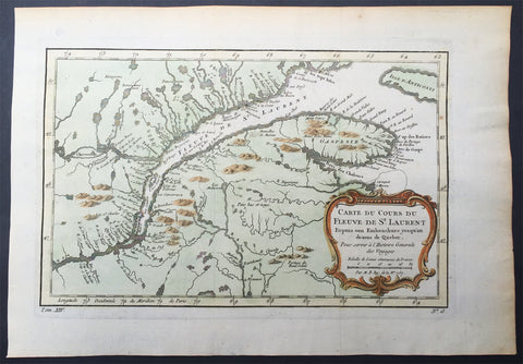
1757 Nicolas Bellin Large Antique Map Mouth of St Lawrence River Quebec, Canada
Antique Map
- Title : Carte Du Cours Du Fleuve De St Laurent...1757
- Size: 15in x 10in (380mm x 255mm)
- Condition: (A+) Fine Condition
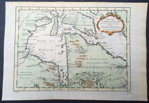
1757 Nicolas Bellin Large Antique Map of Hudsons Bay & Provinces, Canada
- Title : Carte De La Baye De Hudson...1757
- Size: 15in x 10in (380mm x 255mm)
- Condition: (A+) Fine Condition
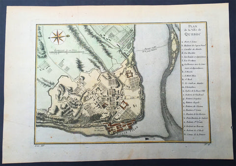
1757 Nicolas Bellin Large Antique Map of the City of Quebec, Canada
- Title : Plan de la Ville Quebec
- Size: 15in x 10in (380mm x 255mm)
- Condition: (A+) Fine Condition
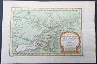
1757 Nicolas Bellin Large Antique Map St Lawrence River to Lake Ontario, Canada
- Title : Suite Du Cours De St Laurent...1757
- Size: 15in x 10in (380mm x 255mm)
- Condition: (A+) Fine Condition
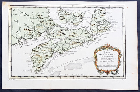
1757 Nicolas Bellin Original Antique Map of Arcadia in Nova Scotia, Canada
- Title : Carte De L' Accadie...Par M B. 1757
- Ref #: 61093
- Size: 15in x 10in (380mm x 255mm)ea
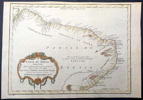
1757 Nicolas Bellin Original Antique Map of Brazil, South America
- Title : Carte Du Bresil.....
- Ref #: 61101
- Size: 15in x 10in (380mm x 255mm)
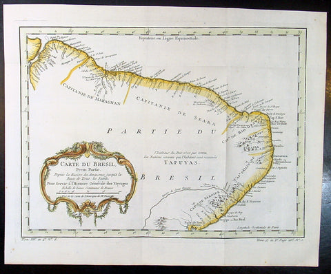
1757 Nicolas Bellin Original Antique Map of Brazil, South America
- Title : Carte Du Bresil.....
- Ref #: 60941
- Size: 15in x 10in (380mm x 255mm)
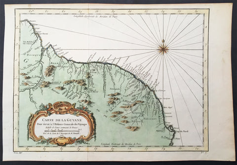
1757 Nicolas Bellin Original Antique Map of Guyana, South America
- Title : Carte De La Guyane...Par M B. 1757
- Ref #: 61099
- Size: 15in x 10in (380mm x 255mm)
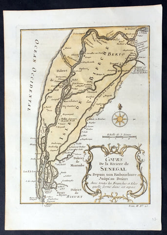
1757 Nicolas Bellin Original Antique Map Saloum River Delta, Senegal West Africa
- Title : Cours de la Riviere de Senegal...
- Ref #: 92505
- Size: 10in x 7in (255mm x 180mm)
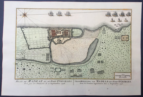
1757 Prevost & Schley Antique Map Ft St George Madras, Chennai, Tamil Nadu India
- Title : Plan de Madraz et du Fort St Georges. Pris par les Francois le 23 Septembre 1746
- Ref #: 61073
- Size: 15in x 10in (380mm x 255mm)
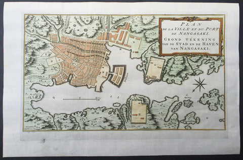
1757 Prevost & Schley Antique Map of The Port of Nagasaki, Japan - VOC, Deshima
- Title : Plan De La Ville et du Port du Nangasaki - Grond Tekening van de Stad en de Haven van Nangasaki
- Ref #: 61059
- Size: 15 1/2in x 10in (395mm x 255mm)
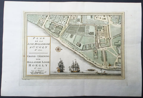
1757 Prevost & Schley Antique Map VOC Fort Hoogly & Chuchura, West Bengal, India
- Title : Plan de la Loge Hollandoise d Ougly A. 1721
- Ref #: 61069
- Size: 15in x 10in (380mm x 255mm)
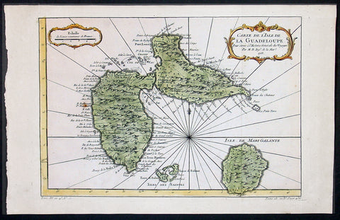
1758 Bellin Antique Map of Guadeloupe Islands, Caribbean, West Indies
- Title : Carte De L'Isle De La Guadeloupe...1758
- Ref #: 60955
- Size: 15in x 10in (380mm x 255mm)
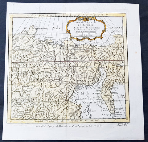
1758 Bellin Old, Antique Map of Eastern Siberia and the Kamchatka Peninsula Russia
- Title : Suite de la Carte de La Siberie et le Pays Kamtschatka
- Ref #: 60929
- Size: 11 3/4in x 11 3/4in (300mm x 300mm)
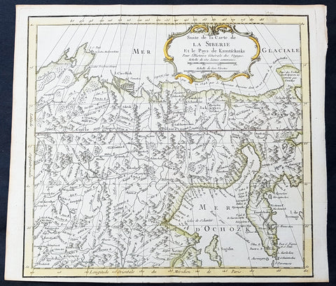
1758 Bellin Old, Antique Map of Eastern Siberia and the Kamchatka Peninsula Russia
- Title : Suite de la Carte de La Siberie et le Pays Kamtschatka
- Ref #: 15934
- Size: 12in x 12in (305mm x 305mm)
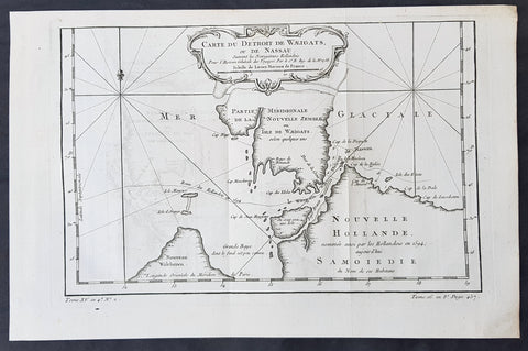
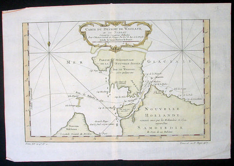
1758 Bellin Original Antique Map of Novaya Zemlya Nenets, Russia Willem Barentsz
- Title : Carte Du Détroit De Weigats ou De Nassau, suivant les Navigateurs Hollandois Pour l Histoire Générale des Voyages.1758
- Size: 14 1/2in x 9 1/2in (370mm x 240mm)
- Ref #: 60965
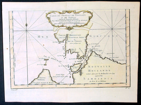
1758 Bellin Original Antique Map of Novaya Zemlya Nenets, Russia Willem Barentsz
- Title : Carte Du Détroit De Weigats ou De Nassau, suivant les Navigateurs Hollandois Pour l Histoire Générale des Voyages.1758
- Size: 15in x 10in (380mm x 255mm)
- Ref #: 23311
1758 Bellin Original Antique Map of Novaya Zemlya Nenets, Russia Willem Barentsz
- Title : Carte Du Détroit De Weigats ou De Nassau, suivant les Navigateurs Hollandois Pour l Histoire Générale des Voyages.1758
- Size: 15in x 10in (380mm x 255mm)
- Ref #: 25639
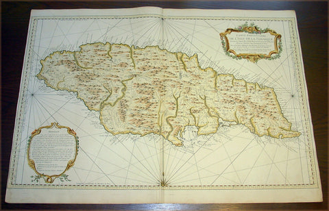
1758 Bellin Very Large Antique Map Sea Chart of the Caribbean Island of Jamaica
- Title : Carte Particuliere De L'Isle De La Jamaique ...MDCCLVIII
- Date : 1758
- Condition: (A+) Fine Condition
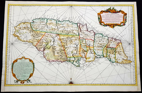
1758 J N Bellin Large Antique Map of The Caribbean Island of Jamaica
- Title : Carte Particuliere De L Isle De La Jamaique Dressee au Depost des Cartes Plans et Journaux de la Marine . . . M. DCC LVIII
- Date : 1758
- Condition: (A+) Fine Condition
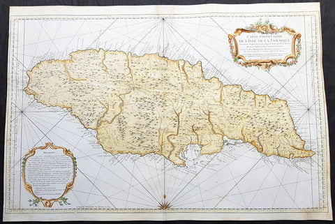
1758 J N Bellin Large Antique Map of The Caribbean Island of Jamaica
Antique Map
- Title : Carte Particuliere De L Isle De La Jamaique Dressee au Depost des Cartes Plans et Journaux de la Marine . . . M. DCC LVIII
- Date : 1758
- Condition: (A) Very Good Condition
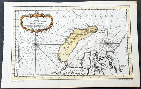
1758 Nicolas Bellin Original Antique Map of Russia The Island of Novaya Zemlya
- Title : Partie De La Mer Glaciale Contenant La Nouvelle Zemle...M. Bellin...1758
- Ref #: 60968
- Size: 15 1/2in x 10in (380mm x 260mm)
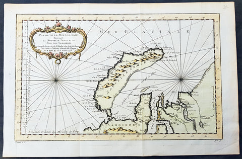
1758 Nicolas Bellin Original Antique Map of Russia The Island of Novaya Zemlya
- Title : Partie De La Mer Glaciale Contenant La Nouvelle Zemle...M. Bellin...1758
- Ref #: 25638
- Size: 15 1/2in x 10in (380mm x 260mm)
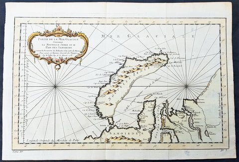
1758 Nicolas Bellin Original Antique Map of Russia The Island of Novaya Zemlya
- Title : Partie De La Mer Glaciale Contenant La Nouvelle Zemle...M. Bellin...1758
- Ref #: 25638
- Size: 15 1/2in x 10in (380mm x 260mm)
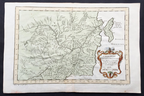
1760 Bellin Antique Map of Manchurian Empire, Mongolia, China, Sakhalin Islands
- Title: Carte De la Tartarie Orientale...P.P Jesuits
- Date: 17560
- Condition : (A+) Fine Condition

1760 Bellin Antique Map The Entrance to the Sierra Leone River, Africa
- Title: Carte De L Entrée De La Riviere De Sierra Leona...
- Date: 1760
- Condition : (A+) Fine Condition
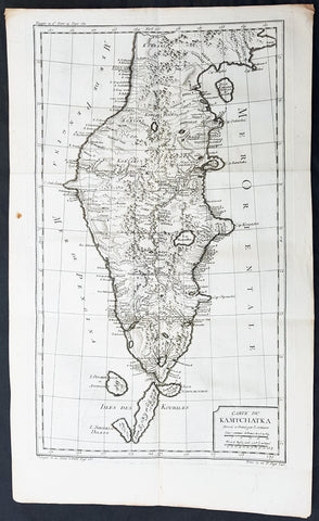
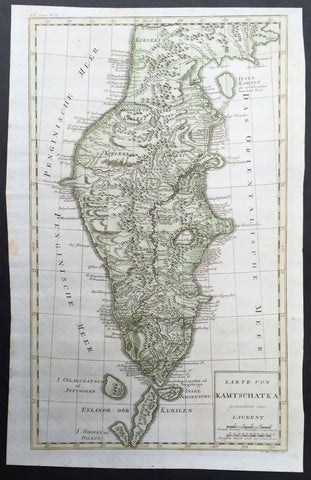
1760 Bellin Large Original Antique Map of Kamchatka Peninsula, in Eastern Russia
- Title : Carte Du Kamtschatka Dressee et Gravee par Laurent.
- Ref #: 60969
- Size: 23in x 14 1/2in (585mm x 370mm)
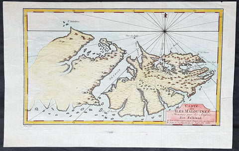
1760 Nicolas Bellin Antique Map of The Falkland Islands, South America
- Title : Carte des Îles Malouines
- Ref #: 93383
- Size: 15in x 9 1/2in (380mm x 235mm)
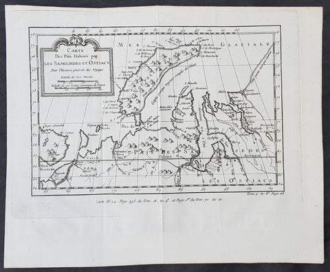
1760 Nicolas Bellin Original Antique Map of Novaya Zemlya & Barent Arctic Russia
- Title : Carte des Pais Habites par Les Samojedes et Ostiacs...
- Size: 12in x 10in (305mm x 255mm)
- Ref #: 60930
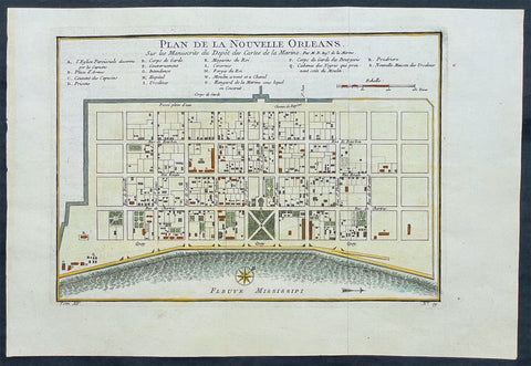
1764 Bellin Antique Map - Plan of The City of New Orleans, Louisiana, North America
- Title : Plan de la Nouvelle Orleans
- Ref #: 17041
- Size: 14 1/2in x 10in (360mm x 255mm)
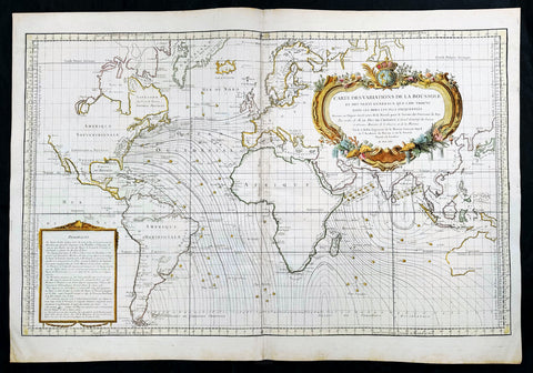
1765 Bellin Large Antique World Map of Global Winds & Magnetic Variations
Antique Map
- Title : Carte des Variations de la Boussole et des Vents Generaux que l'on Trouve dans les Mers les Plus Frequentees
- Date : 1765
- Size: 36in x 25in (910mm x 635mm)
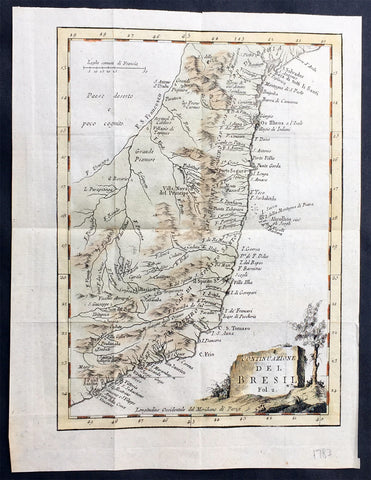
1765 Nicolas Bellin Original Antique Map of Brazil, San Salvador to Sao Paulo
- Title : Suite du Bresil
- Ref #: 61077
- Size: 10in x 7 1/2in (255mm x 190mm)
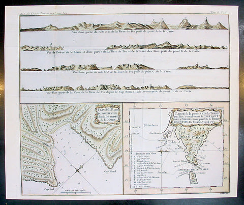
1770 Bellin Antique Map & Views Tierra del Fuego Magellan Straits, South America
- Title : Plan de Baye Dubon Succes dans le Detriot de le Maire: Carte de la Partie de la Terre De Feu comprenant le Detroit de le Marie et une Part de la Terre des Stats Par le Lieut J Cook 1769
- Ref #: 25587
- Size: 15 1/2in x 13in (395m x 330mm)

1770 JN Bellin Very Large Original Antique World Map on Mercators Projection
- Title : Essay d' une Carte Reduite Contenant les parties connuees Du Globe Terrestre
- Date : 1770
- Size: 32in x 23in (815mm x 585mm)
1771 Bellin Large Original Antique Map of The Kamchatka Peninsula Eastern Russia
- Title : Karte Von Kamtschatka gezeichnet von Laurent...P. Mol Sculs..... 1771
- Ref #: 32212
- Size: 21in x 13 1/2in (530mm x 340mm)
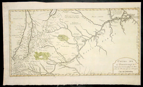
1773 Bellin Antique Map The Course of the Orinoco River South America - Rare
- Title : Cours De L Orenoque...1773
- Ref #: 92803
- Size: 18 1/2in x 11 1/2in (460mm x 295mm)
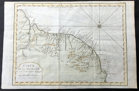
1773 Nicolas Bellin Original Antique Map of Guyana, South America
- Title: Carte De La Guiane.....
- Date: 1773
- Condition : (A+) Fine Condition
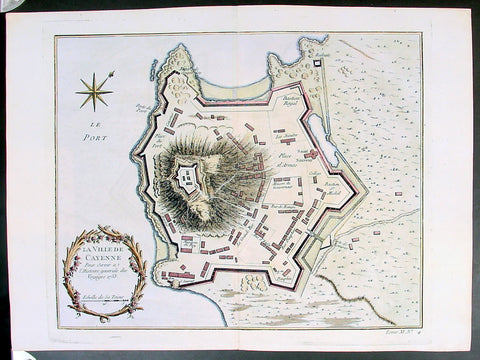
Copy of 1753 Bellin Antique Map Plan of the City of Cayenne French Guyana, South America
- Title: La Ville De Cayenne...1753
- Date: 1753
- Condition : (A+) Fine Condition
Copy of 1755 Prevost & Schley Antique Map of Xi an & Guanzhong in Shaanxi Province China
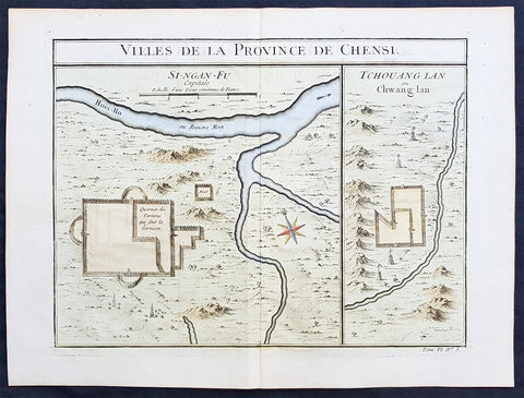
- Title: Villes De La Province De Chensi (Si-ngan-fu Capitale / Tchouang Lan ou Chwang lan)
- Date: 1755
- Condition : (A+) Fine Condition