Products
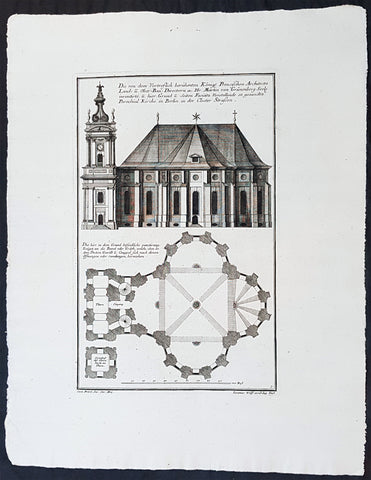
1740 Wolff & Corvinus Antique Architectural Print Parochialkirche, Mitte, Berlin
- Title : Die Von dem Vortreslich beruhmten Konigl. Preusichen Architect Land u. Ober Bau Directorn etc. Hr. Martin von Grunenberg Seel. inventirte, u. hier Grund u. Seiten Faciata Vorstellende so genandte Parochial Kirche in Berlin in der Closter Strassen
- Ref #: 93451
- Size: 19in x 12 1/2in (490mm x 335mm)
- Date : 1740
- Condition: (A+) Fine Condition
Description:
This large rare, original copper-plate engraved antique architectural print of the Parochialkirche (literally the Reformed parochial church) in the Mitte suburb of Berlin - plate No. 5 of 16 - by Johann August Corvinus 1683 - 1738, after Andreas Mayers 1716 - 1782, was published in Eigentliche Abbildung des Prächtigen Königl. Lust Schlosses Charlottenburg, eine Meile von Berlin, sambt dem darhinden im Walde gelegenen schönen Lust Garten
(Set of 16 numbered plates, the first with the title, with plans and views of the buildings and gardens at Charlottenburg, the palace of the King of Prussia on the outskirts of Berlin.) by Jeremias Wolff Erben in 1740.
General Definitions:
Paper thickness and quality: - Heavy and stable
Paper color : - off white
Age of map color: -
Colors used: -
General color appearance: -
Paper size: - 19in x 12 1/2in (490mm x 335mm)
Plate size: - 14 1/2in x 10 1/2in (370mm x 260mm)
Margins: - Min 1in (25mm)
Imperfections:
Margins: - None
Plate area: - None
Verso: - None
Background:
Berlin straddles the banks of the River Spree, which flows into the River Havel (a tributary of the River Elbe) in the western borough of Spandau. Among the citys main topographical features are the many lakes in the western and southeastern boroughs formed by the Spree, Havel, and Dahme rivers (the largest of which is Lake Müggelsee). Due to its location in the European Plain, Berlin is influenced by a temperate seasonal climate. About one-third of the citys area is composed of forests, parks, gardens, rivers, canals and lakes. The city lies in the Central German dialect area, the Berlin dialect being a variant of the Lusatian-New Marchian dialects.
First documented in the 13th century and situated at the crossing of two important historic trade routes, Berlin became the capital of the Margraviate of Brandenburg (1417–1701), the Kingdom of Prussia (1701–1918), the German Empire (1871–1918), the Weimar Republic (1919–1933), and the Third Reich (1933–1945). Berlin in the 1920s was the third-largest municipality in the world. After World War II and its subsequent occupation by the victorious countries, the city was divided; West Berlin became a de facto West German exclave, surrounded by the Berlin Wall (1961–1989) and East German territory. East Berlin was declared capital of East Germany, while Bonn became the West German capital. Following German reunification in 1990, Berlin once again became the capital of all of Germany.
The Thirty Years War between 1618 and 1648 devastated Berlin. One third of its houses were damaged or destroyed, and the city lost half of its population. Frederick William, known as the Great Elector, who had succeeded his father George William as ruler in 1640, initiated a policy of promoting immigration and religious tolerance. With the Edict of Potsdam in 1685, Frederick William offered asylum to the French Huguenots.
By 1700, approximately 30 percent of Berlins residents were French, because of the Huguenot immigration. Many other immigrants came from Bohemia, Poland, and Salzburg.
Since 1618, the Margraviate of Brandenburg had been in personal union with the Duchy of Prussia. In 1701, the dual state formed the Kingdom of Prussia, as Frederick III, Elector of Brandenburg, crowned himself as king Frederick I in Prussia. Berlin became the capital of the new Kingdom, replacing Königsberg. This was a successful attempt to centralise the capital in the very far-flung state, and it was the first time the city began to grow. In 1709, Berlin merged with the four cities of Cölln, Friedrichswerder, Friedrichstadt and Dorotheenstadt under the name Berlin, Haupt- und Residenzstadt Berlin.
In 1740, Frederick II, known as Frederick the Great (1740–1786), came to power. Under the rule of Frederick II, Berlin became a center of the Enlightenment, but also, was briefly occupied during the Seven Years War by the Russian army. Following Frances victory in the War of the Fourth Coalition, Napoleon Bonaparte marched into Berlin in 1806, but granted self-government to the city. In 1815, the city became part of the new Province of Brandenburg.
The Industrial Revolution transformed Berlin during the 19th century; the citys economy and population expanded dramatically, and it became the main railway hub and economic centre of Germany. Additional suburbs soon developed and increased the area and population of Berlin. In 1861, neighbouring suburbs including Wedding, Moabit and several others were incorporated into Berlin. In 1871, Berlin became capital of the newly founded German Empire. In 1881, it became a city district separate from Brandenburg.
Wolff, Jeremais 1663 - 1724
Wolff was an German engraver and publisher. Born in Augsburg, he originally trained as a clock and automat maker, later changing course and opening a small copperplate engraving shop. His success was impressive and became one of the largest European art, print & map publishers in the first half of the 18th century. Wolff employed some of the best engravers of the time and although not an engraver himself, only Wolffs name was recorded on the engravings. Many of his engravers went uncredited for their work. In 1710 Wolff was one of the founder member of the Empire State Academy of Arts in Augsburg.
After his death in 1724, Wolffs publishing business was inherited by his sons and son-in-law, Johann Balthasar Probst (1673–1750) a notable engraver at the time. The firm continued on in Augsburg under the name Jeremias Wolff Erben.
Together with the Nuremberg copperplate engraver Paul Decker , Wolff published a series of engravings showing the war successes of Prince Eugene of Savoy in Italy , southern Germany and the Spanish Netherlands, during the War of the Spanish Succession . The prints are exhibited in the Museum of Military History, in Vienna .
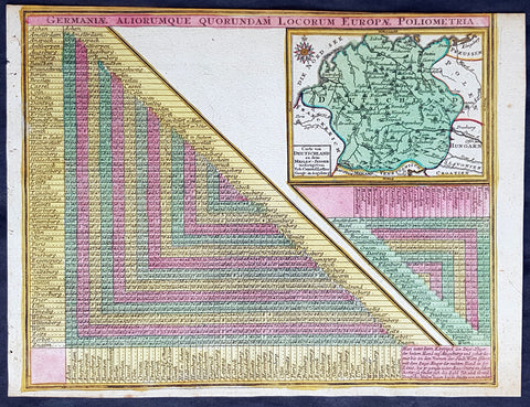
1744 Georg Mattaus Seutter Antique Map of Germany w/ European City Mileage Chart
- Title : Germaniae Aliorumque Quorundam Locorum Europae Poliometria....Cart von Deutsschland...Tob. Conrad Lotter Geogr.
- Ref #: 93404
- Size: 11in x 8 1/2in (280mm x 215mm)
- Date : 1744
- Condition: (A+) Fine Condition
Description:
This beautifully hand coloured original copper-plate engraved antique map of Germany, with a mileage index chart with all the major cities of Europe, was engraved by Tobias Lotter and was published in the 1744 edition of GM Seutters Atlas Minor Prae cipua Orbis Terrarum Imperia Regna et Provincias...., Augsburg, Germany.
General Definitions:
Paper thickness and quality: - Heavy and stable
Paper color : - off white
Age of map color: - Original
Colors used: - Yellow, green, blue, pink
General color appearance: - Authentic
Paper size: - 11in x 8 1/2in (280mm x 215mm)
Plate size: - 10 1/2in x 8in (265mm x 205mm)
Margins: - Min 1/4in (5mm)
Imperfections:
Margins: - Light age toning
Plate area: - Light age toning
Verso: - None
Background:
Atlas Minor was a series of beautiful maps of all parts of the world. Georg Matthäus Seutter was one of the most and important of the German cartographers of the 18th century, being appointed as the Geographer to the Imperial Court. His son, Albrecht Carl, joined Matthäus and eventually inherited the business. The maps from Atlas Minor were drawn by the two Seutters and engraved by Tobias Conrad Lotte. These maps are highly detailed and engraved with a bold hand with equally strong original hand color in the body of the map as was the 18th century German style. The cartouches were left uncolored in order to emphasize the elaborately detailed illustrations for which German maps are especially prized. These are some of the most decorative and interesting maps of the eighteenth century.

1744 Georg Mattaus Seutter Antique Map of Germany, Central & NW Europe
- Title : Imperium Romano Germanicum........a Matth. Seutteri...T C Lotter, Geogr.
- Ref #: 93398
- Size: 11in x 8 1/2in (280mm x 215mm)
- Date : 1744
- Condition: (A+) Fine Condition
Description:
This beautifully hand coloured original copper-plate engraved antique map of Germany and NW Europe was engraved by Tobias Lotter and was published in the 1744 edition of GM Seutters Atlas Minor Prae cipua Orbis Terrarum Imperia Regna et Provincias...., Augsburg, Germany.
General Definitions:
Paper thickness and quality: - Heavy and stable
Paper color : - off white
Age of map color: - Original
Colors used: - Yellow, green, blue, pink
General color appearance: - Authentic
Paper size: - 11in x 8 1/2in (280mm x 215mm)
Plate size: - 10 1/2in x 8in (265mm x 205mm)
Margins: - Min 1/4in (5mm)
Imperfections:
Margins: - Light age toning
Plate area: - Light age toning
Verso: - None
Background:
Atlas Minor was a series of beautiful maps of all parts of the world. Georg Matthäus Seutter was one of the most and important of the German cartographers of the 18th century, being appointed as the Geographer to the Imperial Court. His son, Albrecht Carl, joined Matthäus and eventually inherited the business. The maps from Atlas Minor were drawn by the two Seutters and engraved by Tobias Conrad Lotte. These maps are highly detailed and engraved with a bold hand with equally strong original hand color in the body of the map as was the 18th century German style. The cartouches were left uncolored in order to emphasize the elaborately detailed illustrations for which German maps are especially prized. These are some of the most decorative and interesting maps of the eighteenth century.
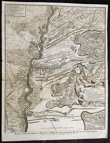
1745 Nicolas Tindal Antique Map The Battle of Blenheim, Germany in 1704
- Title : Plan of the Glorious Battle of Hochstet gained by the Allies on August 13.th 1704.
- Size: 21in x 17in (530mm x 430mm)
- Ref #: 15692-1
- Date : 1745
- Condition: (A+) Fine Condition
Description:
This original copper-plate engraved antique map, plan of the The Battle of Blenheim or Hochstadt, fought in Bavaria, Germany in August 1704 - during the Spanish War of Succession (1701-13) - was engraved by John Basire and was published in the 1745 edition of Nicholas Tindals Continuation of Mr. Rapins History of England.
General Definitions:
Paper thickness and quality: - Heavy and stable
Paper color : - off white
Age of map color: -
Colors used: -
General color appearance: -
Paper size: - 21in x 17in (530mm x 430mm)
Plate size: - 21in x 17in (530mm x 430mm)
Margins: - Min 1/2in (12mm)
Imperfections:
Margins: - None
Plate area: - Folds as issued
Verso: - None
Background:
The Battle of Blenheim (German: Zweite Schlacht bei Höchstädt; French Bataille de Höchstädt), fought on 13 August 1704, was a major battle of the War of the Spanish Succession. The overwhelming Allied victory ensured the safety of Vienna from the Franco-Bavarian army, thus preventing the collapse of the Grand Alliance.
Louis XIV of France sought to knock the Holy Roman Emperor, Leopold out of the war by seizing Vienna, the Habsburg capital, and gain a favourable peace settlement. The dangers to Vienna were considerable: the Elector of Bavaria and Marshal Marsins forces in Bavaria threatened from the west, and Marshal Vendômes large army in northern Italy posed a serious danger with a potential offensive through the Brenner Pass. Vienna was also under pressure from Rákóczis Hungarian revolt from its eastern approaches. Realising the danger, the Duke of Marlborough resolved to alleviate the peril to Vienna by marching his forces south from Bedburg to help maintain Emperor Leopold within the Grand Alliance.
A combination of deception and skilled administration – designed to conceal his true destination from friend and foe alike – enabled Marlborough to march 400 kilometres (250 miles) unhindered from the Low Countries to the River Danube in five weeks. After securing Donauwörth on the Danube, Marlborough sought to engage the Electors and Marsins army before Marshal Tallard could bring reinforcements through the Black Forest. However, with the Franco-Bavarian commanders reluctant to fight until their numbers were deemed sufficient, the Duke enacted a policy of plundering in Bavaria designed to force the issue. The tactic proved unsuccessful, but when Tallard arrived to bolster the Electors army, and Prince Eugene arrived with reinforcements for the Allies, the two armies finally met on the banks of the Danube in and around the small village of Blindheim, from which the English Blenheim is derived.
Blenheim was one of the battles that altered the course of the war, which until then was leaning for Louis coalition, and ended French plans of knocking the Emperor out of the war. France suffered as many as 38,000 casualties including the commander-in-chief, Marshal Tallard, who was taken captive to England. Before the 1704 campaign ended, the Allies had taken Landau, and the towns of Trier and Trarbach on the Moselle in preparation for the following years campaign into France itself. The offensive never materialised as the Grand Alliances army had to depart the Moselle to defend Liège from a French counteroffensive. The war would rage on for another decade.
Tindal, Nicolas 1687 – 1774
Nicolas Tindal was the translator and continuer of the History of England published by Paul de Rapin (1661-1725) in 1724. De Rapins publication chronicles the History of Britain from the invasion of the Romans to the death of Charles I. Very few comprehensive histories of England existed at the time and Tindal added his three-volume Continuation, of the Kingdom, from the reigns of James II to George II.
Tindal\\\'s translation of de Rapins History, was first published in 1727. Tindal enlarged the volumes in their second edition (1732) to contain notes, genealogical tables and maps of his own composition. In 1745 Tindal published Tindal’s Continuation of Mr. Rapin’s History of England. Included with this edition was an atlas containing 45 maps, battle and town plans from the Spanish War of Succession (1701-13) that were engraved by Richard William Seale and John Basire.
These maps represent battles that took place during the War of Spanish Succession, concluded by the Treaties of Utrecht. The war resulted from a dispute over who should inherit Spain and its possessions after its Habsburg rulers in 1700. The last Habsburg king of Spain, Charles II (d. 1700) had left the throne to his closest relative in female line: Philippe de France, duke of Anjou, grandson of Louis XIV (Felipe V of Spain). The closest relatives in male line, the Habsburgs of Austria, disputed this claim, and many European nations did not want to see French princes reigning over both kingdoms. The Utrecht treaties recognized Felipe V of Spain, but transferred the Spanish possessions in the Netherlands and Italy to Austria and to Savoy. To reach the goal of separating the crowns of France and Spain, the treaties required Felipe V to relinquish all claims to the French throne, and the remaining French princes to relinquish all claims to the Spanish throne.
The War of the Spanish Succession, was also known as Marlboroughs Wars, that was fought in Europe and the Mediterranean, and were the last and the bloodiest of the Wars between England and France under Louis XIV, and the first in which Britain played a major military role in European military affairs.
Paul de Rapin 1661-1725 was born in Castes and educated at the Protestant academy of Saumur. In 1685 after the death of his father he moved to England but after being unable to find employment moved to Holland and enlisted in French volunteers at Utrecht commanded by his cousin Daniel de Rapin. He accompanied the prince of Orange to England in 1688 and participated in the Irish campaigns of the siege of Carrickfergus, Battle of the Boyne and Limerick. Rapin resigned to become tutor to the Earl of Portlands son. He settled in Holland where he began work on The History of England. It was published in Holland in 1724 in 8 volumes. The work was an attempt to be exhaustive in the spirit of the eighteenth century philosophies by treating the subject from prehistoric times up to the date of publication.
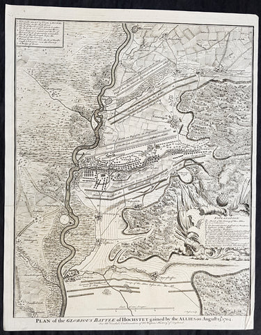
1745 Nicolas Tindal Antique Map The Battle of Blenheim, Germany in 1704
- Title : Plan of the Glorious Battle of Hochstet gained by the Allies on August 13.th 1704.
- Size: 21in x 17in (530mm x 430mm)
- Ref #: 22178
- Date : 1745
- Condition: (A+) Fine Condition
Description:
This original copper-plate engraved antique map, plan of the The Battle of Blenheim or Hochstadt, fought in Bavaria, Germany in August 1704 - during the Spanish War of Succession (1701-13) - was engraved by John Basire and was published in the 1745 edition of Nicholas Tindals Continuation of Mr. Rapins History of England.
General Definitions:
Paper thickness and quality: - Heavy and stable
Paper color : - off white
Age of map color: -
Colors used: -
General color appearance: -
Paper size: - 21in x 17in (530mm x 430mm)
Plate size: - 21in x 17in (530mm x 430mm)
Margins: - Min 1/2in (12mm)
Imperfections:
Margins: - None
Plate area: - Folds as issued
Verso: - None
Background:
The Battle of Blenheim (German: Zweite Schlacht bei Höchstädt; French Bataille de Höchstädt), fought on 13 August 1704, was a major battle of the War of the Spanish Succession. The overwhelming Allied victory ensured the safety of Vienna from the Franco-Bavarian army, thus preventing the collapse of the Grand Alliance.
Louis XIV of France sought to knock the Holy Roman Emperor, Leopold out of the war by seizing Vienna, the Habsburg capital, and gain a favourable peace settlement. The dangers to Vienna were considerable: the Elector of Bavaria and Marshal Marsins forces in Bavaria threatened from the west, and Marshal Vendômes large army in northern Italy posed a serious danger with a potential offensive through the Brenner Pass. Vienna was also under pressure from Rákóczis Hungarian revolt from its eastern approaches. Realising the danger, the Duke of Marlborough resolved to alleviate the peril to Vienna by marching his forces south from Bedburg to help maintain Emperor Leopold within the Grand Alliance.
A combination of deception and skilled administration – designed to conceal his true destination from friend and foe alike – enabled Marlborough to march 400 kilometres (250 miles) unhindered from the Low Countries to the River Danube in five weeks. After securing Donauwörth on the Danube, Marlborough sought to engage the Electors and Marsins army before Marshal Tallard could bring reinforcements through the Black Forest. However, with the Franco-Bavarian commanders reluctant to fight until their numbers were deemed sufficient, the Duke enacted a policy of plundering in Bavaria designed to force the issue. The tactic proved unsuccessful, but when Tallard arrived to bolster the Electors army, and Prince Eugene arrived with reinforcements for the Allies, the two armies finally met on the banks of the Danube in and around the small village of Blindheim, from which the English Blenheim is derived.
Blenheim was one of the battles that altered the course of the war, which until then was leaning for Louis coalition, and ended French plans of knocking the Emperor out of the war. France suffered as many as 38,000 casualties including the commander-in-chief, Marshal Tallard, who was taken captive to England. Before the 1704 campaign ended, the Allies had taken Landau, and the towns of Trier and Trarbach on the Moselle in preparation for the following years campaign into France itself. The offensive never materialised as the Grand Alliances army had to depart the Moselle to defend Liège from a French counteroffensive. The war would rage on for another decade.
Tindal, Nicolas 1687 – 1774
Nicolas Tindal was the translator and continuer of the History of England published by Paul de Rapin (1661-1725) in 1724. De Rapins publication chronicles the History of Britain from the invasion of the Romans to the death of Charles I. Very few comprehensive histories of England existed at the time and Tindal added his three-volume Continuation, of the Kingdom, from the reigns of James II to George II.
Tindal\\\'s translation of de Rapins History, was first published in 1727. Tindal enlarged the volumes in their second edition (1732) to contain notes, genealogical tables and maps of his own composition. In 1745 Tindal published Tindal’s Continuation of Mr. Rapin’s History of England. Included with this edition was an atlas containing 45 maps, battle and town plans from the Spanish War of Succession (1701-13) that were engraved by Richard William Seale and John Basire.
These maps represent battles that took place during the War of Spanish Succession, concluded by the Treaties of Utrecht. The war resulted from a dispute over who should inherit Spain and its possessions after its Habsburg rulers in 1700. The last Habsburg king of Spain, Charles II (d. 1700) had left the throne to his closest relative in female line: Philippe de France, duke of Anjou, grandson of Louis XIV (Felipe V of Spain). The closest relatives in male line, the Habsburgs of Austria, disputed this claim, and many European nations did not want to see French princes reigning over both kingdoms. The Utrecht treaties recognized Felipe V of Spain, but transferred the Spanish possessions in the Netherlands and Italy to Austria and to Savoy. To reach the goal of separating the crowns of France and Spain, the treaties required Felipe V to relinquish all claims to the French throne, and the remaining French princes to relinquish all claims to the Spanish throne.
The War of the Spanish Succession, was also known as Marlboroughs Wars, that was fought in Europe and the Mediterranean, and were the last and the bloodiest of the Wars between England and France under Louis XIV, and the first in which Britain played a major military role in European military affairs.
Paul de Rapin 1661-1725 was born in Castes and educated at the Protestant academy of Saumur. In 1685 after the death of his father he moved to England but after being unable to find employment moved to Holland and enlisted in French volunteers at Utrecht commanded by his cousin Daniel de Rapin. He accompanied the prince of Orange to England in 1688 and participated in the Irish campaigns of the siege of Carrickfergus, Battle of the Boyne and Limerick. Rapin resigned to become tutor to the Earl of Portlands son. He settled in Holland where he began work on The History of England. It was published in Holland in 1724 in 8 volumes. The work was an attempt to be exhaustive in the spirit of the eighteenth century philosophies by treating the subject from prehistoric times up to the date of publication.
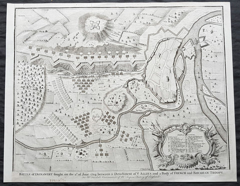
1745 Nicolas Tindal Large Antique Map The Battle of Schellenberg, Germany 1704
- Title : Battle of Donawert fought on the 2nd of June 1704 between a detachment of ye Allies and a body of French and Bavarian Troops
- Size: 20in x 16in (510mm x 410mm)
- Condition: (A+) Fine Condition
- Date : 1745
- Ref #: 22160
Description:
This large original antique copper-plate engraved military map of the Battle of Schellenberg, also known as the Battle of Donauwörth in the Donau-Ries district of Swabia, in Bavaria, Germany - during the Spanish War of Succession - was engraved by John Basire and published in the 1745 edition of Nicholas Tindals Continuation of Mr. Rapins History of England.
General Definitions:
Paper thickness and quality: - Heavy and stable
Paper color : - off white
Age of map color: -
Colors used: -
General color appearance: -
Paper size: - 20in x 16in (510mm x 410mm)
Plate size: - 20in x 16in (510mm x 410mm)
Margins: - Min 1/2in (10mm)
Imperfections:
Margins: - None
Plate area: - Folds as issued
Verso: - None
The Battle of Schellenberg, also known as the Battle of Donauwörth, was fought on 2 July 1704 during the War of the Spanish Succession. The engagement was part of the Duke of Marlboroughs campaign to save the Habsburg capital of Vienna from a threatened advance by King Louis XIVs Franco-Bavarian forces ranged in southern Germany. Marlborough had commenced his 400 km march from Bedburg, near Cologne, on 19 May; within five weeks he had linked his forces with those of the Margrave of Baden, before continuing on to the river Danube. Once in southern Germany, the Allies task was to induce Max Emanuel, the Elector of Bavaria, to abandon his allegiance to Louis XIV and rejoin the Grand Alliance; but to force the issue, the Allies first needed to secure a fortified bridgehead and magazine on the Danube, through which their supplies could cross to the south of the river into the heart of the Electors lands. For this purpose, Marlborough selected the town of Donauwörth.
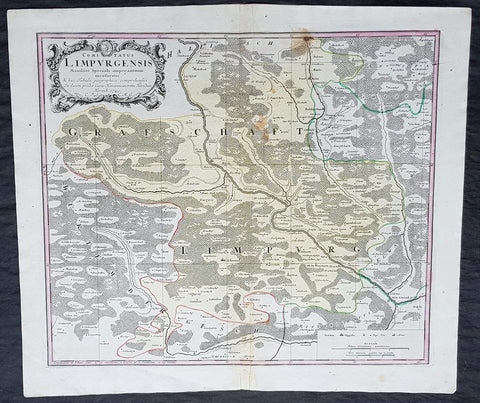
1749 Homann Antique Map Limpurg County, Schwabisch-Hall Baden-Wurtemberg Germany
- Title : Comitatus Limpurgensis Mandato Speciali imperantium mensuratus & hac Tabula geographica comprehensus / In lucem prodit Curis Homannianorum Heredum / Norimb 1749
- Date : 1749
- Condition: (A+) Fine Condition
- Ref: 20428
- Size: 23 1/2in x 20in (595mm x 510mm)
Description:
This large original copper-plate engraved antique map of Limpurg County in the district of Schwäbisch-Hallin in the state of Baden-Wurtemberg, SW Germany by the Homann Heirs was engraved in 1749 - dated in cartouche - and published in the Homanns 1750 German Atlas.
Limpurg is situated in the present-day district of Schwäbisch-Hall or Ostalbkreis between Schwäbisch-Hall, Schwäbisch Gmünd, Aalen and Ellwangen.
The map centers on the river Kocher, with towns marked such as Schwäbisch-Hall (Comburg), Gaildorf, Abstgemünd and Bühlertann.
General Definitions:
Paper thickness and quality: - Heavy and stable
Paper color : - off white
Age of map color: - Original
Colors used: - Yellow, Green, pink
General color appearance: - Authentic
Paper size: - 23 1/2in x 20in (595mm x 510mm)
Plate size: - 21in x 18in (535mm x 460mm)
Margins: - Min 1/4in (5mm)
Imperfections:
Margins: - None
Plate area: - Light soiling
Verso: - None
Background:
Baden-Württemberg is formed from the historical territories of Baden, Prussian Hohenzollern, and Württemberg, and also parts of Swabia.
In 100 AD, the Roman Empire invaded and occupied Württemberg, constructing a limes (fortified boundary zone) along its northern borders. Over the course of the third century AD, the Alemanni forced the Romans to retreat west beyond the Rhine and Danube rivers. In 496 AD the Alemanni were defeated by a Frankish invasion led by Clovis I.
The Holy Roman Empire was later established. The majority of people in this region continued to be Roman Catholics, even after the Protestant Reformation influenced populations in northern Germany. In the late-nineteenth and early-twentieth centuries, numerous people emigrated from this mostly rural area to the United States for economic reasons.
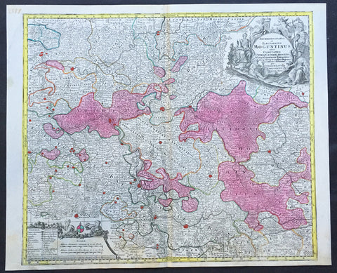
1756 Lotter Large Antique Map of Rhine Koblenz, Germany
- Title : Archiepiscopatus et Electoratus Moguntinus...
- Ref #: 50169
- Size: 25in x 20in (635mm x 510mm)
- Date : 1756
- Condition: (A+) Fine Condition
Description:
This large beautiful hand coloured original antique map of the Rhine River region of central western Germany was engraved by Tobias Conrad Lotter in 1756.
The map centres on the city of Frankfurt stretches along the Rhine River from Koblenz in the North to Speir in the South. Wertheim in the east to Kern in the west (Ref: Tooley, M&B)
General Description:
Paper thickness and quality: - Heavy and stable
Paper color: - off white
Age of map color: - Original
Colors used: - Pink, green, yellow, blue
General color appearance: - Authentic
Paper size: - 25in x 20in (635mm x 510mm)
Plate size: - 22 ½in x 19 ½in (570mm x 495mm)
Margins: - Min 1/2in (12mm)
Imperfections:
Margins: - None
Plate area: - None
Verso: - None
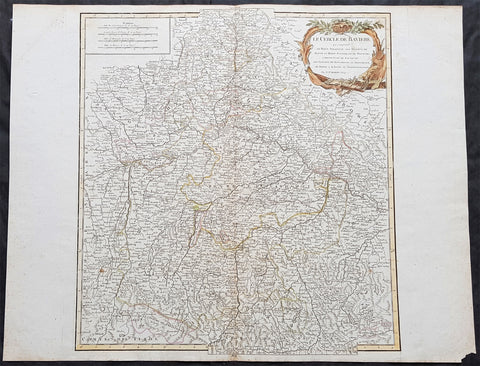
1757 Robert De Vaugondy Large Antique Map of Bavaria & River Danube, Germany
- Title : Le Cercle De Baviere.......Par Le Sr. Robert
- Size: 26in x 20in (660mm x 510mm)
- Condition: (A+) Fine Condition
- Date : 1757
- Ref #: 41577
Description:
This large magnificent hand coloured original copper-plate engraved antique map of Bavaria, Germany - centering on the River Danube - by Robert De Vaugondy was published in the 1757 edition of De Vaugondys famous The Atlas Universel
General Definitions:
Paper thickness and quality: - Heavy and stable
Paper color : - off white
Age of map color: - Original & later
Colors used: - Blue, pink, red, green, yellow
General color appearance: - Authentic
Paper size: - 26in x 20in (660mm x 510mm)
Plate size: - 20in x 19 1/2in (510mm x 495mm)
Margins: - Min 1/2in (10mm)
Imperfections:
Margins: - None
Plate area: - None
Verso: - None
Background:
Bavaria officially the Free State of Bavaria is a landlocked federal state of Germany, occupying its southeastern corner. With an area of 70,550.19 square kilometres, Bavaria is the largest German state by land area. Its territory comprises roughly a fifth of the total land area of Germany. With 12.9 million inhabitants, it is Germany\'s second-most-populous state after North Rhine-Westphalia. Bavaria\'s capital and largest city, Munich, is the third-largest city in Germany.
The history of Bavaria stretches from its earliest settlement and formation as a duchy in the 6th century CE through the Holy Roman Empire to becoming an independent kingdom and a state of the Federal Republic of Germany.
The Duchy of Bavaria dates back to the year 555. In the 17th century CE, the Duke of Bavaria became a Prince-elector of the Holy Roman Empire. The Kingdom of Bavaria existed from 1806 to 1918, when Bavaria became a republic. In 1946, the Free State of Bavaria re-organised itself on democratic lines after the Second World War.
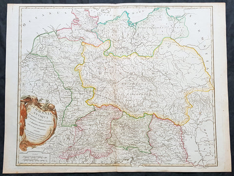
1757 Robert De Vaugondy Large Antique Map of Germania, Germany During Roman Era
- Title : Germania Antiqua in quatuor magnos populos...Autore Robert De Vaugondy
- Size: 26in x 19 1/2in (660mm x 495mm)
- Condition: (A+) Fine Condition
- Date : 1757
- Ref #: 41548
Description:
This large magnificent hand coloured original copper-plate engraved antique map of Ancient Germania, Germany, during the Roman Era by Robert De Vaugondy was published in the 1757 edition of De Vaugondys famous The Atlas Universel
General Definitions:
Paper thickness and quality: - Heavy and stable
Paper color : - off white
Age of map color: - Original & later
Colors used: - Blue, pink, red, green, yellow
General color appearance: - Authentic
Paper size: - 26in x 19 1/2in (660mm x 495mm)
Plate size: - 22 1/2in x 19 1/2in (570mm x 495mm)
Margins: - Min 1/4in (5mm)
Imperfections:
Margins: - None
Plate area: - None
Verso: - None
Background:
Germania was the Roman term for the geographical region in north-central Europe inhabited mainly by Germanic peoples.
It extended from the Danube in the south to the Baltic Sea, and from the Rhine in the west to the Vistula. The Roman portions formed two provinces of the Empire, Germania Inferior to the north (present-day southern Netherlands, Belgium, and western Germany), and Germania Superior to the south (Switzerland, southwestern Germany, and eastern France).
Germania was inhabited mostly by Germanic tribes, but also Celts, Balts, Scythians and later on Early Slavs. The population mix changed over time by assimilation, and especially by migration. The ancient Greeks were the first to mention the tribes in the area. Later, Julius Caesar wrote about warlike Germanic tribesmen and their threat to Roman Gaul, and there were military clashes between the Romans and the indigenous tribes. Tacitus wrote the most complete account of Germania that still survives.
The origin of the term Germania is uncertain, but was known by Caesar\'s time, and may be Gaulish in origin.
Germania was inhabited by different tribes, most of them Germanic but also some Celtic, proto-Slavic, Baltic and Scythian peoples. The tribal and ethnic makeup changed over the centuries as a result of assimilation and, most importantly, migrations. The Germanic people spoke several different dialects.
Classical records show little about the people who inhabited the north of Europe before the 2nd century BC. In the 5th century BC, the Greeks were aware of a group they called Celts (Keltoi). Herodotus also mentioned the Scythians but no other tribes. At around 320 BC, Pytheas of Massalia sailed around Britain and along the northern coast of Europe, and what he found on his journeys was so strange that later writers refused to believe him. He may have been the first Mediterranean to distinguish the Germanic people from the Celts. Contact between German tribes and the Roman Empire did take place and was not always hostile. Recent excavations of the Waldgirmes Forum show signs that a civilian Roman town was established there, which has been interpreted to mean that Romans and Germanic tribesmen were living in peace, at least for a while.
Caesar described the cultural differences between the Germanic tribesmen, the Romans, and the Gauls in his book Commentarii de Bello Gallico, where he recalls his defeat of the Suebi tribes at the Battle of Vosges. He describes them at length at the beginning of Book IV and the middle of Book VI. He states that the Gauls, although warlike, had a functional society and could be civilized, but that the Germanic tribesmen were far more savage and were a threat to Roman Gaul and Rome itself. Caesar said the Germanic tribes were nomadic, with no notable settlements and a primitive culture. He used this as one of his justifications for why they had to be conquered. His accounts of barbaric northern tribes could be described as an expression of the superiority of Rome, including Roman Gaul.
Caesars accounts portray the Roman fear of the Germanic tribes and the threat they posed. The perceived menace of the Germanic tribesmen proved accurate. The most complete account of Germania that has been preserved from Roman times is Tacitus Germania.
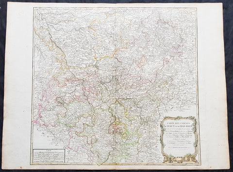
1757 Robert De Vaugondy Large Antique Map of North Rhine-Westphalia Bonn Cologne
- Title : Carte Des Cercles Du Haut et du Bas Rhin.....Par Le Sr. Robert
- Size: 26 1/2in x 19 3/4in (670mm x 505mm)
- Condition: (A+) Fine Condition
- Date : 1757
- Ref #: 41574
Description:
This large magnificent hand coloured original copper-plate engraved antique map of part of Western Germany centering on the Rhine River and the cities of Bonn & Cologne, today the North Rhine-Westphalia by Robert De Vaugondy was published in the 1757 edition of De Vaugondys famous The Atlas Universel
General Definitions:
Paper thickness and quality: - Heavy and stable
Paper color : - off white
Age of map color: - Original & later
Colors used: - Blue, pink, red, green, yellow
General color appearance: - Authentic
Paper size: - 26 1/2in x 19 3/4in (670mm x 505mm)
Plate size: - 21 1/2in x 19in (550mm x 480mm)
Margins: - Min 1/2in (10mm)
Imperfections:
Margins: - None
Plate area: - None
Verso: - None
Background:
North Rhine-Westphalia is located in western Germany covering an area of 34,084 square kilometres and a population of 17.6 million, the most populous and the most densely populated German state apart from the city-states of Berlin, Bremen, and Hamburg, and the fourth-largest by area. Düsseldorf is the state capital and Cologne is the largest city. North Rhine-Westphalia features four of Germany\'s 10 largest cities: Düsseldorf, Cologne, Dortmund, and Essen, and the Rhine-Ruhr metropolitan area, the largest in Germany and the third-largest on the European continent.
Around AD 1, numerous incursions occurred through Westphalia and perhaps even some permanent Roman or Romanized settlements. The Battle of Teutoburg Forest took place near Osnabrück (as mentioned, whether this is in Westphalia is disputed) and some of the Germanic tribes who fought at this battle came from the area of Westphalia. Charlemagne is thought to have spent considerable time in Paderborn and nearby parts. His Saxon Wars also partly took place in what is thought of as Westphalia today. Popular legends link his adversary Widukind to places near Detmold, Bielefeld, Lemgo, Osnabrück, and other places in Westphalia. Widukind was buried in Enger, which is also a subject of a legend.
Along with Eastphalia and Engern, Westphalia (Westfalahi) was originally a district of the Duchy of Saxony. In 1180, Westphalia was elevated to the rank of a duchy by Emperor Barbarossa. The Duchy of Westphalia comprised only a small area south of the Lippe River.
Parts of Westphalia came under Brandenburg-Prussian control during the 17th and 18th centuries, but most of it remained divided duchies and other feudal areas of power. The Peace of Westphalia of 1648, signed in Münster and Osnabrück, ended the Thirty Years\' War. The concept of nation-state sovereignty resulting from the treaty became known as Westphalian sovereignty.
As a result of the Protestant Reformation, there is no dominant religion in Westphalia. Roman Catholicism and Lutheranism are on relatively equal footing. Lutheranism is strong in the eastern and northern parts with numerous free churches. Münster and especially Paderborn are thought of as Catholic. Osnabrück is divided almost equally between Catholicism and Protestantism.
After the defeat of the Prussian Army at the Battle of Jena-Auerstedt, the Treaty of Tilsit in 1807 made the Westphalian territories part of the Kingdom of Westphalia from 1807 to 1813. It was founded by Napoleon and was a French vassal state. This state only shared the name with the historical region; it contained only a relatively small part of Westphalia, consisting instead mostly of Hessian and Eastphalian regions.
After the Congress of Vienna, the Kingdom of Prussia received a large amount of territory in the Westphalian region and created the province of Westphalia in 1815. The northernmost portions of the former kingdom, including the town of Osnabrück, had become part of the states of Hanover and Oldenburg.
The state of North Rhine-Westphalia was established by the British military administration\'s \"Operation Marriage\" on 23 August 1946, by merging the province of Westphalia and the northern parts of the Rhine Province, both being political divisions of the former state of Prussia within the German Reich. On 21 January 1947, the former state of Lippe was merged with North Rhine-Westphalia. The constitution of North Rhine-Westphalia was then ratified through a referendum.
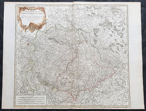
1757 Robert De Vaugondy Large Antique Map of Saxony, Meissen, Thuringia, Leipzig
- Title : Partie Meridionale Du Cercle De Haute Saxe...Par Le Sr. Robert
- Size: 26in x 20in (660mm x 510mm)
- Condition: (A+) Fine Condition
- Date : 1757
- Ref #: 41573
Description:
This large magnificent hand coloured original copper-plate engraved antique map of part of the Saxony region of Germany, centering on the district of Meissen & Thuringia and the city of Leipzig, by Robert De Vaugondy was published in the 1757 edition of De Vaugondys famous The Atlas Universel
General Definitions:
Paper thickness and quality: - Heavy and stable
Paper color : - off white
Age of map color: - Original & later
Colors used: - Blue, pink, red, green, yellow
General color appearance: - Authentic
Paper size: - 26in x 20in (660mm x 510mm)
Plate size: - 22in x 19 1/2in (560mm x 495mm)
Margins: - Min 1/2in (10mm)
Imperfections:
Margins: - None
Plate area: - None
Verso: - None
Background:
Saxony is a landlocked federal state of Germany, bordering the federal states of Brandenburg, Saxony Anhalt, Thuringia, and Bavaria, as well as the countries of Poland and the Czech Republic. Its capital is Dresden, and its largest city is Leipzig.
Saxony is the 10th-largest of Germany\'s 16 states, with an area of 18,413 square kilometres (7,109 sq mi), and the sixth-most populous, with 4 million people.
The history of the state of Saxony spans more than a millennium. It has been a medieval duchy, an electorate of the Holy Roman Empire, a kingdom, and twice a republic.
The area of the modern state of Saxony should not be confused with Old Saxony, the area inhabited by Saxons. Old Saxony corresponds roughly to the modern German states of Lower Saxony, Saxony-Anhalt, and the Westphalian part of North Rhine-Westphalia.
The territory of the Free State of Saxony became part of the Holy Roman Empire by the 10th century, when the dukes of Saxony were also kings (or emperors) of the Holy Roman Empire, comprising the Ottonian, or Saxon, Dynasty. Around this time, the Billungs, a Saxon noble family, received extensive fields in Saxony. The emperor eventually gave them the title of dukes of Saxony. After Duke Magnus died in 1106, causing the extinction of the male line of Billungs, oversight of the duchy was given to Lothar of Supplinburg, who also became emperor for a short time.
In 1137, control of Saxony passed to the Guelph dynasty, descendants of Wulfhild Billung, eldest daughter of the last Billung duke, and the daughter of Lothar of Supplinburg. In 1180 large portions west of the Weser were ceded to the Bishops of Cologne, while some central parts between the Weser and the Elbe remained with the Guelphs, becoming later the Duchy of Brunswick-Lüneburg. The remaining eastern lands, together with the title of Duke of Saxony, passed to an Ascanian dynasty (descended from Eilika Billung, Wulfhild\'s younger sister) and were divided in 1260 into the two small states of Saxe-Lauenburg and Saxe-Wittenberg. The former state was also named Lower Saxony, the latter Upper Saxony, thence the later names of the two Imperial Circles Saxe-Lauenburg and Saxe-Wittenberg. Both claimed the Saxon electoral privilege for themselves, but the Golden Bull of 1356 accepted only Wittenberg\'s claim, with Lauenburg nevertheless continuing to maintain its claim. In 1422, when the Saxon electoral line of the Ascanians became extinct, the Ascanian Eric V of Saxe-Lauenburg tried to reunite the Saxon duchies.
However, Sigismund, King of the Romans, had already granted Margrave Frederick IV the Warlike of Meissen (House of Wettin) an expectancy of the Saxon electorate in order to remunerate his military support. On 1 August 1425 Sigismund enfeoffed the Wettinian Frederick as Prince-Elector of Saxony, despite the protests of Eric V. Thus the Saxon territories remained permanently separated. The Electorate of Saxony was then merged with the much bigger Wettinian Margraviate of Meissen, however using the higher-ranking name Electorate of Saxony and even the Ascanian coat-of-arms for the entire monarchy. Thus Saxony came to include Dresden and Meissen. In the 18th and 19th centuries Saxe-Lauenburg was colloquially called the Duchy of Lauenburg, which in 1876 merged with Prussia as the Duchy of Lauenburg district.
Saxony-Wittenberg, in modern Saxony-Anhalt, became subject to the margravate of Meissen, ruled by the Wettin dynasty in 1423. This established a new and powerful state, occupying large portions of the present Free State of Saxony, Thuringia, Saxony-Anhalt and Bavaria (Coburg and its environs). Although the centre of this state was far to the southeast of the former Saxony, it came to be referred to as Upper Saxony and then simply Saxony, while the former Saxon territories were now known as Lower Saxony.
In 1485, Saxony was split. A collateral line of the Wettin princes received what later became Thuringia and founded several small states there (see Ernestine duchies). The remaining Saxon state became still more powerful and was known in the 18th century for its cultural achievements, although it was politically weaker than Prussia and Austria, states which oppressed Saxony from the north and south, respectively.
Between 1697 and 1763, the Electors of Saxony were also elected Kings of Poland in personal union.
In 1756, Saxony joined a coalition of Austria, France and Russia against Prussia. Frederick II of Prussia chose to attack preemptively and invaded Saxony in August 1756, precipitating the Third Silesian War (part of the Seven Years\' War). The Prussians quickly defeated Saxony and incorporated the Saxon army into the Prussian army. At the end of the Seven Years\' War, Saxony recovered its independence in the 1763 Treaty of Hubertusburg.
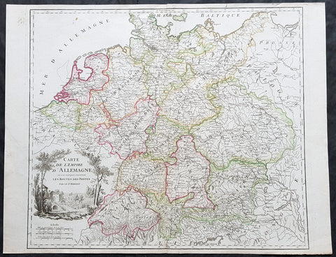
1757 Robert De Vaugondy Large Antique Map of the German States, Bohemia, Austria
- Title : Carte De L Empire D Allemagne..Les Routes Des Postes
- Size: 26in x 19 1/2in (660mm x 495mm)
- Condition: (A+) Fine Condition
- Date : 1757
- Ref #: 41567
Description:
This large magnificent hand coloured original copper-plate engraved antique map of various individual states of Germany including Austria, Bohemia, Switzerland & The Netherlands by Robert De Vaugondy was published in the 1757 edition of De Vaugondys famous The Atlas Universel
General Definitions:
Paper thickness and quality: - Heavy and stable
Paper color : - off white
Age of map color: - Original & later
Colors used: - Blue, pink, red, green, yellow
General color appearance: - Authentic
Paper size: - 26in x 19 1/2in (660mm x 495mm)
Plate size: - 22 1/2in x 19 1/2in (570mm x 495mm)
Margins: - Min 1/4in (5mm)
Imperfections:
Margins: - None
Plate area: - None
Verso: - None
Background:
In the 18th century, the Holy Roman Empire consisted of approximately 1,800 territories. The elaborate legal system initiated by a series of Imperial Reforms (approximately 1450–1555) created the Imperial Estates and provided for considerable local autonomy among ecclesiastical, secular, and hereditary states, reflected in Imperial Diet. The House of Habsburg held the imperial crown from 1438 until the death of Charles VI in 1740. Having no male heirs, he had convinced the Electors to retain Habsburg hegemony in the office of the emperor by agreeing to the Pragmatic Sanction. This was finally settled through the War of Austrian Succession; in the Treaty of Aix-la-Chapelle, Charles VI\'s daughter Maria Theresa ruled the Empire as Empress Consort when her husband, Francis I, became Holy Roman Emperor. From 1740, the dualism between the Austrian Habsburg Monarchy and the Kingdom of Prussia dominated the German history.
In 1772, then again in 1793 and 1795, the two dominant German states of Prussia and Austria, along with the Russian Empire, agreed to the Partitions of Poland; dividing among themselves the lands of the Polish–Lithuanian Commonwealth. As a result of the partitions, millions of Polish speaking inhabitants fell under the rule of the two German monarchies. However, the annexed territories though incorporated into the Kingdom of Prussia and the Habsburg Realm, were not legally considered as a part of the Holy Roman Empire. During the period of the French Revolutionary Wars, along with the arrival of the Napoleonic era and the subsequent final meeting of the Imperial Diet, most of the secular Free Imperial Cities were annexed by dynastic territories; the ecclesiastical territories were secularised and annexed. In 1806 the Imperium was dissolved; many German states, particularly the Rhineland states, fell under the influence of France. Until 1815, France, Russia, Prussia and the Habsburgs (Austria) competed for hegemony in the German states during the Napoleonic Wars
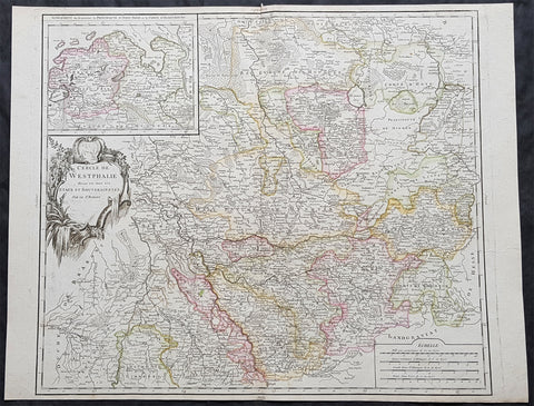
1757 Robert De Vaugondy Large Antique Map of The State of Westphalia, Germany
- Title : Cercle De Westpahlia.......Par Le Sr. Robert
- Size: 26in x 20in (660mm x 510mm)
- Condition: (A+) Fine Condition
- Date : 1757
- Ref #: 41570
Description:
This large magnificent hand coloured original copper-plate engraved antique map of the German State of Westphalia by Robert De Vaugondy was published in the 1757 edition of De Vaugondys famous The Atlas Universel
General Definitions:
Paper thickness and quality: - Heavy and stable
Paper color : - off white
Age of map color: - Original & later
Colors used: - Blue, pink, red, green, yellow
General color appearance: - Authentic
Paper size: - 26in x 20in (660mm x 510mm)
Plate size: - 25in x 19in (635mm x 485mm)
Margins: - Min 1/2in (10mm)
Imperfections:
Margins: - None
Plate area: - None
Verso: - None
Background:
Westphalia is a region in northwestern Germany and one of the three historic parts of the state of North Rhine-Westphalia.
Westphalia is known for the 1648 Peace of Westphalia which ended the Thirty Years War, as the two treaties were signed in Münster and Osnabrück.
It is one of the regions that were part of all incarnations of the German state since the Early Middle Ages: the Holy Roman Empire, the Confederation of the Rhine, the German Confederation, the North German Confederation, the German Empire, the Weimar Republic and National Socialist Germany. After World War II it was a part of the British occupation zone which merged with the American zone to become the Bizone in 1947 and again merged with the French zone to become the Trizone in 1948. The current Federal Republic of Germany was founded on these territories making Westphalia a part of West Germany. It is a part of united Germany since 1990.
Along with Eastphalia, Angria and Nordalbingia, Westphalia (Westfalahi) was originally a district of the Duchy of Saxony. At the time, large portions of its territory in the north lay in what today is Lower Saxony. Following the deposition of the Saxon duke Henry the Lion in 1180 and the subsequent belittlement of the duchy, Westphalia was elevated to a duchy in its own right by Emperor Barbarossa. The Duchy of Westphalia comprised only a small area south of the Lippe River.
Modern Westphalia was a part of the Lower Rhenish–Westphalian Circle of the Holy Roman Empire, which comprised territories of Lower Lorraine, Frisia and parts of the former Duchy of Saxony.
As a result of the Protestant Reformation, there was no dominant religion in Westphalia. Roman Catholicism and Lutheranism were on a relatively equal footing. Lutheranism was strong in the eastern and northern parts with numerous free churches. Münster and especially Paderborn were thought of to be Catholic. Osnabrück was divided almost equally between Catholicism and Protestantism.
Parts of Westphalia came under Brandenburg-Prussian control during the 17th and 18th centuries, but most of it remained divided by duchies and other areas of feudal power. The Peace of Westphalia of 1648, signed in Münster and Osnabrück, ended the Thirty Years\' War. The concept of nation-state sovereignty resulting from the treaty became known as Westphalian sovereignty.
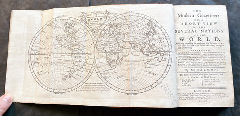
1759 Thomas Salmon Modern Gazetteer Antique Atlas with 7 Maps by Thomas Kitchin
- Title : The Modern Gazetteer: or a short View of the Severla Nations of the World.
- Ref : 17062
- Size: 16mo (7in x 5in)
- Date : 1759
- Condition: (A+) Fine Condition
Description:
This original antique Atlas The modern gazetteer: or, a short view of the several nations of the world, an early encyclopedia and atlas, with information on all parts of the known world at the time, was published by Thomas Salmon in 1759.
The Atlas is complete as called for and contains 7 maps by the famous English cartographer Thomas Kitchin:
1. World map - (12in x 7in 310mm x 180mm)
2. Africa - (8in x 7in 215mm x 180mm)
3. North America - (8in x 7in 215mm x 180mm)
4. South America - (8in x 7in 215mm x 180mm)
5. Asia - (8in x 7in 215mm x 180mm)
6. Europe - (8in x 7in 215mm x 180mm)
7. Germany - (8in x 7in 215mm x 180mm)
Atlas is in fine condition with beautiful and leather spine and boards. Light aging internally, folds as issued to maps.
General Definitions:
Paper thickness and quality: - Heavy and stable
Paper color : - off white
Age of map color: -
Colors used: -
General color appearance: -
Paper size: - 16mo (7in x 5in)
Plate size: - 16mo (7in x 5in)
Margins: - Min 1/2in (12mm)
Imperfections:
Margins: - None
Plate area: - None
Verso: - None
Background:
Thomas Kitchin 1718 - 84 was a London based engraver, cartographer, and publisher. He was born in London to a hat-dyer of the same name. At 14, Kitchin apprenticed under Emanuel Bowen, under whom he mastered the art of engraving. He married Bowen daughter, Sarah Bowen, and later inherited much of his preceptor\\\'s prosperous business. Their son, Thomas Bowen Kitchin, also an engraver joined the family business, which thereafter published in Thomas Kitchin and Son. From 1858 or so Kitchin was the engraver to the Duke of York, and from about 1773 acquired the title, \\\'Royal Hydrographer to King George III.\\\' He is responsible for numerous maps published in the The Star, Gentleman\\\'s Magazine, and London Magazine, as well as partnering with, at various times, with Thomas Jefferys, Emmanuel Bowen, Thomas Hinton, Issac Tayor, Andrew Dury, John Rocque, Louis de la Rochette, and Alexander Hogg, among others. Kitchin passed his business on to his son, Thomas Bowen Kitchin, who continued to republish many of his maps well after his death. Kitchin\\\'s apprentices included George Rollos, Bryant Lodge, Thomas Bowen Kitchin, Samuel Turner Sparrow, John Page, and Francis Vivares.
Atlases by Thomas Kitchin include:
Maps for the London Magazine 1747- 60.
Small English Atlas (Jefferys) 1749 -1787.
Large English Atlas (Bowen) 1755-1787.
The Royal English Atlas 1762-1828.
England Illustrated 1764.
A General Atlas (Sayer and Bennett, Laurie and Whittle) 1768 - 1810 .
Kitchin\\\'s Pocket Atlas 1769.
Kitchin\\\'s English Atlas 1770.
Antiquities of England and Wales (Henry Boswell) 1786.
A New Universal Atlas (Laurie and Whittle) 1789 - 1799
Salmon, Thomas 1679 - 1767
Salmon was an English historical and geographical writer.
Born at Meppershall in Bedfordshire, and baptised there on 2 February 1679, was son of Thomas Salmon, by his wife Katherine, daughter of John Bradshaw; Nathanael Salmon was his elder brother. William Cole wrote that he wrote much of his work in Cambridge, where he ran a coffee house, and then moved to London. He told Cole that he had spent time at sea, and in both the East and West Indies for some time. He also travelled in Europe.
In 1739 - 40 Salmon accompanied George Anson on his voyage round the world. He died on 20 January 1767.
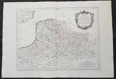
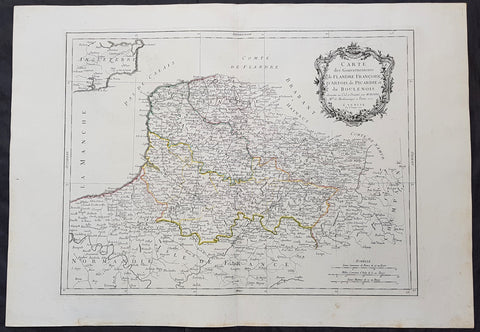
1777 F. Santini Antique Map Flanders Artois Hainaut Picardy Regions of Belgium
- Title : Carte Des Gouvernements de Flandre Francois d Artois de Picardie et du Boulenois...P Santini...1777
- Size: 30in x 21in (760mm x 535mm)
- Condition: (A+) Fine Condition
- Date : 1777
- Ref #: 50221
Description:
This large magnificent original copper-plate engraved antique map of Belgium and parts of Northern France made up of the provinces of Flanders, Artois, Hainaut, Picardy was engraved in 1777 - the date is engraved in the title cartouche - after Rigobert Bonne in 1771 and was published by Francois Santini (active 1776-84) in his 2 volume edition of Atlas Universal 1776-84.. (Ref: Tooley; M&B)
General Definitions:
Paper thickness and quality: - Heavy and stable
Paper color : - off white
Age of map color: - Original
Colors used: - Blue, pink, red, green, yellow
General color appearance: - Authentic
Paper size: - 30in x 21in (760mm x 535mm)
Plate size: - 23in x 18in (585mm x 460mm)
Margins: - Min 2in (50mm)
Imperfections:
Margins: - None
Plate area: - None
Verso: - None
Background:
Belgium officially the Kingdom of Belgium, is a country in Western Europe bordered by France, the Netherlands, Germany and Luxembourg.
Historically, Belgium was part of an area known as the Low Countries, a somewhat larger region than the current Benelux group of states that also included parts of northern France and western Germany. Its name is derived from the Latin word Belgica, after the Roman province of Gallia Belgica. From the end of the Middle Ages until the 17th century, the area of Belgium was a prosperous and cosmopolitan centre of commerce and culture. Between the 16th and early 19th centuries, Belgium served as the battleground between many European powers, earning the moniker the Battlefield of Europe, a reputation strengthened by both world wars. The country emerged in 1830 following the Belgian Revolution when it seceded from the Netherlands.
The Eighty Years War (1568–1648) divided the Low Countries into the northern United Provinces (Belgica Foederata in Latin, the Federated Netherlands) and the Southern Netherlands (Belgica Regia, the Royal Netherlands). The latter were ruled successively by the Spanish (Spanish Netherlands) and the Austrian Habsburgs (Austrian Netherlands) and comprised most of modern Belgium. This was the theatre of most Franco-Spanish and Franco-Austrian wars during the 17th and 18th centuries.
Following the campaigns of 1794 in the French Revolutionary Wars, the Low Countries—including territories that were never nominally under Habsburg rule, such as the Prince-Bishopric of Liège—were annexed by the French First Republic, ending Austrian rule in the region. The reunification of the Low Countries as the United Kingdom of the Netherlands occurred at the dissolution of the First French Empire in 1815, after the defeat of Napoleon.
1777 F. Santini Antique Map Flanders Artois Hainaut Picardy Regions of Belgium
- Title : Carte Des Gouvernements de Flandre Francois d Artois de Picardie et du Boulenois...P Santini...1777
- Size: 30in x 21in (760mm x 535mm)
- Condition: (A+) Fine Condition
- Date : 1777
- Ref #: 50219
Description:
This large magnificent original copper-plate engraved antique map of Belgium and parts of Northern France made up of the provinces of Flanders, Artois, Hainaut, Picardy was engraved in 1777 - the date is engraved in the title cartouche - after Rigobert Bonne in 1771 and was published by Francois Santini (active 1776-84) in his 2 volume edition of Atlas Universal 1776-84.. (Ref: Tooley; M&B)
General Definitions:
Paper thickness and quality: - Heavy and stable
Paper color : - off white
Age of map color: - Original
Colors used: - Blue, pink, red, green, yellow
General color appearance: - Authentic
Paper size: - 30in x 21in (760mm x 535mm)
Plate size: - 23in x 18in (585mm x 460mm)
Margins: - Min 2in (50mm)
Imperfections:
Margins: - None
Plate area: - None
Verso: - None
Background:
Belgium officially the Kingdom of Belgium, is a country in Western Europe bordered by France, the Netherlands, Germany and Luxembourg.
Historically, Belgium was part of an area known as the Low Countries, a somewhat larger region than the current Benelux group of states that also included parts of northern France and western Germany. Its name is derived from the Latin word Belgica, after the Roman province of Gallia Belgica. From the end of the Middle Ages until the 17th century, the area of Belgium was a prosperous and cosmopolitan centre of commerce and culture. Between the 16th and early 19th centuries, Belgium served as the battleground between many European powers, earning the moniker the Battlefield of Europe, a reputation strengthened by both world wars. The country emerged in 1830 following the Belgian Revolution when it seceded from the Netherlands.
The Eighty Years War (1568–1648) divided the Low Countries into the northern United Provinces (Belgica Foederata in Latin, the Federated Netherlands) and the Southern Netherlands (Belgica Regia, the Royal Netherlands). The latter were ruled successively by the Spanish (Spanish Netherlands) and the Austrian Habsburgs (Austrian Netherlands) and comprised most of modern Belgium. This was the theatre of most Franco-Spanish and Franco-Austrian wars during the 17th and 18th centuries.
Following the campaigns of 1794 in the French Revolutionary Wars, the Low Countries—including territories that were never nominally under Habsburg rule, such as the Prince-Bishopric of Liège—were annexed by the French First Republic, ending Austrian rule in the region. The reunification of the Low Countries as the United Kingdom of the Netherlands occurred at the dissolution of the First French Empire in 1815, after the defeat of Napoleon.
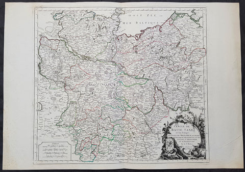
1778 Santini Antique Map Lower Saxon Circle Germany, Holstien Bremen Mecklenburg
- Title : Cercle de Basse Saxe on sont distingues Les Etats de Brunswich Les Duches De Holstien...Par L Sr Robert....A Venise...P Santini...1778
- Date : 1778
- Condition: (A+) Fine Condition
- Ref: 50203
- Size: 30in x 21in (760mm x 535mm)
Description:
This large magnificent original copper-plate engraved antique map of The Lower Saxon Circle of Northern Germany, was engraved in 1778 - the date is engraved in the title cartouche - after Robert De Vaugondy and was published by Francois Santini (active 1776-84) in his 2 volume edition of Atlas Universal 1776-84. (Ref: Tooley; M&B)
General Definitions:
Paper thickness and quality: - Heavy and stable
Paper color : - off white
Age of map color: - Original
Colors used: - Blue, pink, red, green, yellow
General color appearance: - Authentic
Paper size: - 30in x 21in (760mm x 535mm)
Plate size: - 22in x 19 1/2in (560mm x 495mm)
Margins: - Min 1in (25mm)
Imperfections:
Margins: - None
Plate area: - None
Verso: - None
Background:
The Lower Saxon Circle was an Imperial Circle of the Holy Roman Empire. It covered much of the territory of the medieval Duchy of Saxony (except for Westphalia), and was originally called the Saxon Circle (German: Sächsischer Kreis) before later being better differentiated from the Upper Saxon Circle by the more specific name.
An unusual aspect of this circle was that, at various times, the kings of Denmark (in Holstein), Great Britain (in Hanover) and Sweden (in Bremen) were all Princes of a number of Imperial States.
The Lower Saxon Circle included the easternmost part of current Lower Saxony, the northernmost part of Saxony-Anhalt (excluding the Altmark), Mecklenburg, Holstein (excluding Dithmarschen), Hamburg, Bremen, in addition to small areas in Brandenburg and Thuringia. For the most part it was a continuous territory with the exception of small enclaves like Halle and Jüterbog. Nordhausen and Mühlhausen were also areas outside the continuous portion of the imperial circle. Within the circle was the Archbishopric of Verden, which was in personal union with the Archbishopric of Bremen since 1502. The Counties of Schaumburg and Spiegelberg were also part of the personal union, but they were not a part of the Lower Saxon Circle.
By the downfall of the Holy Roman Empire, the circle was 1 240 square miles large, with 2 120 000 inhabitants. With respect to religion, almost all the citizens were Protestant. The exception was the partially Catholic Bishopric of Hildesheim.
During the Early Modern period the Holy Roman Empire was divided into Imperial Circles administrative groupings whose primary purposes were the organization of common defensive structure and the collection of imperial taxes. They were also used as a means of organization within the Imperial Diet and the Imperial Chamber Court. Each circle had a Circle Diet, although not every member of the Circle Diet would hold membership of the Imperial Diet as well.
Six Imperial Circles were introduced at the Diet of Augsburg in 1500. In 1512, three more circles were added, and the large Saxon Circle was split into two, so that from 1512 until the collapse of the Holy Roman Empire in the Napoleonic era, there were ten Imperial Circles. The Crown of Bohemia, the Swiss Confederacy and Italy remained unencircled, as did various minor territories which held imperial immediacy.
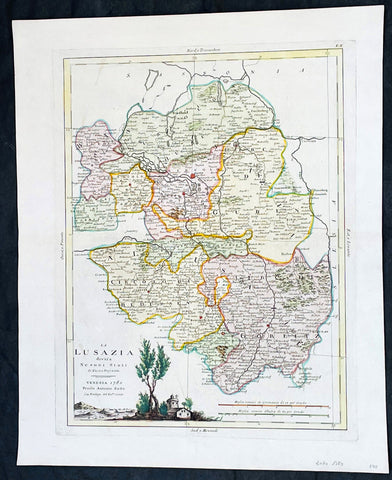
1780 Antonio Zatta Antique Map of The Lusatia Region Germany, Poland & Czech Rep
- Title : La Lusazia divisa ne suoi stati di nuova projezione
- Ref #: 35638
-
Condition: (A+) Fine Condition
- Size: 19in x 15 1/2in (485mm x 395mm)
- Date : 1780
- Price: $149US
Description:
This original hand coloured copper plate engraved antique map of the ancient central European region of Lusatia in between Poland and Germany, and in the south, the Czech Republic by Antonio Zatta (fl. 1775-97) in 1780 - dated - was published in his Atlas Atlante Novissimo
General Definitions:
Paper thickness and quality: - Heavy and stable
Paper color : - off white
Age of map color: - Original
Colors used: - Yellow, green, blue, pink
General color appearance: - Authentic
Paper size: - 19in x 15 1/2in (485mm x 395mm)
Plate size: - 16in x 12 1/2in (405mm x 315mm)
Margins: - Min 1in (25mm)
Imperfections:
Margins: - None
Plate area: - None
Verso: - None
Background:
Lusatia is a historical region in Central Europe, split between Germany and Poland. Lusatia stretches from the Bóbr and Kwisa rivers in the east to the Pulsnitz and Black Elster rivers in the west, and is located within the German states of Saxony and Brandenburg as well as in the Polish voivodeships of Lower Silesia and Lubusz. Lusatia's central rivers are the Spree and the Lusatian Neisse, which constitutes the border between Germany and Poland since 1945 (Oder–Neisse line). The Lusatian Mountains (part of the Sudetes), separate Lusatia from Bohemia (Czech Republic) in the south. Lusatia is traditionally divided into Upper Lusatia (the hilly southern part) and Lower Lusatia (the flat northern part).
Please note all items auctioned are genuine, we do not sell reproductions. A Certificate of Authenticity (COA) can be issued on request.
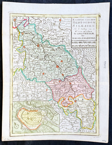
1791 J B Elwe Antique Map of Upper & Lower Silesia Poland Germany Czech Republic
- Title : Kaarteje Van Het Hertogdom Silesia
- Ref #: 35635
-
Condition: (A+) Fine Condition
- Size: 10 1/2in x 8in (265mm x 205mm)
- Date : 1791
- Price: $149US
Description:
This original hand coloured copper plate engraved antique map of Upper and Lower Silesia, with an inset map of the city of Breslau was engraved by G. Delisle for JB Elwe & D M Langeveld in 1791.
General Definitions:
Paper thickness and quality: - Heavy and stable
Paper color : - off white
Age of map color: - Original
Colors used: - Yellow, green, blue, pink
General color appearance: - Authentic
Paper size: - 10 1/2in x 8in (265mm x 205mm)
Plate size: - 10in x 7in (255mm x 180mm)
Margins: - Min 1/2in (12mm)
Imperfections:
Margins: - None
Plate area: - None
Verso: - None
Background:
Silesia is a historical region located in Central Europe, primarily encompassing areas that are now part of modern-day Poland, Germany, and the Czech Republic. Its history is complex and marked by various political and cultural shifts. Here is a concise overview of the history of Silesia:
Ancient and Medieval Periods:
The region of Silesia was inhabited by various tribes, including the Celts and later the Germanic tribes.
In the 9th century, the area came under the control of the emerging Polish state.
The region witnessed territorial conflicts between Poland, Bohemia (part of the Holy Roman Empire), and other neighboring powers throughout the medieval period.
Bohemian and Habsburg Rule:
In the 14th century, the Kingdom of Bohemia gained control over most of Silesia.
Silesia became part of the Habsburg Monarchy in the 16th century after the House of Habsburg inherited the Bohemian crown.
The Habsburgs ruled over Silesia for several centuries, during which the region experienced economic growth and cultural development.
Prussian and German Influence:
Following the War of the Austrian Succession (1740-1748), the Kingdom of Prussia, led by Frederick the Great, gained control of a significant portion of Silesia.
Prussia's annexation of Silesia sparked conflicts with Austria and contributed to the broader geopolitical tensions in Europe.
Silesia became an integral part of Prussia and later the German Empire, experiencing industrialization and urbanization during the 19th and early 20th centuries.
Post-World War I and World War II:
After Germany's defeat in World War I, the Treaty of Versailles (1919) redrew the borders of Europe, and the majority of Silesia was incorporated into the newly reestablished Poland.
The region witnessed significant ethnic and political tensions between its German and Polish populations.
Following World War II, the Potsdam Conference (1945) awarded most of Silesia to Poland, resulting in the expulsion of the German population and the resettlement of Poles.
Modern Period:
Since the end of World War II, Silesia has remained divided between Poland, Germany, and the Czech Republic.
The Polish part of Silesia, known as Upper Silesia, has become an important industrial and mining region.
The German and Czech parts of Silesia have experienced economic growth and cultural revitalization, with efforts to preserve the region's heritage.
Today, Silesia serves as a symbol of shared history and cultural diversity, with each country that possesses parts of the region contributing to its unique identity.
Elwe, J B
Johann Balthasar Probst, known as J.B. Elwe, was a German publisher and map seller who operated during the late 18th century. He was born in Nuremberg, Germany, in 1727 and later moved to Amsterdam, Netherlands, where he established himself as a prominent cartographer and publisher.
Elwe is known for publishing and distributing maps, atlases, and geographical works, including reprints and editions of earlier cartographic works by notable mapmakers such as Gerard Mercator, Abraham Ortelius, and Jodocus Hondius. He also produced his own maps and atlases, often based on the latest geographic knowledge of the time.
Elwe's publications were known for their decorative elements, including elaborate title cartouches, ornate borders, and vibrant hand coloring. His maps covered various regions, including Europe, Africa, Asia, and the Americas.
J.B. Elwe's cartographic business flourished during the late 18th century, and he gained a reputation for the quality and aesthetic appeal of his maps. However, precise details about his personal life and the extent of his contributions to cartography are not widely available.
Please note all items auctioned are genuine, we do not sell reproductions. A Certificate of Authenticity (COA) can be issued on request.
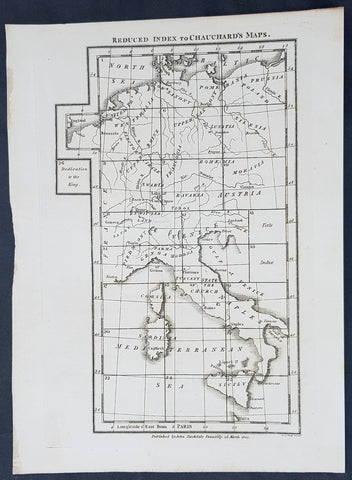
1800 Stockdale Original Antique Index Map of Capt Chauchards Maps Italy, Germany
- Title : Reduced Index to Chauchards Maps
- Size: 11 1/2in x 9in (290mm x 230mm)
- Ref #: 31148
- Date : 1800
- Condition: (A+) Fine Condition
Description:
This original copper-plate engraved antique index map to the 26 page map A general map of the empire of Germany, Holland, the Netherlands, Switzerland, the Grisons, Italy, Sicily, Corsica and Sardinia by Captain Chauchard published by John Stockdale in 1800 - dated. (Ref: Tooley; M&B)
General Definitions:
Paper thickness and quality: - Heavy and stable
Paper color : - off white
Age of map color: -
Colors used: -
General color appearance: -
Paper size: - 11 1/2in x 9in (290mm x 230mm)
Plate size: - 10 1/2in x 7in (265mm x 180mm)
Margins: - Min 1/2in (12mm)
Imperfections:
Margins: - None
Plate area: - None
Verso: - None
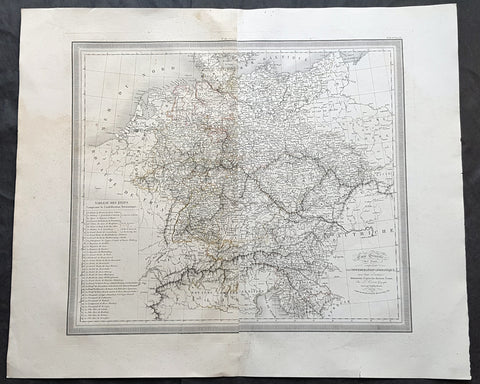
1824 Louis Vivien Large Antique Map of the Confederation of German States
- Title : Carte Generale de Etats compesantL Confederation Germanique...1824
- Size: 27 1/2in x 23in (700mm x 585mm)
- Condition: (A+) Fine Condition
- Date : 1824
- Ref #: 40713
Description:
This finely engraved original large antique map of the confederation of German states and central Europe, by Louis Vivien in his Elephant Folio atlas, Atlas Universal
General Definitions:
Paper thickness and quality: - Heavy and stable
Paper color : - off white
Age of map color: - Original
Colors used: - Blue, pink, yellow, green
General color appearance: - Authentic
Paper size: - 27 1/2in x 23in (700mm x 585mm)
Plate size: - 22in x 19in (560mm x 480mm)
Margins: - Min 2in (50mm)
Imperfections:
Margins: - Light soiling
Plate area: - None
Verso: - None
Background:
The German Confederation was an association of 39 German-speaking states in Central Europe (adding the mainly non-German speaking Kingdom of Bohemia and Duchy of Carniola), created by the Congress of Vienna in 1815 to coordinate the economies of separate German-speaking countries and to replace the former Holy Roman Empire, which had been dissolved in 1806. The German Confederation excluded German-speaking lands in the eastern portion of the Kingdom of Prussia (East Prussia, West Prussia and Posen), the German cantons of Switzerland, and Alsace within France which was majority German speaking.
The Confederation was weakened by rivalry between the Kingdom of Prussia and the Austrian Empire, revolution, and the inability of the multiple members to compromise. In 1848, revolutions by liberals and nationalists attempted to establish a unified German state with a progressive liberal constitution under the Frankfurt Convention. The ruling body, the Confederate Diet, was dissolved on 12 July 1848, but was re-established in 1850 after failed efforts to replace it.
The Confederation was finally dissolved after the Prussian victory in the Seven Weeks War over Austria in 1866. The dispute over which had the inherent right to rule German lands ended in favour of Prussia, leading to the creation of the North German Confederation under Prussian leadership in 1867, to which the eastern portions of the Kingdom of Prussia were added. A number of South German states remained independent until they joined the North German Confederation, which was renamed and proclaimed as the German Empire in 1871 for the now unified Germany with the Prussian king as emperor (Kaiser) after the victory over French Emperor Napoleon III in the Franco-Prussian War of 1870.
Most historians have judged the Confederation to have been weak and ineffective, as well as an obstacle to the creation of a German nation-state. However, the Confederation was designed to be weak, as it served the interests of the European Great Powers, especially member states Austria and Prussia.
Vivien, Louis 1802 - 1896
Louis Vivien , or Vivien de Saint-Martin was a French geographer who was born in Saint-Martin-de-Fontenay and died in Versailles, France in 1896.
He settled in Paris under the Restoration, and became known with his publication of the Electoral and Administrative Map in 1823 and his comprehensive Universal Atlas in 1825, collaborating with Jacques Bibliomappe -Charles Bailleul from 1828. Vivien was foremost a geographer but was also a publisher of works in other fields, including historical books on the General History of the French Revolution and the History of Napoleon. He also translated various English works, such as the novels of Walter Scott .
He also wrote the New Annals of Travels between 1845 and 1854 and briefly the French Athenaeum between 1847 & 1848. He contributed to numerous periodicals such as Le Constitutionnel, Revue contemporaine, Revue germanique & La Presse. He also wrote L Année géographique between 1863 and 1875 before passing the baton to G. Maunoir and Henri Duveyrier.
He is mainly known though, for his three cartographical works, A History of Geographical Discoveries, A New Dictionary of Universal Geography and the Universal Atlas of Geography. The first of these publications he completed after the 1848 Revolution with the latter two completed by Louis Rousselet and Franz Schrader.
Vivien was Honorary President of the Geographical Society, of which he was one of the founder members. He also laureate of the Academy of Inscriptions and Belles-Lettres as well as a member of the Asian Society , the Society of Ethnology along with a large number of learned societies and European academies.
Main works of Vivien de Saint-Martin
- General History of the French Revolution, the Empire, the Restoration, the Monarchy of 1830, up to and including 1841 (4 volumes in 2 volumes), Paris, Pourrat Brothers, 1841-1842.
- History of Napoleon and the Empire (2 volumes), Paris, Pourrat brothers, 1844.
- History of geographical discoveries of European nations in various parts of the world (2 volumes), Paris, Arthus-Bertrand, 1845-1846.
- Research on primitive populations and the oldest traditions of the Caucasus , Paris, Arthus-Bertrand, 1847.
- Studies of Ancient Geography and Asian Ethnography (2 volumes), Paris, Arthus-Bertrand, 1850-1852.
- Historical and geographical description of Asia Minor (2 volumes), Paris, Arthus-Bertrand, 1852.
- Study on the Greek and Latin Geography of India , Paris, Imperial Printing, 1858.
- Study on the geography and the primitive populations of north-west India, according to the Vedic hymns , Paris, Imprimerie impériale, 1860.
- North Africa in Greek and Roman antiquity, historical and geographical study , Paris, Imprimerie impériale, 1863.
- History of geography and geographical discoveries from the earliest times to the present day , Paris, Hachette, 1873.
- With Franz Schrader : Universal Atlas of Geography built from the original sources and the most recent documents , Paris, Hachette, 1876-1915.
- With Louis Rousselet : New dictionary of universal geography (9 volumes), Paris, Hachette, 1879-1900.

1845-63 John Gould Large Antique Print of Tree Kangaroo The Mammals of Australia
- Title : Dendrolagus Inustus, Mull....H C Richter del et lith....C Hullmandel Imp.
- Ref #: 93442
- Size: 22in x 15in (560mm x 385mm)
- Date : 1845–63
- Condition: (A+) Fine Condition
Description:
This large rare original hand coloured lithograph antique print of The Grizzled Tree Kangaroo, by the artist HC Richter was printed by Charles Joseph Hullmandel 1789 – 1850 in the famous Naturalists John Goulds The Mammals of Australiapublished between 1845–63.
General Definitions:
Paper thickness and quality: - Heavy and stable
Paper color : - off white
Age of map color: - Original
Colors used: - Blue, pink, red, green, yellow
General color appearance: - Authentic
Paper size: - 22in x 15in (560mm x 385mm)
Plate size: - 22in x 15in (560mm x 385mm)
Margins: - Min 1in (25mm)
Imperfections:
Margins: - Light age toning
Plate area: - None
Verso: - None
Background:
The Mammals of Australia is a three-volume work written and published by John Gould between 1845–63. It contains 182 illustrations by the author and its artist H. C. Richter. It was intended to be a complete survey of the novel species of mammals, such as the marsupials, discovered in the colonies of Australia.
The author, John Gould, best known for The Birds of Australia and other major works of ornithology, visited Australia in 1838. In his introduction, Gould says:.....It was not until I arrived in the country, and found myself surrounded by objects as strange as if I had been transported to another planet, that I conceived the idea of devoting a portion of my attention to the mammalian class of its extraordinary fauna......During his short stay he made observations on the natural history and employed his skills as a taxidermist to obtain specimens.
The publication of this major work by Gould followed his A Monograph of the Macropodidae or Family of Kangaroos in 1841. This work was the first comprehensive survey of Australian mammals, and gave an account of their classification and description. Gould also included the indigenous names for the species from the lists he made while in Australia. He used these names to make requests of the local peoples for his specimens, and recorded the regions where the names were used. This conserved a number of common names, such as dibbler (Parantechinus apicalis), which were later recommended by authorities.
The large lithographs reproduced the artwork of Richter, after the drawings and watercolours made in Australia by Gould and his wife, Elizabeth. (The contribution by Elizabeth Gould was uncredited). These were hand-coloured by a group of artists, led by Gabriel Bayfield, that required the completion of 26,572 plates. The illustrations produced during their visit to Australia were supplemented by the preserved specimens returned to England and detailed the characteristics of the species. These illustrations have become iconic images of the mammals of Australia. Among the best known of the illustrations from the work are the two of Thylacinus cynocephalus (Tasmanian tiger), copied since its publication and the most frequently reproduced, made more recognizable by Cascade Brewerys appropriation for its label in 1987. The government of Tasmania published a monochromatic reproduction of the same image in 1934, the author Louisa Anne Meredith also copied it for Tasmanian Friends and Foes (1881).
The Mammals of Australia was published by subscription in the format Imperial Folio; 13 parts in three volumes were issued from 1845 until 1863. To these the author added An Introduction to The Mammals of Australia (1863) in a separate work. This provided corrections and updates, a new preface, introduction, and a list of the mammals of the three volumes. The first two volumes were complete surveys of orders Marsupiata (marsupials), and, with Rodentia in the third, it formed the sum of known mammalian species of Australia. With the addition of those contained in the later Introduction the total of species described reached 166. The same work notes the exclusion of marine mammals such as whales from the volumes, but reprints a manuscript by Charles Coxen on the dugong.
Beyond the scientific value of this comprehensive survey, the document is cited in reference to its subjects conservation. Some of the species included in the work, such as Onychogalea lunata (crescent nailtail wallaby), have since succumbed to changes in land use since European colonisation.
The work was received with acclaim, but the high cost of production, especially of the coloured plates, reduced its accessibility. The original listed price was £41 for the complete set of volumes. The public curiosity for the unique fauna of Australia was met by this handsomely illustrated and comprehensive survey, and it spawned imitations in Australia. The curator of the Australian Museum, Gerard Krefft, produced the more affordable The Mammals of Australia (1871); intended for educational purposes and influenced by Goulds illustrations. Gracius Broinowskis abandoned work, Birds and Mammals of Australia (1884), so closely imitated the plates that an injunction was threatened by its publisher.
Gould, John FRS 1804 – 1881
Gould was an English ornithologist and bird artist. He published a number of monographs on birds, illustrated by plates that he produced with the assistance of his wife, Elizabeth Gould, and several other artists including Edward Lear, Henry Constantine Richter, Joseph Wolf and William Matthew Hart. He has been considered the father of bird study in Australia and the Gould League in Australia is named after him. His identification of the birds now nicknamed Darwins finches played a role in the inception of Darwins theory of evolution by natural selection. Goulds work is referenced in Charles Darwins book, On the Origin of Species.
Gould was born in Lyme Regis the first son of a gardener. He and the boy probably had a scanty education. Shortly afterwards his father obtained a position on an estate near Guildford, Surrey, and then in 1818 Gould became foreman in the Royal Gardens of Windsor. He was for some time under the care of J. T. Aiton, of the Royal Gardens of Windsor. The young Gould started training as a gardener, being employed under his father at Windsor from 1818 to 1824, and he was subsequently a gardener at Ripley Castle in Yorkshire. He became an expert in the art of taxidermy. In 1824 he set himself up in business in London as a taxidermist, and his skill helped him to become the first Curator and Preserver at the museum of the Zoological Society of London in 1827.
Goulds position brought him into contact with the countrys leading naturalists. This meant that he was often the first to see new collections of birds given to the Zoological Society of London. In 1830 a collection of birds arrived from the Himalayas, many not previously described. Gould published these birds in A Century of Birds from the Himalaya Mountains (1830–1832). The text was by Nicholas Aylward Vigors and the illustrations were drawn and lithographed by Goulds wife Elizabeth Coxen Gould. Most of Goulds work were rough sketches on paper from which other artists created the lithographic plates.
This work was followed by four more in the next seven years, including Birds of Europe in five volumes. It was completed in 1837; Gould wrote the text, and his clerk, Edwin Prince, did the editing. The plates were drawn and lithographed by Elizabeth Coxen Gould. A few of the illustrations were made by Edward Lear as part of his Illustrations of the Family of Psittacidae in 1832. Lear, however, was in financial difficulty, and he sold the entire set of lithographs to Gould. The books were published in a very large size, imperial folio, with magnificent coloured plates. Eventually 41 of these volumes were published, with about 3000 plates. They appeared in parts at £3 3s. a number, subscribed for in advance, and in spite of the heavy expense of preparing the plates, Gould succeeded in making his ventures pay, realising a fortune. This was a busy period for Gould who also published Icones Avium in two parts containing 18 leaves of bird studies on 54 cm plates as a supplement to his previous works. No further monographs were published as in 1838 he and his wife moved to Australia to work on the Birds of Australia. Shortly after their return to England, his wife died in 1841. Elizabeth Gould completed 84 plates for Birds of Australia before her death.
When Charles Darwin presented his mammal and bird specimens collected during the second voyage of HMS Beagle to the Zoological Society of London on 4 January 1837, the bird specimens were given to Gould for identification. He set aside his paying work and at the next meeting on 10 January reported that birds from the Galápagos Islands which Darwin had thought were blackbirds, gross-bills and finches were in fact a series of ground Finches which are so peculiar as to form an entirely new group, containing 12 species. This story made the newspapers. In March, Darwin met Gould again, learning that his Galápagos wren was another species of finch and the mockingbirds he had labelled by island were separate species rather than just varieties, with relatives on the South American mainland. Subsequently, Gould advised that the smaller southern Rhea specimen that had been rescued from a Christmas dinner was a separate species which he named Rhea darwinii, whose territory overlapped with the northern rheas. Darwin had not bothered to label his finches by island, but others on the expedition had taken more care. He now sought specimens collected by captain Robert FitzRoy and crewmen. From them he was able to establish that the species were unique to islands, an important step on the inception of his theory of evolution by natural selection. Goulds work on the birds was published between 1838 and 1842 in five numbers as Part 3 of Zoology of the Voyage of H.M.S. Beagle, edited by Charles Darwin. Elizabeth Gould illustrated all the plates for Part 3.
In 1838 the Goulds sailed to Australia, intending to study the birds of that country and be the first to produce a major work on the subject. They took with them the collector John Gilbert. They arrived in Tasmania in September, making the acquaintance of the governor Sir John Franklin and his wife. Gould and Gilbert collected on the island. In February 1839 Gould sailed to Sydney, leaving his pregnant wife with the Franklins. He travelled to his brother-in-laws station at Yarrundi, spending his time searching for bowerbirds in the Liverpool Range. In April he returned to Tasmania for the birth of his son. In May he sailed to Adelaide to meet Charles Sturt, who was preparing to lead an expedition to the Murray River. Gould collected in the Mount Lofty range, the Murray Scrubs and Kangaroo Island, returning again to Hobart in July. He then travelled with his wife to Yarrundi. They returned home to England in May 1840.
The result of the trip was The Birds of Australia (1840–48). It included a total of 600 plates in seven volumes; 328 of the species described were new to science and named by Gould. He also published A Monograph of the Macropodidae, or Family of Kangaroos (1841–1842) and the three volume work The Mammals of Australia (1849–1861).
Elizabeth died in 1841 after the birth of their eighth child, Sarah, and Goulds books subsequently used illustrations by a number of artists, including Henry Constantine Richter, William Matthew Hart and Joseph Wolf.
Throughout his professional life Gould had a strong interest in hummingbirds. He accumulated a collection of 320 species, which he exhibited at the Great Exhibition of 1851. Despite his interest, Gould had never seen a live hummingbird. In May 1857 he travelled to the United States with his second son, Charles. He arrived in New York too early in the season to see hummingbirds in that city, but on 21 May 1857, in Bartrams Gardens in Philadelphia, he finally saw his first live one, a ruby-throated hummingbird. He then continued to Washington D.C. where he saw large numbers in the gardens of the Capitol. Gould attempted to return to England with live specimens, but, as he was not aware of the conditions necessary to keep them, they only lived for two months at most.
Gould published: A Monograph of the Trochilidae or Humming Birds with 360 plates (1849–61); The Mammals of Australia (1845–63), Handbook to the Birds of Australia (1865), The Birds of Asia (1850–83), The Birds of Great Britain (1862–73) and The Birds of New Guinea and the adjacent Papuan Islands (1875–88).
The University of Glasgow, which owns a copy of Birds of Great Britain, describes John Gould as the greatest figure in bird illustration after Audubon, and auctioneers Sotherans describe the work as Goulds pride and joy.
Gould had already published some of the illustrations in Birds of Europe, but Birds of Great Britain represents a development of his aesthetic style in which he adds illustrations of nests and young on a large scale.
Sotherans Co. reports that Gould published the book himself, producing 750 copies, which remain sought after both as complete volumes, and as individual plates, currently varying in price from £450 – £850. The University of Glasgow records that the volumes were issued in London in 25 parts, to make the complete set, between 1863 and 1873, and each set contained 367 coloured lithographs.
Gould undertook an ornithological tour of Scandinavia in 1856, in preparation for the work, taking with him the artist Henry Wolf who drew 57 of the plates from Goulds preparatory sketches. According to The University of Glasgow Goulds skill was in rapidly producing rough sketches from nature (a majority of the sketches were drawn from newly killed specimens) capturing the distinctiveness of each species. Gould then oversaw the process whereby his artists worked his sketches up into the finished drawings, which were made into coloured lithographs by engraver William Hart.
There were problems: the stone engraving of the snowy owl in volume I was dropped and broken at an early stage in the printing. Later issues of this plate show evidence of this damage and consequently the early issue – printed before the accident – are considered more desirable.
The lithographs were hand coloured. In the introduction for the work, Gould states every sky with its varied tints and every feather of each bird were coloured by hand; and when it is considered that nearly two hundred and eighty thousand illustrations in the present work have been so treated, it will most likely cause some astonishment to those who give the subject a thought.
The work has gathered critical acclaim: according to Mullens and Swann, Birds of Great Britain is the most sumptuous and costly of British bird books, whilst Wood describes it as a magnificent work. Isabella Tree writes that it was seen – perhaps partly because its subject was British, as the culmination of [his] ... genius

1845-63 John Gould Large Antique Print The Mammals of Australia - Tree Kangaroo
- Title : Dendrolagus Ursinus, Mull....H C Richter del et lith....C Hullmandel Imp.
- Ref #: 93441
- Size: 22in x 15in (560mm x 385mm)
- Date : 1845–63
- Condition: (A+) Fine Condition
Description:
This large rare original hand coloured lithograph antique print of The Ursine Tree Kangaroo, by the artist HC Richter was printed by Charles Joseph Hullmandel 1789 – 1850 in the famous Naturalists John Goulds The Mammals of Australiapublished between 1845–63.
General Definitions:
Paper thickness and quality: - Heavy and stable
Paper color : - off white
Age of map color: - Original
Colors used: - Blue, pink, red, green, yellow
General color appearance: - Authentic
Paper size: - 22in x 15in (560mm x 385mm)
Plate size: - 22in x 15in (560mm x 385mm)
Margins: - Min 1in (25mm)
Imperfections:
Margins: - Light age toning
Plate area: - None
Verso: - None
Background:
The Mammals of Australia is a three-volume work written and published by John Gould between 1845–63. It contains 182 illustrations by the author and its artist H. C. Richter. It was intended to be a complete survey of the novel species of mammals, such as the marsupials, discovered in the colonies of Australia.
The author, John Gould, best known for The Birds of Australia and other major works of ornithology, visited Australia in 1838. In his introduction, Gould says:.....It was not until I arrived in the country, and found myself surrounded by objects as strange as if I had been transported to another planet, that I conceived the idea of devoting a portion of my attention to the mammalian class of its extraordinary fauna......During his short stay he made observations on the natural history and employed his skills as a taxidermist to obtain specimens.
The publication of this major work by Gould followed his A Monograph of the Macropodidae or Family of Kangaroos in 1841. This work was the first comprehensive survey of Australian mammals, and gave an account of their classification and description. Gould also included the indigenous names for the species from the lists he made while in Australia. He used these names to make requests of the local peoples for his specimens, and recorded the regions where the names were used. This conserved a number of common names, such as dibbler (Parantechinus apicalis), which were later recommended by authorities.
The large lithographs reproduced the artwork of Richter, after the drawings and watercolours made in Australia by Gould and his wife, Elizabeth. (The contribution by Elizabeth Gould was uncredited). These were hand-coloured by a group of artists, led by Gabriel Bayfield, that required the completion of 26,572 plates. The illustrations produced during their visit to Australia were supplemented by the preserved specimens returned to England and detailed the characteristics of the species. These illustrations have become iconic images of the mammals of Australia. Among the best known of the illustrations from the work are the two of Thylacinus cynocephalus (Tasmanian tiger), copied since its publication and the most frequently reproduced, made more recognizable by Cascade Brewerys appropriation for its label in 1987. The government of Tasmania published a monochromatic reproduction of the same image in 1934, the author Louisa Anne Meredith also copied it for Tasmanian Friends and Foes (1881).
The Mammals of Australia was published by subscription in the format Imperial Folio; 13 parts in three volumes were issued from 1845 until 1863. To these the author added An Introduction to The Mammals of Australia (1863) in a separate work. This provided corrections and updates, a new preface, introduction, and a list of the mammals of the three volumes. The first two volumes were complete surveys of orders Marsupiata (marsupials), and, with Rodentia in the third, it formed the sum of known mammalian species of Australia. With the addition of those contained in the later Introduction the total of species described reached 166. The same work notes the exclusion of marine mammals such as whales from the volumes, but reprints a manuscript by Charles Coxen on the dugong.
Beyond the scientific value of this comprehensive survey, the document is cited in reference to its subjects conservation. Some of the species included in the work, such as Onychogalea lunata (crescent nailtail wallaby), have since succumbed to changes in land use since European colonisation.
The work was received with acclaim, but the high cost of production, especially of the coloured plates, reduced its accessibility. The original listed price was £41 for the complete set of volumes. The public curiosity for the unique fauna of Australia was met by this handsomely illustrated and comprehensive survey, and it spawned imitations in Australia. The curator of the Australian Museum, Gerard Krefft, produced the more affordable The Mammals of Australia (1871); intended for educational purposes and influenced by Goulds illustrations. Gracius Broinowskis abandoned work, Birds and Mammals of Australia (1884), so closely imitated the plates that an injunction was threatened by its publisher.
Gould, John FRS 1804 – 1881
Gould was an English ornithologist and bird artist. He published a number of monographs on birds, illustrated by plates that he produced with the assistance of his wife, Elizabeth Gould, and several other artists including Edward Lear, Henry Constantine Richter, Joseph Wolf and William Matthew Hart. He has been considered the father of bird study in Australia and the Gould League in Australia is named after him. His identification of the birds now nicknamed Darwins finches played a role in the inception of Darwins theory of evolution by natural selection. Goulds work is referenced in Charles Darwins book, On the Origin of Species.
Gould was born in Lyme Regis the first son of a gardener. He and the boy probably had a scanty education. Shortly afterwards his father obtained a position on an estate near Guildford, Surrey, and then in 1818 Gould became foreman in the Royal Gardens of Windsor. He was for some time under the care of J. T. Aiton, of the Royal Gardens of Windsor. The young Gould started training as a gardener, being employed under his father at Windsor from 1818 to 1824, and he was subsequently a gardener at Ripley Castle in Yorkshire. He became an expert in the art of taxidermy. In 1824 he set himself up in business in London as a taxidermist, and his skill helped him to become the first Curator and Preserver at the museum of the Zoological Society of London in 1827.
Goulds position brought him into contact with the countrys leading naturalists. This meant that he was often the first to see new collections of birds given to the Zoological Society of London. In 1830 a collection of birds arrived from the Himalayas, many not previously described. Gould published these birds in A Century of Birds from the Himalaya Mountains (1830–1832). The text was by Nicholas Aylward Vigors and the illustrations were drawn and lithographed by Goulds wife Elizabeth Coxen Gould. Most of Goulds work were rough sketches on paper from which other artists created the lithographic plates.
This work was followed by four more in the next seven years, including Birds of Europe in five volumes. It was completed in 1837; Gould wrote the text, and his clerk, Edwin Prince, did the editing. The plates were drawn and lithographed by Elizabeth Coxen Gould. A few of the illustrations were made by Edward Lear as part of his Illustrations of the Family of Psittacidae in 1832. Lear, however, was in financial difficulty, and he sold the entire set of lithographs to Gould. The books were published in a very large size, imperial folio, with magnificent coloured plates. Eventually 41 of these volumes were published, with about 3000 plates. They appeared in parts at £3 3s. a number, subscribed for in advance, and in spite of the heavy expense of preparing the plates, Gould succeeded in making his ventures pay, realising a fortune. This was a busy period for Gould who also published Icones Avium in two parts containing 18 leaves of bird studies on 54 cm plates as a supplement to his previous works. No further monographs were published as in 1838 he and his wife moved to Australia to work on the Birds of Australia. Shortly after their return to England, his wife died in 1841. Elizabeth Gould completed 84 plates for Birds of Australia before her death.
When Charles Darwin presented his mammal and bird specimens collected during the second voyage of HMS Beagle to the Zoological Society of London on 4 January 1837, the bird specimens were given to Gould for identification. He set aside his paying work and at the next meeting on 10 January reported that birds from the Galápagos Islands which Darwin had thought were blackbirds, gross-bills and finches were in fact a series of ground Finches which are so peculiar as to form an entirely new group, containing 12 species. This story made the newspapers. In March, Darwin met Gould again, learning that his Galápagos wren was another species of finch and the mockingbirds he had labelled by island were separate species rather than just varieties, with relatives on the South American mainland. Subsequently, Gould advised that the smaller southern Rhea specimen that had been rescued from a Christmas dinner was a separate species which he named Rhea darwinii, whose territory overlapped with the northern rheas. Darwin had not bothered to label his finches by island, but others on the expedition had taken more care. He now sought specimens collected by captain Robert FitzRoy and crewmen. From them he was able to establish that the species were unique to islands, an important step on the inception of his theory of evolution by natural selection. Goulds work on the birds was published between 1838 and 1842 in five numbers as Part 3 of Zoology of the Voyage of H.M.S. Beagle, edited by Charles Darwin. Elizabeth Gould illustrated all the plates for Part 3.
In 1838 the Goulds sailed to Australia, intending to study the birds of that country and be the first to produce a major work on the subject. They took with them the collector John Gilbert. They arrived in Tasmania in September, making the acquaintance of the governor Sir John Franklin and his wife. Gould and Gilbert collected on the island. In February 1839 Gould sailed to Sydney, leaving his pregnant wife with the Franklins. He travelled to his brother-in-laws station at Yarrundi, spending his time searching for bowerbirds in the Liverpool Range. In April he returned to Tasmania for the birth of his son. In May he sailed to Adelaide to meet Charles Sturt, who was preparing to lead an expedition to the Murray River. Gould collected in the Mount Lofty range, the Murray Scrubs and Kangaroo Island, returning again to Hobart in July. He then travelled with his wife to Yarrundi. They returned home to England in May 1840.
The result of the trip was The Birds of Australia (1840–48). It included a total of 600 plates in seven volumes; 328 of the species described were new to science and named by Gould. He also published A Monograph of the Macropodidae, or Family of Kangaroos (1841–1842) and the three volume work The Mammals of Australia (1849–1861).
Elizabeth died in 1841 after the birth of their eighth child, Sarah, and Goulds books subsequently used illustrations by a number of artists, including Henry Constantine Richter, William Matthew Hart and Joseph Wolf.
Throughout his professional life Gould had a strong interest in hummingbirds. He accumulated a collection of 320 species, which he exhibited at the Great Exhibition of 1851. Despite his interest, Gould had never seen a live hummingbird. In May 1857 he travelled to the United States with his second son, Charles. He arrived in New York too early in the season to see hummingbirds in that city, but on 21 May 1857, in Bartrams Gardens in Philadelphia, he finally saw his first live one, a ruby-throated hummingbird. He then continued to Washington D.C. where he saw large numbers in the gardens of the Capitol. Gould attempted to return to England with live specimens, but, as he was not aware of the conditions necessary to keep them, they only lived for two months at most.
Gould published: A Monograph of the Trochilidae or Humming Birds with 360 plates (1849–61); The Mammals of Australia (1845–63), Handbook to the Birds of Australia (1865), The Birds of Asia (1850–83), The Birds of Great Britain (1862–73) and The Birds of New Guinea and the adjacent Papuan Islands (1875–88).
The University of Glasgow, which owns a copy of Birds of Great Britain, describes John Gould as the greatest figure in bird illustration after Audubon, and auctioneers Sotherans describe the work as Goulds pride and joy.
Gould had already published some of the illustrations in Birds of Europe, but Birds of Great Britain represents a development of his aesthetic style in which he adds illustrations of nests and young on a large scale.
Sotherans Co. reports that Gould published the book himself, producing 750 copies, which remain sought after both as complete volumes, and as individual plates, currently varying in price from £450 – £850. The University of Glasgow records that the volumes were issued in London in 25 parts, to make the complete set, between 1863 and 1873, and each set contained 367 coloured lithographs.
Gould undertook an ornithological tour of Scandinavia in 1856, in preparation for the work, taking with him the artist Henry Wolf who drew 57 of the plates from Goulds preparatory sketches. According to The University of Glasgow Goulds skill was in rapidly producing rough sketches from nature (a majority of the sketches were drawn from newly killed specimens) capturing the distinctiveness of each species. Gould then oversaw the process whereby his artists worked his sketches up into the finished drawings, which were made into coloured lithographs by engraver William Hart.
There were problems: the stone engraving of the snowy owl in volume I was dropped and broken at an early stage in the printing. Later issues of this plate show evidence of this damage and consequently the early issue – printed before the accident – are considered more desirable.
The lithographs were hand coloured. In the introduction for the work, Gould states every sky with its varied tints and every feather of each bird were coloured by hand; and when it is considered that nearly two hundred and eighty thousand illustrations in the present work have been so treated, it will most likely cause some astonishment to those who give the subject a thought.
The work has gathered critical acclaim: according to Mullens and Swann, Birds of Great Britain is the most sumptuous and costly of British bird books, whilst Wood describes it as a magnificent work. Isabella Tree writes that it was seen – perhaps partly because its subject was British, as the culmination of [his] ... genius
1856 Cap Richard Delafield Large Antique Print Fortifications of Rastatt Germany
- Title : Rastadt - Sections
- Date : 1856
- Condition: (A+) Fine Condition
- Ref: 90134
- Size: 26 1/2in x 14in (675mm x 355mm)
Description:
This large original lithograph print a plan of the fortifications around the city of Rastatt in Baden-Württemberg, Germany - during the Crimean War - was engraved by John T Bowen & co. of Philadelphia and was published in the 1856 edition of Captain Richard Delafields Report on the Art of War in Europe in 1854, 1855, and 1856.
In early 1855, Captain Richard Delafield was appointed by the Secretary of War, Jefferson Davis, a head of the board of officers, later called The Delafield Commission, and sent to Europe to study the European military. The board included Captain George B. McClellan and Major Alfred Mordecai. They inspected the state of the military in Great Britain, Germany, the Austrian Empire, France, Belgium, and Russia, and served as military observers during the Crimean War. After his return in April 1856, Delafield submitted a report which was later published as a book by Congress, Report on the Art of War in Europe in 1854, 1855, and 1856. The book was suppressed during the American Civil War due to fears that it would be instructive to Confederate engineers as it contained multiple drawings and descriptions of military fortifications.
General Definitions:
Paper thickness and quality: - Light and stable
Paper color : - off white
Age of map color: -
Colors used: -
General color appearance: -
Paper size: - 26 1/2in x 14in (675mm x 355mm)
Plate size: - 26 1/2in x 14in (675mm x 355mm)
Margins: - Min 1/2in (12mm)
Imperfections:
Margins: - None
Plate area: - Light age toning along folds, as issued
Verso: - Folds re-enforced with archival tape
Background:
Rastatt is a town with a baroque core, District of Rastatt, Baden-Württemberg, Germany. It is located in the Upper Rhine Plain on the Murg river, 6 km above its junction with the Rhine. Rastatt was an important place of the War of the Spanish Succession (Treaty of Rastatt) and the Revolutions of 1848 in the German states.
Until the end of the 17th century, Rastatt held little influence, but after its destruction by the French in 1689, it was rebuilt on a larger scale by Louis William, margrave of Baden, the imperial general in the Habsburg-Ottoman War known popularly as Türkenlouis.
It then remained the residence of the margraves of Baden-Baden until 1771. It was the location of the First and Second Congress of Rastatt, the former giving rise to the Treaty of Rastatt while the second ended in failure in 1799. In the 1840s, Rastatt was surrounded by fortifications to form the fortress of Rastatt. For about 20 years previous to 1866, it was occupied by the troops of the German Confederation.
The Baden revolution of 1849 began with a mutiny of soldiers at Rastatt in May 1849 under Ludwik Mieroslawski and Gustav Struve, and ended there a few weeks later with the capture of the town by the Prussians. (See The Revolutions of 1848 in the German states and History of Baden.) For some years, Rastatt was one of the strongest fortresses of the German empire, but its fortifications were dismantled in 1890.
Delafield, Richard Major General 1798 - 1873 - Delafield was a United States Army officer for 52 years. He served as superintendent of the United States Military Academy for 12 years. At the start of the American Civil War, then Colonel Delafield helped equip and send volunteers from New York to the Union Army. He also was in command of defences around New York harbor from 1861 to April 1864. On April 22, 1864, he was promoted to Brigadier General in the Regular Army of the United States and Chief of Engineers. On March 8, 1866, President Andrew Johnson nominated Delafield for appointment to the grade of brevet major general in the Regular Army, to rank from March 13, 1865, and the United States Senate confirmed the appointment on May 4, 1866, reconfirmed due to a technicality on July 14, 1866. He retired from the US Army on August 8, 1866. He later served on two commissions relating to improvements to Boston Harbor and to lighthouses. He also served as a regent of the Smithsonian Institution.
Delafield served as assistant engineer in the construction of Hampton Roads defences from 1819–1824 and was in charge of fortifications and surveys in the Mississippi River delta area in 1824-1832. While superintendent of repair work on the Cumberland Road east of the Ohio River, he designed and built Dunlaps Creek Bridge in Brownsville, Pennsylvania, the first cast-iron tubular-arch bridge in the United States. Commissioned a major of engineers in July 1838, he was appointed superintendent of the Military Academy after the fire of 1838 and served till 1845. He designed the new buildings and the new cadet uniform that first displayed the castle insignia. He superintended the construction of coast defences for New York Harbor from 1846 to 1855.
In the beginning of 1855, Delafield was appointed by the Secretary of War, Jefferson Davis a head of the board of officers, later called The Delafield Commission, and sent to Europe to study the European military. The board included Captain George B. McClellan and Major Alfred Mordecai. They inspected the state of the military in Great Britain, Germany, the Austrian Empire, France, Belgium, and Russia, and served as military observers during the Crimean War. After his return in April 1856, Delafield submitted a report which was later published as a book by Congress, Report on the Art of War in Europe in 1854, 1855, and 1856. The book was suppressed during the American Civil War due to fears that it would be instructive to Confederate engineers as it contained multiple drawings and descriptions of military fortifications.
Delafield served as superintendent of the Military Academy again in 1856-1861. In January 1861, he was succeeded by Captain Pierre G. T. Beauregard, who was dismissed shortly after Beauregards home state of Louisiana seceded from the Union, and Delafield returned as superintendent serving until March 1, 1861. In the beginning of the Civil War he advised the governor of New York Edwin D. Morgan during the volunteer force creation. Then, in 1861–1864, he was put in charge of New York Harbor defences, including Governors Island and Fort at Sandy Hook. On May 19, 1864, he was commissioned a brigadier-general after replacing Joseph Gilbert Totten, who had died, as the Chief of Engineers, United States Army Corps of Engineers, on April 22, 1864. He stayed in charge of the Bureau of Engineers of the War Department until his retirement on August 8, 1866. On March 8, 1866, President Andrew Johnson nominated Delafield for appointment to the grade of brevet major general in the Regular Army of the United States, to rank from March 13, 1865, and the United States Senate confirmed the appointment on May 4, 1866 and reconfirmed it due to a technicality on July 14, 1866.After retirement Delafield served as a regent of the Smithsonian Institution and a member of the Lighthouse Board. He died in Washington, D.C. on November 5, 1873.
1856 Cap Richard Delafield Large Antique Print Fortifications of Rastatt Germany
- Title : Rastadt - Sections
- Date : 1856
- Condition: (A) Very Good Condition
- Ref: 90192
- Size: 26 1/2in x 14in (675mm x 355mm)
Description:
This large original lithograph print a plan of the fortifications around the city of Rastatt in Baden-Württemberg, Germany - during the Crimean War - was engraved by John T Bowen & co. of Philadelphia and was published in the 1856 edition of Captain Richard Delafields Report on the Art of War in Europe in 1854, 1855, and 1856.
In early 1855, Captain Richard Delafield was appointed by the Secretary of War, Jefferson Davis, a head of the board of officers, later called The Delafield Commission, and sent to Europe to study the European military. The board included Captain George B. McClellan and Major Alfred Mordecai. They inspected the state of the military in Great Britain, Germany, the Austrian Empire, France, Belgium, and Russia, and served as military observers during the Crimean War. After his return in April 1856, Delafield submitted a report which was later published as a book by Congress, Report on the Art of War in Europe in 1854, 1855, and 1856. The book was suppressed during the American Civil War due to fears that it would be instructive to Confederate engineers as it contained multiple drawings and descriptions of military fortifications.
General Definitions:
Paper thickness and quality: - Light and stable
Paper color : - off white
Age of map color: -
Colors used: -
General color appearance: -
Paper size: - 26 1/2in x 14in (675mm x 355mm)
Plate size: - 26 1/2in x 14in (675mm x 355mm)
Margins: - Min 1/2in (12mm)
Imperfections:
Margins: - None
Plate area: - Age toning along folds, as issued
Verso: - Folds re-enforced with archival tape
Background:
Rastatt is a town with a baroque core, District of Rastatt, Baden-Württemberg, Germany. It is located in the Upper Rhine Plain on the Murg river, 6 km above its junction with the Rhine. Rastatt was an important place of the War of the Spanish Succession (Treaty of Rastatt) and the Revolutions of 1848 in the German states.
Until the end of the 17th century, Rastatt held little influence, but after its destruction by the French in 1689, it was rebuilt on a larger scale by Louis William, margrave of Baden, the imperial general in the Habsburg-Ottoman War known popularly as Türkenlouis.
It then remained the residence of the margraves of Baden-Baden until 1771. It was the location of the First and Second Congress of Rastatt, the former giving rise to the Treaty of Rastatt while the second ended in failure in 1799. In the 1840s, Rastatt was surrounded by fortifications to form the fortress of Rastatt. For about 20 years previous to 1866, it was occupied by the troops of the German Confederation.
The Baden revolution of 1849 began with a mutiny of soldiers at Rastatt in May 1849 under Ludwik Mieroslawski and Gustav Struve, and ended there a few weeks later with the capture of the town by the Prussians. (See The Revolutions of 1848 in the German states and History of Baden.) For some years, Rastatt was one of the strongest fortresses of the German empire, but its fortifications were dismantled in 1890.
Delafield, Richard Major General 1798 - 1873 - Delafield was a United States Army officer for 52 years. He served as superintendent of the United States Military Academy for 12 years. At the start of the American Civil War, then Colonel Delafield helped equip and send volunteers from New York to the Union Army. He also was in command of defences around New York harbor from 1861 to April 1864. On April 22, 1864, he was promoted to Brigadier General in the Regular Army of the United States and Chief of Engineers. On March 8, 1866, President Andrew Johnson nominated Delafield for appointment to the grade of brevet major general in the Regular Army, to rank from March 13, 1865, and the United States Senate confirmed the appointment on May 4, 1866, reconfirmed due to a technicality on July 14, 1866. He retired from the US Army on August 8, 1866. He later served on two commissions relating to improvements to Boston Harbor and to lighthouses. He also served as a regent of the Smithsonian Institution.
Delafield served as assistant engineer in the construction of Hampton Roads defences from 1819–1824 and was in charge of fortifications and surveys in the Mississippi River delta area in 1824-1832. While superintendent of repair work on the Cumberland Road east of the Ohio River, he designed and built Dunlaps Creek Bridge in Brownsville, Pennsylvania, the first cast-iron tubular-arch bridge in the United States. Commissioned a major of engineers in July 1838, he was appointed superintendent of the Military Academy after the fire of 1838 and served till 1845. He designed the new buildings and the new cadet uniform that first displayed the castle insignia. He superintended the construction of coast defences for New York Harbor from 1846 to 1855.
In the beginning of 1855, Delafield was appointed by the Secretary of War, Jefferson Davis a head of the board of officers, later called The Delafield Commission, and sent to Europe to study the European military. The board included Captain George B. McClellan and Major Alfred Mordecai. They inspected the state of the military in Great Britain, Germany, the Austrian Empire, France, Belgium, and Russia, and served as military observers during the Crimean War. After his return in April 1856, Delafield submitted a report which was later published as a book by Congress, Report on the Art of War in Europe in 1854, 1855, and 1856. The book was suppressed during the American Civil War due to fears that it would be instructive to Confederate engineers as it contained multiple drawings and descriptions of military fortifications.
Delafield served as superintendent of the Military Academy again in 1856-1861. In January 1861, he was succeeded by Captain Pierre G. T. Beauregard, who was dismissed shortly after Beauregards home state of Louisiana seceded from the Union, and Delafield returned as superintendent serving until March 1, 1861. In the beginning of the Civil War he advised the governor of New York Edwin D. Morgan during the volunteer force creation. Then, in 1861–1864, he was put in charge of New York Harbor defences, including Governors Island and Fort at Sandy Hook. On May 19, 1864, he was commissioned a brigadier-general after replacing Joseph Gilbert Totten, who had died, as the Chief of Engineers, United States Army Corps of Engineers, on April 22, 1864. He stayed in charge of the Bureau of Engineers of the War Department until his retirement on August 8, 1866. On March 8, 1866, President Andrew Johnson nominated Delafield for appointment to the grade of brevet major general in the Regular Army of the United States, to rank from March 13, 1865, and the United States Senate confirmed the appointment on May 4, 1866 and reconfirmed it due to a technicality on July 14, 1866.After retirement Delafield served as a regent of the Smithsonian Institution and a member of the Lighthouse Board. He died in Washington, D.C. on November 5, 1873.
1856 Cap Richard Delafield Large Antique Schematics German Fortifications
- Title : Theory and Practise of the German Engineers
- Date : 1856
- Condition: (A+) Fine Condition
- Ref: 90144
- Size: 24 1/2in x 18in (615mm x 475mm)
Description:
This large original lithograph print, schematics of parts of the German Forts in such cities as Coblenz, Posen, Mainz, Luxemburg, Landau & others - during the time of the Crimean War - was engraved by John T Bowen & co. of Philadelphia and was published in the 1856 edition of Captain Richard Delafields Report on the Art of War in Europe in 1854, 1855, and 1856.
In early 1855, Captain Richard Delafield was appointed by the Secretary of War, Jefferson Davis, a head of the board of officers, later called The Delafield Commission, and sent to Europe to study the European military. The board included Captain George B. McClellan and Major Alfred Mordecai. They inspected the state of the military in Great Britain, Germany, the Austrian Empire, France, Belgium, and Russia, and served as military observers during the Crimean War. After his return in April 1856, Delafield submitted a report which was later published as a book by Congress, Report on the Art of War in Europe in 1854, 1855, and 1856. The book was suppressed during the American Civil War due to fears that it would be instructive to Confederate engineers as it contained multiple drawings and descriptions of military fortifications.
General Definitions:
Paper thickness and quality: - Light and stable
Paper color : - off white
Age of map color: -
Colors used: -
General color appearance: -
Paper size: - 24 1/2in x 18in (615mm x 475mm)
Plate size: - 24 1/2in x 18in (615mm x 475mm)
Margins: - Min 1/2in (12mm)
Imperfections:
Margins: - None
Plate area: - Light age toning along folds, as issued
Verso: - Folds re-enforced with archival tape
Background:
Under the term of the 1815 Peace of Paris, France was obliged to pay for the construction of a line of fortresses to protect the German Confederation against any future aggression by France. All fortresses were located outside Austria and Prussia — the two biggest, bickering powers of the Confederation.
Section C. Defensive System of the Germanic Confederation of the protocol drawn up at Paris on 3 November 1815, declared Mainz, Luxemburg, and Landau to be fortresses belonging to the Confederation of Germany, and stipulated that a fourth should be constructed on the Upper Rhine. In conformity with this act, a portion of the funds, which France was compelled to pay by way of indemnity for the cost of placing her on a peaceable footing, was thus appropriated: £200,000 were set aside for completing the works at Mainz; £800,000 were assigned to Prussia, to be applied upon its fortresses on the Lower Rhine; another £800,000 were reserved for constructing the new federal fortress on the Upper Rhine; and Bavaria was allowed £600,000 towards erecting another strong place on the Rhine, at Germersheim or some other point.
By 1835 the works about Mainz were completed; the twin fortresses of Koblenz and Ehrenbreitstein, and Cologne had been abundantly strengthened on the side of Prussia; and, on the Bavarian side, the fortress of Germersheim was in a state to defend the passage on the Upper Rhine. The western frontier of Germany had, in this way, been provided with a formidable line of defences against possible hostile actions by their neighbours. The eastern side of Germany has been additionally fortified by the erection of a strong citadel at Posen; and the southern was to be still further protected by the formidable works in course of construction at Brixen in the Tyrol.
The fortress of Ulm became a major strategic fortress able to accommodate 100,000 men and their equipment. Since the Kingdom of Württemberg had no engineering corps King William I appointed Moritz Karl Ernst von Prittwitz, a Prussian major, as the supervisor to oversee the building the fortresses. His plans included the provisions for the prospective development of the city Ulm. Major Theodor von Hildebrandt was appointed to oversee the building of fortresses around Neu-Ulm on the Bavarian side of the Danube
Delafield, Richard Major General 1798 - 1873 - Delafield was a United States Army officer for 52 years. He served as superintendent of the United States Military Academy for 12 years. At the start of the American Civil War, then Colonel Delafield helped equip and send volunteers from New York to the Union Army. He also was in command of defences around New York harbor from 1861 to April 1864. On April 22, 1864, he was promoted to Brigadier General in the Regular Army of the United States and Chief of Engineers. On March 8, 1866, President Andrew Johnson nominated Delafield for appointment to the grade of brevet major general in the Regular Army, to rank from March 13, 1865, and the United States Senate confirmed the appointment on May 4, 1866, reconfirmed due to a technicality on July 14, 1866. He retired from the US Army on August 8, 1866. He later served on two commissions relating to improvements to Boston Harbor and to lighthouses. He also served as a regent of the Smithsonian Institution.
Delafield served as assistant engineer in the construction of Hampton Roads defences from 1819–1824 and was in charge of fortifications and surveys in the Mississippi River delta area in 1824-1832. While superintendent of repair work on the Cumberland Road east of the Ohio River, he designed and built Dunlaps Creek Bridge in Brownsville, Pennsylvania, the first cast-iron tubular-arch bridge in the United States. Commissioned a major of engineers in July 1838, he was appointed superintendent of the Military Academy after the fire of 1838 and served till 1845. He designed the new buildings and the new cadet uniform that first displayed the castle insignia. He superintended the construction of coast defences for New York Harbor from 1846 to 1855.
In the beginning of 1855, Delafield was appointed by the Secretary of War, Jefferson Davis a head of the board of officers, later called The Delafield Commission, and sent to Europe to study the European military. The board included Captain George B. McClellan and Major Alfred Mordecai. They inspected the state of the military in Great Britain, Germany, the Austrian Empire, France, Belgium, and Russia, and served as military observers during the Crimean War. After his return in April 1856, Delafield submitted a report which was later published as a book by Congress, Report on the Art of War in Europe in 1854, 1855, and 1856. The book was suppressed during the American Civil War due to fears that it would be instructive to Confederate engineers as it contained multiple drawings and descriptions of military fortifications.
Delafield served as superintendent of the Military Academy again in 1856-1861. In January 1861, he was succeeded by Captain Pierre G. T. Beauregard, who was dismissed shortly after Beauregards home state of Louisiana seceded from the Union, and Delafield returned as superintendent serving until March 1, 1861. In the beginning of the Civil War he advised the governor of New York Edwin D. Morgan during the volunteer force creation. Then, in 1861–1864, he was put in charge of New York Harbor defences, including Governors Island and Fort at Sandy Hook. On May 19, 1864, he was commissioned a brigadier-general after replacing Joseph Gilbert Totten, who had died, as the Chief of Engineers, United States Army Corps of Engineers, on April 22, 1864. He stayed in charge of the Bureau of Engineers of the War Department until his retirement on August 8, 1866. On March 8, 1866, President Andrew Johnson nominated Delafield for appointment to the grade of brevet major general in the Regular Army of the United States, to rank from March 13, 1865, and the United States Senate confirmed the appointment on May 4, 1866 and reconfirmed it due to a technicality on July 14, 1866.After retirement Delafield served as a regent of the Smithsonian Institution and a member of the Lighthouse Board. He died in Washington, D.C. on November 5, 1873.
1856 Cap Richard Delafield Large Antique Schematics German Fortifications
- Title : Theory and Practise of the German Engineers
- Date : 1856
- Condition: (A+) Fine Condition
- Ref: 90150
- Size: 24 1/2in x 18in (615mm x 475mm)
Description:
This large original lithograph print, schematics of parts of the German Forts in such cities as Coblenz, Posen, Mainz, Luxemburg, Landau & others - during the time of the Crimean War - was engraved by John T Bowen & co. of Philadelphia and was published in the 1856 edition of Captain Richard Delafields Report on the Art of War in Europe in 1854, 1855, and 1856.
In early 1855, Captain Richard Delafield was appointed by the Secretary of War, Jefferson Davis, a head of the board of officers, later called The Delafield Commission, and sent to Europe to study the European military. The board included Captain George B. McClellan and Major Alfred Mordecai. They inspected the state of the military in Great Britain, Germany, the Austrian Empire, France, Belgium, and Russia, and served as military observers during the Crimean War. After his return in April 1856, Delafield submitted a report which was later published as a book by Congress, Report on the Art of War in Europe in 1854, 1855, and 1856. The book was suppressed during the American Civil War due to fears that it would be instructive to Confederate engineers as it contained multiple drawings and descriptions of military fortifications.
General Definitions:
Paper thickness and quality: - Light and stable
Paper color : - off white
Age of map color: -
Colors used: -
General color appearance: -
Paper size: - 24 1/2in x 18in (615mm x 475mm)
Plate size: - 24 1/2in x 18in (615mm x 475mm)
Margins: - Min 1/2in (12mm)
Imperfections:
Margins: - None
Plate area: - Light age toning along folds, as issued
Verso: - Folds re-enforced with archival tape
Background:
Under the term of the 1815 Peace of Paris, France was obliged to pay for the construction of a line of fortresses to protect the German Confederation against any future aggression by France. All fortresses were located outside Austria and Prussia — the two biggest, bickering powers of the Confederation.
Section C. Defensive System of the Germanic Confederation of the protocol drawn up at Paris on 3 November 1815, declared Mainz, Luxemburg, and Landau to be fortresses belonging to the Confederation of Germany, and stipulated that a fourth should be constructed on the Upper Rhine. In conformity with this act, a portion of the funds, which France was compelled to pay by way of indemnity for the cost of placing her on a peaceable footing, was thus appropriated: £200,000 were set aside for completing the works at Mainz; £800,000 were assigned to Prussia, to be applied upon its fortresses on the Lower Rhine; another £800,000 were reserved for constructing the new federal fortress on the Upper Rhine; and Bavaria was allowed £600,000 towards erecting another strong place on the Rhine, at Germersheim or some other point.
By 1835 the works about Mainz were completed; the twin fortresses of Koblenz and Ehrenbreitstein, and Cologne had been abundantly strengthened on the side of Prussia; and, on the Bavarian side, the fortress of Germersheim was in a state to defend the passage on the Upper Rhine. The western frontier of Germany had, in this way, been provided with a formidable line of defences against possible hostile actions by their neighbours. The eastern side of Germany has been additionally fortified by the erection of a strong citadel at Posen; and the southern was to be still further protected by the formidable works in course of construction at Brixen in the Tyrol.
The fortress of Ulm became a major strategic fortress able to accommodate 100,000 men and their equipment. Since the Kingdom of Württemberg had no engineering corps King William I appointed Moritz Karl Ernst von Prittwitz, a Prussian major, as the supervisor to oversee the building the fortresses. His plans included the provisions for the prospective development of the city Ulm. Major Theodor von Hildebrandt was appointed to oversee the building of fortresses around Neu-Ulm on the Bavarian side of the Danube
Delafield, Richard Major General 1798 - 1873 - Delafield was a United States Army officer for 52 years. He served as superintendent of the United States Military Academy for 12 years. At the start of the American Civil War, then Colonel Delafield helped equip and send volunteers from New York to the Union Army. He also was in command of defences around New York harbor from 1861 to April 1864. On April 22, 1864, he was promoted to Brigadier General in the Regular Army of the United States and Chief of Engineers. On March 8, 1866, President Andrew Johnson nominated Delafield for appointment to the grade of brevet major general in the Regular Army, to rank from March 13, 1865, and the United States Senate confirmed the appointment on May 4, 1866, reconfirmed due to a technicality on July 14, 1866. He retired from the US Army on August 8, 1866. He later served on two commissions relating to improvements to Boston Harbor and to lighthouses. He also served as a regent of the Smithsonian Institution.
Delafield served as assistant engineer in the construction of Hampton Roads defences from 1819–1824 and was in charge of fortifications and surveys in the Mississippi River delta area in 1824-1832. While superintendent of repair work on the Cumberland Road east of the Ohio River, he designed and built Dunlaps Creek Bridge in Brownsville, Pennsylvania, the first cast-iron tubular-arch bridge in the United States. Commissioned a major of engineers in July 1838, he was appointed superintendent of the Military Academy after the fire of 1838 and served till 1845. He designed the new buildings and the new cadet uniform that first displayed the castle insignia. He superintended the construction of coast defences for New York Harbor from 1846 to 1855.
In the beginning of 1855, Delafield was appointed by the Secretary of War, Jefferson Davis a head of the board of officers, later called The Delafield Commission, and sent to Europe to study the European military. The board included Captain George B. McClellan and Major Alfred Mordecai. They inspected the state of the military in Great Britain, Germany, the Austrian Empire, France, Belgium, and Russia, and served as military observers during the Crimean War. After his return in April 1856, Delafield submitted a report which was later published as a book by Congress, Report on the Art of War in Europe in 1854, 1855, and 1856. The book was suppressed during the American Civil War due to fears that it would be instructive to Confederate engineers as it contained multiple drawings and descriptions of military fortifications.
Delafield served as superintendent of the Military Academy again in 1856-1861. In January 1861, he was succeeded by Captain Pierre G. T. Beauregard, who was dismissed shortly after Beauregards home state of Louisiana seceded from the Union, and Delafield returned as superintendent serving until March 1, 1861. In the beginning of the Civil War he advised the governor of New York Edwin D. Morgan during the volunteer force creation. Then, in 1861–1864, he was put in charge of New York Harbor defences, including Governors Island and Fort at Sandy Hook. On May 19, 1864, he was commissioned a brigadier-general after replacing Joseph Gilbert Totten, who had died, as the Chief of Engineers, United States Army Corps of Engineers, on April 22, 1864. He stayed in charge of the Bureau of Engineers of the War Department until his retirement on August 8, 1866. On March 8, 1866, President Andrew Johnson nominated Delafield for appointment to the grade of brevet major general in the Regular Army of the United States, to rank from March 13, 1865, and the United States Senate confirmed the appointment on May 4, 1866 and reconfirmed it due to a technicality on July 14, 1866.After retirement Delafield served as a regent of the Smithsonian Institution and a member of the Lighthouse Board. He died in Washington, D.C. on November 5, 1873.
1856 Cap Richard Delafield Large Antique Schematics German Fortifications
- Title : Theory and Practise of the German Engineers
- Date : 1856
- Condition: (A+) Fine Condition
- Ref: 90163
- Size: 24 1/2in x 18in (615mm x 475mm)
Description:
This large original lithograph print, schematics of parts of the German Forts in such cities as Coblenz, Posen, Mainz, Luxemburg, Landau & others - during the time of the Crimean War - was engraved by John T Bowen & co. of Philadelphia and was published in the 1856 edition of Captain Richard Delafields Report on the Art of War in Europe in 1854, 1855, and 1856.
In early 1855, Captain Richard Delafield was appointed by the Secretary of War, Jefferson Davis, a head of the board of officers, later called The Delafield Commission, and sent to Europe to study the European military. The board included Captain George B. McClellan and Major Alfred Mordecai. They inspected the state of the military in Great Britain, Germany, the Austrian Empire, France, Belgium, and Russia, and served as military observers during the Crimean War. After his return in April 1856, Delafield submitted a report which was later published as a book by Congress, Report on the Art of War in Europe in 1854, 1855, and 1856. The book was suppressed during the American Civil War due to fears that it would be instructive to Confederate engineers as it contained multiple drawings and descriptions of military fortifications.
General Definitions:
Paper thickness and quality: - Light and stable
Paper color : - off white
Age of map color: -
Colors used: -
General color appearance: -
Paper size: - 24 1/2in x 18in (615mm x 475mm)
Plate size: - 24 1/2in x 18in (615mm x 475mm)
Margins: - Min 1/2in (12mm)
Imperfections:
Margins: - None
Plate area: - Light age toning along folds, as issued
Verso: - Folds re-enforced with archival tape
Background:
Under the term of the 1815 Peace of Paris, France was obliged to pay for the construction of a line of fortresses to protect the German Confederation against any future aggression by France. All fortresses were located outside Austria and Prussia — the two biggest, bickering powers of the Confederation.
Section C. Defensive System of the Germanic Confederation of the protocol drawn up at Paris on 3 November 1815, declared Mainz, Luxemburg, and Landau to be fortresses belonging to the Confederation of Germany, and stipulated that a fourth should be constructed on the Upper Rhine. In conformity with this act, a portion of the funds, which France was compelled to pay by way of indemnity for the cost of placing her on a peaceable footing, was thus appropriated: £200,000 were set aside for completing the works at Mainz; £800,000 were assigned to Prussia, to be applied upon its fortresses on the Lower Rhine; another £800,000 were reserved for constructing the new federal fortress on the Upper Rhine; and Bavaria was allowed £600,000 towards erecting another strong place on the Rhine, at Germersheim or some other point.
By 1835 the works about Mainz were completed; the twin fortresses of Koblenz and Ehrenbreitstein, and Cologne had been abundantly strengthened on the side of Prussia; and, on the Bavarian side, the fortress of Germersheim was in a state to defend the passage on the Upper Rhine. The western frontier of Germany had, in this way, been provided with a formidable line of defences against possible hostile actions by their neighbours. The eastern side of Germany has been additionally fortified by the erection of a strong citadel at Posen; and the southern was to be still further protected by the formidable works in course of construction at Brixen in the Tyrol.
The fortress of Ulm became a major strategic fortress able to accommodate 100,000 men and their equipment. Since the Kingdom of Württemberg had no engineering corps King William I appointed Moritz Karl Ernst von Prittwitz, a Prussian major, as the supervisor to oversee the building the fortresses. His plans included the provisions for the prospective development of the city Ulm. Major Theodor von Hildebrandt was appointed to oversee the building of fortresses around Neu-Ulm on the Bavarian side of the Danube
Delafield, Richard Major General 1798 - 1873 - Delafield was a United States Army officer for 52 years. He served as superintendent of the United States Military Academy for 12 years. At the start of the American Civil War, then Colonel Delafield helped equip and send volunteers from New York to the Union Army. He also was in command of defences around New York harbor from 1861 to April 1864. On April 22, 1864, he was promoted to Brigadier General in the Regular Army of the United States and Chief of Engineers. On March 8, 1866, President Andrew Johnson nominated Delafield for appointment to the grade of brevet major general in the Regular Army, to rank from March 13, 1865, and the United States Senate confirmed the appointment on May 4, 1866, reconfirmed due to a technicality on July 14, 1866. He retired from the US Army on August 8, 1866. He later served on two commissions relating to improvements to Boston Harbor and to lighthouses. He also served as a regent of the Smithsonian Institution.
Delafield served as assistant engineer in the construction of Hampton Roads defences from 1819–1824 and was in charge of fortifications and surveys in the Mississippi River delta area in 1824-1832. While superintendent of repair work on the Cumberland Road east of the Ohio River, he designed and built Dunlaps Creek Bridge in Brownsville, Pennsylvania, the first cast-iron tubular-arch bridge in the United States. Commissioned a major of engineers in July 1838, he was appointed superintendent of the Military Academy after the fire of 1838 and served till 1845. He designed the new buildings and the new cadet uniform that first displayed the castle insignia. He superintended the construction of coast defences for New York Harbor from 1846 to 1855.
In the beginning of 1855, Delafield was appointed by the Secretary of War, Jefferson Davis a head of the board of officers, later called The Delafield Commission, and sent to Europe to study the European military. The board included Captain George B. McClellan and Major Alfred Mordecai. They inspected the state of the military in Great Britain, Germany, the Austrian Empire, France, Belgium, and Russia, and served as military observers during the Crimean War. After his return in April 1856, Delafield submitted a report which was later published as a book by Congress, Report on the Art of War in Europe in 1854, 1855, and 1856. The book was suppressed during the American Civil War due to fears that it would be instructive to Confederate engineers as it contained multiple drawings and descriptions of military fortifications.
Delafield served as superintendent of the Military Academy again in 1856-1861. In January 1861, he was succeeded by Captain Pierre G. T. Beauregard, who was dismissed shortly after Beauregards home state of Louisiana seceded from the Union, and Delafield returned as superintendent serving until March 1, 1861. In the beginning of the Civil War he advised the governor of New York Edwin D. Morgan during the volunteer force creation. Then, in 1861–1864, he was put in charge of New York Harbor defences, including Governors Island and Fort at Sandy Hook. On May 19, 1864, he was commissioned a brigadier-general after replacing Joseph Gilbert Totten, who had died, as the Chief of Engineers, United States Army Corps of Engineers, on April 22, 1864. He stayed in charge of the Bureau of Engineers of the War Department until his retirement on August 8, 1866. On March 8, 1866, President Andrew Johnson nominated Delafield for appointment to the grade of brevet major general in the Regular Army of the United States, to rank from March 13, 1865, and the United States Senate confirmed the appointment on May 4, 1866 and reconfirmed it due to a technicality on July 14, 1866.After retirement Delafield served as a regent of the Smithsonian Institution and a member of the Lighthouse Board. He died in Washington, D.C. on November 5, 1873.
1856 Cap Richard Delafield Large Antique Schematics German Fortifications
- Title : Theory and Practise of the German Engineers
- Date : 1856
- Condition: (A+) Fine Condition
- Ref: 90130
- Size: 24 1/2in x 18in (615mm x 475mm)
Description:
This large original lithograph print, schematics of parts of the German Forts in such cities as Coblenz, Posen, Mainz, Luxemburg, Landau & others - during the time of the Crimean War - was engraved by John T Bowen & co. of Philadelphia and was published in the 1856 edition of Captain Richard Delafields Report on the Art of War in Europe in 1854, 1855, and 1856.
In early 1855, Captain Richard Delafield was appointed by the Secretary of War, Jefferson Davis, a head of the board of officers, later called The Delafield Commission, and sent to Europe to study the European military. The board included Captain George B. McClellan and Major Alfred Mordecai. They inspected the state of the military in Great Britain, Germany, the Austrian Empire, France, Belgium, and Russia, and served as military observers during the Crimean War. After his return in April 1856, Delafield submitted a report which was later published as a book by Congress, Report on the Art of War in Europe in 1854, 1855, and 1856. The book was suppressed during the American Civil War due to fears that it would be instructive to Confederate engineers as it contained multiple drawings and descriptions of military fortifications.
General Definitions:
Paper thickness and quality: - Light and stable
Paper color : - off white
Age of map color: -
Colors used: -
General color appearance: -
Paper size: - 24 1/2in x 18in (615mm x 475mm)
Plate size: - 24 1/2in x 18in (615mm x 475mm)
Margins: - Min 1/2in (12mm)
Imperfections:
Margins: - None
Plate area: - Light age toning along folds, as issued
Verso: - Folds re-enforced with archival tape
Background:
Under the term of the 1815 Peace of Paris, France was obliged to pay for the construction of a line of fortresses to protect the German Confederation against any future aggression by France. All fortresses were located outside Austria and Prussia — the two biggest, bickering powers of the Confederation.
Section C. Defensive System of the Germanic Confederation of the protocol drawn up at Paris on 3 November 1815, declared Mainz, Luxemburg, and Landau to be fortresses belonging to the Confederation of Germany, and stipulated that a fourth should be constructed on the Upper Rhine. In conformity with this act, a portion of the funds, which France was compelled to pay by way of indemnity for the cost of placing her on a peaceable footing, was thus appropriated: £200,000 were set aside for completing the works at Mainz; £800,000 were assigned to Prussia, to be applied upon its fortresses on the Lower Rhine; another £800,000 were reserved for constructing the new federal fortress on the Upper Rhine; and Bavaria was allowed £600,000 towards erecting another strong place on the Rhine, at Germersheim or some other point.
By 1835 the works about Mainz were completed; the twin fortresses of Koblenz and Ehrenbreitstein, and Cologne had been abundantly strengthened on the side of Prussia; and, on the Bavarian side, the fortress of Germersheim was in a state to defend the passage on the Upper Rhine. The western frontier of Germany had, in this way, been provided with a formidable line of defences against possible hostile actions by their neighbours. The eastern side of Germany has been additionally fortified by the erection of a strong citadel at Posen; and the southern was to be still further protected by the formidable works in course of construction at Brixen in the Tyrol.
The fortress of Ulm became a major strategic fortress able to accommodate 100,000 men and their equipment. Since the Kingdom of Württemberg had no engineering corps King William I appointed Moritz Karl Ernst von Prittwitz, a Prussian major, as the supervisor to oversee the building the fortresses. His plans included the provisions for the prospective development of the city Ulm. Major Theodor von Hildebrandt was appointed to oversee the building of fortresses around Neu-Ulm on the Bavarian side of the Danube
Delafield, Richard Major General 1798 - 1873 - Delafield was a United States Army officer for 52 years. He served as superintendent of the United States Military Academy for 12 years. At the start of the American Civil War, then Colonel Delafield helped equip and send volunteers from New York to the Union Army. He also was in command of defences around New York harbor from 1861 to April 1864. On April 22, 1864, he was promoted to Brigadier General in the Regular Army of the United States and Chief of Engineers. On March 8, 1866, President Andrew Johnson nominated Delafield for appointment to the grade of brevet major general in the Regular Army, to rank from March 13, 1865, and the United States Senate confirmed the appointment on May 4, 1866, reconfirmed due to a technicality on July 14, 1866. He retired from the US Army on August 8, 1866. He later served on two commissions relating to improvements to Boston Harbor and to lighthouses. He also served as a regent of the Smithsonian Institution.
Delafield served as assistant engineer in the construction of Hampton Roads defences from 1819–1824 and was in charge of fortifications and surveys in the Mississippi River delta area in 1824-1832. While superintendent of repair work on the Cumberland Road east of the Ohio River, he designed and built Dunlaps Creek Bridge in Brownsville, Pennsylvania, the first cast-iron tubular-arch bridge in the United States. Commissioned a major of engineers in July 1838, he was appointed superintendent of the Military Academy after the fire of 1838 and served till 1845. He designed the new buildings and the new cadet uniform that first displayed the castle insignia. He superintended the construction of coast defences for New York Harbor from 1846 to 1855.
In the beginning of 1855, Delafield was appointed by the Secretary of War, Jefferson Davis a head of the board of officers, later called The Delafield Commission, and sent to Europe to study the European military. The board included Captain George B. McClellan and Major Alfred Mordecai. They inspected the state of the military in Great Britain, Germany, the Austrian Empire, France, Belgium, and Russia, and served as military observers during the Crimean War. After his return in April 1856, Delafield submitted a report which was later published as a book by Congress, Report on the Art of War in Europe in 1854, 1855, and 1856. The book was suppressed during the American Civil War due to fears that it would be instructive to Confederate engineers as it contained multiple drawings and descriptions of military fortifications.
Delafield served as superintendent of the Military Academy again in 1856-1861. In January 1861, he was succeeded by Captain Pierre G. T. Beauregard, who was dismissed shortly after Beauregards home state of Louisiana seceded from the Union, and Delafield returned as superintendent serving until March 1, 1861. In the beginning of the Civil War he advised the governor of New York Edwin D. Morgan during the volunteer force creation. Then, in 1861–1864, he was put in charge of New York Harbor defences, including Governors Island and Fort at Sandy Hook. On May 19, 1864, he was commissioned a brigadier-general after replacing Joseph Gilbert Totten, who had died, as the Chief of Engineers, United States Army Corps of Engineers, on April 22, 1864. He stayed in charge of the Bureau of Engineers of the War Department until his retirement on August 8, 1866. On March 8, 1866, President Andrew Johnson nominated Delafield for appointment to the grade of brevet major general in the Regular Army of the United States, to rank from March 13, 1865, and the United States Senate confirmed the appointment on May 4, 1866 and reconfirmed it due to a technicality on July 14, 1866.After retirement Delafield served as a regent of the Smithsonian Institution and a member of the Lighthouse Board. He died in Washington, D.C. on November 5, 1873.
1856 Cap Richard Delafield Large Antique Schematics German Fortifications
- Title : Theory and Practise of the German Engineers
- Condition: (A+) Fine Condition
- Ref: 90140
- Size: 24 1/2in x 18in (615mm x 475mm)
Description:
This large original lithograph print, schematics of parts of the German Forts in such cities as Coblenz, Posen, Mainz, Luxemburg, Landau & others - during the time of the Crimean War - was engraved by John T Bowen & co. of Philadelphia and was published in the 1856 edition of Captain Richard Delafields Report on the Art of War in Europe in 1854, 1855, and 1856.
In early 1855, Captain Richard Delafield was appointed by the Secretary of War, Jefferson Davis, a head of the board of officers, later called The Delafield Commission, and sent to Europe to study the European military. The board included Captain George B. McClellan and Major Alfred Mordecai. They inspected the state of the military in Great Britain, Germany, the Austrian Empire, France, Belgium, and Russia, and served as military observers during the Crimean War. After his return in April 1856, Delafield submitted a report which was later published as a book by Congress, Report on the Art of War in Europe in 1854, 1855, and 1856. The book was suppressed during the American Civil War due to fears that it would be instructive to Confederate engineers as it contained multiple drawings and descriptions of military fortifications.
General Definitions:
Paper thickness and quality: - Light and stable
Paper color : - off white
Age of map color: -
Colors used: -
General color appearance: -
Paper size: - 24 1/2in x 18in (615mm x 475mm)
Plate size: - 24 1/2in x 18in (615mm x 475mm)
Margins: - Min 1/2in (12mm)
Imperfections:
Margins: - None
Plate area: - Folds as issued
Verso: - Folds re-enforced with archival tape
Background:
Under the term of the 1815 Peace of Paris, France was obliged to pay for the construction of a line of fortresses to protect the German Confederation against any future aggression by France. All fortresses were located outside Austria and Prussia — the two biggest, bickering powers of the Confederation.
Section C. Defensive System of the Germanic Confederation of the protocol drawn up at Paris on 3 November 1815, declared Mainz, Luxemburg, and Landau to be fortresses belonging to the Confederation of Germany, and stipulated that a fourth should be constructed on the Upper Rhine. In conformity with this act, a portion of the funds, which France was compelled to pay by way of indemnity for the cost of placing her on a peaceable footing, was thus appropriated: £200,000 were set aside for completing the works at Mainz; £800,000 were assigned to Prussia, to be applied upon its fortresses on the Lower Rhine; another £800,000 were reserved for constructing the new federal fortress on the Upper Rhine; and Bavaria was allowed £600,000 towards erecting another strong place on the Rhine, at Germersheim or some other point.
By 1835 the works about Mainz were completed; the twin fortresses of Koblenz and Ehrenbreitstein, and Cologne had been abundantly strengthened on the side of Prussia; and, on the Bavarian side, the fortress of Germersheim was in a state to defend the passage on the Upper Rhine. The western frontier of Germany had, in this way, been provided with a formidable line of defences against possible hostile actions by their neighbours. The eastern side of Germany has been additionally fortified by the erection of a strong citadel at Posen; and the southern was to be still further protected by the formidable works in course of construction at Brixen in the Tyrol.
The fortress of Ulm became a major strategic fortress able to accommodate 100,000 men and their equipment. Since the Kingdom of Württemberg had no engineering corps King William I appointed Moritz Karl Ernst von Prittwitz, a Prussian major, as the supervisor to oversee the building the fortresses. His plans included the provisions for the prospective development of the city Ulm. Major Theodor von Hildebrandt was appointed to oversee the building of fortresses around Neu-Ulm on the Bavarian side of the Danube.
Delafield, Richard Major General 1798 - 1873
Delafield was a United States Army officer for 52 years. He served as superintendent of the United States Military Academy for 12 years. At the start of the American Civil War, then Colonel Delafield helped equip and send volunteers from New York to the Union Army. He also was in command of defences around New York harbor from 1861 to April 1864. On April 22, 1864, he was promoted to Brigadier General in the Regular Army of the United States and Chief of Engineers. On March 8, 1866, President Andrew Johnson nominated Delafield for appointment to the grade of brevet major general in the Regular Army, to rank from March 13, 1865, and the United States Senate confirmed the appointment on May 4, 1866, reconfirmed due to a technicality on July 14, 1866. He retired from the US Army on August 8, 1866. He later served on two commissions relating to improvements to Boston Harbor and to lighthouses. He also served as a regent of the Smithsonian Institution.
Delafield served as assistant engineer in the construction of Hampton Roads defences from 1819–1824 and was in charge of fortifications and surveys in the Mississippi River delta area in 1824-1832. While superintendent of repair work on the Cumberland Road east of the Ohio River, he designed and built Dunlaps Creek Bridge in Brownsville, Pennsylvania, the first cast-iron tubular-arch bridge in the United States. Commissioned a major of engineers in July 1838, he was appointed superintendent of the Military Academy after the fire of 1838 and served till 1845. He designed the new buildings and the new cadet uniform that first displayed the castle insignia. He superintended the construction of coast defences for New York Harbor from 1846 to 1855.
In the beginning of 1855, Delafield was appointed by the Secretary of War, Jefferson Davis a head of the board of officers, later called The Delafield Commission, and sent to Europe to study the European military. The board included Captain George B. McClellan and Major Alfred Mordecai. They inspected the state of the military in Great Britain, Germany, the Austrian Empire, France, Belgium, and Russia, and served as military observers during the Crimean War. After his return in April 1856, Delafield submitted a report which was later published as a book by Congress, Report on the Art of War in Europe in 1854, 1855, and 1856. The book was suppressed during the American Civil War due to fears that it would be instructive to Confederate engineers as it contained multiple drawings and descriptions of military fortifications.
Delafield served as superintendent of the Military Academy again in 1856-1861. In January 1861, he was succeeded by Captain Pierre G. T. Beauregard, who was dismissed shortly after Beauregards home state of Louisiana seceded from the Union, and Delafield returned as superintendent serving until March 1, 1861. In the beginning of the Civil War he advised the governor of New York Edwin D. Morgan during the volunteer force creation. Then, in 1861–1864, he was put in charge of New York Harbor defences, including Governors Island and Fort at Sandy Hook. On May 19, 1864, he was commissioned a brigadier-general after replacing Joseph Gilbert Totten, who had died, as the Chief of Engineers, United States Army Corps of Engineers, on April 22, 1864. He stayed in charge of the Bureau of Engineers of the War Department until his retirement on August 8, 1866. On March 8, 1866, President Andrew Johnson nominated Delafield for appointment to the grade of brevet major general in the Regular Army of the United States, to rank from March 13, 1865, and the United States Senate confirmed the appointment on May 4, 1866 and reconfirmed it due to a technicality on July 14, 1866.After retirement Delafield served as a regent of the Smithsonian Institution and a member of the Lighthouse Board. He died in Washington, D.C. on November 5, 1873.
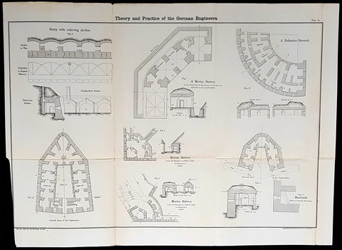
1856 Cap Richard Delafield Large Antique Schematics German Fortifications
- Title : Theory and Practise of the German Engineers
- Condition: (A+) Fine Condition
- Ref: 90194
- Size: 24 1/2in x 18in (615mm x 475mm)
Description:
This large original lithograph print, schematics of parts of the German Forts in such cities as Coblenz, Posen, Mainz, Luxemburg, Landau & others - during the time of the Crimean War - was engraved by John T Bowen & co. of Philadelphia and was published in the 1856 edition of Captain Richard Delafields Report on the Art of War in Europe in 1854, 1855, and 1856.
In early 1855, Captain Richard Delafield was appointed by the Secretary of War, Jefferson Davis, a head of the board of officers, later called The Delafield Commission, and sent to Europe to study the European military. The board included Captain George B. McClellan and Major Alfred Mordecai. They inspected the state of the military in Great Britain, Germany, the Austrian Empire, France, Belgium, and Russia, and served as military observers during the Crimean War. After his return in April 1856, Delafield submitted a report which was later published as a book by Congress, Report on the Art of War in Europe in 1854, 1855, and 1856. The book was suppressed during the American Civil War due to fears that it would be instructive to Confederate engineers as it contained multiple drawings and descriptions of military fortifications.
General Definitions:
Paper thickness and quality: - Light and stable
Paper color : - off white
Age of map color: -
Colors used: -
General color appearance: -
Paper size: - 24 1/2in x 18in (615mm x 475mm)
Plate size: - 24 1/2in x 18in (615mm x 475mm)
Margins: - Min 1/2in (12mm)
Imperfections:
Margins: - None
Plate area: - Folds as issued
Verso: - Folds re-enforced with archival tape
Background:
Under the term of the 1815 Peace of Paris, France was obliged to pay for the construction of a line of fortresses to protect the German Confederation against any future aggression by France. All fortresses were located outside Austria and Prussia — the two biggest, bickering powers of the Confederation.
Section C. Defensive System of the Germanic Confederation of the protocol drawn up at Paris on 3 November 1815, declared Mainz, Luxemburg, and Landau to be fortresses belonging to the Confederation of Germany, and stipulated that a fourth should be constructed on the Upper Rhine. In conformity with this act, a portion of the funds, which France was compelled to pay by way of indemnity for the cost of placing her on a peaceable footing, was thus appropriated: £200,000 were set aside for completing the works at Mainz; £800,000 were assigned to Prussia, to be applied upon its fortresses on the Lower Rhine; another £800,000 were reserved for constructing the new federal fortress on the Upper Rhine; and Bavaria was allowed £600,000 towards erecting another strong place on the Rhine, at Germersheim or some other point.
By 1835 the works about Mainz were completed; the twin fortresses of Koblenz and Ehrenbreitstein, and Cologne had been abundantly strengthened on the side of Prussia; and, on the Bavarian side, the fortress of Germersheim was in a state to defend the passage on the Upper Rhine. The western frontier of Germany had, in this way, been provided with a formidable line of defences against possible hostile actions by their neighbours. The eastern side of Germany has been additionally fortified by the erection of a strong citadel at Posen; and the southern was to be still further protected by the formidable works in course of construction at Brixen in the Tyrol.
The fortress of Ulm became a major strategic fortress able to accommodate 100,000 men and their equipment. Since the Kingdom of Württemberg had no engineering corps King William I appointed Moritz Karl Ernst von Prittwitz, a Prussian major, as the supervisor to oversee the building the fortresses. His plans included the provisions for the prospective development of the city Ulm. Major Theodor von Hildebrandt was appointed to oversee the building of fortresses around Neu-Ulm on the Bavarian side of the Danube.
Delafield, Richard Major General 1798 - 1873
Delafield was a United States Army officer for 52 years. He served as superintendent of the United States Military Academy for 12 years. At the start of the American Civil War, then Colonel Delafield helped equip and send volunteers from New York to the Union Army. He also was in command of defences around New York harbor from 1861 to April 1864. On April 22, 1864, he was promoted to Brigadier General in the Regular Army of the United States and Chief of Engineers. On March 8, 1866, President Andrew Johnson nominated Delafield for appointment to the grade of brevet major general in the Regular Army, to rank from March 13, 1865, and the United States Senate confirmed the appointment on May 4, 1866, reconfirmed due to a technicality on July 14, 1866. He retired from the US Army on August 8, 1866. He later served on two commissions relating to improvements to Boston Harbor and to lighthouses. He also served as a regent of the Smithsonian Institution.
Delafield served as assistant engineer in the construction of Hampton Roads defences from 1819–1824 and was in charge of fortifications and surveys in the Mississippi River delta area in 1824-1832. While superintendent of repair work on the Cumberland Road east of the Ohio River, he designed and built Dunlaps Creek Bridge in Brownsville, Pennsylvania, the first cast-iron tubular-arch bridge in the United States. Commissioned a major of engineers in July 1838, he was appointed superintendent of the Military Academy after the fire of 1838 and served till 1845. He designed the new buildings and the new cadet uniform that first displayed the castle insignia. He superintended the construction of coast defences for New York Harbor from 1846 to 1855.
In the beginning of 1855, Delafield was appointed by the Secretary of War, Jefferson Davis a head of the board of officers, later called The Delafield Commission, and sent to Europe to study the European military. The board included Captain George B. McClellan and Major Alfred Mordecai. They inspected the state of the military in Great Britain, Germany, the Austrian Empire, France, Belgium, and Russia, and served as military observers during the Crimean War. After his return in April 1856, Delafield submitted a report which was later published as a book by Congress, Report on the Art of War in Europe in 1854, 1855, and 1856. The book was suppressed during the American Civil War due to fears that it would be instructive to Confederate engineers as it contained multiple drawings and descriptions of military fortifications.
Delafield served as superintendent of the Military Academy again in 1856-1861. In January 1861, he was succeeded by Captain Pierre G. T. Beauregard, who was dismissed shortly after Beauregards home state of Louisiana seceded from the Union, and Delafield returned as superintendent serving until March 1, 1861. In the beginning of the Civil War he advised the governor of New York Edwin D. Morgan during the volunteer force creation. Then, in 1861–1864, he was put in charge of New York Harbor defences, including Governors Island and Fort at Sandy Hook. On May 19, 1864, he was commissioned a brigadier-general after replacing Joseph Gilbert Totten, who had died, as the Chief of Engineers, United States Army Corps of Engineers, on April 22, 1864. He stayed in charge of the Bureau of Engineers of the War Department until his retirement on August 8, 1866. On March 8, 1866, President Andrew Johnson nominated Delafield for appointment to the grade of brevet major general in the Regular Army of the United States, to rank from March 13, 1865, and the United States Senate confirmed the appointment on May 4, 1866 and reconfirmed it due to a technicality on July 14, 1866.After retirement Delafield served as a regent of the Smithsonian Institution and a member of the Lighthouse Board. He died in Washington, D.C. on November 5, 1873.
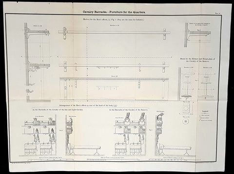
1856 Capt Delafield Large Antique Schematics Internal Calvary Barracks, Quarters
- Title : Cavalry Barracks - Furniture of the Quarters...
- Date : 1856
- Condition: (A+) Fine Condition
- Ref: 90191
- Size: 26in x 20in (660mm x 500mm)
Description:
This large original lithograph print, schematics of the internals of cavalry barracks and quarters - during the time of the Crimean War and just prior to the American Civil War - was engraved by John T Bowen & co. of Philadelphia and was published in the 1856 edition of Captain Richard Delafields Report on the Art of War in Europe in 1854, 1855, and 1856.
In early 1855, Captain Richard Delafield was appointed by the Secretary of War, Jefferson Davis, a head of the board of officers, later called The Delafield Commission, and sent to Europe to study the European military. The board included Captain George B. McClellan and Major Alfred Mordecai. They inspected the state of the military in Great Britain, Germany, the Austrian Empire, France, Belgium, and Russia, and served as military observers during the Crimean War. After his return in April 1856, Delafield submitted a report which was later published as a book by Congress, Report on the Art of War in Europe in 1854, 1855, and 1856. The book was suppressed during the American Civil War due to fears that it would be instructive to Confederate engineers as it contained multiple drawings and descriptions of military fortifications.
General Definitions:
Paper thickness and quality: - Light and stable
Paper color : - off white
Age of map color: -
Colors used: -
General color appearance: -
Paper size: - 26in x 20in (660mm x 500mm)
Plate size: - 26in x 20in (660mm x 500mm)
Margins: - Min 1/2in (12mm)
Imperfections:
Margins: - None
Plate area: - Folds as issued
Verso: - Folds re-enforced with archival tape
Background:
The arrival of explosive shells in the 19th century led to yet another stage in the evolution of fortification. Star forts did not fare well against the effects of high explosive and the intricate arrangements of bastions, flanking batteries and the carefully constructed lines of fire for the defending cannon could be rapidly disrupted by explosive shells.
Worse, the large open ditches surrounding forts of this type were an integral part of the defensive scheme, as was the covered way at the edge of the counter scarp. The ditch was extremely vulnerable to bombardment with explosive shells.
In response, military engineers evolved the polygonal style of fortification. The ditch became deep and vertically sided, cut directly into the native rock or soil, laid out as a series of straight lines creating the central fortified area that gives this style of fortification its name.
Wide enough to be an impassable barrier for attacking troops, but narrow enough to be a difficult target for enemy shellfire, the ditch was swept by fire from defensive blockhouses set in the ditch as well as firing positions cut into the outer face of the ditch itself.
The profile of the fort became very low indeed, surrounded outside the ditch covered by caponiers by a gently sloping open area so as to eliminate possible cover for enemy forces, while the fort itself provided a minimal target for enemy fire. The entrypoint became a sunken gatehouse in the inner face of the ditch, reached by a curving ramp that gave access to the gate via a rolling bridge that could be withdrawn into the gatehouse.
Much of the fort moved underground. Deep passages and tunnels now connected the blockhouses and firing points in the ditch to the fort proper, with magazines and machine rooms deep under the surface. The guns, however, were often mounted in open emplacements and protected only by a parapet; both in order to keep a lower profile and also because experience with guns in closed casemates had seen them put out of action by rubble as their own casemates were collapsed around them.
Gone were citadels surrounding towns: forts were to be moved to the outside of the cities some 12 km to keep the enemy at a distance so their artillery could not bombard the city center. From now on a ring of forts were to be built at a spacing that would allow them to effectively cover the intervals between them.
The new forts abandoned the principle of the bastion, which had also been made obsolete by advances in arms. The outline was a much simplified polygon, surrounded by a ditch. These forts, built in masonry and shaped stone, were designed to shelter their garrison against bombardment. One organizing feature of the new system involved the construction of two defensive curtains: an outer line of forts, backed by an inner ring or line at critical points of terrain or junctions (see, for example, Séré de Rivières system in France).
Traditional fortification however continued to be applied by European armies engaged in warfare in colonies established in Africa against lightly armed attackers from amongst the indigenous population. A relatively small number of defenders in a fort impervious to primitive weaponry could hold out against high odds, the only constraint being the supply of ammunition.
Delafield, Richard Major General 1798 - 1873 - Delafield was a United States Army officer for 52 years. He served as superintendent of the United States Military Academy for 12 years. At the start of the American Civil War, then Colonel Delafield helped equip and send volunteers from New York to the Union Army. He also was in command of defences around New York harbor from 1861 to April 1864. On April 22, 1864, he was promoted to Brigadier General in the Regular Army of the United States and Chief of Engineers. On March 8, 1866, President Andrew Johnson nominated Delafield for appointment to the grade of brevet major general in the Regular Army, to rank from March 13, 1865, and the United States Senate confirmed the appointment on May 4, 1866, reconfirmed due to a technicality on July 14, 1866. He retired from the US Army on August 8, 1866. He later served on two commissions relating to improvements to Boston Harbor and to lighthouses. He also served as a regent of the Smithsonian Institution.
Delafield served as assistant engineer in the construction of Hampton Roads defences from 1819–1824 and was in charge of fortifications and surveys in the Mississippi River delta area in 1824-1832. While superintendent of repair work on the Cumberland Road east of the Ohio River, he designed and built Dunlaps Creek Bridge in Brownsville, Pennsylvania, the first cast-iron tubular-arch bridge in the United States. Commissioned a major of engineers in July 1838, he was appointed superintendent of the Military Academy after the fire of 1838 and served till 1845. He designed the new buildings and the new cadet uniform that first displayed the castle insignia. He superintended the construction of coast defences for New York Harbor from 1846 to 1855.
In the beginning of 1855, Delafield was appointed by the Secretary of War, Jefferson Davis a head of the board of officers, later called The Delafield Commission, and sent to Europe to study the European military. The board included Captain George B. McClellan and Major Alfred Mordecai. They inspected the state of the military in Great Britain, Germany, the Austrian Empire, France, Belgium, and Russia, and served as military observers during the Crimean War. After his return in April 1856, Delafield submitted a report which was later published as a book by Congress, Report on the Art of War in Europe in 1854, 1855, and 1856. The book was suppressed during the American Civil War due to fears that it would be instructive to Confederate engineers as it contained multiple drawings and descriptions of military fortifications.
Delafield served as superintendent of the Military Academy again in 1856-1861. In January 1861, he was succeeded by Captain Pierre G. T. Beauregard, who was dismissed shortly after Beauregards home state of Louisiana seceded from the Union, and Delafield returned as superintendent serving until March 1, 1861. In the beginning of the Civil War he advised the governor of New York Edwin D. Morgan during the volunteer force creation. Then, in 1861–1864, he was put in charge of New York Harbor defences, including Governors Island and Fort at Sandy Hook. On May 19, 1864, he was commissioned a brigadier-general after replacing Joseph Gilbert Totten, who had died, as the Chief of Engineers, United States Army Corps of Engineers, on April 22, 1864. He stayed in charge of the Bureau of Engineers of the War Department until his retirement on August 8, 1866. On March 8, 1866, President Andrew Johnson nominated Delafield for appointment to the grade of brevet major general in the Regular Army of the United States, to rank from March 13, 1865, and the United States Senate confirmed the appointment on May 4, 1866 and reconfirmed it due to a technicality on July 14, 1866.After retirement Delafield served as a regent of the Smithsonian Institution and a member of the Lighthouse Board. He died in Washington, D.C. on November 5, 1873.
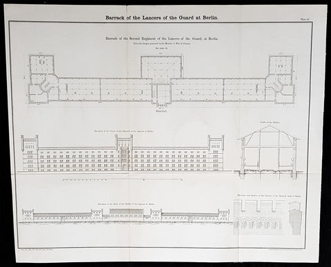
1856 Capt Delafield Large Antique Schematics of the 2nd Lancers Barracks, Berlin
- Title : Barrack of the Lancers of the Guard at Berlin...Barrack of the Second Regiment of the Lancers of the Guard at Berlin
- Date : 1856
- Condition: (A+) Fine Condition
- Ref: 90152
- Size: 21in x 17in (530mm x 430mm)
Description:
This large original lithograph print, schematics of the 2nd German Lancer Regiment Barracks in Berlin - during the time of the Crimean War and just prior to the American Civil War - was engraved by John T Bowen & co. of Philadelphia and was published in the 1856 edition of Captain Richard Delafields Report on the Art of War in Europe in 1854, 1855, and 1856.
In early 1855, Captain Richard Delafield was appointed by the Secretary of War, Jefferson Davis, a head of the board of officers, later called The Delafield Commission, and sent to Europe to study the European military. The board included Captain George B. McClellan and Major Alfred Mordecai. They inspected the state of the military in Great Britain, Germany, the Austrian Empire, France, Belgium, and Russia, and served as military observers during the Crimean War. After his return in April 1856, Delafield submitted a report which was later published as a book by Congress, Report on the Art of War in Europe in 1854, 1855, and 1856. The book was suppressed during the American Civil War due to fears that it would be instructive to Confederate engineers as it contained multiple drawings and descriptions of military fortifications.
General Definitions:
Paper thickness and quality: - Light and stable
Paper color : - off white
Age of map color: -
Colors used: -
General color appearance: -
Paper size: - 21in x 17in (530mm x 430mm)
Plate size: - 21in x 17in (530mm x 430mm)
Margins: - Min 1/2in (12mm)
Imperfections:
Margins: - None
Plate area: - Folds as issued
Verso: - Folds re-enforced with archival tape
Background:
A lancer was a type of cavalryman who fought with a lance. Lances were used in mounted warfare by the Assyrians as early as 700 BC and subsequently by Greek, Persian, Gallic, Chinese, and Roman horsemen. The weapon was widely used in Asia and Europe during the Middle Ages and the Renaissance by armoured cavalry, before being adopted by light cavalry, particularly in Eastern Europe. In a modern context, a lancer regiment usually denotes an armoured unit.
The lancer (called ułan in Polish and Uhlan in German) had become a common sight in almost every European, Ottoman, and Indian army during this time, but, with the exception of the Ottoman troops, they increasingly discarded the heavy armour to give greater freedom of movement in combat. The Polish winged lancers were amongst the last to abandon the armour in Europe. There was debate over the value of the lance in mounted combat during the 18th century and most armies had few lancer units by the beginning of the 19th century. However, during the Napoleonic Wars, lancers were to be seen in many of the combatant nations as their value in shock tactics became clear. During the wars, the Poles became a ready source of recruitment for several armies, willingly or unwillingly. Polish lancers served with distinction in the Austrian, Prussian, Russian and French armies, most famously in Napoleons French Imperial Guard as the 1er Regiment de Chevau-Legers-Lanciers de la Garde Impériale.
At the Battle of Waterloo, French lances were nearly three meters (about nine feet, ten inches) long, weighed three kilograms (about six pounds, ten ounces), and had a steel point on a wooden staff, according to historian Alessandro Barbero. He adds that they were terrifyingly efficient. Commander of the French 1st Corps, 4th Division General Durutte, who saw the battle from the high ground in front of Papelotte, would write later, I had never before realized the great superiority of the lance over the sword.
In the Siege of Los Angeles (1846), during the war between Mexico and the United States, a company of Californio lancers temporarily recaptured the town, expelling a company of U.S. Marines.
Although having substantial impact in the charge, lancers could be vulnerable to other cavalry at close quarters, where the lance proved a clumsy and easily deflected weapon when employed against sabres. By the late 19th century, many cavalry regiments in the British and other European armies were composed of troopers with lances, as primary weapons, in the front rank and horsemen with sabres only in the second: the lances for the initial shock and sabres for the subsequent mêlée.
Delafield, Richard Major General 1798 - 1873
Delafield was a United States Army officer for 52 years. He served as superintendent of the United States Military Academy for 12 years. At the start of the American Civil War, then Colonel Delafield helped equip and send volunteers from New York to the Union Army. He also was in command of defences around New York harbor from 1861 to April 1864. On April 22, 1864, he was promoted to Brigadier General in the Regular Army of the United States and Chief of Engineers. On March 8, 1866, President Andrew Johnson nominated Delafield for appointment to the grade of brevet major general in the Regular Army, to rank from March 13, 1865, and the United States Senate confirmed the appointment on May 4, 1866, reconfirmed due to a technicality on July 14, 1866. He retired from the US Army on August 8, 1866. He later served on two commissions relating to improvements to Boston Harbor and to lighthouses. He also served as a regent of the Smithsonian Institution.
Delafield served as assistant engineer in the construction of Hampton Roads defences from 1819–1824 and was in charge of fortifications and surveys in the Mississippi River delta area in 1824-1832. While superintendent of repair work on the Cumberland Road east of the Ohio River, he designed and built Dunlaps Creek Bridge in Brownsville, Pennsylvania, the first cast-iron tubular-arch bridge in the United States. Commissioned a major of engineers in July 1838, he was appointed superintendent of the Military Academy after the fire of 1838 and served till 1845. He designed the new buildings and the new cadet uniform that first displayed the castle insignia. He superintended the construction of coast defences for New York Harbor from 1846 to 1855.
In the beginning of 1855, Delafield was appointed by the Secretary of War, Jefferson Davis a head of the board of officers, later called The Delafield Commission, and sent to Europe to study the European military. The board included Captain George B. McClellan and Major Alfred Mordecai. They inspected the state of the military in Great Britain, Germany, the Austrian Empire, France, Belgium, and Russia, and served as military observers during the Crimean War. After his return in April 1856, Delafield submitted a report which was later published as a book by Congress, Report on the Art of War in Europe in 1854, 1855, and 1856. The book was suppressed during the American Civil War due to fears that it would be instructive to Confederate engineers as it contained multiple drawings and descriptions of military fortifications.
Delafield served as superintendent of the Military Academy again in 1856-1861. In January 1861, he was succeeded by Captain Pierre G. T. Beauregard, who was dismissed shortly after Beauregards home state of Louisiana seceded from the Union, and Delafield returned as superintendent serving until March 1, 1861. In the beginning of the Civil War he advised the governor of New York Edwin D. Morgan during the volunteer force creation. Then, in 1861–1864, he was put in charge of New York Harbor defences, including Governors Island and Fort at Sandy Hook. On May 19, 1864, he was commissioned a brigadier-general after replacing Joseph Gilbert Totten, who had died, as the Chief of Engineers, United States Army Corps of Engineers, on April 22, 1864. He stayed in charge of the Bureau of Engineers of the War Department until his retirement on August 8, 1866. On March 8, 1866, President Andrew Johnson nominated Delafield for appointment to the grade of brevet major general in the Regular Army of the United States, to rank from March 13, 1865, and the United States Senate confirmed the appointment on May 4, 1866 and reconfirmed it due to a technicality on July 14, 1866.After retirement Delafield served as a regent of the Smithsonian Institution and a member of the Lighthouse Board. He died in Washington, D.C. on November 5, 1873.
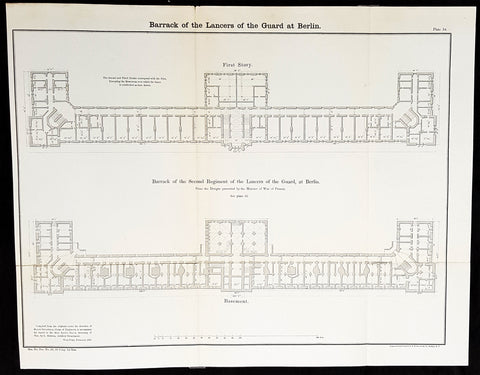
1856 Capt Delafield Large Antique Schematics of the 2nd Lancers Barracks, Berlin
- Title : Barrack of the Lancers of the Guard at Berlin...Barrack of the Second Regiment of the Lancers of the Guard at Berlin
- Date : 1856
- Condition: (A+) Fine Condition
- Ref: 90143
- Size: 20 1/2in x 16in (510mm x 410mm)
Description:
This large original lithograph print, schematics of the 2nd German Lancer Regiment Barracks in Berlin - during the time of the Crimean War and just prior to the American Civil War - was engraved by John T Bowen & co. of Philadelphia and was published in the 1856 edition of Captain Richard Delafields Report on the Art of War in Europe in 1854, 1855, and 1856.
In early 1855, Captain Richard Delafield was appointed by the Secretary of War, Jefferson Davis, a head of the board of officers, later called The Delafield Commission, and sent to Europe to study the European military. The board included Captain George B. McClellan and Major Alfred Mordecai. They inspected the state of the military in Great Britain, Germany, the Austrian Empire, France, Belgium, and Russia, and served as military observers during the Crimean War. After his return in April 1856, Delafield submitted a report which was later published as a book by Congress, Report on the Art of War in Europe in 1854, 1855, and 1856. The book was suppressed during the American Civil War due to fears that it would be instructive to Confederate engineers as it contained multiple drawings and descriptions of military fortifications.
General Definitions:
Paper thickness and quality: - Light and stable
Paper color : - off white
Age of map color: -
Colors used: -
General color appearance: -
Paper size: - 20 1/2in x 16in (510mm x 410mm)
Plate size: - 20 1/2in x 16in (510mm x 410mm)
Margins: - Min 1/2in (12mm)
Imperfections:
Margins: - None
Plate area: - Folds as issued
Verso: - Folds re-enforced with archival tape
Background:
A lancer was a type of cavalryman who fought with a lance. Lances were used in mounted warfare by the Assyrians as early as 700 BC and subsequently by Greek, Persian, Gallic, Chinese, and Roman horsemen. The weapon was widely used in Asia and Europe during the Middle Ages and the Renaissance by armoured cavalry, before being adopted by light cavalry, particularly in Eastern Europe. In a modern context, a lancer regiment usually denotes an armoured unit.
The lancer (called ułan in Polish and Uhlan in German) had become a common sight in almost every European, Ottoman, and Indian army during this time, but, with the exception of the Ottoman troops, they increasingly discarded the heavy armour to give greater freedom of movement in combat. The Polish winged lancers were amongst the last to abandon the armour in Europe. There was debate over the value of the lance in mounted combat during the 18th century and most armies had few lancer units by the beginning of the 19th century. However, during the Napoleonic Wars, lancers were to be seen in many of the combatant nations as their value in shock tactics became clear. During the wars, the Poles became a ready source of recruitment for several armies, willingly or unwillingly. Polish lancers served with distinction in the Austrian, Prussian, Russian and French armies, most famously in Napoleons French Imperial Guard as the 1er Regiment de Chevau-Legers-Lanciers de la Garde Impériale.
At the Battle of Waterloo, French lances were nearly three meters (about nine feet, ten inches) long, weighed three kilograms (about six pounds, ten ounces), and had a steel point on a wooden staff, according to historian Alessandro Barbero. He adds that they were terrifyingly efficient. Commander of the French 1st Corps, 4th Division General Durutte, who saw the battle from the high ground in front of Papelotte, would write later, I had never before realized the great superiority of the lance over the sword.
In the Siege of Los Angeles (1846), during the war between Mexico and the United States, a company of Californio lancers temporarily recaptured the town, expelling a company of U.S. Marines.
Although having substantial impact in the charge, lancers could be vulnerable to other cavalry at close quarters, where the lance proved a clumsy and easily deflected weapon when employed against sabres. By the late 19th century, many cavalry regiments in the British and other European armies were composed of troopers with lances, as primary weapons, in the front rank and horsemen with sabres only in the second: the lances for the initial shock and sabres for the subsequent mêlée.
Delafield, Richard Major General 1798 - 1873
Delafield was a United States Army officer for 52 years. He served as superintendent of the United States Military Academy for 12 years. At the start of the American Civil War, then Colonel Delafield helped equip and send volunteers from New York to the Union Army. He also was in command of defences around New York harbor from 1861 to April 1864. On April 22, 1864, he was promoted to Brigadier General in the Regular Army of the United States and Chief of Engineers. On March 8, 1866, President Andrew Johnson nominated Delafield for appointment to the grade of brevet major general in the Regular Army, to rank from March 13, 1865, and the United States Senate confirmed the appointment on May 4, 1866, reconfirmed due to a technicality on July 14, 1866. He retired from the US Army on August 8, 1866. He later served on two commissions relating to improvements to Boston Harbor and to lighthouses. He also served as a regent of the Smithsonian Institution.
Delafield served as assistant engineer in the construction of Hampton Roads defences from 1819–1824 and was in charge of fortifications and surveys in the Mississippi River delta area in 1824-1832. While superintendent of repair work on the Cumberland Road east of the Ohio River, he designed and built Dunlaps Creek Bridge in Brownsville, Pennsylvania, the first cast-iron tubular-arch bridge in the United States. Commissioned a major of engineers in July 1838, he was appointed superintendent of the Military Academy after the fire of 1838 and served till 1845. He designed the new buildings and the new cadet uniform that first displayed the castle insignia. He superintended the construction of coast defences for New York Harbor from 1846 to 1855.
In the beginning of 1855, Delafield was appointed by the Secretary of War, Jefferson Davis a head of the board of officers, later called The Delafield Commission, and sent to Europe to study the European military. The board included Captain George B. McClellan and Major Alfred Mordecai. They inspected the state of the military in Great Britain, Germany, the Austrian Empire, France, Belgium, and Russia, and served as military observers during the Crimean War. After his return in April 1856, Delafield submitted a report which was later published as a book by Congress, Report on the Art of War in Europe in 1854, 1855, and 1856. The book was suppressed during the American Civil War due to fears that it would be instructive to Confederate engineers as it contained multiple drawings and descriptions of military fortifications.
Delafield served as superintendent of the Military Academy again in 1856-1861. In January 1861, he was succeeded by Captain Pierre G. T. Beauregard, who was dismissed shortly after Beauregards home state of Louisiana seceded from the Union, and Delafield returned as superintendent serving until March 1, 1861. In the beginning of the Civil War he advised the governor of New York Edwin D. Morgan during the volunteer force creation. Then, in 1861–1864, he was put in charge of New York Harbor defences, including Governors Island and Fort at Sandy Hook. On May 19, 1864, he was commissioned a brigadier-general after replacing Joseph Gilbert Totten, who had died, as the Chief of Engineers, United States Army Corps of Engineers, on April 22, 1864. He stayed in charge of the Bureau of Engineers of the War Department until his retirement on August 8, 1866. On March 8, 1866, President Andrew Johnson nominated Delafield for appointment to the grade of brevet major general in the Regular Army of the United States, to rank from March 13, 1865, and the United States Senate confirmed the appointment on May 4, 1866 and reconfirmed it due to a technicality on July 14, 1866.After retirement Delafield served as a regent of the Smithsonian Institution and a member of the Lighthouse Board. He died in Washington, D.C. on November 5, 1873.
1856 Cpt R Delafield Large Antique Schematics 2nd Lancer Barracks Stables Berlin
- Title : Barrack and stables of the Lancers of the Guard at Berlin...Barrack of the Second Regiment of the Lancers of teh Guard at Berlin
- Date : 1856
- Condition: (A) Very Good Condition
- Ref: 90142
- Size: 18 1/2in x 16in (470mm x 405mm)
Description:
This large original lithograph print, schematics of the 2nd German Lancer Regiment Barracks & Stables in Berlin - during the time of the Crimean War and just prior to the American Civil War - was engraved by John T Bowen & co. of Philadelphia and was published in the 1856 edition of Captain Richard Delafields Report on the Art of War in Europe in 1854, 1855, and 1856.
In early 1855, Captain Richard Delafield was appointed by the Secretary of War, Jefferson Davis, a head of the board of officers, later called The Delafield Commission, and sent to Europe to study the European military. The board included Captain George B. McClellan and Major Alfred Mordecai. They inspected the state of the military in Great Britain, Germany, the Austrian Empire, France, Belgium, and Russia, and served as military observers during the Crimean War. After his return in April 1856, Delafield submitted a report which was later published as a book by Congress, Report on the Art of War in Europe in 1854, 1855, and 1856. The book was suppressed during the American Civil War due to fears that it would be instructive to Confederate engineers as it contained multiple drawings and descriptions of military fortifications.
General Definitions:
Paper thickness and quality: - Light and stable
Paper color : - off white
Age of map color: -
Colors used: -
General color appearance: -
Paper size: - 18 1/2in x 16in (470mm x 405mm)
Plate size: - 18 1/2in x 16in (470mm x 405mm)
Margins: - Min 1/2in (12mm)
Imperfections:
Margins: - None
Plate area: - Folds as issued
Verso: - Folds re-enforced with archival tape
Background:
A lancer was a type of cavalryman who fought with a lance. Lances were used in mounted warfare by the Assyrians as early as 700 BC and subsequently by Greek, Persian, Gallic, Chinese, and Roman horsemen. The weapon was widely used in Asia and Europe during the Middle Ages and the Renaissance by armoured cavalry, before being adopted by light cavalry, particularly in Eastern Europe. In a modern context, a lancer regiment usually denotes an armoured unit.
The lancer (called ułan in Polish and Uhlan in German) had become a common sight in almost every European, Ottoman, and Indian army during this time, but, with the exception of the Ottoman troops, they increasingly discarded the heavy armour to give greater freedom of movement in combat. The Polish winged lancers were amongst the last to abandon the armour in Europe. There was debate over the value of the lance in mounted combat during the 18th century and most armies had few lancer units by the beginning of the 19th century. However, during the Napoleonic Wars, lancers were to be seen in many of the combatant nations as their value in shock tactics became clear. During the wars, the Poles became a ready source of recruitment for several armies, willingly or unwillingly. Polish lancers served with distinction in the Austrian, Prussian, Russian and French armies, most famously in Napoleons French Imperial Guard as the 1er Regiment de Chevau-Legers-Lanciers de la Garde Impériale.
At the Battle of Waterloo, French lances were nearly three meters (about nine feet, ten inches) long, weighed three kilograms (about six pounds, ten ounces), and had a steel point on a wooden staff, according to historian Alessandro Barbero. He adds that they were terrifyingly efficient. Commander of the French 1st Corps, 4th Division General Durutte, who saw the battle from the high ground in front of Papelotte, would write later, I had never before realized the great superiority of the lance over the sword.
In the Siege of Los Angeles (1846), during the war between Mexico and the United States, a company of Californio lancers temporarily recaptured the town, expelling a company of U.S. Marines.
Although having substantial impact in the charge, lancers could be vulnerable to other cavalry at close quarters, where the lance proved a clumsy and easily deflected weapon when employed against sabres. By the late 19th century, many cavalry regiments in the British and other European armies were composed of troopers with lances, as primary weapons, in the front rank and horsemen with sabres only in the second: the lances for the initial shock and sabres for the subsequent mêlée.
Delafield, Richard Major General 1798 - 1873 - Delafield was a United States Army officer for 52 years. He served as superintendent of the United States Military Academy for 12 years. At the start of the American Civil War, then Colonel Delafield helped equip and send volunteers from New York to the Union Army. He also was in command of defences around New York harbor from 1861 to April 1864. On April 22, 1864, he was promoted to Brigadier General in the Regular Army of the United States and Chief of Engineers. On March 8, 1866, President Andrew Johnson nominated Delafield for appointment to the grade of brevet major general in the Regular Army, to rank from March 13, 1865, and the United States Senate confirmed the appointment on May 4, 1866, reconfirmed due to a technicality on July 14, 1866. He retired from the US Army on August 8, 1866. He later served on two commissions relating to improvements to Boston Harbor and to lighthouses. He also served as a regent of the Smithsonian Institution.
Delafield served as assistant engineer in the construction of Hampton Roads defences from 1819–1824 and was in charge of fortifications and surveys in the Mississippi River delta area in 1824-1832. While superintendent of repair work on the Cumberland Road east of the Ohio River, he designed and built Dunlaps Creek Bridge in Brownsville, Pennsylvania, the first cast-iron tubular-arch bridge in the United States. Commissioned a major of engineers in July 1838, he was appointed superintendent of the Military Academy after the fire of 1838 and served till 1845. He designed the new buildings and the new cadet uniform that first displayed the castle insignia. He superintended the construction of coast defences for New York Harbor from 1846 to 1855.
In the beginning of 1855, Delafield was appointed by the Secretary of War, Jefferson Davis a head of the board of officers, later called The Delafield Commission, and sent to Europe to study the European military. The board included Captain George B. McClellan and Major Alfred Mordecai. They inspected the state of the military in Great Britain, Germany, the Austrian Empire, France, Belgium, and Russia, and served as military observers during the Crimean War. After his return in April 1856, Delafield submitted a report which was later published as a book by Congress, Report on the Art of War in Europe in 1854, 1855, and 1856. The book was suppressed during the American Civil War due to fears that it would be instructive to Confederate engineers as it contained multiple drawings and descriptions of military fortifications.
Delafield served as superintendent of the Military Academy again in 1856-1861. In January 1861, he was succeeded by Captain Pierre G. T. Beauregard, who was dismissed shortly after Beauregards home state of Louisiana seceded from the Union, and Delafield returned as superintendent serving until March 1, 1861. In the beginning of the Civil War he advised the governor of New York Edwin D. Morgan during the volunteer force creation. Then, in 1861–1864, he was put in charge of New York Harbor defences, including Governors Island and Fort at Sandy Hook. On May 19, 1864, he was commissioned a brigadier-general after replacing Joseph Gilbert Totten, who had died, as the Chief of Engineers, United States Army Corps of Engineers, on April 22, 1864. He stayed in charge of the Bureau of Engineers of the War Department until his retirement on August 8, 1866. On March 8, 1866, President Andrew Johnson nominated Delafield for appointment to the grade of brevet major general in the Regular Army of the United States, to rank from March 13, 1865, and the United States Senate confirmed the appointment on May 4, 1866 and reconfirmed it due to a technicality on July 14, 1866.After retirement Delafield served as a regent of the Smithsonian Institution and a member of the Lighthouse Board. He died in Washington, D.C. on November 5, 1873.