

Willem Blaeu (1571 - 1638) Joan Blaeu 1596-1673
Profile :
At the beginning of the seventeenth century Amsterdam was becoming one of the wealthiest trading cities in Europe, the base of the Dutch East India Company and a center of banking and the diamond trade, its people noted for their intellectual skills and splendid craftsmanship.
At this propitious time in the history of the Northern Provinces, Willem Janszoon Blaeu, who was born at Alkmaar in 1571 and trained in astronomy and the sciences by Tycho Brahe, the celebrated Danish astronomer, founded a business in Amsterdam in 1599 as a globe and instrument maker. It was not long before the business expanded, publishing maps, topographical works and books of sea charts as well as constructing globes. His most notable early work was a map of Holland (1604), a fine World Map (1605-06) and Het Licht der Zeevaerdt (The Light of Navigation), a marine atlas, which went through many editions in different languages and under a variety of titles. At the same time Blaeu was planning a major atlas intended to include the most up-to-date maps of the whole of the known world but progress on so vast a project was slow and not until he bought between 30 and 40 plates of the Mercator Atlas from Jodocus Hondius II to add to his own collection was he able to publish, in 1630, a 60-map volume with the title Atlantis Appendix. It was another five years before the first two volumes of his planned world atlas, Atlas Novus or the Theatrum Orbis Terrarum were issued. About this time he was appointed Hydrographer to the East India Company.
In 1638 Blaeu died and the business passed into the hands of his sons, Joan and Cornelis, who continued and expanded their father's ambitious plans. After the death of Cornelis, Joan directed the work alone and the whole series of 6 volumes was eventually completed about 1655. As soon as it was finished he began the preparation of the even larger work, the Atlas Major, which reached publication in 1662 in II volumes (later editions in 9-12 volumes) and contained nearly 6oo double-page maps and 3,000 pages of text. This was, and indeed remains, the most magnificent work of its kind ever produced; perhaps its geographical content was not as up-to-date or as accurate as its author could have wished, but any deficiencies in that direction were more than compensated for by the fine engraving and colouring, the elaborate cartouches and pictorial and heraldic detail and especially the splendid calligraphy.
In 1672 a disastrous fire destroyed Blaeu's printing house in the Gravenstraat and a year afterwards Joan Blaeu died. The firm's surviving stocks of plates and maps were gradually dispersed, some of the plates being bought by F. de Wit and Schenk and Valck, before final closure in about 1695.
It ought to be mentioned here that there is often confusion between the elder Blaeu and his rival Jan J ansson (Johannes Janssonius). Up to about 1619 Blaeu often signed his works Guilielmus Janssonius or Willems Jans Zoon but after that time he seems to have decided on Guilielmus or G. Blaeu.
Willem & Joan Blaeu (3)

1638 Joan Blaeu Antique Map of America - Americae nova Tabula
- Title : Americae nova Tabula Auct: Guiljesino Blaeuw
- Date : 1638
- Condition: (A) Very Good Condition
- Ref # : 50685
- Size : 23in x 18 1/2in (585mm x 450mm)
Description:
This magnificent, classic hand coloured original antique map of America 2nd State - the quintessential image of 17th America - was published in the 1638 French edition of Joan Blaeus Atlas Novus. This map is in wonderful condition with a few minor repairs as mentioned below.
General Condition:
Paper thickness and quality: - Heavy and stable
Paper color: - White
Age of map color: - Original color
Colors used: - Pink, green, yellow, blue, red
General color appearance: - Authentic & beautiful
Paper size: - 23in x 18 1/2in (585mm x 450mm)
Plate size: - 22in x 16 1/2in (555mm x 415mm)
Margins: - Min 1in (25mm)
Imperfections:
Margins: - Professional repair to centerfold, no loss.
Plate area: - Small professional repair to below Atlantic monster. Center-fold creases & re-joined at bottom, slight separation
Verso: - Creasing and restoration to center-fold, top & left margin, no loss
Background:
Originally issued by Joan Blaeus father, Willem, as early as 1617, this general map of the Americas was one of the longest lived plates in the atlas, having been used as an atlas map since 1630.
Here is the general seventeenth century European view of the Western Hemisphere: the delineation of the coasts and the nomenclature of the Pacific as well as the Atlantic coasts are basically Spanish in origin and follow the maps of the Fleming Abraham Ortelius and his countryman Cornelis Wytfliet. To these, Willem Blaeu inserted, on the east coast, the English names given by the Roanoke colonists in Virginia, and by Martin Frobisher, John Davis and Henry Hudson in the far north. In Florida and along the St Lawrence, Blaeu added the names given by the French settlers, almost the only memorials to their ill-fated venture in Florida during the latter part of the sixteenth century.
When Blaeu first made his map in the early years of the seventeenth century, Europeans still had no real knowledge of the nature of the Mississippi system. From the expedition journals of Hernando de Soto (1539 - 1543) they had inferred an extensive range of mountains trending eastwards to the north of the Gulf of Mexico in la Florida apparently precluding a great river system. The Great Lakes were as yet unknown although by the time Blaeu issued this map in its atlas form in the Huron region together with the hearsay accounts from Coral Indians were becoming well known through his 1632 map of the region. Evidently, this appears to have been unknown to Blaeu at the time, but surprisingly, he never incorporated the information on later printings of the map. The same applies to Manhattan and Long Island as well, despite the fact that only a short distance from Amsterdam, the Leiden academic Johannes D Late had published the first edition of his monumental work on the Americas which provided source material for any number of maps of the Americas throughout the remainder of the century and beyond.
In common with the other general continental maps in Blaeus atlas's, he has provided perspective plans or views of settlements in the Americas, including Havana, St Domingo, Cartagena, Mexico, Cusco, Potisi, I.la Moca in Chile, Rio Janeiro and Olianda in Pharnambucco, as well as the vignette illustrations of native figures taken from the accounts of John White (Virginia) or Hans Staden (Brazil) and others. (Ref: Burden; RGS; Koeman; Tooley)
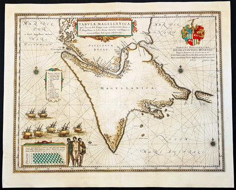
1642 Joan Blaeu Large Antique Map of Tierra Del Fuego & the Magellan Straits, South America
- Title : Tabula Magellanica qua Tierrae del Fuego
- Size: 23in x 19in (585mm x 485mm)
- Condition: (A+) Fine Condition
- Date : 1642
- Ref #: 93352
Description:
This original beautifully hand coloured copper-plate engraved antique map of the Tierra Del Fuego & the Magellan Straits at the very bottom of South America, was published in the 1642 Dutch edition of Joan Blaeus Atlas Nouvs.
General Definitions:
Paper thickness and quality: - Heavy and stable
Paper color : - off white
Age of map color: - Original
Colors used: - Yellow, green, blue, pink
General color appearance: - Authentic
Paper size: - 23in x 19in (585mm x 485mm)
Plate size: - 21in x 16 1/2in (535mm x 420mm)
Margins: - Min 1in (25mm)
Imperfections:
Margins: - Age toning
Plate area: - Age toning
Verso: - Age toning
Background:
Ferdinand Magellan became the first European to navigate the strait in 1520, during his global circumnavigation voyage. Because Magellan\'s ships entered it on November 1, All Saints\' Day, it was originally named Estrecho de Todos los Santos (Strait of All Saints). Later the Spanish king changed the name to Estrecho de Magallanes in honor of Magellan. Since its discovery the Spanish Empire and the Kingdom of Chile saw it as its southern boundary. The first Spanish colonization attempt was led by Pedro Sarmiento de Gamboa who founded Nombre de Jesús and Rey Don Felipe on its northern shores. The cities suffered severe food shortages, and years afterwards in 1587 the English navigator Sir Thomas Cavendish landed at the site of Rey Don Felipe and found only ruins of the settlement. He renamed the place Port Famine. Other early explorers included Francis Drake among others.
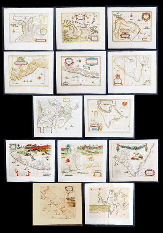
1662 Blaeu & Barlaeus Complete Set of 13 x Antique Maps of South America
Antique Map
- Titles:
1. Terra Firma
2. Venezuela
3. Guiana
4. Peru
5. Chili
6. Brasilia
7. Paraquaria
8. Tabula Magellanica
9. Preafecturae Paranambucae Prs Borealis
10. Praefecturae De Paraiba et Rio Grande
11. Praefectura De Ciriii vel Seregippe
12. Praefectura Paranambucae Pars Meridionalis
13. Sinus Omnium Sanctoru - Sizes: 24in x 20 1/2in (610mm x 520mm)ea
- Condition: (A) Very Good to Fine Condition
- Date: 1662
- Ref #: BlaeuSA 1662
Description:
This is a unique opportunity to acquire a complete set of the 13 maps of South America, including the 4 rare uniform Blaeu-Barleus maps of the Coast of Brazil, published by Joan Blaeu in his monumental & rare 1st 1662 Atlas, Latin edition of Atlas Major.
All paper in imprinted with a large Elephant watermark donating german paper from the 1660s.
The maps cover the full geographical area from North to South, South America from Panama to Tierra Firma. Please see the background section below for details of each map. All maps have wide original margins & colour on strong sturdy paper.
Joan Blaeus 11 volumes of Atlas Major, is considered by many to be the greatest atlas set ever published. It excels in comprehensiveness, engraving, color, and overall production. The first edition was published in Latin in 1662 and was subsequently published in French, Dutch, German, and Spanish over the next 10 years.
On the 23rd of February 1672, a fire broke out in central Amsterdam, that ended the reign of one of the greatest & most prolific publishers of printed maps and atlases in publishing history. The Blaeu family had reached its zenith 10 years previously, with the publication of its greatest achievement, the Atlas Major or Great Atlas, consisting of 11 volumes, with geographical detail reflecting many of the achievements of the Golden Age of the United Netherlands. Blaeus Atlas Major were the most expensive books printed in the 17th century.
General Definitions:
Paper thickness and quality: - Heavy and stable
Paper color : - off white
Age of map color: - Original
Colors used: - Blue, pink, red, green, yellow
General color appearance: - Authentic
Paper size: - 24in x 20 1/2in (610mm x 520mm)
Plate size: - Various, pls see below
Margins: - Min 1in (25mm) min
Imperfections:
Margins: - Pls see below
Plate area: - Pls see below
Verso: - Pls see below
Background:
1. Terra Firma - This regional map of the north eastern corner of South America belongs to the early group of plates printed by Willem Blaeu from 1630 onwards. It covers modern Colombia, part of Venezuela and Panama.
Plate: 19in x 14 1/2in.
Condition: Very light age toning
2. Venezuela - This map showing the area of modern Venezuela to the north of the Orinoco valley is another of the early plates of the 1630s. It extends from Lago dee Maracaibo in the west to the Island of Trinidad in the east and also shows the Dutch held Islands of Curacao, Aruba and Bonaire which served as a base of the Geotroyeerde West Indische Compaagnie (or Netherlands West Indian Company) since 1634.
Plate: 18 3/4in x 14 1/2in
Condition: Age toning, printers crease along centerfold, 8 small worm holes.
3. Guiana - This handsome map, another of the Blaeu maps of 1630, extendends from the Isla Margarita in the north-west to the coast of Northern Brazil near Sao Luis east of the Amazonas delta. The interior is dominated by a large island sea , the Parime Lacus, on whose north wesstern shores lies the fabled city of Manoa, de el Dorado, golden City of the Inca.
Plate: 19 1/4in x 14 1/2in
Condition: Light age toning
4. Peru - Here willem Blaeu, this map being part of Pacific Coast of South America from Ecuador (at the left hand side) as far south as the Atacama desert in the northern reaches of Chile.
Plate: 19 1/4in x 14 3/4in
Condition: Light age toning
5. Chili - This is another of Willem Blaeus early group f maps showing the coastal region of Central Chile from Copiapo in the north as far as a point to the south of the island of Chiloe.
Plate: 16 3/4in x 14in
Condition: Light age toning
6. Brasilia - Oriented west to the top of the plate, this general map of Brazil was an early product of Joan Blaeu himself, made after he had assumed full control of the publishing house following the death of his father a few years earlier.
This plate was made to replace the De Laet derivative which Willem had acquired from the Hondius plate stock in 1629 and is considerably more detailed than its earlier name sake.
Plate: 19 1/2in x 15 1/4in
Condition: Light age toning
7. Paraquaria - First map of Paraguay published first in this 1662 Atlas Major and so rare only published for 10 years or so.
Plate: 21 1/2in x 19 1/2in
Condition: Light age toning
8. Tabula Magellanica - Beautifully engraved map of the Magellan Straits first published in 1635
Plate: 19in x 16 1/2in
Condition: Light age toning
9. Preafecturae Paranambucae Prs Borealis
10. Praefecturae De Paraiba et Rio Grande
11. Praefectura De Ciriii vel Seregippe
12. Praefectura Paranambucae Pars Meridionalis
These 4 beautiful uniform maps are quite unlike any other maps found in Blaeu's Atlas Major.
Although they first appeared in the atlas for in 1662, these 4 maps first appeared in another earlier work published by Blaeu, the Rerum per octennium in Brasilia (1647) by the Remonstrant theologian Casper van Baerle (or Barlaeus) who died very soon afterwards in 1648.
Barlaeus great work, still one of the most valuable sources for Brazilian history, was published under the auspices of the Dutch governor in Brazil, Johan Maurits of Nassau Siegen, whose governorship from 1637 to 1644 Barlaeus describes in a eulogistic but nevertheless impartial account compiled from official sources.
The large pictorial vignettes of this group of maps illustrate much about local life and conditions of the time: in Preafecturae Paranambucae Prs Borealis & Praefecturae De Paraiba et Rio Grandea is shown processions of Indians from a mission, illustrated after paintings of the artist Frans Janszoon Post (1612 - 1680) who was with Johan Maurits in Brazil during the years 1637 - 1644. The buildings depicted have not been identified with any certainty but must have been in or near Pernambuco
Plates:
(9) 21in x 16 1/2in
(10) 21in x 16 1/2in
(11) 21in x 16 1/2in
(12) 17 1/2in x 16 1/2in
Conditions:
(9) Light age toning
(10) Light age toning
(11) Light age toning
(12) Light age toning
13. Sinus Omnium Sanctoru
Beautiful map of the Bahia De Todos Sanctos (All Saints Bay) in Brazil, with a large inset plan of the City of Sao Salvador.
Plate: 20in x 15 1/2in
Condition: Age toning
Caspar Barlaeus (1584 – 1648) was a Dutch polymath and Renaissance humanist, a theologian, poet, and historian.
Born Caspar (Kaspar) van Baerle in Antwerp, Barlaeus' parents fled the city when it was occupied by Spanish troops shortly after his birth. They settled in Zaltbommel, where his father eventually would become head of the Latin school. Caspar studied theology and philosophy at the University of Leiden. After his study, he preached for 1.5 years in the village of Nieuwe-Tonge, before returning to Leiden in 1612 as an under-regent of a college. From 1617 he also was professor in philosophy at the university. Because of his remonstrant sympathies, he was forced out of this job in 1619. He then studied and graduated in medicines (in Caen), but never practiced professionally.
From 1631, he was professor of philosophy and rhetoric at the Amsterdam Athenaeum, Athenaeum Illustre), which is commonly regarded as the predecessor of the University of Amsterdam; the Athenaeum had its seat in the fourteenth-century Agnietenkapel. In January 1632, Barlaeus, along with Gerard Vossius, held his inaugural speech at the Amsterdam Atheneum. Barlaeus later encouraged Martinus Hortensius to lecture –and give an inaugural speech- at the same Institution. One of his huge patrons was Amsterdam burgomaster Andries de Graeff, his neighbor at Oudezijds Achterburgwal.
Barlaeus suffered from mental illness including the delusion that he was made of glass (the Glass delusion) though Gill Speak refers to his glass delusion as ‘unsubstantiated’
Barlaeus published many volumes of poetry, particularly Latin poetry. He also wrote the eulogy that accompanies the 1622 portrait of cartographer Willem Blaeu.
Barlaeus was involved in various aspects of cartography and history. He translated Antonio de Herrera's Description of the West Indies in 1622. In 1627, Barlaeus provided the text for the atlas of Italy created by Jodocus Hondius. In 1647, he wrote an account of the Dutch colonial empire in Brazil, inspired by the leadership of John Maurice of Nassau (Johan Maurits) at Recife. The Rerum per octennium in Brasilia et alibi nuper gestarum sub praefectura, as it is called, contains numerous maps and plates of the region. The engravings of Brazilian northeastern locales, fleets, battles, and maps were for 160 years the main references to Brazilian landscapes available in Europe, and are well known by Brazilians today as the most important examples of pre-national art. Franciscus Plante wrote a similar work in the same year called Mauritias, and included the maps already published in Barlaeus' work. These were maps of Ceará, Pernambuco, Paraíba, and Pernambuco Borealá. Plante also incorporated a portrait of John Maurice that had already been included in Barlaeus' work.
In 1638, Barlaeus wrote Medicea Hospes, sive descriptio publicae gratulationis, qua ... Mariam de Medicis, excepit senatus populusque Amstelodamensis. Published by Willem Blaeu, it includes two large folding engraved views of the ceremonies on the occasion of the French queen mother Marie de Medici's triumphal entry into Amsterdam in 1638. Considered an important moment in Dutch history, Marie's visit lent de facto international recognition of the newly formed Dutch Republic. Marie de Medici actually traveled to the Netherlands as exile, but spectacular displays and water pageants took place in the city's harbor in celebration of her visit. There was a procession led by two mounted trumpeters; a large temporary structure erected on an artificial island in the Amstel River was built especially for the festival. This building was designed to display a series of dramatic tableaux in tribute to her once she set foot on the floating island and entered its pavilion.
Please note all items auctioned are genuine, we do not sell reproductions. A Certificate of Authenticity (COA) can be issued on request.