

Willem Blaeu (1571 - 1638) Joan Blaeu 1596-1673
Profile :
At the beginning of the seventeenth century Amsterdam was becoming one of the wealthiest trading cities in Europe, the base of the Dutch East India Company and a center of banking and the diamond trade, its people noted for their intellectual skills and splendid craftsmanship.
At this propitious time in the history of the Northern Provinces, Willem Janszoon Blaeu, who was born at Alkmaar in 1571 and trained in astronomy and the sciences by Tycho Brahe, the celebrated Danish astronomer, founded a business in Amsterdam in 1599 as a globe and instrument maker. It was not long before the business expanded, publishing maps, topographical works and books of sea charts as well as constructing globes. His most notable early work was a map of Holland (1604), a fine World Map (1605-06) and Het Licht der Zeevaerdt (The Light of Navigation), a marine atlas, which went through many editions in different languages and under a variety of titles. At the same time Blaeu was planning a major atlas intended to include the most up-to-date maps of the whole of the known world but progress on so vast a project was slow and not until he bought between 30 and 40 plates of the Mercator Atlas from Jodocus Hondius II to add to his own collection was he able to publish, in 1630, a 60-map volume with the title Atlantis Appendix. It was another five years before the first two volumes of his planned world atlas, Atlas Novus or the Theatrum Orbis Terrarum were issued. About this time he was appointed Hydrographer to the East India Company.
In 1638 Blaeu died and the business passed into the hands of his sons, Joan and Cornelis, who continued and expanded their father's ambitious plans. After the death of Cornelis, Joan directed the work alone and the whole series of 6 volumes was eventually completed about 1655. As soon as it was finished he began the preparation of the even larger work, the Atlas Major, which reached publication in 1662 in II volumes (later editions in 9-12 volumes) and contained nearly 6oo double-page maps and 3,000 pages of text. This was, and indeed remains, the most magnificent work of its kind ever produced; perhaps its geographical content was not as up-to-date or as accurate as its author could have wished, but any deficiencies in that direction were more than compensated for by the fine engraving and colouring, the elaborate cartouches and pictorial and heraldic detail and especially the splendid calligraphy.
In 1672 a disastrous fire destroyed Blaeu's printing house in the Gravenstraat and a year afterwards Joan Blaeu died. The firm's surviving stocks of plates and maps were gradually dispersed, some of the plates being bought by F. de Wit and Schenk and Valck, before final closure in about 1695.
It ought to be mentioned here that there is often confusion between the elder Blaeu and his rival Jan J ansson (Johannes Janssonius). Up to about 1619 Blaeu often signed his works Guilielmus Janssonius or Willems Jans Zoon but after that time he seems to have decided on Guilielmus or G. Blaeu.
Willem & Joan Blaeu (53)
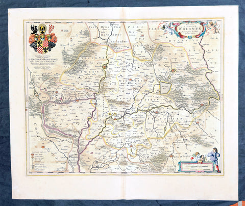
1662 Joan Blaeu Antique Map of Wołow County, Lower Silesia Voivodeship SW Poland
Antique Map
- Title : Ducatus Silesiae Wolanus Authore Jona Sculteto Sprotta Silesio
- Ref #: 93430
- Size: 24in x 20in (610mm x 510mm)
- Date : 1662
- Condition: (A) Very Good Condition
Description:
This beautifully hand coloured original copper-plate engraved antique, rare map of Wolow County, located at the time of publication in the Duchy of Głogow, in Lower Silesia, today SW Poland, was published in Joan Blaeu greatest publication, the first 1662 French edition of Atlas Major,.
As this map was only published over a 10 year period, as most of the plates were destroyed in the disasterous 1672 fire that wiped out the Blaeu publishing house, this map is extremely rare especially with original hand colour, such as this map.
General Definitions:
Paper thickness and quality: - Heavy and stable
Paper color : - off white
Age of map color: - Original
Colors used: - Yellow, green, blue, pink
General color appearance: - Authentic
Paper size: - 24in x 20in (610mm x 510mm)
Plate size: - 21in x 16 1/2in (535mm x 420mm)
Margins: - Min 1in (25mm)
Imperfections:
Margins: - Light soiling
Plate area: - Offsetting
Verso: - Offsetting
Background:
Wolow is a town in Lower Silesian Voivodeship in south-western Poland. It is the seat of Wołów County and Gmina Wołów. It lies approximately 38 kilometres north-west of the regional capital Wrocław.
The area around Wołów has been settled since prehistoric times. It became part of the emerging Polish state in the late 10th century under Mieszko I of Poland. The town was first mentioned in 1157 when a wooden castle founded by Senior Duke of Poland Władysław II the Exile is documented, which developed into a castle complex, which was again mentioned in 1202. Two villages developed near the castle, one of them called Wołowo. Probably in the second half of the 13th century the town was founded near Wołowo and partially on the soil of the second village. Wołów received Magdeburg town rights about 1285 at the time of German Ostsiedlung in the region; a Vogt is mentioned in 1288.
At that time Wołów belonged to the Duchy of Głogów, after 1312 to the Duchy of Oleśnica. With the duchy it came under the suzerainty of Bohemia in 1328. From 1473 dates the oldest known seal of the town, which already shows an ox, as do all later seals. Wołów was ruled by local Polish dukes until 1492, and soon after, in 1495, it came into the possession of the Czech Podiebrad family, then in 1517 it came into the hands the Hungarian magnate Johann Thurzó, before returning to Piast rule in 1523, by passing to the Duchy of Legnica. It remained there until the Piast dukes of Legnica-Brzeg-Wołów died out in 1675. As a result of the Thirty Years War, the towns population fell by half.
The Protestant Reformation was introduced to the town in 1522 by duke Frederick II. After the extinction of the local Piasts the duchy passed to the House of Habsburg, which opposed the Protestant denomination in the town, as part of the Counter-Reformation. In 1682 the towns parish church was closed and given to the Catholics. According to the Treaty of Altranstädt the church however was already returned to the Protestants in 1707 and stayed Protestant until 1945. The small Catholic minority in return received a Josephinian curacy.
In 1742 Wołów was annexed by Prussia. The duchy was divided into two districts and the town became county seat of one of the districts. The structure of the town was, until 1700, defined by craft, especially clothiers. As the seat of a duchy and a district administrative function however became more and more important. The industrialization played only a minor role and mostly affected smaller companies of the timber industry. In 1781 the city suffered a fire.
The town was part of Germany from 1871 to 1945. In January 1945 – just before town was taken by the Red Army – the Wehrmacht evacuated the German population westwards.

1662 Joan Blaeu Complete Set of 9 Antique Maps of North America from Atlas Major, 1st Edition
Antique Map
- Titles:
1. Extrema Americae....Terra Nova Francia;
2. Nova Belgica Et Anglia Nova;
3. Nova Virginiae Tabula;
4. Virginiae partis australis, et Floridae;
5. Nova Hispania;
6. Yucatan...Guatimala;
7. Insulae Americanae;
8. Canibales Insulae;
9. Mappa Aestivarum Insularum Alias Barmudas - Sizes: 24in x 20 1/2in (610mm x 520mm)ea
- Condition: (A+) Fine Condition
- Date: 1662
- Ref #: BlaeuNA 1662
Description:
This is a unique opportunity to acquire a complete set of 9 maps of North America published by Joan Blaeus in the monumental & rare 1st 1662 Latin edition of Atlas Major. The maps cover the geographical detail of Canada, North America, Mexico, The Caribbean & Central America. Please see the background section below for details of each map. All maps have wide original margins & colour on strong sturdy paper.
Joan Blaeus 11 volumes of Atlas Major, is considered by many to be the greatest atlas set ever published. It excels in comprehensiveness, engraving, color, and overall production. The first edition was published in Latin in 1662 and was subsequently published in French, Dutch, German, and Spanish over the next 10 years.
On the 23rd of February 1672, a fire broke out in central Amsterdam, that ended the reign of one of the greatest & most prolific publishers of printed maps and atlases in publishing history. The Blaeu family had reached its zenith 10 years previously, with the publication of its greatest achievement, the Atlas Major or Great Atlas, consisting of 11 volumes, with geographical detail reflecting many of the achievements of the Golden Age of the United Netherlands. Blaeus Atlas Major were the most expensive books printed in the 17th century.
General Definitions:
Paper thickness and quality: - Heavy and stable
Paper color : - off white
Age of map color: - Original
Colors used: - Blue, pink, red, green, yellow
General color appearance: - Authentic
Paper size: - 24in x 20 1/2in (610mm x 520mm)
Plate size: - Various, pls see below
Margins: - Min 1in (25mm) min
Imperfections:
Margins: - Pls see below
Plate area: - Pls see below
Verso: - Pls see below
Background:
1. Extrema Americae ( Eastern Canada) - Rare only published in Atlas Major. Derived mainly from the Samuel de Champlain Nouvelle France map of 1632, this map reflects the growing financial importance of the waters of New France to Europe.
Plate: 22 1/2in x 17 3/4in.
Condition: Age toning, text show-through & browning to image.
2. Nova Belgica Et Anglia Nova (New England) - NE America, centering on New York and Manhattan from Virginia to the St Lawrence River. This map is noted for the fact that its primary source is the first manuscript figurative map of Adriaen Block from 1614. Indeed it is the first full representation of it in print. It is one of the earliest to name Nieu Amsterdam. Block, a Dutch fur trader, explored the area between Cape Cod and Manhattan, examining the bays and rivers along the way.
Plate: 19 1/2in x 15 1/2in
Condition: Age toning, text show-through & browning to image.
3. Nova Virginiae Tabula (John Smiths Virginia & Chesapeake Bay) This map was printed from a plate engraved by Dirk Grijp from a previous plates by Henricus Hondius.
Plate: 19in x 15in
Condition: Light age toning
4. Virginiae partis australis, et Floridae Virginia, the Carolinas & Georgia.
Plate: 20in x 15in
Condition: Light age toning
5. Nova Hispania et Nova Galicia Western Mexico
Plate: 19 1/2in x 15 1/2in
Condition: Light age toning
6. Yucatan...Guatimala (Yucatan, Central America) Rare only published in Atlas Major.
Plate: 20 1/2in x 16 1/2in
Condition: Light age toning
7. Insulae Americana (GOM, Caribbean)
Plate: 20 1/2in x 15in
Condition: Light age toning
8. Canibales Insulae (Lesser Antilles Islands) Rare, printed only in Atlas Major
Plate: 21in x 16 1/2in
Condition: Age toning
9. Mappa Aestivarum Insularum Alias Barmudas Dictarum Bermuda. Like all 17th century maps of Bermuda this map is based ultimately on the survey made by John Norwood, of the Bermuda Company, in 1618 in the form as published by the English map-maker John Speed in 1627.
Plate: 21in x 16in
Condition: Light age toning
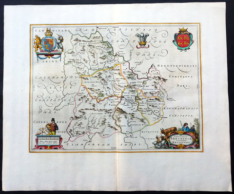
1664 Blaeu Large Antique Map of The Welsh County of Breknock
- Title : Comitatus Brechiniae Breknoke
- Ref #: 01-4244
- Size: 25 1/2in x 21 1/2in (650mm x 545mm)
- Date : 1664
- Condition: (A+) Fine Condition
Description:
This beautifully hand coloured original antique map of the Welsh county of Brecknock was published in the 1664 Dutch edition of Joan Blaeus Atlas Major.
Blaeus reference for the topographical data is from John Speeds maps from the 1611 Empire of Great Britaine - the beautiful decoration, though, is distinctly Blaeus.
This is a beautiful map with a deep impression, original margins, wonderful hand colouring and strong, stable paper. (Ref: Koeman; Tooley; M&B)
General Description:
Paper thickness and quality: - Heavy and stable
Paper color: - White
Age of map color: - Later
Colors used: - Yellow, pink, red, blue, green
General color appearance: - Authentic
Paper size: - 25 1/2in x 21 1/2in (650mm x 545mm)
Plate size: - 20in x 15in (510mm x 380mm)
Margins: - Min 2in (50mm)
Imperfections:
Margins: - None
Plate area: - None
Verso: - None
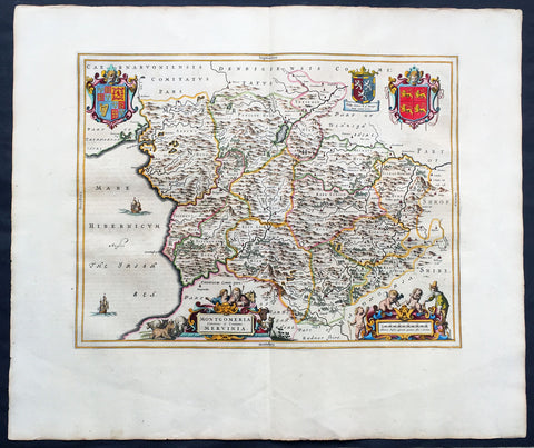
1664 Joan Blaeu Large Antqiue Map The Welsh County of Montgomery
Antique Map
-
Title : Montgomeria Comitatus et Comitatus Mervinia
- Date : 1664
- Condition: (A+) Fine Condition
- Ref: 01-4004
- Size: 25 1/2in x 21 1/2in (650mm x 545mm)
Description:
This beautifully hand coloured original antique map of the Welsh County of Montgomery was published in the 1664 Dutch edition of Joan Blaeus Atlas Major.
Blaeus reference for the topographical data is from John Speeds maps from the 1611 Empire of Great Britaine - the beautiful decoration, though, is distinctly Blaeus. (Ref: Koeman; Tooley; M&B)
General Description:
Paper thickness and quality: - Heavy and stable
Paper color: - White
Age of map color: - Early
Colors used: - Yellow, pink, red, blue, green
General color appearance: - Authentic
Paper size: - 25 1/2in x 21 1/2in (650mm x 545mm)
Plate size: - 20in x 16 1/2in (510mm x 420mm)
Margins: - Min 2in (50mm)
Imperfections:
Margins: - None
Plate area: - None
Verso: - None
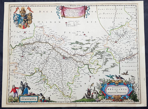
1670 Joan Blaeu Antique Map City & Region Breslau, Wroclaw, Silesia Lower Poland
- Title : Ducatus Breslanus sive Wratislaviensis
- Ref #: 93427
- Size: 23 1/2in x 17in (595mm x 435mm)
- Date : 1670
- Condition: (A+) Fine Condition
Description:
This beautifully hand coloured original copper-plate engraved antique, rare map of the City & Region Breslau, Wroclaw, Silesia Lower Poland, was published in Joan Blaeu greatest publication, the first 1670 German edition of Atlas Major,.
As this map was only published over a 10 year period, as most of the plates were destroyed in the disasterous 1672 fire that wiped out the Blaeu publishing house, this map is extremely rare especially with original hand colour, such as this map.
General Definitions:
Paper thickness and quality: - Heavy and stable
Paper color : - off white
Age of map color: - Original
Colors used: - Yellow, green, blue, pink
General color appearance: - Authentic
Paper size: - 23 1/2in x 17in (595mm x 435mm)
Plate size: - 21in x 16 1/2in (535mm x 420mm)
Margins: - Min 1/2in (12mm)
Imperfections:
Margins: - None
Plate area: - None
Verso: - None
Background:
Wrocław is a city in western Poland and the largest city in the historical region of Silesia. It lies on the banks of the River Oder in the Silesian Lowlands of Central Europe.
Wrocław is the historical capital of Silesia and Lower Silesia. Today, it is the capital of the Lower Silesian Voivodeship. The history of the city dates back over a thousand years; at various times, it has been part of the Kingdom of Poland, the Kingdom of Bohemia, the Kingdom of Hungary, the Habsburg Monarchy of Austria, the Kingdom of Prussia and Germany. Wrocław became part of Poland again in 1945 as part of the so-called Recovered Territories as a result of the border changes after the Second World War.