Products
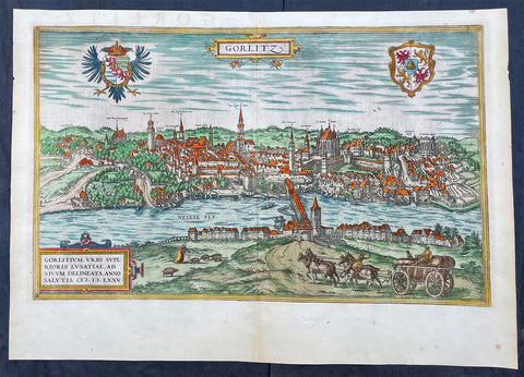
1574 Braun & Hogenberg Antique Map View of Gorlitz-Zgorzelec, Germany & Poland
- Title : Gorlitz
- Ref #: 93432
- Size: 22in x 16 1/2in (560mm x 420mm)
- Date : 1574
- Condition: (A+) Fine Condition
Description:
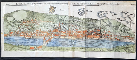
This original beautifully hand coloured copper plate engraved antique map, a birds eye view of the city of Gorlitz-Zgorzelec, in the state of Saxony, in the region of Lusatia, in far eastern Germany, on the border with Poland, was published in the 1574 edition of Braun & Hogenbergs atlas Civitates Orbis Terrarum
General Definitions:
Paper thickness and quality: - Heavy and stable
Paper color : - off white
Age of map color: - Original
Colors used: - Yellow, green, blue, pink
General color appearance: - Authentic
Paper size: - 22in x 16 1/2in (560mm x 420mm)
Plate size: - 20in x 12 1/2in (510mm x 320mm)
Margins: - Min 1in (25mm)
Imperfections:
Margins: - None
Plate area: - None
Verso: - None
Background:
As a small Sorbian village named Gorelic in the Margraviate of Meissen, a frontier march of the Holy Roman Empire, Gorlitz was temporarily conquered and held by the Kingdom of Poland during Bolesław I Chrobrys invasion of Lusatia between 1002 and 1031, after which the region fell back to the Margraviate of Meissen. In 1075, the village was assigned to the Duchy of Bohemia. The date of the towns foundation is unknown. However, Goreliz was first mentioned in a document from the King of Germany, and later Holy Roman Emperor, Henry IV in 1071. This document granted Gorlitz to the Diocese of Meissen, then under Bishop Benno of Meissen. Currently, this document can be found in the Saxony State Archives in Dresden.[3] The origin of the name Gorlitz is derived from the Slavic word for burned land,[4] referring to the technique used to clear land for settlement. Zgorzelec and Czech Zhořelec have the same derivation. In the 13th century the village gradually became a town. Due to its location on the Via Regia, an ancient and medieval trade route, the settlement prospered.
In the following centuries Gorlitz was a wealthy member of the Lusatian League, which consisted of Bautzen, Gorlitz, Kamenz, Lauban, Löbau and Zittau. In 1352 during the reign of Casimir the Great, Lusatian German colonists from Gorlitz founded the town of Gorlice in southern Poland near Kraków.
The Protestant Reformation came to Gorlitz in the early 1520s and by the last half of the 16th century, it and the surrounding vicinity, became almost completely Lutheran.
After suffering for years in the Thirty Years War, the region of Upper Lusatia (including Gorlitz) was ceded to the Electorate of Saxony in 1635. After the Napoleonic Wars, the 1815 Congress of Vienna transferred the town from the Kingdom of Saxony to the Kingdom of Prussia. Gorlitz was subsequently administered within the Province of Silesia, and, after World War I, the Province of Lower Silesia, until 1945.
From 1815 until 1918, Gorlitz belonged to the Province of Silesia in the Kingdom of Prussia, and later to the Province of Lower Silesia in the Free State of Prussia. It is the largest town of the former Province of Lower Silesia that lies west of the Oder-Neisse line and hence remained in Germany after World War II. Today, Gorlitz lies opposite the Polish town of Zgorzelec, which was part of Gorlitz until 1945. Together they form the German-Polish Euro City of Gorlitz-Zgorzelec.
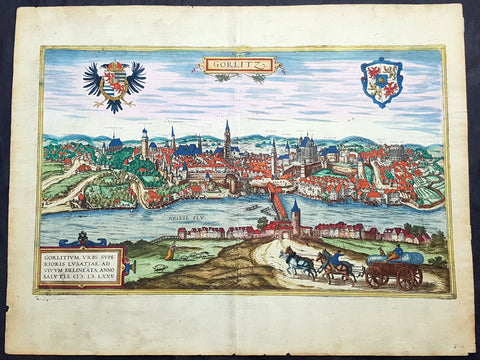
1574 Braun & Hogenberg Antique Map View of Gorlitz-Zgorzelec, Germany & Poland
- Title : Gorlitz
- Ref #: 93431
- Size: 22in x 16 1/2in (560mm x 420mm)
- Date : 1574
- Condition: (A+) Fine Condition
Description:
This original beautifully hand coloured copper plate engraved antique map a birds eye view of the Gorlitz, in the state of Saxony, in the region of Lusatia, in far eastern Germany, on the border with Poland, was published in the 1574 edition of Braun & Hogenbergs atlas Civitates Orbis Terrarum
General Definitions:
Paper thickness and quality: - Heavy and stable
Paper color : - off white
Age of map color: - Original
Colors used: - Yellow, green, blue, pink
General color appearance: - Authentic
Paper size: - 22in x 16 1/2in (560mm x 420mm)
Plate size: - 20in x 12 1/2in (510mm x 320mm)
Margins: - Min 1in (25mm)
Imperfections:
Margins: - Light soiling
Plate area: - None
Verso: - Light soiling
Background:
As a small Sorbian village named Gorelic in the Margraviate of Meissen, a frontier march of the Holy Roman Empire, Gorlitz was temporarily conquered and held by the Kingdom of Poland during Bolesław I Chrobrys invasion of Lusatia between 1002 and 1031, after which the region fell back to the Margraviate of Meissen. In 1075, the village was assigned to the Duchy of Bohemia. The date of the towns foundation is unknown. However, Goreliz was first mentioned in a document from the King of Germany, and later Holy Roman Emperor, Henry IV in 1071. This document granted Gorlitz to the Diocese of Meissen, then under Bishop Benno of Meissen. Currently, this document can be found in the Saxony State Archives in Dresden.[3] The origin of the name Gorlitz is derived from the Slavic word for burned land,[4] referring to the technique used to clear land for settlement. Zgorzelec and Czech Zhořelec have the same derivation. In the 13th century the village gradually became a town. Due to its location on the Via Regia, an ancient and medieval trade route, the settlement prospered.
In the following centuries Gorlitz was a wealthy member of the Lusatian League, which consisted of Bautzen, Gorlitz, Kamenz, Lauban, Löbau and Zittau. In 1352 during the reign of Casimir the Great, Lusatian German colonists from Gorlitz founded the town of Gorlice in southern Poland near Kraków.
The Protestant Reformation came to Gorlitz in the early 1520s and by the last half of the 16th century, it and the surrounding vicinity, became almost completely Lutheran.
After suffering for years in the Thirty Years War, the region of Upper Lusatia (including Gorlitz) was ceded to the Electorate of Saxony in 1635. After the Napoleonic Wars, the 1815 Congress of Vienna transferred the town from the Kingdom of Saxony to the Kingdom of Prussia. Gorlitz was subsequently administered within the Province of Silesia, and, after World War I, the Province of Lower Silesia, until 1945.
From 1815 until 1918, Gorlitz belonged to the Province of Silesia in the Kingdom of Prussia, and later to the Province of Lower Silesia in the Free State of Prussia. It is the largest town of the former Province of Lower Silesia that lies west of the Oder-Neisse line and hence remained in Germany after World War II. Today, Gorlitz lies opposite the Polish town of Zgorzelec, which was part of Gorlitz until 1945. Together they form the German-Polish Euro City of Gorlitz-Zgorzelec.
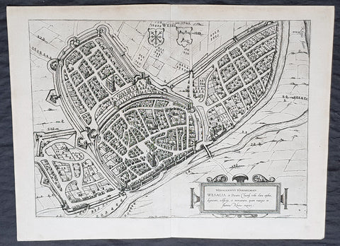
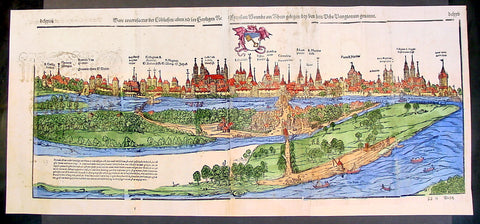
1574 Braun & Hogenberg Antique Map View of Wesel North Rhine-Westphalia, Germany
- Title : Hermannus Hammelman Wesalia in Ducatu Cliuensi
- Size: 21in x 16in (545mm x 410mm)
- Condition: (A+) Fine Condition
- Date : 1574
- Ref #: 81068-1
Description:
This original copper-plate engraved antique map, plan, a birds eye view of city of Wesel in North Rhine-Westphalia, in western Germany was published by Georg Braun & Frans Hogenberg for the 1574 atlas of town plans Civiates Orbis Terrarum intended as a companion to Abraham Ortelius master Atlas Theatrum Orbis Terrarum published in 1570.
General Definitions:
Paper thickness and quality: - Heavy and stable
Paper color : - off white
Age of map color: -
Colors used: -
General color appearance: -
Paper size: - 21in x 16in (545mm x 410mm)
Plate size: - 19in x 13 1/2in (480mm x 340mm)
Margins: - Min 1in (25mm)
Imperfections:
Margins: - None
Plate area: - None
Verso: - None
Background:
Wesel is a city in North Rhine-Westphalia, Germany. It is the capital of the Wesel district.
The city originated from a Franconian manor that was first recorded in the 8th century. In the 12th century, the Duke of Clèves took possession of Wesel. The city became a member of the Hanseatic League during the 15th century. Wesel was second only to Cologne in the lower Rhine region as an entrepôt. It was an important commercial centre: a clearing station for the trans-shipment and trading of goods.
In 1590 the Spanish captured Wesel after a four-year siege. The city changed hands between the Dutch and Spanish several times during the Eighty Years War. In 1672 a French force under Louis II de Bourbon, Prince de Condé captured the city. Wesel was inherited by the Hohenzollerns of the Margraviate of Brandenburg in 1609 but they were unable to take control of Wesel until the Treaty of Nijmegen in 1678. Although the city had been heavily fortified the Prussians evacuated the city during the Seven Years War and it was occupied by the French. It was returned to Prussia at the end of the war. Friedrich Wilhelm von Dossow was the Prussian Governor of Wesel during the 18th century. Wesel was ceded to the French in 1805 under the treaty of Schönbrunn. The French heavily fortified the city constructing a rectangular fort called the Citadelle Napoleon at Büderich and the Citadelle Bonaparte on an island in the Rhine off Wesel. Though blockaded by the Allies in 1813 the city remained in French hands until after the Battle of Waterloo. After the Napoleonic Wars of the early 19th century, the city became part of the Prussian Rhine Province and the Citadelle Napoleon was renamed Fort Blücher.
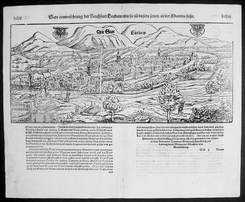
1574 Munster Large Antique Print - View of The German City of Landau, Bavaria
- Title : Die Statt Landaw
- Ref #: 22668
- Size: 16in x 13in (410mm x 330mm)
- Date : 1574
- Condition: (A+) Fine Condition
Description:
This large finely engraved original antique print a view of the Bavarian City of Landau NE of Munich was engraved in 1547 - the date is engraved at the foot of the image - and was published by Sebastian Munster in the 1574 edition of Cosmographia.
Landau or Landau in der Pfalz (pop. 41,821) is an autonomous (kreisfrei) city surrounded by the Südliche Weinstraße ("Southern Wine Route") district of southern Rhineland-Palatinate, Germany. It is a university town (since 1990), a long-standing cultural centre, and a market and shopping town, surrounded by vineyards and wine-growing villages of the Palatinate wine region. Landau lies east of the Palatinate forest, Europe's largest contiguous forest, direct on the German Wine Route.
Background: For a variety of reasons town plans were comparatively latecomers in the long history of cartography. Few cities in Europe in the middle ages had more than 20,00 inhabitants and even London in the late Elizabethan period had only 100-150,000 people which in itself was probably 10 times that of any other English city. The Nuremberg Chronicle in 1493 included one of the first town views of Jerusalem, thereafter, for most of the sixteenth century, German cartographers led the way in producing town plans in a modern sense. In 1544 Sebastian Munster issued in Basle hisCosmographia containing roughly sixty-six plans and views, some in the plan form, but many in the old panorama or birds eye view.
Sebastian Münster (1488-1552) was a German cartographer, cosmographer, and Hebrew scholar whose work Cosmographia (1544; "Cosmography") was the earliest German description of the world and a major work in the revival of geographic thought in 16th-century Europe. It had numerous editions in different languages including Latin, French, Italian, English, and even Czech. Altogether, about 40 editions of the Cosmographiaappeared between 1544 and 1628 and was one of the most successful and popular books of the 16th century. Münster was a major influence in popular thinking in Europe for the next 200 years.
This success was due not only to the level of descriptive detail but also to the fascinating full page maps & views as well as smaller woodcuts that were included in the text. Many of the woodcuts were executed by famous engravers of the time including Hans Holbein the Younger, Urs Graf, Hans Rudolph Manuel Deutsch, and David Kandel.
Aside from the well-known maps present in the Cosmographia, the text is thickly sprinkled with vigorous views: portraits of kings and princes, costumes and occupations, habits and customs, flora and fauna, monsters, wonders, and horrors about the known -- and unknown -- world, and was undoubtedly one of the most widely read books of its time.
Münster acquired the material for his book in three ways. Firstly he researched all available literary sources across Germany, Switzerland and other parts of Europe. Secondly he obtained original manuscript material from locals all over Europe for description of the countryside, cities, villages, towns, rivers and local history. Finally, he obtained further material first hand on his travels (primarily in south-west Germany, Switzerland, and Alsace).
In 1588 Sebastian Petri re-released Cosomgraphia and re-issued many of Munsters maps and views in the "copperplate style". The maps in this release were more sophisticated than with earlier publications ofCosomgraphia and were based on the 1570 release of Abraham Ortelius monumental work Theatrum Orbis Terrarum.(Ref: Tooley; M&B)
General Description:
Paper thickness and quality: - Light and stable
Paper color: - off white
Age of map color: -
Colors used: -
General color appearance: -
Paper size: - 16in x 13in (410mm x 330mm)
Plate size: - 16in x 13in (410mm x 330mm)
Margins: - 1/2in (12mm)
Imperfections:
Margins: - None
Plate area: -None
Verso: - None
1574 Munster Large Antique Print View of The City of Wormbs, Germany
- Title : Die Statt Wormbs
- Ref #: 22670
- Size: 27in x 13in (685mm x 330mm)
- Date : 1574
- Condition: (A) Very Good Condition
Description:
This large folding original antique print a View of the important German city ofWormbs, south of Hamburg was published in the 1574 release of Sebastian MunstersCosmographia published by Sebastian Petri, Basle.
(This is a reasonably scarce map as the large fold out maps in Cosmographia were easily damaged and lost)
Background: For a variety of reasons town plans were comparatively latecomers in the long history of cartography. Few cities in Europe in the middle ages had more than 20,00 inhabitants and even London in the late Elizabethan period had only 100-150,000 people which in itself was probably 10 times that of any other English city. The Nuremberg Chronicle in 1493 included one of the first town views of Jerusalem, thereafter, for most of the sixteenth century, German cartographers led the way in producing town plans in a modern sense. In 1544 Sebastian Munster issued in Basle his Cosmographia containing roughly sixty-six plans and views, some in the plan form, but many in the old panorama or birds eye view. (Ref: Tooley; M&B)
General Description:
Paper thickness and quality: - Heavy and stable
Paper color: - off white
Age of map color: - Later
Colors used: - Green, blue, yellow, pink
General color appearance: - Authentic
Paper size: - 27in x 13in (685mm x 330mm)
Plate size: - 25in x 10in (635 x 255m)
Margins: - 1/2in (12mm)
Imperfections:
Margins: - Light soiling
Plate area: -Folds re-joined small loss, light soiling, light creasing
Verso: - Light soiling, colour show through, half the map backed in archival material
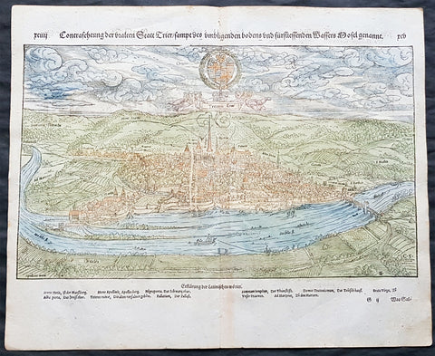
1574 Sebastian Munster Antique Map - City View of Trier, Rhineland-Palatinate, Germany
- Title : Die Statt Treir
- Date : 1574
- Condition: (A+) Fine Condition
- Ref # : 33540
- Size : 16in x 13in (405mm x 330mm)
Description:
This finely engraved hand coloured original antique double page view of the German city of Trier in the state of Rhineland-Palatinate was published in the early 1574 edition of Sebastian Munsters Cosmographia by Sebastian Petri, Basle.
Sebastian Petri re-release of Cosomgraphia in 1588 produced some fine woodcut maps in the copperplate style. The maps in this release were more sophisticated than with earlier publications of Cosomgraphia and were based on the 1570 release of Abraham Ortelius monumental work Theatrum Orbis Terrarum. For a variety of reasons town plans were comparatively latecomers in the long history of cartography. Few cities in Europe in the middle ages had more than 20,00 inhabitants and even London in the late Elizabethan period had only 100-150,000 people which in itself was probably 10 times that of any other English city. The Nuremberg Chronicle in 1493 included one of the first town views of Jerusalem, thereafter, for most of the sixteenth century, German cartographers led the way in producing town plans in a modern sense. In 1544 Sebastian Munster issued in Basle his Cosmographia containing roughly sixty-six plans and views, some in the plan form, but many in the old panorama or birds eye view. (Ref: Tooley; M&B)
General Description:
Paper thickness and quality: - Light and stable
Paper color: - Off white
Age of map color: - Early
Colors used: - Yellow, green, blue
General color appearance: - Authentic
Paper size: - 16in x 13in (405mm x 330mm)
Margins: - Min ½in (12mm)
Imperfections:
Margins: - None
Plate area: - None
Verso: - None
Background:
Trier is a city in Germany on the banks of the Moselle. Trier lies in a valley between low vine-covered hills of red sandstone in the west of the state of Rhineland-Palatinate, near the border with Luxembourg and within the important Moselle wine region. The German philosopher and one of the founders of Marxism, Karl Marx was born in the city in 1818.
Founded by the Celts in the late-4th century BC as Treuorum, it was later conquered by the Romans in the late-1st century BC and renamed Trevorum or Augusta Treverorum (Latin for The City of Augustus among the Treveri). Trier may be the oldest city in Germany. It is also the oldest seat of a bishop north of the Alps. In the Middle Ages, the Archbishop-Elector of Trier was an important prince of the church, as the archbishop-electorate controlled land from the French border to the Rhine. The Archbishop-Elector also had great significance as one of the seven electors of the Holy Roman Empire.
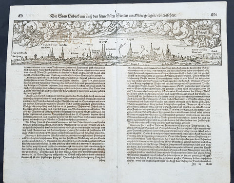
1574 Sebastian Munster Antique Map Birds Eye View of the City of Lubeck, Germany
- Title : Die Statt Lubeck
- Date : 1574
- Condition: (A+) Fine Condition
- Ref # : 22708
- Size : 15in x 13in (380mm x 340mm)
Description:
This fine original wood block engraved antique map a birds eye view of the German city of Lubeck, in the northern German state Schleswig-Holstein was published in the German Section of Sebastian Munsters 1574 edition of Cosmographia, Das ist: Beschreibung der gantzen Welt, Darinnen Aller Monarchien Keyserthumben, Königreichen, Fürstenthumben, Graff- und Herrschafften, Länderen, Stätten und Gemeinden.Ursprung (Cosmographia, that is: description of the whole world, in it all monarchies Keyser thumben, kingdoms, prince thumben, graff and herrschafften, countries, places and municipalities.)
Lübeck is a city in Schleswig-Holstein, northern Germany, and one of the major ports of Germany, on the river Trave.
In the 14th century Lübeck became the Queen of the Hanseatic League, being by far the largest and most powerful member of that medieval trade organization. In 1375 Emperor Charles IV named Lübeck one of the five Glories of the Empire, a title shared with Venice, Rome, Pisa and Florence. Several conflicts about trading privileges resulted in fighting between Lübeck (with the Hanseatic League) and Denmark and Norway – with varying outcome. While Lübeck and the Hanseatic League prevailed in conflicts in 1435 and 1512, Lübeck lost when it became involved in the Count\'s Feud, a civil war that raged in Denmark from 1534 to 1536. Lübeck also joined the pro-Lutheran Schmalkaldic League of the mid-16th century.
After its defeat in the Count\'s Feud, Lübeck\'s power slowly declined. The city remained neutral in the Thirty Years\' War of 1618–1648, but the combination of the devastation from the decades-long war and the new transatlantic orientation of European trade caused the Hanseatic League – and thus Lübeck with it – to decline in importance. However, even after the de facto disbanding of the Hanseatic League in 1669, Lübeck still remained an important trading town on the Baltic Sea.
General Definitions:
Paper thickness and quality: - Heavy and stable
Paper color : - off white
Age of map color: -
Colors used: -
General color appearance: -
Paper size: - 16in x 13in (410mm x 330mm)
Plate size: - 16in x 13in (410mm x 330mm)
Margins: - Min 1in (25mm)
Imperfections:
Margins: - None
Plate area: - Folds as issued
Verso: - None
Background:
Cosmographia, Das ist: Beschreibung der gantzen Welt, Darinnen Aller Monarchien Keyserthumben, Königreichen, Fürstenthumben, Graff- und Herrschafften, Länderen, Stätten und Gemeinden.Ursprung, Regiment, Reichthumb, Gewalt und.Beschaffenheit. Dessgleichen Aller deren, beyder Ständen, Regenten: Keysern, Königen, Bäpsten, Bischoffen.Genealogien und Stammbäumen.zusammen getragen. by Sebastian Münster was first published in 1544 and is the earliest German-language description of the world. It had numerous editions in different languages including Latin, French (translated by François de Belleforest), Italian, English, and Czech. The last German edition was published in 1628, long after Munsters death. The Cosmographia was one of the most successful and popular books of the 16th century. It passed through 24 editions in 100 years. This success was due to the notable woodcuts (some by Hans Holbein the Younger, Urs Graf, Hans Rudolph Manuel Deutsch, and David Kandel). It was most important in reviving geography in 16th-century Europe. Among the notable maps within Cosmographia is the map Tabula novarum insularum, which is credited as the first map to show the American continents as geographically discrete.
Munsters earlier geographic works were Germania descriptio (1530) and Mappa Europae (1536). In 1540, he published a Latin edition of Ptolemys Geographia with illustrations.
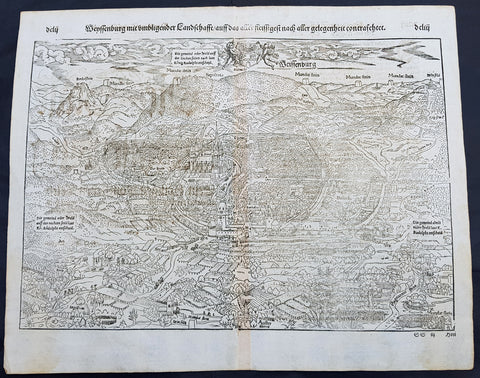
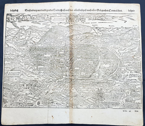
1574 Sebastian Munster Antique Map Birds Eye View of Weissenburg Bavaria Germany
- Title : Die Statt Wyssenburg
- Date : 1574
- Condition: (A+) Fine Condition
- Ref # : 22665
- Size : 15in x 13in (380mm x 340mm)
Description:
This fine original wood block engraved antique map a birds eye view of the German city of Weißenburg (Weissenburg) in Bavaria in Middle Franconia - identified by the cities Coate of Arms with double headed eagle atop of a castle - was published in the German Section of Sebastian Munsters 1574 edition of Cosmographia, Das ist: Beschreibung der gantzen Welt, Darinnen Aller Monarchien Keyserthumben, Königreichen, Fürstenthumben, Graff- und Herrschafften, Länderen, Stätten und Gemeinden.Ursprung (Cosmographia, that is: description of the whole world, in it all monarchies Keyser thumben, kingdoms, prince thumben, graff and herrschafften, countries, places and municipalities.)
Weißenburg in Bayern (formerly also Weißenburg im Nordgau) is a town in Middle Franconia, Germany. It is the capital of the district Weißenburg-Gunzenhausen. Weissenburg is located in central Bavaria, in the south of the administrative region Mittelfranken.
The history of Weißenburg is generally traced back to the Roman fort that was built in the area towards the end of the first century. The settlement, which included Thermae, lay on the border of the Roman Empire and on the Tabula Peutingeriana from the 4th century it had the name Biriciana. Germanic tribes destroyed the fort and settled in what is still the city centre. The first mention of the name Weißenburg is in a deed dating from 867. The city became the seat of a royal residence during the reign of the Franks and according to legend, Charlemagne stayed there to supervise the construction of Fossa Carolina.
The city became a Free Imperial City in 1296 and continued to grow until the Reformation. Following the example of Nuremberg the city joined the Protestant side but it suffered heavily in the ensuing wars. However, the rights of the city as a Free Imperial City and an Imperial Estate were restored in the final peace treaty and some growth resumed. Despite its insignificant size and economic importance, the city, like the other 50-odd free imperial cities, was virtually independent.
Weissenburg lost its independence in 1802 and became part of the Bavarian kingdom in 1806. It was however saved from insignificance with the construction of a railway between Nuremberg and Augsburg which goes through the city and which supported industrialisation. Following World War II over 6,000 refugees and people expelled from the territories which Germany lost settled in the city and have since played an important role in its industry and culture.
The many stages in the history of Weissenburg can still be seen today. There are many ruins from the Roman times. One of the finest is the remains of a Roman bath which was excavated in 1977 and has been turned into a museum. The city wall from the Middle Ages has survived almost intact with its towers and in the Gothic Town Hall the city\'s elected members have held their meetings from 1476.
General Definitions:
Paper thickness and quality: - Heavy and stable
Paper color : - off white
Age of map color: -
Colors used: -
General color appearance: -
Paper size: - 16in x 13in (410mm x 330mm)
Plate size: - 16in x 13in (410mm x 330mm)
Margins: - Min 1in (25mm)
Imperfections:
Margins: - None
Plate area: - None
Verso: - None
Background:
Cosmographia, Das ist: Beschreibung der gantzen Welt, Darinnen Aller Monarchien Keyserthumben, Königreichen, Fürstenthumben, Graff- und Herrschafften, Länderen, Stätten und Gemeinden.Ursprung, Regiment, Reichthumb, Gewalt und.Beschaffenheit. Dessgleichen Aller deren, beyder Ständen, Regenten: Keysern, Königen, Bäpsten, Bischoffen.Genealogien und Stammbäumen.zusammen getragen. by Sebastian Münster was first published in 1544 and is the earliest German-language description of the world. It had numerous editions in different languages including Latin, French (translated by François de Belleforest), Italian, English, and Czech. The last German edition was published in 1628, long after Munsters death. The Cosmographia was one of the most successful and popular books of the 16th century. It passed through 24 editions in 100 years. This success was due to the notable woodcuts (some by Hans Holbein the Younger, Urs Graf, Hans Rudolph Manuel Deutsch, and David Kandel). It was most important in reviving geography in 16th-century Europe. Among the notable maps within Cosmographia is the map Tabula novarum insularum, which is credited as the first map to show the American continents as geographically discrete.
Munsters earlier geographic works were Germania descriptio (1530) and Mappa Europae (1536). In 1540, he published a Latin edition of Ptolemys Geographia with illustrations.
1574 Sebastian Munster Large Antique Birds Eye City View of Heidelberg, Germany
- Title : Die Statt Heidelberg
- Size: 29in x 13in (740mm x 330mm)
- Ref #: 22692
- Date : 1574
- Condition: (B) Good Condition
Description:
This large hand coloured, original antique wood-block engraved birds-eye view of the German City of Heidelberg was published in the 1574 edition of Sebastian Munsters Cosmographia.
There were 2 large folding views in Cosmographia, both German cities, Wormbs and Heidelberg. As these were large folding views they were easily torn and damaged and so quiet rare, especially from the earlier editions.
The Cosmographia or Cosmography was first published in 1544 and is the earliest German-language description of the world.
It had numerous editions in different languages including Latin, French (translated by François de Belleforest), Italian, English, and Czech. The last German edition was published in 1628. The Cosmographia was one of the most successful and popular books of the 16th century and passed through 24 editions in 100 years. This success was due to the notable woodcuts (some by Hans Holbein the Younger, Urs Graf, Hans Rudolph Manuel Deutsch, and David Kandel). It was most important in reviving geography in 16th-century Europe. Among the notable maps within Cosmographia is the map Die Newe Welt oder Inseln, which is credited as the first map to show the American continents as geographically unique.
Munsters earlier geographic works were Germania descriptio (1530) and Mappa Europae (1536). In 1540, he published a Latin edition of Ptolemys Geographia, with numerous illustrations.
General Definitions:
Paper thickness and quality: - Heavy and stable
Paper color : - off white
Age of map color: - Original
Colors used: - Orange, yellow, blue, red
General color appearance: - Authentic
Paper size: - 29in x 13in (740mm x 330mm)
Plate size: - 29in x 13in (740mm x 330mm)
Margins: - Min 1/2in (12mm)
Imperfections:
Margins: - Left margin cropped to plate-mark, light age toning repair to right & bottom margins
Plate area: - Left plate small loss along centrer-fold, light spotting & creasing
Verso: - Left plate backed onto contemporary paper
Background:
Heidelberg is a college town in Baden-Wurttemberg situated on the river Neckar in south-west Germany.
Located about 78 km south of Frankfurt, Heidelberg is the fifth-largest city in the German state.
Founded in 1386, Heidelberg University is Germany\'s oldest and one of Europe\'s most reputable universities.
Heidelberg University played a leading part in the era of humanism and the Reformation, and the conflict between Lutheranism and Calvinism, in the 15th and 16th centuries. Heidelberg\'s library, founded in 1421, is the oldest existing public library in Germany. In April 1518, a few months after proclaiming his 95 Theses, Martin Luther was received in Heidelberg, to defend them. In 1537, the castle located higher up the mountain was destroyed by a gunpowder explosion. The duke\'s palace was built at the site of the lower castle.
The siege of Heidelberg 1622
Elector Frederick III, sovereign of the Electoral Palatinate from 1559 to 1576, commissioned the composition of a new Catechism for his territory. While the catechism\'s introduction credits the entire theological faculty here (at the University of Heidelberg) and all the superintendents and prominent servants of the church for the composition of the catechism, Zacharius Ursinus is commonly regarded as the catechism\'s principal author. Caspar Olevianus (1536–1587) was formerly asserted as a co-author of the document, though this theory has been largely discarded by modern scholarship. Johann Sylvan, Adam Neuser, Johannes Willing, Thomas Erastus, Michael Diller, Johannes Brunner, Tilemann Mumius, Petrus Macheropoeus, Johannes Eisenmenger, Immanuel Tremellius and Pierre Boquin are all likely to have contributed to the Catechism in some way. Frederick himself wrote the preface to the Catechism and closely oversaw its composition and publication. Frederick, who was officially Lutheran but had strong Reformed leanings, wanted to even out the religious situation of his highly Lutheran territory within the primarily Catholic Holy Roman Empire. The Council of Trent had just concluded with its conclusions and decrees against the Protestant faiths, and the Peace of Augsburg had only granted toleration for Lutheranism within the empire where the ruler was Lutheran. One of the aims of the catechism was to counteract the teachings of the Roman Catholic Church as well as Anabaptists and \"strict\" Gnesio-Lutherans like Tilemann Heshusius and Matthias Flacius, who were resisting Frederick\'s Reformed influences, particularly on the matter of Eucharist (the Lord\'s Supper). The Catechism-based each of its statements on biblical proof-texts, and Frederick himself would defend it as biblical, not reformed, at the 1566 Diet of Augsburg when he was called to answer to charges of violating the Peace of Augsburg. This was the Heidelberg Catechism, officially called the Catechism, or Christian Instruction, according to the Usages of the Churches and Schools of the Electoral Palatinate.
In November 1619, the royal crown of Bohemia was offered to the Elector, Frederick V. (He was married to Elizabeth, eldest daughter of James VI and I of Scotland and England, respectively.) Frederick became known as the Winter King, as he reigned for only one winter before the Imperial House of Habsburg regained the crown by force. His overthrow in 1621 marked the beginning of the Thirty Years War. In 1622, after a siege of two months, the armies of the Catholic League, commanded by Johann Tserclaes, Count of Tilly, captured the town. Tilly gave the famous Bibliotheca Palatina from the Church of the Holy Spirit to the Pope as a present. The Catholic Bavarian branch of the House of Wittelsbach gained control over the Palatinate and the title of Prince-Elector. In 1648, at the end of the war, Frederick Vs son Charles I Louis, Elector Palatine, was able to recover his titles and lands.
In late 1634 Imperialist forces attempted to take back the city, as the Swedish army had conquered it. They quickly took the city, but were unable to take the castle. As they prepared to blow up its fortifications with gunpowder the French army arrived, 30,000 men strong, led by Urbain de Maillé-Brézé, who had fought in many battles and participated in the Siege of La Rochelle (1627–1628), and Jacques-Nompar de Caumont, duc de La Force. They ended the siege and drove off the Catholic forces.
To strengthen his dynasty, Charles I Louis arranged the marriage of his daughter Liselotte to Philip I, Duke of Orléans, brother of Louis XIV, king of France. In 1685, after the death of Charles Louis\' son, Elector Charles II, Louis XIV laid claim to his sister-in-laws inheritance. The Germans rejected the claim, in part because of religious differences between local Protestants and the French Catholics, as the Protestant Reformation had divided the peoples of Europe. The War of the Grand Alliance ensued. In 1689, French troops took the town and castle, bringing nearly total destruction to the area in 1693. As a result of the destruction due to repeated French invasions related to the War of the Palatinate Succession coupled with severe winters, thousands of Protestant German Palatines emigrated from the lower Palatinate in the early 18th century. They fled to other European cities and especially to London (where the refugees were called the poor Palatines). In sympathy for the Protestants, in 1709–1710, Queen Anne\'s government arranged transport for nearly 6,000 Palatines to New York. Others were transported to Pennsylvania, and to South Carolina. They worked their passage and later settled in the English colonies there.
In 1720, after assigning a major church for exclusively Catholic use, religious conflicts with the mostly Protestant inhabitants of Heidelberg caused the Roman Catholic Prince-Elector Charles III Philip to transfer his residence to nearby Mannheim. The court remained there until the Elector Charles Theodore became Elector of Bavaria in 1777 and established his court in Munich. In 1742, Elector Charles Theodore began rebuilding the Palace. In 1764, a lightning bolt destroyed other palace buildings during reconstruction, causing the work to be discontinued.
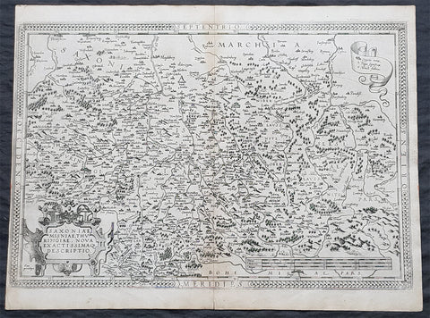
1575 Abraham Ortelius Antique Map Obersachsen, Meissen and Thuringen, Germany
- Title : Saxoniae Misniae, Thuringiae, Nova Exactissimaq Descriptio
- Size: 20 1/2in x 15 1/2in (520mm x 390mm)
- Condition: (A+) Fine Condition
- Date : 1587
- Ref #: 30032
Description:
These original copper-plate engraved antique map of the Obersachsen, Meissen and Thuringen regions of Germany was published in the 1575 French edition of Abraham Ortelius Atlas Theatrum Orbis Terrarum.
General Definitions:
Paper thickness and quality: - Heavy and stable
Paper color : - off white
Age of map color: -
Colors used: -
General color appearance: -
Paper size: - 20 1/2in x 15 1/2in (520mm x 390mm)
Plate size: - 20in x 13 1/2in (510mm x 345mm)
Margins: - Min 1/4in (4mm)
Imperfections:
Margins: - Light soiling
Plate area: - None
Verso: - Soiling
Background:
Ortelius regional map of Germany, showing the area between Berlin and Braunschweig in the north, to Prague in the south and Silesia in the east. With Chemnitz, Dresden, Leipzig, Wittenberg and Erfurt
1598 Sebastian Munster Antique Map Birds Eye View of Luneburg Hamburg, Germany
- Title : Die Statt Leunenburg
- Date : 1598
- Condition: (A) Very Good Condition
- Ref # : 30328
- Size : 15in x 13in (380mm x 340mm)
Description:
This fine original wood block engraved antique map a birds eye view of the German city of Lüneburg (Lunenburg) incorporated into the city of Hamburg in Lower Saxony was published in the German Section of Sebastian Munsters 1598 edition of Cosmographia, Das ist: Beschreibung der gantzen Welt, Darinnen Aller Monarchien Keyserthumben, Königreichen, Fürstenthumben, Graff- und Herrschafften, Länderen, Stätten und Gemeinden.Ursprung (Cosmographia, that is: description of the whole world, in it all monarchies Keyser thumben, kingdoms, prince thumben, graff and herrschafften, countries, places and municipalities.)
Lüneburg also called Lunenburg in English, is a town in the German state of Lower Saxony. It is located about 50 km southeast of Hamburg, and belongs to that citys wider metropolitan region.
With the demise of the Hanseatic League – and the absence of herrings around 1560 around Falsterbo in Scania – the biggest customers of Lüneburg\'s salt broke away and the town rapidly became impoverished. Hardly any new houses were built in central Lüneburg after this time, which is why the historical appearance of the town centre has remained almost unchanged until the present day.
The town became part of the Electorate of Hanover in 1708, the Kingdom of Westphalia in 1807, the First French Empire in 1810, the Kingdom of Hanover in 1814, and the Prussian Province of Hanover in 1866.
In the centuries after the collapse of the League, it was as if Lüneburg had fallen into a Sleeping Beauty slumber. Heinrich Heine, whose parents lived in Lüneburg from 1822 to 1826, called it his residence of boredom (Residenz der Langeweile). Near the end of the 19th century Lüneburg evolved into a garrison town, and it remained so until the 1990s.
General Definitions:
Paper thickness and quality: - Heavy and stable
Paper color : - off white
Age of map color: -
Colors used: -
General color appearance: -
Paper size: - 15in x 13in (380mm x 330mm)
Plate size: - 15in x 13in (380mm x 330mm)
Margins: - Min 1/4in (3mm)
Imperfections:
Margins: - None
Plate area: - Age toning along centerfold
Verso: - Age toning along centerfold, light soiling
Background:
Cosmographia, Das ist: Beschreibung der gantzen Welt, Darinnen Aller Monarchien Keyserthumben, Königreichen, Fürstenthumben, Graff- und Herrschafften, Länderen, Stätten und Gemeinden.Ursprung, Regiment, Reichthumb, Gewalt und.Beschaffenheit. Dessgleichen Aller deren, beyder Ständen, Regenten: Keysern, Königen, Bäpsten, Bischoffen.Genealogien und Stammbäumen.zusammen getragen. by Sebastian Münster was first published in 1544 and is the earliest German-language description of the world. It had numerous editions in different languages including Latin, French (translated by François de Belleforest), Italian, English, and Czech. The last German edition was published in 1628, long after Munsters death. The Cosmographia was one of the most successful and popular books of the 16th century. It passed through 24 editions in 100 years. This success was due to the notable woodcuts (some by Hans Holbein the Younger, Urs Graf, Hans Rudolph Manuel Deutsch, and David Kandel). It was most important in reviving geography in 16th-century Europe. Among the notable maps within Cosmographia is the map Tabula novarum insularum, which is credited as the first map to show the American continents as geographically discrete.
Munsters earlier geographic works were Germania descriptio (1530) and Mappa Europae (1536). In 1540, he published a Latin edition of Ptolemys Geographia with illustrations.
1598 Sebastian Munster Antique Map Birds Eye View of Weissenburg Bavaria Germany
- Title : Die Statt Wyssenburg
- Date : 1598
- Condition: (A+) Fine Condition
- Ref # : 30351
- Size : 15in x 13in (380mm x 340mm)
Description:
This fine original wood block engraved antique map a birds eye view of the German city of Weißenburg (Weissenburg) in Bavaria in Middle Franconia - identified by the cities Coate of Arms with double headed eagle atop of a castle - was published in the German Section of Sebastian Munsters 1598 edition of Cosmographia, Das ist: Beschreibung der gantzen Welt, Darinnen Aller Monarchien Keyserthumben, Königreichen, Fürstenthumben, Graff- und Herrschafften, Länderen, Stätten und Gemeinden.Ursprung (Cosmographia, that is: description of the whole world, in it all monarchies Keyser thumben, kingdoms, prince thumben, graff and herrschafften, countries, places and municipalities.)
Weißenburg in Bayern (formerly also Weißenburg im Nordgau) is a town in Middle Franconia, Germany. It is the capital of the district Weißenburg-Gunzenhausen. Weissenburg is located in central Bavaria, in the south of the administrative region Mittelfranken.
The history of Weißenburg is generally traced back to the Roman fort that was built in the area towards the end of the first century. The settlement, which included Thermae, lay on the border of the Roman Empire and on the Tabula Peutingeriana from the 4th century it had the name Biriciana. Germanic tribes destroyed the fort and settled in what is still the city centre. The first mention of the name Weißenburg is in a deed dating from 867. The city became the seat of a royal residence during the reign of the Franks and according to legend, Charlemagne stayed there to supervise the construction of Fossa Carolina.
The city became a Free Imperial City in 1296 and continued to grow until the Reformation. Following the example of Nuremberg the city joined the Protestant side but it suffered heavily in the ensuing wars. However, the rights of the city as a Free Imperial City and an Imperial Estate were restored in the final peace treaty and some growth resumed. Despite its insignificant size and economic importance, the city, like the other 50-odd free imperial cities, was virtually independent.
Weissenburg lost its independence in 1802 and became part of the Bavarian kingdom in 1806. It was however saved from insignificance with the construction of a railway between Nuremberg and Augsburg which goes through the city and which supported industrialisation. Following World War II over 6,000 refugees and people expelled from the territories which Germany lost settled in the city and have since played an important role in its industry and culture.
The many stages in the history of Weissenburg can still be seen today. There are many ruins from the Roman times. One of the finest is the remains of a Roman bath which was excavated in 1977 and has been turned into a museum. The city wall from the Middle Ages has survived almost intact with its towers and in the Gothic Town Hall the city\'s elected members have held their meetings from 1476.
General Definitions:
Paper thickness and quality: - Heavy and stable
Paper color : - off white
Age of map color: -
Colors used: -
General color appearance: -
Paper size: - 16in x 13in (410mm x 330mm)
Plate size: - 16in x 13in (410mm x 330mm)
Margins: - Min 1in (25mm)
Imperfections:
Margins: - Repair to bottom margin, no loss
Plate area: - Age toning along centerfold
Verso: - Light soiling
Background:
Cosmographia, Das ist: Beschreibung der gantzen Welt, Darinnen Aller Monarchien Keyserthumben, Königreichen, Fürstenthumben, Graff- und Herrschafften, Länderen, Stätten und Gemeinden.Ursprung, Regiment, Reichthumb, Gewalt und.Beschaffenheit. Dessgleichen Aller deren, beyder Ständen, Regenten: Keysern, Königen, Bäpsten, Bischoffen.Genealogien und Stammbäumen.zusammen getragen. by Sebastian Münster was first published in 1544 and is the earliest German-language description of the world. It had numerous editions in different languages including Latin, French (translated by François de Belleforest), Italian, English, and Czech. The last German edition was published in 1628, long after Munsters death. The Cosmographia was one of the most successful and popular books of the 16th century. It passed through 24 editions in 100 years. This success was due to the notable woodcuts (some by Hans Holbein the Younger, Urs Graf, Hans Rudolph Manuel Deutsch, and David Kandel). It was most important in reviving geography in 16th-century Europe. Among the notable maps within Cosmographia is the map Tabula novarum insularum, which is credited as the first map to show the American continents as geographically discrete.
Munsters earlier geographic works were Germania descriptio (1530) and Mappa Europae (1536). In 1540, he published a Latin edition of Ptolemys Geographia with illustrations.
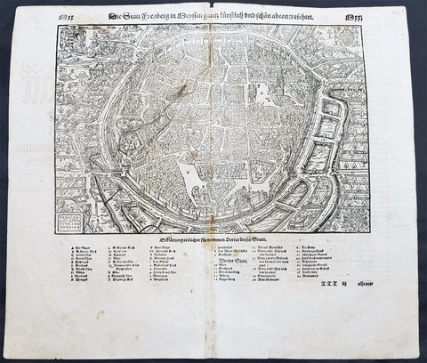
1598 Sebastian Munster Antique Map View of Freiberg, Saxony Southern Germany
- Title : Die Statt Freyberg
- Date : 1598
- Size: 15in x 13in (380mm x 330mm)
- Ref #: 30329
- Condition: (A+) Fine Condition
Description:
This large finely engraved original antique print a view of the German City of Freiberg, Saxony was published by Sebastian Munster in the 1598 edition of Cosmographia.
Freiberg (German for "free for mining activities") is a university and mining town in the Free State of Saxony, Germany. It is a so-called Große Kreisstadt (large county town) and the administrative centre of Mittelsachsendistrict.
Background:
For a variety of reasons town plans were comparatively latecomers in the long history of cartography. Few cities in Europe in the middle ages had more than 20,00 inhabitants and even London in the late Elizabethan period had only 100-150,000 people which in itself was probably 10 times that of any other English city. The Nuremberg Chronicle in 1493 included one of the first town views of Jerusalem, thereafter, for most of the sixteenth century, German cartographers led the way in producing town plans in a modern sense. In 1544 Sebastian Munster issued in Basle his Cosmographia containing roughly sixty-six plans and views, some in the plan form, but many in the old panorama or birds eye view.
General Definitions:
Paper thickness and quality: - Heavy and stable
Paper color : - off white
Age of map color: -
Colors used: -
General color appearance: -
Paper size: - 15in x 13in (380mm x 330mm)
Plate size: - 15in x 13in (380mm x 330mm)
Margins: - Min 1/2in (12mm)
Imperfections:
Margins: - None
Plate area: - Light age toning along centerfold
Verso: - Light age toning along centerfold
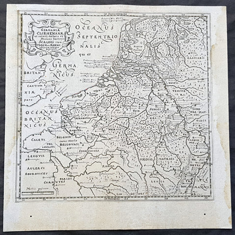
1611 Philipp Cluver Antique Map The Netherlands, Belgium, parts France & Germany
- Title : Germaniae Cisrhenanae ut interl. caesaris et Traiani suit imperii Scaldis item Mosae ac Rheni ostiorum antiqua Descriptio
- Size: 11 1/2in x 11 1/2in (295mm x 295mm)
- Condition: (A+) Fine Condition
- Date : 1611
- Ref #: 23967
Description:
This fine original wood-block engraved antique map of The Netherlands, Belgium, Northern France and parts of Western Germany was published in the 1611 edition of Philip Cluvers first publication Commentarius de tribus Rheni alveis, et ostiis; item. De Quinque populis quondam accolis; scilicet de Toxandris, Batavis, Caninefatibus, Frisiis, ac Marsacis. (Ref: King; Tooley; M&B)
General Definitions:
Paper thickness and quality: - Heavy and stable
Paper color : - off white
Age of map color: -
Colors used: -
General color appearance: -
Paper size: - 11 1/2in x 11 1/2in (295mm x 295mm)
Plate size: - 10in x 10in (255mm x 255mm)
Margins: - Min 1/2in (12mm)
Imperfections:
Margins: - Light age toning to left & right margins
Plate area: - None
Verso: - None
Background:
Clüver was an antiquary, who was given a special appointment at Leiden as geographer and put in charge of the university\'s library, but his lifes project, it developed, was a general study of the geography of Antiquity, based not only on classical literary sources, but — and this was his contribution — supplemented by wide travels and local inspections. He became virtually the founder of historical geography.
Clüvers first work, in 1611, concerning the lower reaches of the Rhine and its tribal inhabitants in Roman times (Commentarius de tribus Rheni alveis, et ostiis; item. De Quinque populis quondam accolis; scilicet de Toxandris, Batavis, Caninefatibus, Frisiis, ac Marsacis) touched a source of national pride among the Seventeen Provinces, for the Dutch were enjoying a twelve years truce in their Eighty Years War of liberation.
Cluver, Philipp 1580 – 1622
Clüver - also Klüwer, Cluwer, or Cluvier, Latinized as Philippus Cluverius and Philippi Cluverii) - was an Early Modern German geographer and historian.
Clüver was born in Danzig (Gdańsk), in Royal Prussia, a province of the Kingdom of Poland. After spending some time at the Polish court of Sigismund III Vasa, he began the study of law at the University of Leiden (Dutch Republic), but soon he turned his attention to history and geography, which were then taught there by Joseph Scaliger.
Clüver received science education from his father, who was Münzmeister at Danzig (coin master), but when Clüver went into different studies, his father stopped supporting his studies. He therefore travelled from Leiden across Hungary to Bohemia, where he did military service for a few years. While in Bohemia, he translated into Latin a defense by Baron Popel Lobkowitz, who was imprisoned. Upon his return to Leiden, he faced sanctions by the imperial (Habsburg) authorities for this, which however he could avoid with the help of his Leiden friends.
Clüver also travelled in England, Scotland, and France. He did all travel on foot, finally returning to Leiden, where (after 1616) he received a regular pension from the university. He died in Leiden.
Clüver was an antiquary, who was given a special appointment at Leiden as geographer and put in charge of the university\\\'s library, but his lifes project, it developed, was a general study of the geography of Antiquity, based not only on classical literary sources, but — and this was his contribution — supplemented by wide travels and local inspections. He became virtually the founder of historical geography.
Clüver\\\'s first work, in 1611, concerning the lower reaches of the Rhine and its tribal inhabitants in Roman times (Commentarius de tribus Rheni alveis, et ostiis; item. De Quinque populis quondam accolis; scilicet de Toxandris, Batavis, Caninefatibus, Frisiis, ac Marsacis) touched a source of national pride among the Seventeen Provinces, for the Dutch were enjoying a twelve years\\\' truce in their Eighty Years War of liberation.
Clüvers Germaniae antiquae libri tres (Leiden, 1616) depends on Tacitus and other Latin authors. A volume on the antiquities of Sicily, with notes on Sardinia and Corsica (Sicilia Antiqua cum minoribus insulis ei adjacentibus item Sardinia et Corsica), published at Leiden by Louis Elsevier in 1619, is a useful source, with many reference from writers of Antiquity and maps that are often detached and sold to map collectors. His Introductio in universam geographiam, totally 6 parts, (published posthumously from 1624) was the first comprehensive modern geography, and became a standard geographical textbook.
Clüver was also a prolific a writer on mathematical and theological subjects. He is remembered by collectors and historians of cartography for his edition of Ptolemys Geographia (based on Mercators edition of 1578) and for miniature atlases that were reprinted for most of the 17th century. Many of his maps were etched for him by Petrus Bertius.
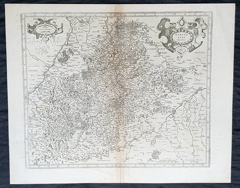
1628 Gerard Mercator & Henricus Hondius Antique Map of Duchy Wurttemberg Germany
- Title : Wirtenberg Ducatus...Per Geradum Mercatorem Cum Privilego
- Size: 21in x 17in (530mm x 430mm)
- Condition: (A+) Fine Condition
- Date : 1628
- Ref #: 26116
Description:
This original copper plate engraved antique map of Wurttemberg in todays Baden-Württemberg state in southern Germany, by Gerard Mercator was published by Henricus Hondius in the early 1628 French edition of Gerard Mercators Atlas.
These maps, published in the early editions of Mercators atlas, are the original maps drawn and engraved by Gerald Mercator in the mid to late 16th century, published by his son Rumold as an atlas, after his death, in 1595. After two editions the plates were purchased by Jodocus Hondius in 1604 and continued to be published until the mid 1630\'s when the plates were re-engraved and updated by Jan Jansson and Henricus Hondius.
General Definitions:
Paper thickness and quality: - Heavy and stable
Paper color : - off white
Age of map color: -
Colors used: -
General color appearance: -
Paper size: - 21in x 17in (530mm x 430mm)
Plate size: - 18 1/2in x 14in (475mm x 350mm)
Margins: - Min 1/2in (12mm)
Imperfections:
Margins: - Light age toning
Plate area: - Light toning along centerfold
Verso: - Light age toning
Background:
Württemberg is a historical German territory roughly corresponding to the cultural and linguistic region of Swabia. Together with Baden and Hohenzollern, two other historical territories, it now forms the Federal State of Baden-Württemberg. Württemberg was formerly also spelled Würtemberg and Wirtemberg.
The Duchy of Württemberg was a duchy located in the south-western part of the Holy Roman Empire. It was a member of the Holy Roman Empire from 1495 to 1806. The dukedoms long survival for nearly four centuries was mainly due to its size, being larger than its immediate neighbors. During the Protestant Reformation, Württemberg faced great pressure from the Holy Roman Empire to remain a member. Württemberg resisted repeated French invasions in the 17th and 18th centuries. Württemberg was directly in the path of French and Austrian armies who were engaged in the long rivalry between the House of Bourbon and the House of Habsburg. In 1803, Napoleon raised the duchy to be the Electorate of Württemberg of the Holy Roman Empire. On 1 January 1806, the last Elector assumed the title of King of Württemberg. Later this year, on 6 August 1806, the last Emperor, Francis II, abolished (de facto) the Holy Roman Empire.
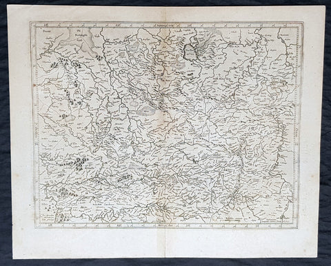
1628 Gerard Mercator & Henricus Hondius Antique Map of Westphalia, Germany
- Title : Tabula Seconde Westphalia...Per Geradum Mercatorem Cum Privilego...1627
- Size: 21in x 17in (530mm x 430mm)
- Condition: (A) Very Good Condition
- Date : 1628
- Ref #: 26109
Description:
This original copper plate engraved antique map of the Westphalia region of North Rhine-Westphalia, Germany, by Gerard Mercator was published by Henricus Hondius in the early 1628 French edition of Gerard Mercators Atlas.
These maps, published in the early editions of Mercators atlas, are the original maps drawn and engraved by Gerald Mercator in the mid to late 16th century, published by his son Rumold as an atlas, after his death, in 1595. After two editions the plates were purchased by Jodocus Hondius in 1604 and continued to be published until the mid 1630s by Henricus, when some of the plates were re-engraved and updated by Jan Jansson and Henricus Hondius.
General Definitions:
Paper thickness and quality: - Heavy and stable
Paper color : - off white
Age of map color: -
Colors used: -
General color appearance: -
Paper size: - 21in x 17in (530mm x 430mm)
Plate size: - 18 1/2in x 14in (475mm x 350mm)
Margins: - Min 1/2in (12mm)
Imperfections:
Margins: - Light age toning
Plate area: - Light toning along centerfold
Verso: - Light age toning
Background:
While the Northern Rhineland, Westphalia and Lippe are different historic territories of todays North Rhine-Westphalia, the old border between the former Rhine Province and the Province of Westphalia is also a language border. While in Westphalia and Lippe, people tend to speak West Low German dialects and especially the Westphalian variant of the Low German language, Central German and Low Franconian dialects are being spoken in the Northern Rhineland.
Westphalia is known for the 1648 Peace of Westphalia which ended the Thirty Years War, as the two treaties were signed in Münster and Osnabrück.
It is one of the regions that were part of all incarnations of the German state since the Early Middle Ages: the Holy Roman Empire, the Confederation of the Rhine, the German Confederation, the North German Confederation, the German Empire, the Weimar Republic and National Socialist Germany. After World War II it was a part of the British occupation zone which merged with the American zone to become the Bizone in 1947 and again merged with the French zone to become the Trizone in 1948. The current Federal Republic of Germany was founded on these territories making Westphalia a part of West Germany. It is a part of united Germany since 1990.
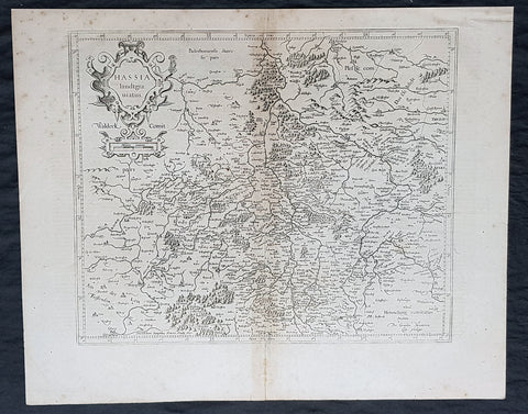
1628 Gerard Mercator & Henricus Hondius Antique Map State of Hesse, Germany
- Title : Hassia landtgrauiatus...Per Geradum Mercatorem Cum Privilego
- Size: 21in x 17in (530mm x 430mm)
- Condition: (A) Very Good Condition
- Date : 1628
- Ref #: 26107
Description:
This original copper plate engraved antique map of the State of Hesse or Hessia, in central Germany, by Gerard Mercator was published by Henricus Hondius in the early 1628 French edition of Gerard Mercators Atlas.
These maps, published in the early editions of Mercators atlas, are the original maps drawn and engraved by Gerald Mercator in the mid to late 16th century, published by his son Rumold as an atlas, after his death, in 1595. After two editions the plates were purchased by Jodocus Hondius in 1604 and continued to be published until the mid 1630s by Henricus, when some of the plates were re-engraved and updated by Jan Jansson and Henricus Hondius.
General Definitions:
Paper thickness and quality: - Heavy and stable
Paper color : - off white
Age of map color: -
Colors used: -
General color appearance: -
Paper size: - 21in x 17in (530mm x 430mm)
Plate size: - 18 1/2in x 14in (475mm x 350mm)
Margins: - Min 1/2in (12mm)
Imperfections:
Margins: - Light age toning
Plate area: - Light toning along centerfold
Verso: - Light age toning
Background:
Hesse officially the State of Hesse, is a federal state (Land) of the Federal Republic of Germany, with just over six million inhabitants. The state capital is Wiesbaden; the largest city is Frankfurt am Main.
In the 12th century, Hessengau was passed to Thuringia. In the War of the Thuringian Succession (1247–1264), Hesse gained independence and became a Landgraviate within the Holy Roman Empire. It shortly rose to primary importance under Landgrave Philip the Magnanimous, who was one of the leaders of German Protestantism. After Philips death in 1567, the territory was divided among his four sons from his first marriage (Philip was a bigamist) into four lines: Hesse-Kassel (or Hesse-Cassel), Hesse-Darmstadt, Hesse-Rheinfels, and the also previously existing Hesse-Marburg. As the latter two lines died out quite soon (1583 and 1605, respectively), Hesse-Kassel and Hesse-Darmstadt were the two core states within the Hessian lands. Several collateral lines split off during the centuries, such as in 1622, when Hesse-Homburg split off from Hesse-Darmstadt. In the late 16th century, Kassel adopted Calvinism, while Darmstadt remained Lutheran and subsequently the two lines often found themselves on different sides of a conflict, most notably in the disputes over Hesse-Marburg and in the Thirty Years War, when Darmstadt fought on the side of the Emperor, while Kassel sided with Sweden and France.
The Landgrave Frederick II (1720–1785) ruled as a benevolent despot, from 1760 to 1785. He combined Enlightenment ideas with Christian values, cameralist plans for central control of the economy, and a militaristic approach toward diplomacy.[16] He funded the depleted treasury of the poor nation by loaning 19,000 soldiers in complete military formations to Great Britain to fight in North America during the American Revolutionary War, 1776–1783. These soldiers, commonly known as Hessians, fought under the British flag. The British used the Hessians in several conflicts, including in the Irish Rebellion of 1798. For further revenue, the soldiers were loaned to other places as well. Most were conscripted, with their pay going to the Landgrave.
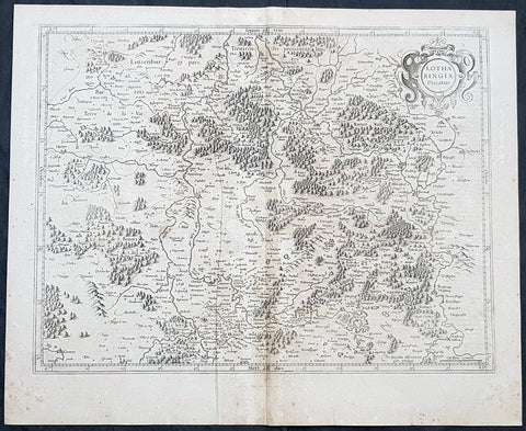
1628 Gerard Mercator Antique Map Lotharingia Region - Netherlands Germany France
- Title : Lotharingia Ducatus...Per Geradum Mercatorem Cum Privilegio
- Size: 21in x 17in (530mm x 430mm)
- Condition: (A) Very Good Condition
- Date : 1628
- Ref #: 26141
Description:
This original copper plate engraved antique map of the historical region of Lotharingia region of present-day Netherlands, Belgium, Luxembourg, North Rhine-Westphalia (Germany), Rhineland-Palatinate (Germany), Saarland (Germany), and Lorraine (France) by Gerard Mercator was published by Henricus Hondius in the early 1628 French edition of Gerard Mercators Atlas.
These maps, published in the early editions of Mercators atlas, are the original maps drawn and engraved by Gerald Mercator in the mid to late 16th century, published by his son Rumold as an atlas, after his death, in 1595. After two editions the plates were purchased by Jodocus Hondius in 1604 and continued to be published until the mid 1630\\\'s when the plates were re-engraved and updated by Jan Jansson and Henricus Hondius.
General Definitions:
Paper thickness and quality: - Heavy and stable
Paper color : - off white
Age of map color: -
Colors used: -
General color appearance: -
Paper size: - 21in x 17in (530mm x 430mm)
Plate size: - 20in x 15in (510mm x 380mm)
Margins: - Min 1/2in (12mm)
Imperfections:
Margins: - Age toning
Plate area: - Age toning
Verso: - Age toning
Lotharingia was a medieval successor kingdom of the Carolingian Empire, comprising the present-day Netherlands, Belgium, Luxembourg, North Rhine-Westphalia (Germany), Rhineland-Palatinate (Germany), Saarland (Germany), and Lorraine (France). It was named after King Lothair II who received this territory after the kingdom of Middle Francia of his father Lothair I was divided among his sons in 855.
Lotharingia was born out of the tripartite division in 855 of the kingdom of Middle Francia, which itself was formed after the threefold division of the Carolingian Empire by the Treaty of Verdun of 843. Conflict between East and West Francia over Lotharingia was based on the fact that these were the old Frankish homelands of Austrasia, so possession of them was of great prestige.
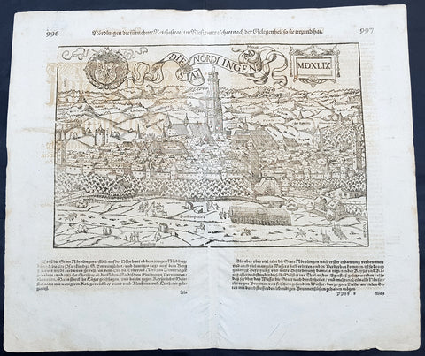
1628 Sebastian Munster & RMD Antique Map View Nordlingen Swabia, Bavaria Germany
- Title : Die Statt Nordlingen
- Ref #: 33587
- Size: 17in x 15in (435mm x 380mm)
- Date : 1628
- Condition: (A+) Fine Condition
Description:
This fine original wood block engraved antique map a birds eye view of the German town of Nördlingen in the Donau-Ries district, in Swabia, Bavaria,, was engraved by Hans Rudolf Manuel Deutsch (RMD) in 1549 - dated - and published in the German Section of Sebastian Munsters 1628 edition of Cosmographia, Das ist: Beschreibung der gantzen Welt, Darinnen Aller Monarchien Keyserthumben, Königreichen, Fürstenthumben, Graff- und Herrschafften, Länderen, Stätten und Gemeinden.Ursprung (Cosmographia, that is: description of the whole world, in it all monarchies Keyser thumben, kingdoms, prince thumben, graff and herrschafften, countries, places and municipalities.)
Hans Rudolf Manuel Deutsch (1525–1571) was a Swiss artist. He made several of the woodcuts for De re metallica (the metals and mining treatise by Georgius Agricola, the father of mineralogy) and for Sebastian Münsters Cosmographia.
Deutschs father, Niklaus Manuel Deutsch (the Elder), and Deutsch\'s brother, Niklaus Manuel Deutsch the Younger, were also artists. The elder Niklaus had taken the last name Manuel, but all three also commonly used Deutsch as part of their names and signed their paintings with initials ending in D.
Nördlingen is a town in the Donau-Ries district, in Swabia, Bavaria, Germany. The town was the location of two battles during the Thirty Years\' War, which took place between 1618–1648. Today it is one of only three towns in Germany that still has a completely established city wall, the other two being Rothenburg ob der Tauber and Dinkelsbühl.
General Definitions:
Paper thickness and quality: - Heavy and stable
Paper color : - off white
Age of map color: -
Colors used: -
General color appearance: -
Paper size: - 17in x 15in (435mm x 380mm)
Plate size: - 17in x 15in (435mm x 380mm)
Margins: - Min 1/2in (10mm)
Imperfections:
Margins: - Light offsetting
Plate area: - Light offsetting
Verso: - Light offsetting
Background:
Cosmographia, Das ist: Beschreibung der gantzen Welt, Darinnen Aller Monarchien Keyserthumben, Königreichen, Fürstenthumben, Graff- und Herrschafften, Länderen, Stätten und Gemeinden.Ursprung, Regiment, Reichthumb, Gewalt und.Beschaffenheit. Dessgleichen Aller deren, beyder Ständen, Regenten: Keysern, Königen, Bäpsten, Bischoffen.Genealogien und Stammbäumen.zusammen getragen. by Sebastian Münster was first published in 1544 and is the earliest German-language description of the world. It had numerous editions in different languages including Latin, French (translated by François de Belleforest), Italian, English, and Czech. The last German edition was published in 1628, long after Munsters death. The Cosmographia was one of the most successful and popular books of the 16th century. It passed through 24 editions in 100 years. This success was due to the notable woodcuts (some by Hans Holbein the Younger, Urs Graf, Hans Rudolph Manuel Deutsch, and David Kandel). It was most important in reviving geography in 16th-century Europe. Among the notable maps within Cosmographia is the map Tabula novarum insularum, which is credited as the first map to show the American continents as geographically discrete.
Munsters earlier geographic works were Germania descriptio (1530) and Mappa Europae (1536). In 1540, he published a Latin edition of Ptolemys Geographia with illustrations.
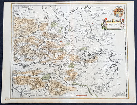
1638 Willem Blaeu Antique Map of Mansfeld Land, in SW Saxony-Anhalt, Germany
- Title : Mansfelda Comitatus
- Ref #: 70078
- Size: 22 1/2in x 17in (570mm x 430mm)
- Date : 1638
- Condition: (A+) Fine Condition
Description:
This beautifully hand coloured original copper-plate engraved antique map of the ancient region of Mansfeld Land located in the in southwestern region of Saxony-Anhalt, Germany - centering on the city of Mansfeld - by was published in the 1638 Latin edition edition of Willem Blaeus Atlas Novus.
General Definitions:
Paper thickness and quality: - Heavy and stable
Paper color : - off white
Age of map color: - Original
Colors used: - Blue, pink, red, green, yellow
General color appearance: - Authentic
Paper size: - 22 1/2in x 17in (570mm x 430mm)
Plate size: - 19 1/2in x 16 1/4in (495mm x 420mm)
Margins: - Min 1/2in (12mm)
Imperfections:
Margins: - Light age toning
Plate area: - None
Verso: - None
Background:
Mansfeld Land is a region in the southwestern corner of the German state of Saxony-Anhalt. The region derives its name from the counts of Mansfeld, who ruled this region for about 1,000 years.
The House of Mansfeld, whose members belonged to the Saxon nobility and served as counts in the Hassegau, was first documented in a 973 deed. The counts built Mansfeld Castle, whose foundations date back to the late 11th century, when one Hoyer of Mansfeld served as field marshal to Emperor Henry V. The first reference of the fortress coincides with the extinction of the elder line in 1229. The estates were inherited by the Lords of Querfurt, who also adopted the comital title, calling themselves Counts of Mansfeld from that time on.
The settlement of Mansfeld received town privileges in 1400, and grew through the development of copper and silver mining, an activity in which Hans Luder from Möhra, father to Martin Luther and Mansfeld citizen from 1484, was employed as a master smelter. Luthers family had arrived into a modest prosperity, he himself attended the local school between 1488 and 1496. The building known as Luther\'s School had to be torn down and rebuilt in 2000 due to structural problems. His parents house is preserved and today a museum. Luther also acted as an altar server at the St George parish church.
The Counts of Mansfeld had already lost Imperial immediacy in 1580. When the comital line finally became extinct in 1780, the estates around Mansfeld were incorporated into the Prussian Duchy of Magdeburg. The town retained the status of an independent city (Immediatstadt), it was temporarily part of the Napoleonic Kingdom of Westphalia and after the 1815 Congress of Vienna belonged to the Prussian Province of Saxony.
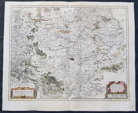
1639 Henricus Hondius Original Antique Map of the German State of Thuringia
- Title : Thuringia Lantgraviatus
- Date : 1639
- Size: 22 1/2in x 19in (570mm x 485mm)
- Ref #: 23434
- Condition: (A) Very Good Condition
Description:
This fine original antique map of the German State of Thuringia or Thüringen in central Germany was published by Henricus Hondius in the 1639 edition of Mercators Atlas.
The map centers on the city of Erfurt and alos includes major cities of Gotha, Weimar, Schwartzburg, Halle, Jena, Mulhausen and others
General Definitions:
Paper thickness and quality: - Heavy and stable
Paper color : - off white
Age of map color: - Original
Colors used: - Yellow, green, blue, pink
General color appearance: - Authentic
Paper size: - 22 1/2in x 19in (570mm x 485mm)
Plate size: - 20 1/2in x 16 1/2in (520mm x 420mm)
Margins: - Min 1in (25mm)
Imperfections:
Margins: - None
Plate area: - Light creasing along centerfold,
Verso: - Small repair to bottom left margin
Background:
Named after the Thuringii tribe who occupied it around AD 300, Thuringia came under Frankish domination in the 6th century.
Thuringia became a landgraviate in 1130 AD. After the extinction of the reigning Ludowingian line of counts and landgraves in 1247 and the War of the Thuringian Succession (1247–1264), the western half became independent under the name of \"Hesse\", never to become a part of Thuringia again. Most of the remaining Thuringia came under the rule of the Wettin dynasty of the nearby Margraviate of Meissen, the nucleus of the later Electorate and Kingdom of Saxony. With the division of the house of Wettin in 1485, Thuringia went to the senior Ernestine branch of the family, which subsequently subdivided the area into a number of smaller states, according to the Saxon tradition of dividing inheritance amongst male heirs. These were the \"Saxon duchies\", consisting, among others, of the states of Saxe-Weimar, Saxe-Eisenach, Saxe-Jena, Saxe-Meiningen, Saxe-Altenburg, Saxe-Coburg, and Saxe-Gotha; Thuringia became merely a geographical concept.
Thuringia generally accepted the Protestant Reformation, and Roman Catholicism was suppressed as early as 1520; priests who remained loyal to it were driven away and churches and monasteries were largely destroyed, especially during the German Peasants\' War of 1525. In Mühlhausen and elsewhere, the Anabaptists found many adherents. Thomas Müntzer, a leader of some non-peaceful groups of this sect, was active in this city. Within the borders of modern Thuringia the Roman Catholic faith only survived in the Eichsfeld district, which was ruled by the Archbishop of Mainz, and to a small degree in Erfurt and its immediate vicinity.
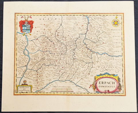
1646 Jan Jansson Antique Map Erbach Hesse & Baden-Württemberg Heidelberg Germany
- Title : Erpach Comitatus
- Ref #: 50182
- Size: 22in x 18in (560mm x 460mm)
- Date : 1646
- Condition: (A+) Fine Condition
Description:
This beautifully hand coloured original copper-plate engraved antique map of the Erbach im Odenwald area in the Baden-Württemberg & Hesse regions of southern Germany, framed by the Neckar River in the south, Rhine River to the west and the Main river to the east (major towns and cities of Heidelberg, Gensheim, Worms, Miltenberg and Oldenburg) by Jan Jansson was published in the 1646 Latin edition of Mercators Atlas by Jan Jansson and Henricus Hondius. (Ref: Tooley, Koeman)
General Definitions:
Paper thickness and quality: - Heavy and stable
Paper color : - off white
Age of map color: - Original
Colors used: - Yellow, green, blue, pink
General color appearance: - Authentic
Paper size: - 22in x 18in (560mm x 460mm)
Plate size: - 19in x 14 1/2in (480mm x 370mm)
Margins: - Min 2in (50mm)
Imperfections:
Margins: - None
Plate area: - None
Verso: - None
Background:
Erbach is a town and the district seat of the Odenwaldkreis (district) in Hesse, Germany.
Baden-Württemberg is a state in southwest Germany, east of the Rhine, which forms the border with France.
Hesseis a federal state (Land) of the Federal Republic of Germany
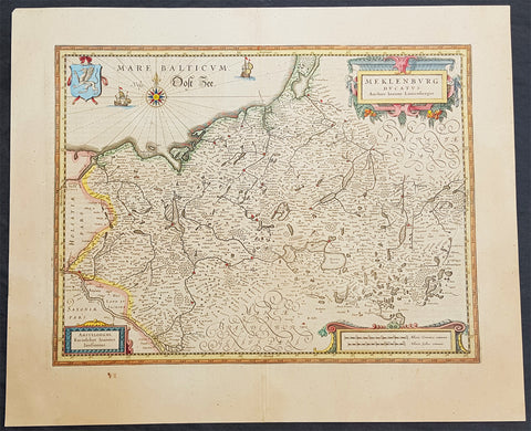
1646 Jan Jansson Antique Map of Mecklenburg NE Germany Rostock, Wizmar, Parchim
- Title : Meklenburg Ducatus
- Ref #: 50185
- Size: 11 1/2in x 8in (290mm x 205mm)
- Date : 1646
- Condition: (A+) Fine Condition
Description:
This beautifully hand coloured original copper-plate engraved antique map of the Mecklenburg, north eastern Germany by Jan Jansson was published in the 1646 Latin edition of Mercators Atlas by Jan Jansson and Henricus Hondius. (Ref: Tooley, Koeman)
General Definitions:
Paper thickness and quality: - Heavy and stable
Paper color : - off white
Age of map color: - Original
Colors used: - Yellow, green, blue, pink
General color appearance: - Authentic
Paper size: - 22in x 18in (560mm x 460mm)
Plate size: - 19in x 14 1/2in (480mm x 370mm)
Margins: - Min 2in (50mm)
Imperfections:
Margins: - None
Plate area: - None
Verso: - None
Background:
Mecklenburg is a historical region in northern Germany comprising the western and larger part of the federal-state Mecklenburg-Vorpommern. The largest cities of the region are Rostock, Schwerin, Neubrandenburg, Wismar and Güstrow.
The name Mecklenburg derives from a castle named Mikilenburg (Old Saxon: big castle, hence its translation into New Latin and Greek: Megalopolis), located between the cities of Schwerin and Wismar. In Slavic language it was known as Veligrad, which also means big castle. It was the ancestral seat of the House of Mecklenburg; for a time the area was divided into Mecklenburg-Schwerin and Mecklenburg-Strelitz among the same dynasty.
Linguistically Mecklenburgers retain and use many features of Low German vocabulary or phonology.
Mecklenburg is the site of many prehistoric dolmen tombs. Its earliest organised inhabitants may have had Celtic origins. By no later than 100 BC the area had been populated by pre-Christian Germanic peoples.
The traditional symbol of Mecklenburg, the grinning steers head (Low German: Ossenkopp, lit.: oxen\'s head, with osse being a synonym for steer and bull in Middle Low German), with an attached hide, and a crown above, may have originated from this period. It represents what early peoples would have worn, i.e. a steers\'s head as a helmet, with the hide hanging down the back to protect the neck from the sun, and overall as a way to instill fear in the enemy.
From the 7th through the 12th centuries, the area of Mecklenburg was taken over by Western Slavic peoples, most notably the Obotrites and other tribes that Frankish sources referred to as Wends. The 11th century founder of the Mecklenburgian dynasty of Dukes and later Grand Dukes, which lasted until 1918, was Nyklot of the Obotrites.
In the late 12th century, Henry the Lion, Duke of the Saxons, conquered the region, subjugated its local lords, and Christianized its people, in a precursor to the Northern Crusades. From 12th to 14th century, large numbers of Germans and Flemings settled the area (Ostsiedlung), importing German law and improved agricultural techniques. The Wends who survived all warfare and devastation of the centuries before, including invasions of and expeditions into Saxony, Denmark and Liutizic areas as well as internal conflicts, were assimilated in the centuries thereafter. However, elements of certain names and words used in Mecklenburg speak to the lingering Slavic influence. An example would be the city of Schwerin, which was originally called Zuarin in Slavic. Another example is the town of Bresegard, the \'gard\' portion of the town name deriving from the Slavic word \'grad\', meaning city or town.
Since the 12th century, the territory remained stable and relatively independent of its neighbours; one of the few German territories for which this is true. During the reformation the Duke in Schwerin would convert to Protestantism and so would follow the Duchy of Mecklenburg.
Like many German territories, Mecklenburg was sometimes partitioned and re-partitioned among different members of the ruling dynasty. In 1621 it was divided into the two duchies of Mecklenburg-Schwerin and Mecklenburg-Güstrow. With the extinction of the Güstrow line in 1701, the Güstrow lands were redivided, part going to the Duke of Mecklenburg-Schwerin, and part going to the new line of Mecklenburg-Strelitz.
In 1815, the two Mecklenburgian duchies were raised to Grand Duchies, the Grand Duchy of Mecklenburg-Schwerin and the Grand Duchy of Mecklenburg-Strelitz, and subsequently existed separately as such in Germany under enlightened but absolute rule (constitutions being granted on the eve of World War I) until the revolution of 1918. Life in Mecklenburg could be quite harsh. Practices such as having to ask for permission from the Grand Duke to get married, or having to apply for permission to emigrate, would linger late into the history of Mecklenburg (i.e. 1918), long after such practices had been abandoned in other German areas. Even as late as the later half of the 19th century the Grand Duke personally owned half of the countryside. The last Duke abdicated in 1918, as monarchies fell throughout Europe. The Duke\'s ruling house reigned in Mecklenburg uninterrupted (except for two years) from its incorporation into the Holy Roman Empire until 1918. From 1918 to 1933, the duchies were free states in the Weimar Republic.
Traditionally Mecklenburg has always been one of the poorer German areas, and later the poorer of the provinces, or Länder, within a unified Germany. The reasons for this may be varied, but one factor stands out: agriculturally the land is poor and can not produce at the same level as other parts of Germany. The two Mecklenburgs made attempts at being independent states after 1918, but eventually this failed as their dependence on the rest of the German lands became apparent.
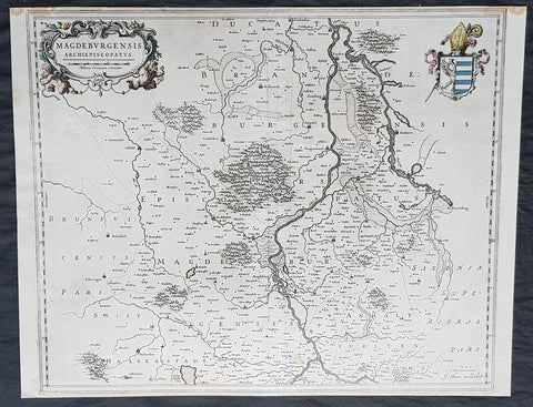
1650 Joan Blaeu Antique Map Archbishopic of Madenburg in Saxony-Anhalt, Germany
- Title : Magdeburgensis Archiepiscopatus...Amstelaedami J Blaeu excudebat
- Size: 21in x 17in (530mm x 430mm)
- Condition: (A+) Fine Condition
- Date : 1650
- Ref #: 70075
Description:
This beautifully hand coloured original copper-plate engraved antique map of the Archbishopric of Madenburg today located in the state of Saxony-Anhalt, Germany, on the Elbe River, was published in the 1650 edition of Joan Blaeus Atlas Novus.
General Definitions:
Paper thickness and quality: - Heavy and stable
Paper color : - off white
Age of map color: - Original
Colors used: - Yellow, Green, pink
General color appearance: - Authentic
Paper size: - 21in x 17in (530mm x 430mm)
Plate size: - 21in x 17in (530mm x 430mm)
Margins: - Min 1/4in (6mm)
Imperfections:
Margins: - Top margin cropped to plate-mark
Plate area: - None
Verso: - None
Background:
The Archbishopric of Magdeburg was a Roman Catholic archdiocese (969–1552) and Prince-Archbishopric (1180–1680) of the Holy Roman Empire centered on the city of Magdeburg on the Elbe River.
Planned since 955 and established in 968, the Roman Catholic archdiocese had de facto turned void since 1557, when the last papally confirmed prince-archbishop, the Lutheran Sigismund of Brandenburg came of age and ascended to the see and the Magdeburg cathedral chapter had adopted Lutheranism in 1567, with most parishioners having preceded in their conversion. All his successors were only administrators of the prince-archbishopric and Lutheran too, except of the Catholic layman Leopold William of Austria (1631–1635). In ecclesiastical respect the remaining Catholics and their parishes and abbeys in the former archdiocese were put under supervision of the Archdiocese of Cologne in 1648 and under the jurisdiction of the Apostolic Vicariate of the Northern Missions in 1670.
In political respect the Erzstift, the archiepiscopal and capitular temporalities, had gained imperial immediacy as prince-archbishopric in 1180. Its territory comprised only some parts of the archdiocesan area, such as the city of Magdeburg, the bulk of the Magdeburg Börde, and the Jerichow Land as an integral whole and exclaves comprising about the Saalkreis including Halle upon Saale, Oebisfelde and environs as well as Jüterbog and environs. The prince-archbishopric maintained its statehood as an elective monarchy until 1680. Then Brandenburg-Prussia acquired Magdeburg prince-archbishopric, and after being secularised, transformed it into the Duchy of Magdeburg, a hereditary monarchy in personal union with Brandenburg.
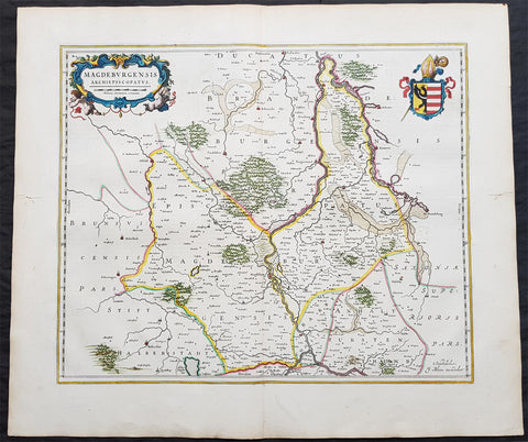
1650 Joan Blaeu Antique Map of Archbishopric of Madenburg Saxony-Anhalt, Germany
- Title : Magdeburgensis Archiepiscopatus
- Ref #: 40335
- Size: 24in x 21in (610mm x 535mm)
- Date : 1650
- Condition: (A+) Fine Condition
Description:
This beautifully hand coloured original copper-plate engraved antique map of the Archbishopric of Madenburg today located in the state of Saxony-Anhalt, Germany, on the Elbe River, was published in the 1650 Dutch edition of Joan Blaeus Atlas Novus.
General Definitions:
Paper thickness and quality: - Heavy and stable
Paper color : - off white
Age of map color: - Original
Colors used: - Blue, pink, red, green, yellow
General color appearance: - Authentic
Paper size: - 24in x 21in (610mm x 535mm)
Plate size: - 21in x 16 1/2in (535mm x 420mm)
Margins: - Min 1in (25mm)
Imperfections:
Margins: - Light age toning
Plate area: - None
Verso: - None
Background:
The Archbishopric of Magdeburg was a Roman Catholic archdiocese (969–1552) and Prince-Archbishopric (1180–1680) of the Holy Roman Empire centered on the city of Magdeburg on the Elbe River.
Planned since 955 and established in 968, the Roman Catholic archdiocese had de facto turned void since 1557, when the last papally confirmed prince-archbishop, the Lutheran Sigismund of Brandenburg came of age and ascended to the see and the Magdeburg cathedral chapter had adopted Lutheranism in 1567, with most parishioners having preceded in their conversion. All his successors were only administrators of the prince-archbishopric and Lutheran too, except of the Catholic layman Leopold William of Austria (1631–1635). In ecclesiastical respect the remaining Catholics and their parishes and abbeys in the former archdiocese were put under supervision of the Archdiocese of Cologne in 1648 and under the jurisdiction of the Apostolic Vicariate of the Northern Missions in 1670.
In political respect the Erzstift, the archiepiscopal and capitular temporalities, had gained imperial immediacy as prince-archbishopric in 1180. Its territory comprised only some parts of the archdiocesan area, such as the city of Magdeburg, the bulk of the Magdeburg Börde, and the Jerichow Land as an integral whole and exclaves comprising about the Saalkreis including Halle upon Saale, Oebisfelde and environs as well as Jüterbog and environs. The prince-archbishopric maintained its statehood as an elective monarchy until 1680. Then Brandenburg-Prussia acquired Magdeburg prince-archbishopric, and after being secularised, transformed it into the Duchy of Magdeburg, a hereditary monarchy in personal union with Brandenburg.
1650 Original Antique Hand Drawn Manuscript Map of Ptolemaic Germany - Unique
- Title : Germaniae Magnae Tabula ex mente Ptolemei
- Ref #: 50525
- Size: 19in x 12in (485mm x 305mm)
- Date : 1650
- Condition: (A+) Fine Condition
Description:
This is a unique and rare opportunity to acquire a hand drawn hand coloured manuscript Ptolemaic map of Germany.
The map was drawn from Ptolemy's map of Germany and is drawn on heavy cable laid paper with a Bunch of Grapes watermark, which denotes paper made in France in 1616. This does not necessarily mean the map was drawn in 1616 as paper was held for years sometimes before being used. But I would surmise from the colours, faded ink and age of the paper that the drawing was done sometime by the mid 17th century.
The map was once part of an atlas containing a range of 17th & 18th century maps with the margins being extended top and bottom to fit into the atlas.
Background of Ptolemy's Geographia: The first published edition of Ptolemy's ‘Geographia’ with maps, engraved by Taddeo Crivelli, was issued in Bologna in 1477. Unusually, this edition contained 26 maps, with one of the Asia maps divided up among three neighbouring sheets. With the exception of Palestine, these are the first regional maps of any of these various countries.
Unfortunately for the undertakers, this atlas seems not to have been a commercial success, and today only twenty-six examples of the atlas are recorded, with all but one in institutional libraries.
One explanation of the failure is that the publishers do not seem to have been fully mastered the intricacies and problems of engraving, and printing from, copper-plates, an art, which, after all, was very new and experimental. These problems were more successfully addressed by a German printer, Conrad Sweynheym, who was working on an edition of Ptolemy in Rome in the same period. Unfortunately, he did not live to see the volume appear, but his successor, Arnold Buckinck, saw the atlas through the press, in 1478.
The Rome Ptolemy contained 27 maps, with the same geographical coverage as the 1477 Ptolemy. Of the engraved editions of Ptolemy’s ‘Cosmographia’ the maps in the Rome edition are the finest fifteenth century examples, and second only to Mercator’s maps, from his 1578 edition. One explanation for this was the use of individual punches to stamp letters onto the printing plates, rather than engraving them. This allowed much greater uniformity than lettering-engravers were able to achieve, and gives a very pleasing overall effect. The atlas proved popular, and three successive editions (to 1508) followed, although only about forty examples of the first edition are recorded today.
Claudius Ptolemy(90 A.D.-168 A.D.) was a celebrated astronomer, mathematician, and geographer who lived in Alexandria in the 2nd century AD. Although his thinking influenced contemporary Arab geographers, little was known of his work in the West until manuscripts from Constantinople reached Italy in about 1400. These manuscripts were written in Greek and contained the names of every city, island, mountain and river known to the many travellers interviewed by Ptolemy. In addition, the latitude and longitude of each of the resulting eight thousand locations were also recorded. They were translated into Latin by 1401 and appeared in print by 1475. The earliest Byzantine manuscript maps, drawn by analysing the Ptolemy figures, date from the twelfth century. A number of hand-drawn copies were made in Italy throughout the early fifteenth century to accompany Ptolemy's text.
Ptolemy stressed the importance of accurate observations in order to calculate latitude and longitude, and laid down the principals of systematic cartography that remain to this day. Obviously there are many errors in Ptolemy's maps, due to the limited extent of basic geographic information at that time and the lack of a method of determining accurate longitudes. Judged by modern standards, the basic shortcoming of the Ptolemy world map is the small area it portrays. The Mediterranean is fairly well depicted, but is greatly exaggerated in length (Longitudinally). The effect of this, combined with Ptolemy's disregard for Eratosthenes' extremely accurate estimate of the earth's circumference (c. 200 B.C.) and the use of a Posidonius' much smaller flawed estimate (c.50 B.C.) implied a much shorter distance across that part of the unknown earth's surface not drawn on the map. Columbus and his contemporaries based their exploratory ventures on Ptolemy's calculations and, like him, had no idea of the vast New World to the west, interposed between Europe and Asia.
Work on the first “printed” atlas from the text of Ptolemy was started in 1473 and finally published in 1478. A crude copy of this atlas was produced and published by some dissident workers in 1477 in order to be ‘first’.However, the plates for the 1478 were done prior to the pirated issue and thus the 1478 atlas holds the title of the first Atlas of the world. There are very few surviving examples of this atlas and individual maps. (Ref: Stevenson; Tooley; M&B)
General Description:
Paper thickness and quality: - Heavy and stable
Paper color: - off white
Age of map color: - Original
Colors used: - Yellow, green, red.
General color appearance: - Authentic
Paper size: - 19in x 12in (485mm x 305mm)
Map size: - 13in x 11 1/2in (330mm x 295mm)
Margins: - Min 1/4in (6mm)
Imperfections:
Margins: - Top and bottom margin extended outside of image
Plate area: - None
Verso: - Light soiling
1662 Joan Blaeu Antique Map of Mansfeld Land, in SW Saxony-Anhalt, Germany
- Title : Mansfelda Comitatus Auctore Tilemanno Stella Sig.
- Ref #: 50180
- Size: 23 1/2in x 19 1/2in (600mm x 495mm)
- Date : 1662
- Condition: (A) Very Good Condition
Description:
This beautifully hand coloured original copper-plate engraved antique map of the ancient region of Mansfeld Land located in the in southwestern region of Saxony-Anhalt, Germany - centering on the city of Mansfeld - by was published in the 1662 Latin edition edition of Joan Blaeus Atlas Major.
General Definitions:
Paper thickness and quality: - Heavy and stable
Paper color : - off white
Age of map color: - Original
Colors used: - Blue, pink, red, green, yellow
General color appearance: - Authentic
Paper size: - 23 1/2in x 19 1/2in (600mm x 495mm)
Plate size: - 19 1/2in x 16 1/2in (495mm x 420mm)
Margins: - Min 1in (25mm)
Imperfections:
Margins: - Light age toning
Plate area: - Light age toning
Verso: - Light age toning
Background:
Mansfeld Land is a region in the southwestern corner of the German state of Saxony-Anhalt. The region derives its name from the counts of Mansfeld, who ruled this region for about 1,000 years.
The House of Mansfeld, whose members belonged to the Saxon nobility and served as counts in the Hassegau, was first documented in a 973 deed. The counts built Mansfeld Castle, whose foundations date back to the late 11th century, when one Hoyer of Mansfeld served as field marshal to Emperor Henry V. The first reference of the fortress coincides with the extinction of the elder line in 1229. The estates were inherited by the Lords of Querfurt, who also adopted the comital title, calling themselves Counts of Mansfeld from that time on.
The settlement of Mansfeld received town privileges in 1400, and grew through the development of copper and silver mining, an activity in which Hans Luder from Möhra, father to Martin Luther and Mansfeld citizen from 1484, was employed as a master smelter. Luthers family had arrived into a modest prosperity, he himself attended the local school between 1488 and 1496. The building known as Luther\'s School had to be torn down and rebuilt in 2000 due to structural problems. His parents house is preserved and today a museum. Luther also acted as an altar server at the St George parish church.
The Counts of Mansfeld had already lost Imperial immediacy in 1580. When the comital line finally became extinct in 1780, the estates around Mansfeld were incorporated into the Prussian Duchy of Magdeburg. The town retained the status of an independent city (Immediatstadt), it was temporarily part of the Napoleonic Kingdom of Westphalia and after the 1815 Congress of Vienna belonged to the Prussian Province of Saxony.
1662 Joan Blaeu Antique Map of Wołow County, Lower Silesia Voivodeship SW Poland
- Title : Ducatus Silesiae Wolanus Authore Jona Sculteto Sprotta Silesio
- Ref #: 93430
- Size: 24in x 20in (610mm x 510mm)
- Date : 1662
- Condition: (A) Very Good Condition
Description:
This beautifully hand coloured original copper-plate engraved antique, rare map of Wolow County, located at the time of publication in the Duchy of Głogow, in Lower Silesia, today SW Poland, was published in Joan Blaeu greatest publication, the first 1662 French edition of Atlas Major,.
As this map was only published over a 10 year period, as most of the plates were destroyed in the disasterous 1672 fire that wiped out the Blaeu publishing house, this map is extremely rare especially with original hand colour, such as this map.
General Definitions:
Paper thickness and quality: - Heavy and stable
Paper color : - off white
Age of map color: - Original
Colors used: - Yellow, green, blue, pink
General color appearance: - Authentic
Paper size: - 24in x 20in (610mm x 510mm)
Plate size: - 21in x 16 1/2in (535mm x 420mm)
Margins: - Min 1in (25mm)
Imperfections:
Margins: - Light soiling
Plate area: - Offsetting
Verso: - Offsetting
Background:
Wolow is a town in Lower Silesian Voivodeship in south-western Poland. It is the seat of Wołów County and Gmina Wołów. It lies approximately 38 kilometres north-west of the regional capital Wrocław.
The area around Wołów has been settled since prehistoric times. It became part of the emerging Polish state in the late 10th century under Mieszko I of Poland. The town was first mentioned in 1157 when a wooden castle founded by Senior Duke of Poland Władysław II the Exile is documented, which developed into a castle complex, which was again mentioned in 1202. Two villages developed near the castle, one of them called Wołowo. Probably in the second half of the 13th century the town was founded near Wołowo and partially on the soil of the second village. Wołów received Magdeburg town rights about 1285 at the time of German Ostsiedlung in the region; a Vogt is mentioned in 1288.
At that time Wołów belonged to the Duchy of Głogów, after 1312 to the Duchy of Oleśnica. With the duchy it came under the suzerainty of Bohemia in 1328. From 1473 dates the oldest known seal of the town, which already shows an ox, as do all later seals. Wołów was ruled by local Polish dukes until 1492, and soon after, in 1495, it came into the possession of the Czech Podiebrad family, then in 1517 it came into the hands the Hungarian magnate Johann Thurzó, before returning to Piast rule in 1523, by passing to the Duchy of Legnica. It remained there until the Piast dukes of Legnica-Brzeg-Wołów died out in 1675. As a result of the Thirty Years War, the towns population fell by half.
The Protestant Reformation was introduced to the town in 1522 by duke Frederick II. After the extinction of the local Piasts the duchy passed to the House of Habsburg, which opposed the Protestant denomination in the town, as part of the Counter-Reformation. In 1682 the towns parish church was closed and given to the Catholics. According to the Treaty of Altranstädt the church however was already returned to the Protestants in 1707 and stayed Protestant until 1945. The small Catholic minority in return received a Josephinian curacy.
In 1742 Wołów was annexed by Prussia. The duchy was divided into two districts and the town became county seat of one of the districts. The structure of the town was, until 1700, defined by craft, especially clothiers. As the seat of a duchy and a district administrative function however became more and more important. The industrialization played only a minor role and mostly affected smaller companies of the timber industry. In 1781 the city suffered a fire.
The town was part of Germany from 1871 to 1945. In January 1945 – just before town was taken by the Red Army – the Wehrmacht evacuated the German population westwards.
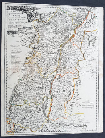
1666 Nicolas Sanson Large Antique Map of the Alsace Region of France & Germany
- Title : L Alsace ou Conquestes du Roy en Allemagne...G S Sanson...1666
- Size: 23in x 18in (585mm x 475mm)
- Condition: (A) Very Good Condition
- Date : 1666
- Ref #: 40631
Description:
This original copper-plate engraved antique map of the Alsace region of France & Germany - centering on the Rhine River - was engraved by Pierre Mariette in 1666 - dated - and was published by Nicholas Sanson in his atlas Cartes Generales de Toutes les Parties du Monde.
General Definitions:
Paper thickness and quality: - Heavy and stable
Paper color : - off white
Age of map color: - Original
Colors used: - Yellow, green, pink, orange
General color appearance: - Authentic
Paper size: - 23in x 18in (585mm x 475mm)
Plate size: - 20in x 17in (510mm x 415mm)
Margins: - Min 1/2in (12mm)
Imperfections:
Margins: - T&B margins cropped to borders
Plate area: - None
Verso: - Small restoration along centerfold
Background:
Alsace is a cultural and historical region in eastern France, on the west bank of the upper Rhine next to Germany and Switzerland.
In 1469, following the Treaty of St. Omer [fr], Upper Alsace was sold by Archduke Sigismund of Austria to Charles the Bold, Duke of Burgundy. Although Charles was the nominal landlord, taxes were paid to Frederick III, Holy Roman Emperor. The latter was able to use this tax and a dynastic marriage to his advantage to gain back full control of Upper Alsace (apart from the free towns, but including Belfort) in 1477 when it became part of the demesne of the Habsburg family, who were also rulers of the empire. The town of Mulhouse joined the Swiss Confederation in 1515, where it was to remain until 1798.
By the time of the Protestant Reformation in the 16th century, Strasbourg was a prosperous community, and its inhabitants accepted Protestantism in 1523. Martin Bucer was a prominent Protestant reformer in the region. His efforts were countered by the Roman Catholic Habsburgs who tried to eradicate heresy in Upper Alsace. As a result, Alsace was transformed into a mosaic of Catholic and Protestant territories. On the other hand, Mömpelgard (Montbéliard) to the southwest of Alsace, belonging to the Counts of Württemberg since 1397, remained a Protestant enclave in France until 1793.
This situation prevailed until 1639, when most of Alsace was conquered by France to keep it out of the hands of the Spanish Habsburgs, who by secret treaty in 1617 had gained a clear road to their valuable and rebellious possessions in the Spanish Netherlands, the Spanish Road. Beset by enemies and seeking to gain a free hand in Hungary, the Habsburgs sold their Sundgau territory (mostly in Upper Alsace) to France in 1646, which had occupied it, for the sum of 1.2 million Thalers. When hostilities were concluded in 1648 with the Treaty of Westphalia, most of Alsace was recognized as part of France, although some towns remained independent. The treaty stipulations regarding Alsace were complex. Although the French king gained sovereignty, existing rights and customs of the inhabitants were largely preserved. France continued to maintain its customs border along the Vosges mountains where it had been, leaving Alsace more economically oriented to neighbouring German-speaking lands. The German language remained in use in local administration, in schools, and at the (Lutheran) University of Strasbourg, which continued to draw students from other German-speaking lands. The 1685 Edict of Fontainebleau, by which the French king ordered the suppression of French Protestantism, was not applied in Alsace. France did endeavour to promote Catholicism. Strasbourg Cathedral, for example, which had been Lutheran from 1524 to 1681, was returned to the Catholic Church. However, compared to the rest of France, Alsace enjoyed a climate of religious tolerance.
France consolidated its hold with the 1679 Treaties of Nijmegen, which brought most remaining towns under its control. France seized Strasbourg in 1681 in an unprovoked action. These territorial changes were recognised in the 1697 Treaty of Ryswick that ended the War of the Grand Alliance.
The year 1789 brought the French Revolution and with it the first division of Alsace into the départements of Haut- and Bas-Rhin. Alsatians played an active role in the French Revolution. On 21 July 1789, after receiving news of the Storming of the Bastille in Paris, a crowd of people stormed the Strasbourg city hall, forcing the city administrators to flee and putting symbolically an end to the feudal system in Alsace. In 1792, Rouget de Lisle composed in Strasbourg the Revolutionary marching song La Marseillaise (as Marching song for the Army of the Rhine), which later became the anthem of France. La Marseillaise was played for the first time in April of that year in front of the mayor of Strasbourg Philippe-Frédéric de Dietrich. Some of the most famous generals of the French Revolution also came from Alsace, notably Kellermann, the victor of Valmy, Kléber, who led the armies of the French Republic in Vendée and Westermann, who also fought in the Vendée.
At the same time, some Alsatians were in opposition to the Jacobins and sympathetic to the restoration of the monarchy pursued by the invading forces of Austria and Prussia who sought to crush the nascent revolutionary republic. Many of the residents of the Sundgau made pilgrimages to places like Mariastein Abbey, near Basel, in Switzerland, for baptisms and weddings. When the French Revolutionary Army of the Rhine was victorious, tens of thousands fled east before it. When they were later permitted to return (in some cases not until 1799), it was often to find that their lands and homes had been confiscated. These conditions led to emigration by hundreds of families to newly vacant lands in the Russian Empire in 1803–4 and again in 1808. A poignant retelling of this event based on what Goethe had personally witnessed can be found in his long poem Hermann and Dorothea.
In response to the hundred day restoration of Napoleon I of France in 1815, Alsace along with other frontier provinces of France was occupied by foreign forces from 1815 to 1818, including over 280,000 soldiers and 90,000 horses in Bas-Rhin alone. This had grave effects on trade and the economy of the region since former overland trade routes were switched to newly opened Mediterranean and Atlantic seaports.
The population grew rapidly, from 800,000 in 1814 to 914,000 in 1830 and 1,067,000 in 1846. The combination of economic and demographic factors led to hunger, housing shortages and a lack of work for young people. Thus, it is not surprising that people left Alsace, not only for Paris – where the Alsatian community grew in numbers, with famous members such as Baron Haussmann – but also for more distant places like Russia and the Austrian Empire, to take advantage of the new opportunities offered there: Austria had conquered lands in Eastern Europe from the Ottoman Empire and offered generous terms to colonists as a way of consolidating its hold on the new territories. Many Alsatians also began to sail to the United States, settling in many areas from 1820 to 1850. In 1843 and 1844, sailing ships bringing immigrant families from Alsace arrived at the port of New York. Some settled in Texas and Illinois, many to farm or to seek success in commercial ventures: for example, the sailing ships Sully (in May 1843) and Iowa (in June 1844) brought families who set up homes in northern Illinois and northern Indiana. Some Alsatian immigrants were noted for their roles in 19th-century American economic development. Others ventured to Canada to settle in southwestern Ontario, notably Waterloo County.
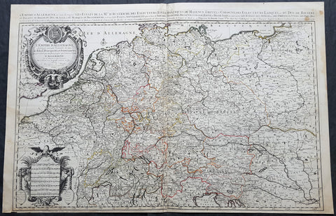
1692 Jaillot Large Antique Map of Allemagne or German Empire, Central Europe
- Title : L Empire D Allemagne distingue suivant l´etenedu de tous les estates principautes et souverainites...A Paris Chez...H Jaillot....1692
- Size: 37in x 24in (940mm x 615mm)
- Condition: (A+) Fine Condition
- Date : 1692
- Ref #: 16382
Description:
This very large, hand coloured original antique map of the German Empire and central Europe in the late 17th century by Alexis Hubert Jaillot - after Nicolas Sanson - was engraved in 1692 - the date is engraved in the dedication cartouche.
General Definitions:
Paper thickness and quality: - Heavy and stable
Paper color : - off white
Age of map color: - Original
Colors used: - Yellow, green, blue, pink
General color appearance: - Authentic
Paper size: - 37in x 24in (940mm x 615mm)
Plate size: - 36in x 23in (930mm x 605mm)
Margins: - Min 1/2in (12mm)
Imperfections:
Margins: - None
Plate area: - None
Verso: - None
Background:
The name Allemagne for Germany and the other similar-sounding names above are derived from the southern Germanic Alemanni, a Suebic tribe or confederation in todays Alsace, parts of Baden-Württemberg and Switzerland.
In 800, the Frankish king Charlemagne was crowned emperor and founded the Carolingian Empire, which was later divided in 843 among his heirs. Following the break up of the Frankish Realm, for 900 years, the history of Germany was intertwined with the history of the Holy Roman Empire, which subsequently emerged from the eastern portion of Charlemagnes original empire. The territory initially known as East Francia stretched from the Rhine in the west to the Elbe River in the east and from the North Sea to the Alps. The Ottonian rulers (919–1024) consolidated several major duchies and the German king Otto I was crowned Holy Roman Emperor of these regions in 962. In 996 Gregory V became the first German Pope, appointed by his cousin Otto III, whom he shortly after crowned Holy Roman Emperor. The Holy Roman Empire absorbed northern Italy and Burgundy under the reign of the Salian emperors (1024–1125), although the emperors lost power through the Investiture controversy.
In the 12th century, under the Hohenstaufen emperors (1138–1254), German princes increased their influence further south and east into territories inhabited by Slavs; they encouraged German settlement in these areas, called the eastern settlement movement (Ostsiedlung). Members of the Hanseatic League, which included mostly north German cities and towns, prospered in the expansion of trade. In the south, the Greater Ravensburg Trade Corporation (Große Ravensburger Handelsgesellschaft) served a similar function. The edict of the Golden Bull issued in 1356 by Emperor Charles IV provided the basic constitutional structure of the Empire and codified the election of the emperor by seven prince-electors who ruled some of the most powerful principalities and archbishoprics.
Population declined in the first half of the 14th century, starting with the Great Famine in 1315, followed by the Black Death of 1348–50. Despite the decline, however, German artists, engineers, and scientists developed a wide array of techniques similar to those used by the Italian artists and designers of the time who flourished in such merchant city-states as Venice, Florence and Genoa. Artistic and cultural centres throughout the German states produced such artists as the Augsburg painters Hans Holbein and his son, and Albrecht Dürer. Johannes Gutenberg introduced moveable-type printing to Europe, a development that laid the basis for the spread of learning to the masses.
In 1517, the Wittenberg priest Martin Luther nailed the Ninety-Five Theses to the church door, challenging the practice of selling of indulgences. He was subsequently excommunicated in the papal bull Exsurge Domine in 1520, and his followers were condemned in the 1521 Diet of Worms, which divided Western Christianity. In 1555, the Peace of Augsburg tolerated the Evangelical faith (now called Lutheranism) as an acceptable alternative to Catholicism, but also decreed that the faith of the prince was to be the faith of his subjects, a principle called cuius regio, eius religio. The agreement at Augsburg failed to address other religious creed: for example, the Reformed faith was still considered a heresy and the principle did not address the possible conversion of an ecclesiastic ruler, such as happened in Electorate of Cologne in 1583. However, in practice Calvinists were given protection under the Augsburg Confession Variata modified upon request by Philip Melanchthon.
From the Cologne War until the end of the Thirty Years Wars (1618–1648), religious conflict devastated German lands. The latter reduced the overall population of the German states by about 30 per cent, and in some places, up to 80 per cent. The Peace of Westphalia ended religious warfare among the Imperial Estates of the Holy Roman Empire. Their mostly German-speaking rulers were able to choose either Roman Catholicism, Lutheranism, or the Reformed faith as their official religion after 1648.
In the 18th century, the Holy Roman Empire consisted of approximately 1,800 territories. The elaborate legal system initiated by a series of Imperial Reforms (approximately 1450–1555) created the Imperial Estates and provided for considerable local autonomy among ecclesiastical, secular, and hereditary states, reflected in the Imperial Diet. The House of Habsburg held the imperial crown from 1438 until the death of Charles VI in 1740. Having no male heirs, he had convinced the Electors to retain Habsburg hegemony in the office of the emperor by agreeing to the Pragmatic Sanction of 1713. This was finally settled through the War of Austrian Succession; in the Treaty of Aix-la-Chapelle, Charles VIs daughter Maria Theresa ruled the Empire as Empress Consort when her husband, Francis I, became Holy Roman Emperor. From 1740, the dualism between the Austrian Habsburg Monarchy and the Kingdom of Prussia dominated the German history.
In 1772, then again in 1793 and 1795, the two dominant German states of Prussia and Austria, along with the Russian Empire, agreed to the Partitions of Poland; dividing among themselves the lands of the Polish–Lithuanian Commonwealth. As a result of the partitions, millions of Polish speaking inhabitants fell under the rule of the two German monarchies. However, the annexed territories though incorporated into the Kingdom of Prussia and the Habsburg Realm, were not legally considered as a part of the Holy Roman Empire. During the period of the French Revolutionary Wars, along with the arrival of the Napoleonic era and the subsequent final meeting of the Imperial Diet, most of the secular Free Imperial Cities were annexed by dynastic territories; the ecclesiastical territories were secularised and annexed. In 1806 the Imperium was dissolved; many German states, particularly the Rhineland states, fell under the influence of France. Until 1815, France, Russia, Prussia and the Habsburgs (Austria) competed for hegemony in the German states during the Napoleonic Wars.
Following the fall of Napoleon, the Congress of Vienna (convened in 1814) founded the German Confederation (Deutscher Bund), a loose league of 39 sovereign states. The appointment of the Emperor of Austria as the permanent president of the Confederation reflected the Congresss failure to accept Prussias rising influence among the German states, and acerbated the long-standing competition between the Hohenzollern and Habsburg interests. Disagreement within restoration politics partly led to the rise of liberal movements, followed by new measures of repression by Austrian statesman Metternich. The Zollverein, a tariff union, furthered economic unity in the German states.
National and liberal ideals of the French Revolution gained increasing support among many, especially young, Germans. The Hambach Festival in May 1832 was a main event in support of German unity, freedom and democracy. In the light of a series of revolutionary movements in Europe, which established a republic in France, intellectuals and commoners started the Revolutions of 1848 in the German states. King Frederick William IV of Prussia was offered the title of Emperor, but with a loss of power; he rejected the crown and the proposed constitution, leading to a temporary setback for the movement.
Foundation of the German Empire in Versailles, 1871. Bismarck is at the centre in a white uniform.
King William I appointed Otto von Bismarck as the new Minister President of Prussia in 1862. Bismarck successfully concluded war on Denmark in 1864, which promoted German over Danish interests in the Jutland peninsula. The subsequent (and decisive) Prussian victory in the Austro-Prussian War of 1866 enabled him to create the North German Confederation (Norddeutscher Bund) which excluded Austria from the federations affairs. After the French defeat in the Franco-Prussian War, the German princes proclaimed the founding of the German Empire in 1871 at Versailles, uniting all the scattered parts of Germany except Austria and the German-speaking parts of Switzerland. Prussia was the dominant constituent state of the new empire; the Hohenzollern King of Prussia ruled as its concurrent Emperor, and Berlin became its capital.
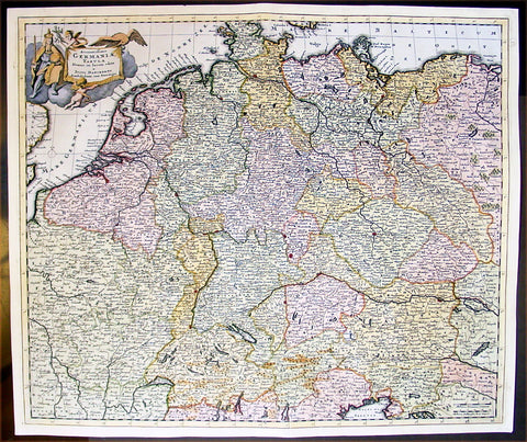
1699 Danckerts Antique Map of Germany & Central Europe Poland to France to Italy
- Title : Accuratissima Germaniae Tabula
- Ref #: 16295
- Size: 24in x 20 1/2in (610mm x 520mm)
- Date : 1699
- Condition: (A+) Fine Condition
Description:
This large beautifully hand coloured original antique map of central Europe - centering on the various German States but stretching from Poland in the east to France in the west and Venice to the south - by Justus Danckerts was published in 1699.
In the latter half of the fifteenth century Germany, though nominally still part of the Holy Roman Empire, was a fragmented land, split into a score of principalities and Imperial Cities, fiercely jealous of each other but having in common an extraordinary creative urge which produced builders of great churches and cathedrals, workers in stone and wood, metal engravers, painters and makers of scientific instruments, who were the envy of the world. Of all their achievements, the invention of movable-type printing was to have the most profound effect on human relationships. Printing industries soon grew up in many cities, including Nuremberg and Augsburg where wood engraving already flourished and which, with Basle and Strassburg, were also the centres of geographical knowledge. Not only were local and regional maps produced in considerable variety and quantity, but more particularly the geographers and mathematicians of Nuremberg are famous for their globes of the world, some of which are still preserved.
The most important map of the whole of Germany produced in this period was a manuscript dated c. 1464 by Nicholas Cusanus (Khryfts), Cardinal, humanist and scholar, friend of Toscanelli, the Italian geographer, and one of the most brilliant men of his day. The map covering Germany, Southern Scandinavia and the Baltic was printed in 1491, long after the author's death, and it served as a model for a similar map in the Nuremberg Chronicle. We have written in some detail in Chapter 4 of this famous book, first published in 1493, which contained a great number of woodcut views and maps, but as far as cartography is concerned the printing of Ptolemy's Geographia at Ulm in 1482 (and 1486) - the first edition with woodcut maps - was an event of the greatest importance. The most ambitious editions of the Ptolemy maps appeared in 1513 in Strassburg, containing not only maps of the ancient world but also twenty new ones, including one of the 'New World', based on the latest contemporary.
knowledge. This was produced under the guidance of Martin Waldseemuller, a German cartographer, at St Die' in Lorraine, at that time a noted centre of learning. Other editions followed in the years up to 1 541, overlapping with the newer work of Sebastian Mu'~nster, an eminent mathematician and linguist, who settled in Basle and whose prolific output of atlases and maps contained also many plans and views of the great cities of the time. These in turn were superseded by Braun and Hogenberg's Civitates Orbis Terrarumissued in Cologne between the years 1572 and 1618, which was one of the most famous publications of the period.
In the seventeenth century Dutch supremacy in map making and publishing overshadowed Germany no less than England and France and there was to be no revival until the foundation in Nuremberg about the year 1700 of the printing firm of J. B. Homann, whose business acumen started a resurgence of map publishing. He became a member of the Berlin Academy of Sciences and was appointed Geographer to the Emperor in 1715. The business was continued by his son, Johann Christoph, and was eventually bequeathed to the founder's son-in-law on condition that he continued the business under the name of Homann Heirs. Other notable publishing houses active during the century were run by Matthaus Seutter and Tobias Lotter in the rival city of Augsburg. (Ref: Tooley; M&B)
General Description:
Paper thickness and quality: - Heavy and stable
Paper color: - off white
Age of map color: - Early
Colors used: - Yellow, green, red, brown.
General color appearance: - Authentic and fresh
Paper size: - 24in x 20 1/2in (610mm x 520mm)
Plate size: - 23in x 19 1/2in (585mm x 495mm)
Margins: - Min 1/2in (10mm)
Imperfections:
Margins: - None
Plate area: - None
Verso: - Bottom centerfold re-joined, no loss.

1710 John Senex Large Antique Map of Germany, Central Europe, Baltic to Austria
- Title : Germany Corrected from the Observations of the Royal Society at London and the Royal Academy at Paris by John Senex FRS....1710
- Size: 41in x 26 1/2in (1.040m x 660mm)
- Condition: (A) Very Good Condition
- Date : 1710
- Ref #: 24906
Description:
This large hand coloured original antique map of Germany was engraved by John Senex in 1710 - dated - and was published in Senex Elephant Folio Atlas.
This map is in VG condition, with these large scale maps being scarce due mainly to their size with damage and loss over time inevitable.
General Definitions:
Paper thickness and quality: - Heavy and stable
Paper color : - off white
Age of map color: - Original
Colors used: - Yellow, green, blue, pink
General color appearance: - Authentic
Paper size: - 41in x 26 1/2in (1.040m x 660mm)
Plate size: - 40in x 26in (1.00m x 650mm)
Margins: - Min 1/2in (12mm)
Imperfections:
Margins: - Chipping to bottom margin
Plate area: - Age toning along centerfold, light creasing
Verso: - Light creasing.
Background:
Because of Germanys long history as a non-united region of distinct tribes and states before January 1871, there are many widely varying names of Germany in different languages, perhaps more so than for any other European nation. For example, in the German language, the country is known as Deutschland, in Spanish as Alemania, in French as Allemagne, in Italian as Germania (although Germans are called tedeschi), in Polish as Niemcy, and in Finnish as Saksa.
In 800, the Frankish king Charlemagne was crowned emperor and founded the Carolingian Empire, which was later divided in 843 among his heirs. Following the break up of the Frankish Realm, for 900 years, the history of Germany was intertwined with the history of the Holy Roman Empire, which subsequently emerged from the eastern portion of Charlemagnes original empire. The territory initially known as East Francia stretched from the Rhine in the west to the Elbe River in the east and from the North Sea to the Alps. The Ottonian rulers (919–1024) consolidated several major duchies and the German king Otto I was crowned Holy Roman Emperor of these regions in 962. In 996 Gregory V became the first German Pope, appointed by his cousin Otto III, whom he shortly after crowned Holy Roman Emperor. The Holy Roman Empire absorbed northern Italy and Burgundy under the reign of the Salian emperors (1024–1125), although the emperors lost power through the Investiture controversy.
In the 12th century, under the Hohenstaufen emperors (1138–1254), German princes increased their influence further south and east into territories inhabited by Slavs; they encouraged German settlement in these areas, called the eastern settlement movement (Ostsiedlung). Members of the Hanseatic League, which included mostly north German cities and towns, prospered in the expansion of trade. In the south, the Greater Ravensburg Trade Corporation (Große Ravensburger Handelsgesellschaft) served a similar function. The edict of the Golden Bull issued in 1356 by Emperor Charles IV provided the basic constitutional structure of the Empire and codified the election of the emperor by seven prince-electors who ruled some of the most powerful principalities and archbishoprics.
Population declined in the first half of the 14th century, starting with the Great Famine in 1315, followed by the Black Death of 1348–50. Despite the decline, however, German artists, engineers, and scientists developed a wide array of techniques similar to those used by the Italian artists and designers of the time who flourished in such merchant city-states as Venice, Florence and Genoa. Artistic and cultural centres throughout the German states produced such artists as the Augsburg painters Hans Holbein and his son, and Albrecht Dürer. Johannes Gutenberg introduced moveable-type printing to Europe, a development that laid the basis for the spread of learning to the masses.
In 1517, the Wittenberg priest Martin Luther nailed the Ninety-Five Theses to the church door, challenging the practice of selling of indulgences. He was subsequently excommunicated in the papal bull Exsurge Domine in 1520, and his followers were condemned in the 1521 Diet of Worms, which divided Western Christianity. In 1555, the Peace of Augsburg tolerated the Evangelical faith (now called Lutheranism) as an acceptable alternative to Catholicism, but also decreed that the faith of the prince was to be the faith of his subjects, a principle called cuius regio, eius religio. The agreement at Augsburg failed to address other religious creed: for example, the Reformed faith was still considered a heresy and the principle did not address the possible conversion of an ecclesiastic ruler, such as happened in Electorate of Cologne in 1583. However, in practice Calvinists were given protection under the Augsburg Confession Variata modified upon request by Philip Melanchthon.
From the Cologne War until the end of the Thirty Years Wars (1618–1648), religious conflict devastated German lands. The latter reduced the overall population of the German states by about 30 per cent, and in some places, up to 80 per cent. The Peace of Westphalia ended religious warfare among the Imperial Estates of the Holy Roman Empire. Their mostly German-speaking rulers were able to choose either Roman Catholicism, Lutheranism, or the Reformed faith as their official religion after 1648.
In the 18th century, the Holy Roman Empire consisted of approximately 1,800 territories. The elaborate legal system initiated by a series of Imperial Reforms (approximately 1450–1555) created the Imperial Estates and provided for considerable local autonomy among ecclesiastical, secular, and hereditary states, reflected in the Imperial Diet. The House of Habsburg held the imperial crown from 1438 until the death of Charles VI in 1740. Having no male heirs, he had convinced the Electors to retain Habsburg hegemony in the office of the emperor by agreeing to the Pragmatic Sanction of 1713. This was finally settled through the War of Austrian Succession; in the Treaty of Aix-la-Chapelle, Charles VIs daughter Maria Theresa ruled the Empire as Empress Consort when her husband, Francis I, became Holy Roman Emperor. From 1740, the dualism between the Austrian Habsburg Monarchy and the Kingdom of Prussia dominated the German history.
In 1772, then again in 1793 and 1795, the two dominant German states of Prussia and Austria, along with the Russian Empire, agreed to the Partitions of Poland; dividing among themselves the lands of the Polish–Lithuanian Commonwealth. As a result of the partitions, millions of Polish speaking inhabitants fell under the rule of the two German monarchies. However, the annexed territories though incorporated into the Kingdom of Prussia and the Habsburg Realm, were not legally considered as a part of the Holy Roman Empire. During the period of the French Revolutionary Wars, along with the arrival of the Napoleonic era and the subsequent final meeting of the Imperial Diet, most of the secular Free Imperial Cities were annexed by dynastic territories; the ecclesiastical territories were secularised and annexed. In 1806 the Imperium was dissolved; many German states, particularly the Rhineland states, fell under the influence of France. Until 1815, France, Russia, Prussia and the Habsburgs (Austria) competed for hegemony in the German states during the Napoleonic Wars.
Following the fall of Napoleon, the Congress of Vienna (convened in 1814) founded the German Confederation (Deutscher Bund), a loose league of 39 sovereign states. The appointment of the Emperor of Austria as the permanent president of the Confederation reflected the Congresss failure to accept Prussias rising influence among the German states, and acerbated the long-standing competition between the Hohenzollern and Habsburg interests. Disagreement within restoration politics partly led to the rise of liberal movements, followed by new measures of repression by Austrian statesman Metternich. The Zollverein, a tariff union, furthered economic unity in the German states.
National and liberal ideals of the French Revolution gained increasing support among many, especially young, Germans. The Hambach Festival in May 1832 was a main event in support of German unity, freedom and democracy. In the light of a series of revolutionary movements in Europe, which established a republic in France, intellectuals and commoners started the Revolutions of 1848 in the German states. King Frederick William IV of Prussia was offered the title of Emperor, but with a loss of power; he rejected the crown and the proposed constitution, leading to a temporary setback for the movement.
Foundation of the German Empire in Versailles, 1871. Bismarck is at the centre in a white uniform.
King William I appointed Otto von Bismarck as the new Minister President of Prussia in 1862. Bismarck successfully concluded war on Denmark in 1864, which promoted German over Danish interests in the Jutland peninsula. The subsequent (and decisive) Prussian victory in the Austro-Prussian War of 1866 enabled him to create the North German Confederation (Norddeutscher Bund) which excluded Austria from the federations affairs. After the French defeat in the Franco-Prussian War, the German princes proclaimed the founding of the German Empire in 1871 at Versailles, uniting all the scattered parts of Germany except Austria and the German-speaking parts of Switzerland. Prussia was the dominant constituent state of the new empire; the Hohenzollern King of Prussia ruled as its concurrent Emperor, and Berlin became its capital.
In the Gründerzeit period following the unification of Germany, Bismarcks foreign policy as Chancellor of Germany under Emperor William I secured Germanys position as a great nation by forging alliances, isolating France by diplomatic means, and avoiding war. Under Wilhelm II, Germany, like other European powers, took an imperialistic course, leading to friction with neighbouring countries. Most alliances in which Germany had previously been involved were not renewed. This resulted in the creation of a dual alliance with the multinational realm of Austria-Hungary, promoting at least benevolent neutrality if not outright military support. Subsequently, the Triple Alliance of 1882 included Italy, completing a Central European geographic alliance that illustrated German, Austrian and Italian fears of incursions against them by France and/or Russia. Similarly, Britain, France and Russia also concluded alliances that would protect them against Habsburg interference with Russian interests in the Balkans or German interference against France.
At the Berlin Conference in 1884, Germany claimed several colonies including German East Africa, German South West Africa, Togoland, and Kamerun. Later, Germany further expanded its colonial empire to include German New Guinea, German Micronesia and German Samoa in the Pacific, and Kiautschou Bay in China. In what became known as the First Genocide of the Twentieth-Century, between 1904 and 1907, the German colonial government in South West Africa (present-day Namibia) ordered the annihilation of the local Herero and Namaqua peoples, as a punitive measure for an uprising against German colonial rule. In total, around 100,000 people—80% of the Herero and 50% of the Namaqua—perished from imprisonment in concentration camps, where the majority died of disease, abuse, and exhaustion, or from dehydration and starvation in the countryside after being deprived of food and water.
The assassination of Austrias crown prince on 28 June 1914 provided the pretext for the Austrian Empire to attack Serbia and trigger World War I. After four years of warfare, in which approximately two million German soldiers were killed, a general armistice ended the fighting on 11 November, and German troops returned home. In the German Revolution (November 1918), Emperor Wilhelm II and all German ruling princes abdicated their positions and responsibilities. Germanys new political leadership signed the Treaty of Versailles in 1919. In this treaty, Germany, as part of the Central Powers, accepted defeat by the Allies in one of the bloodiest conflicts of all time. Germans perceived the treaty as humiliating and unjust and it was later seen by historians as influential in the rise of Adolf Hitler. After the defeat in the First World War, Germany lost around 13% of its European territory (areas predominantly inhabited by ethnic Polish, French and Danish populations, which were lost following the Greater Poland Uprising, the return of Alsace-Lorraine and the Schleswig plebiscites), and all of its colonial possessions in Africa and the South Sea.
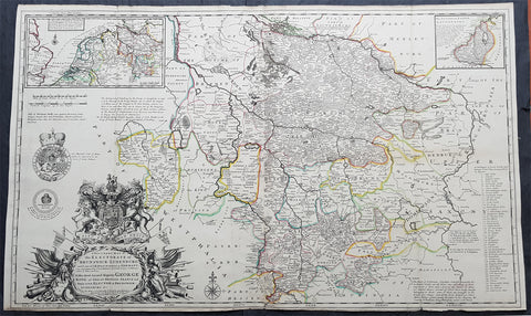
1720 Moll Large Antique Map Brunswick Luneburg, NW Germany - Dedicated to George I
- Title : A New & Exact Map of the Electorate of Brunswick-Lunenburg and ye rest of ye Kings Dominions in Germany, very much Improved by ye kind Assistance of severall Curious Gentlemen . . . To His Most Sacred Majesty George King of Great Britain, France and Ireland, Elector of Brunswick-Lunenburg &c
- Size: 41in x 24 1/2in (1.015m x 620mm)
- Condition: (A+) Fine Condition
- Date : 1720
- Ref #: 93043
Description:
This very large beautifully hand coloured original superbly executed copper-plate engraved antique map of the Electorate of Brunswick Luneburg in NW Germany, by Herman Moll, was published in 1720 in the atlas The World Described, or a New and Correct Sett of Maps by John Bowles, Thomas Bowles, Philip Overton & John King of London.
In the 18th century many large-scale maps were published by the likes of John Senex and Herman Moll, this trend continued until the end of private mapping in the early 19th century when it was replaced by Ordnance Survey maps.
General Definitions:
Paper thickness and quality: - Heavy and stable
Paper color : - off white
Age of map color: - Original
Colors used: - Yellow, green, blue, pink
General color appearance: - Authentic
Paper size: - 41in x 24 1/2in (1.015m x 620mm)
Plate size: - 41in x 24 1/2in (1.015m x 620mm)
Margins: - Min 1/2in (12mm)
Imperfections:
Margins: - Age toning along top margin
Plate area: - Folds as issued
Verso: - Backed onto original haevy paper
Background:
Fine decorative map of Brunswick-Lunenburg and environs, dedicated to King George I, of Great Britain, who was also an Elector of the Holy Roman Empire, and Ruler of the Duchy and Electorate of Brunswick-Luneburg.
At top center is the estuarial northern part of the Elbe River facing Hamburg, while Hanover appears near the center of the map.
Molls depiction of the royal arms and other embellishments surrounding the cartouche display his considerable engraving talents.
Published shortly after King George I ascendancy to the throne as King of England, in 1714, the map marks one of the more fascinating chapters in British History and a turning point in the history and power structure of the British Monarchy.
The Inset maps show:
1. Part of England
2. Netherlands
3. Part of Germany (showing route of the King from Hannover to Greenwich)
4. Duchy of Saxon Lauwenburg
King George I
George I (1660 - 1727), was King of Great Britain and Ireland from August 1, 1714, until his death, and ruler of the Duchy and Electorate of Brunswick-Lüneburg (Hanover) in the Holy Roman Empire, from 1698.
George was born in Hanover and inherited the titles and lands of the Duchy of Brunswick-Lüneburg from his father and uncles. A succession of European wars expanded his German domains during his lifetime and in 1708 he was ratified as prince-elector of Hanover.
At the age of 54, after the death of Queen Anne of Great Britain, George ascended the British throne as the first monarch of the House of Hanover. Although over fifty Roman Catholics bore closer blood relationships to Anne, the Act of Settlement 1701 prohibited Catholics from inheriting the British throne.
George was Anne\'s closest living Protestant relative. In reaction, Jacobites attempted to depose George and replace him with Anne\'s Catholic half-brother, James Francis Edward Stuart, but their attempts failed.
During George\'s reign, the powers of the monarchy diminished and Britain began a transition to the modern system of cabinet government, led by a prime minister. Towards the end of his reign, actual power was held by Sir Robert Walpole, now recognized as Britain\'s first de facto prime minister.
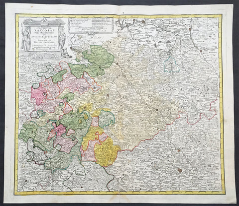
1735 J B Homann Large Antique Map of Old Saxony, Germany - Berlin to Prague
- Title : Circuli Super Saxoniae pars Meridionalis sive Ducatus...Homannianos
- Date : 1735
- Condition: (A+) Fine Condition
- Ref # : 30832
- Size : 23in x 19in (600mm x 520mm)
Description:
This large original hand coloured copper plate engraved antique map of the Saxony region of central Germany. The map stretches from Berlin in the north to Prague in the Czech Republic to the south, by J B Homann was published by the Homann Heirs firm in 1735. (Ref: Tooley; M&B)
General Definitions:
Paper thickness and quality: - Heavy and stable
Paper color : - off white
Age of map color: - Original
Colors used: - Blue, pink, red, green, yellow
General color appearance: - Authentic
Paper size: - 23in x 19in (600mm x 520mm)
Plate size: - 24in x 19 1/2in (565mm x 495mm)
Margins: - Min 1in (25mm)
Imperfections:
Margins: - None
Plate area: - None
Verso: - None
Background:
Saxony is a landlocked federal state of Germany, bordering the federal states of Brandenburg, Saxony Anhalt, Thuringia, and Bavaria, as well as the countries of Poland and the Czech Republic.
The history of the state of Saxony spans more than a millennium. It has been a medieval duchy, an electorate of the Holy Roman Empire, a kingdom, and twice a republic.
The area of the modern state of Saxony should not be confused with Old Saxony, the area inhabited by Saxons. Old Saxony corresponds roughly to the modern German states of Lower Saxony, Saxony-Anhalt, and the Westphalian part of North Rhine-Westphalia.
The territory of the Free State of Saxony became part of the Holy Roman Empire by the 10th century, when the dukes of Saxony were also kings (or emperors) of the Holy Roman Empire, comprising the Ottonian, or Saxon, Dynasty. Around this time, the Billungs, a Saxon noble family, received extensive fields in Saxony. The emperor eventually gave them the title of dukes of Saxony. After Duke Magnus died in 1106, causing the extinction of the male line of Billungs, oversight of the duchy was given to Lothar of Supplinburg, who also became emperor for a short time.
In 1137, control of Saxony passed to the Guelph dynasty, descendants of Wulfhild Billung, eldest daughter of the last Billung duke, and the daughter of Lothar of Supplinburg. In 1180 large portions west of the Weser were ceded to the Bishops of Cologne, while some central parts between the Weser and the Elbe remained with the Guelphs, becoming later the Duchy of Brunswick-Lüneburg. The remaining eastern lands, together with the title of Duke of Saxony, passed to an Ascanian dynasty (descended from Eilika Billung, Wulfhild\\\\\\\'s younger sister) and were divided in 1260 into the two small states of Saxe-Lauenburg and Saxe-Wittenberg. The former state was also named Lower Saxony, the latter Upper Saxony, thence the later names of the two Imperial Circles Saxe-Lauenburg and Saxe-Wittenberg. Both claimed the Saxon electoral privilege for themselves, but the Golden Bull of 1356 accepted only Wittenberg\\\\\\\'s claim, with Lauenburg nevertheless continuing to maintain its claim. In 1422, when the Saxon electoral line of the Ascanians became extinct, the Ascanian Eric V of Saxe-Lauenburg tried to reunite the Saxon duchies.
However, Sigismund, King of the Romans, had already granted Margrave Frederick IV the Warlike of Meissen (House of Wettin) an expectancy of the Saxon electorate in order to remunerate his military support. On 1 August 1425 Sigismund enfeoffed the Wettinian Frederick as Prince-Elector of Saxony, despite the protests of Eric V. Thus the Saxon territories remained permanently separated. The Electorate of Saxony was then merged with the much bigger Wettinian Margraviate of Meissen, however using the higher-ranking name Electorate of Saxony and even the Ascanian coat-of-arms for the entire monarchy. Thus Saxony came to include Dresden and Meissen. In the 18th and 19th centuries Saxe-Lauenburg was colloquially called the Duchy of Lauenburg, which in 1876 merged with Prussia as the Duchy of Lauenburg district.
Saxony-Wittenberg, in modern Saxony-Anhalt, became subject to the margravate of Meissen, ruled by the Wettin dynasty in 1423. This established a new and powerful state, occupying large portions of the present Free State of Saxony, Thuringia, Saxony-Anhalt and Bavaria (Coburg and its environs). Although the centre of this state was far to the southeast of the former Saxony, it came to be referred to as Upper Saxony and then simply Saxony, while the former Saxon territories were now known as Lower Saxony.
In 1485, Saxony was split. A collateral line of the Wettin princes received what later became Thuringia and founded several small states there (see Ernestine duchies). The remaining Saxon state became still more powerful and was known in the 18th century for its cultural achievements, although it was politically weaker than Prussia and Austria, states which oppressed Saxony from the north and south, respectively.
Between 1697 and 1763, the Electors of Saxony were also elected Kings of Poland in personal union.
In 1756, Saxony joined a coalition of Austria, France and Russia against Prussia. Frederick II of Prussia chose to attack preemptively and invaded Saxony in August 1756, precipitating the Third Silesian War (part of the Seven Years\\\\\\\' War). The Prussians quickly defeated Saxony and incorporated the Saxon army into the Prussian army. At the end of the Seven Years\\\\\\\' War, Saxony recovered its independence in the 1763 Treaty of Hubertusburg.
1735 Schubler & Steidlin Antique Baroque Print Musical Ball Regensburg Ger. 1717
- Title : Bal, welche den 26. Sept: 1717 in Sr Durchl: Eminens des Herrn Cardinals residens zu Regensburg, in dem so genamten Lowen-Saal, gehalten worden....NB das Bal Zimmer war mit rohten Tuch belegt
- Ref #: 93443
- Size: 19in x 13 1/2in (490mm x 345mm)
- Date : 1735
- Condition: (A) Very Good Condition
Description:
This large original Baroque copper plate engraved antique print, numbered three of three, of an early 18th century Ball, part of the celebrations at the Royal Court in the Cardinal Castle of Regensburg, on September 26, 1717, by Johann Schubler, was engraved by Johann Matthias Steidlin or Steudlin 1717-1754 and published by the Jeremias Wolff Erben in 1735.
A wonderful piece of Baroque art, engraved and published by some of the foremost art engravers and publishers at the beginning of the 18th century.
Professionally matted and can be easily removed if required.
General Definitions:
Paper thickness and quality: - Heavy and stable
Paper color : - off white
Age of map color: -
Colors used: -
General color appearance: -
Paper size: - 19in x 13 1/2in (490mm x 345mm)
Plate size: - 19in x 13 1/2in (490mm x 345mm)
Margins: - Min 1/2in (12mm)
Imperfections:
Margins: - Small repair bottom right signature
Plate area: - Folds as issued
Verso: - None
Background:
In 1245 Regensburg became a Free Imperial City and was a trade centre before the shifting of trade routes in the late Middle Ages. In 1486, Regensburg became part of the Duchy of Bavaria, but its independence was restored by the Holy Roman Emperor ten years later. In the city took place the Diet of 1541, was adopted the Protestant Reformation in 1542 and its Town Council remained entirely Lutheran. From 1663 to 1806, the city was the permanent seat of the Imperial Diet of the Holy Roman Empire, which became known as the Perpetual Diet of Regensburg. Thus, Regensburg was one of the central towns of the Empire, attracting visitors in large numbers.
A minority of the population remained Roman Catholic, and Roman Catholics were denied civic rights (Bürgerrecht). Although the Imperial city had adopted the Reformation, the town remained the seat of a Roman Catholic bishop and several abbeys. Three of these, St. Emmeram, Niedermünster and Obermünster, were free imperial estates within the Holy Roman Empire, meaning that they were granted a seat and a vote at the Imperial Diet (Reichstag). So there was the unique situation that the town of Regensburg comprised five independent states (in terms of the Holy Roman Empire): the Protestant city itself, the Roman Catholic bishopric, and the three monasteries. In addition, it was seen as the traditional capital of the region Bavaria (not the state), acted as functional co-capital of the Empire (second to the Emperors court at Vienna) due to the presence of the Perpetual Diet, and it was the residence of the Emperors Commissary-Principal to the same diet, who with one very brief exception was a prince himself (for many years the Prince of Thurn and Taxis, still resident in the town).
Schübler, Johann Jacob 1689 - 1741
Schübler was born in Nuremberg as was known as a versatile German baroque master builder , architectural theorist and writer and mathematician.
Schüblers father Johann Jacob was a braid maker and language teacher, and he also had medical knowledge, which he also used for a fee. He came to Nuremberg from Strasbourg and became resident there by marrying Maria Elisabeth Hengel, the daughter of an independent braid maker. The later master builder Johann Jacob Schübler was the fourth of the couples eight children. Through his father and private tutors, he received careful training, mainly in artistic subjects as well as in old and new languages. Architectural painter Johann Andreas Graff gave him his first drawing lessons . In 1698 he began his apprenticeship as a draftsman in the studio of the portraitist, engraver and art dealerJacob von Sandrart (1630-1708), in addition he was taught by Georg Christoph Eimmart (1638-1705), the long-time director of the important Nuremberg Academy of Painters , a representative of the mathematically oriented artists of the time and founder of the observatory at the Nuremberg castle .
At that time, extensive study trips were common for aspiring artists to complete their training. Between 1705 and 1713, Schüblers years of traveling took him through Germany, Denmark and Norway, the Netherlands and France - with a stopover in 1711 with his parents in Nuremberg. The time around 1700 in Europe was particularly intensive secular and church building activity, numerous elaborate, representative buildings. Schüblers travel destinations were primarily places where the current building activity was concentrated. However, Italy was missing from this program. He made longer stays for scholarly studies in Leipzig and Copenhagen .
After his return in 1713, Schübler remained settled in Nuremberg. Prominent colleagues such as Balthasar Neumann (1687–1753) visited him and he corresponded with well-known artists and scientists. He rejected various offers from foreign employers because they did not seem attractive enough to him. In 1717 he received the order for a gate of honor, which was built to celebrate a princely wedding in the main square of the residential city of Sulzbach . Schübler had an expansive triumphal arch with three stacked columns and niches for allegorical figures built, which was generally praised. A permanent position at the court of the Sulzbach Palatinate Countshowever, did not result from this. So he remained the prevented Builder. Great vocations only reached him towards the end of his life. In 1740 the Danish king invited him to Copenhagen, in 1741 negotiations for a move to Berlin followed to the court of the Prussian king Friedrich II. Both offers came too late for Schübler. He died in September 1741 from a clock-like illness.
Schübler only started his own family at an advanced age. In 1727 he married Margareta Maria Hemme, the daughter of a respected art dealer. At around 40, the bride was even a little older than Schübler herself; she died two years after the marriage, the marriage remained childless. In 1733 Schübler had a second marriage to 26-year-old Margaretha Setzmair. She also came from a long-established, wealthy middle-class family. The couple had two daughters, one of whom died very early, and a son who was born several months after Schüblers death.
In 1734 Schübler was accepted as an external member of the Prussian Academy of Sciences in Berlin. The small Schüblerstrasse in Nuremberg reminds him of him.
Schüblers actual lifes work consisted of a large number of writings, the publication of which he began around 1715. With his later works in particular, he pursued the intention of scientifically examining the questions of the building industry based on proportion and perspective, thereby making them teachable and learnable for building theorists and practitioners of his time.
Initially, Schübler published smaller masterpieces that appeared in deliveries of six to twelve engravings and contained hardly any text. In it he showed architectural details (e.g. fireplaces , mansard windows , pulpits, altars, confessionals), furniture (beds, desks, clocks, night chairs) and technical objects such as pumping stations and fountains. He drew the originals himself, often with a light color, but hardly ever took over the transfer to the printing plates, even though he knew this technique. For this, he employed a large number of engravers, among them Johann August Corvinus, Johann Matthias Steidlin, Georg Lichtensteger and his own brother Georg Andreas. The objects depicted often appear grotesquely overloaded with decorative elements such as flower threads, sphinxes and the like, but were also not intended for direct implementation. Rather, the executing tradesmen were able to take very different suggestions from a single template. The templates appeared in the publisher Jeremias Wolff in Augsburg, which is renowned throughout Europe .
Schüblers more scientific and literary works were mostly published by Johann Christoph Weigel in Nuremberg. In 1719/20 Perspectiva Pes Picturae was published in two parts , a large-format work of art intended to provide the basis for architectural painting . 1723/24, again in two parts, came out a textbook on the column orders with practical aids for difficult problems, which was reprinted several times. This was followed by publications on the art of sundial (1726) and on the wood-fired parlor ovens(1728). Schüblers main works then appeared within five years. With them he wanted to provide a new, in-depth representation of the entire architecture, with the main areas of the Architectura Civilis and the Architectura Militaris . From the years 1732-35 are the five illustrated volumes of a Synopsis Architecturae Civilis eclecticae , to which the content of the theoretical work Ars inveniendi from 1734 on civil architecture can be assigned. The two volumes of carpentry (Ars Tignaria) date from 1731 and 1736 . The main works include Perspectiva Geometrica Practica .
Schüblers works were widespread, and individual writings had up to 20 editions. The last known new edition dates from 1786. The popularity of his practically applicable proposals ended with the domination of baroque and rococo in architecture. The new general artist lexicon by art historian Georg Kaspar Nagler (1801–1866) already discusses Schüblers works as examples of the aesthetic aberrations of an era that has been overcome and describes them as senseless outbursts of an unregulated imagination.
1740 Isaac Tirion Antique Map of Bohemia, Silesia, Moravia - Germany, Poland
- Title : Nuova Carta del Regno di Boemia Ducato Di Slesia, Marches Ato Di Moravia e lusazia in Amsterdam da Isac Tirion
- Ref #: 35636
-
Condition: (A+) Fine Condition
- Size: 14 1/2in x 12 1/2in (365mm x 315mm)
- Date : 1740
- Price: $149US
Description:
This original hand coloured copper plate engraved antique map of the central European countries of the Kingdom of Bohemia, Duchy of Silesia, Marquisate of Moravia, and Lusatia by Isaac Tirion, was published in 1740 in Amsterdam.
General Definitions:
Paper thickness and quality: - Heavy and stable
Paper color : - off white
Age of map color: - Original
Colors used: - Yellow, green, blue, pink
General color appearance: - Authentic
Paper size: - 14 1/2in x 12 1/2in (365mm x 315mm)
Plate size: - 12 1/2in x 10 1/2in (315mm x 265mm)
Margins: - Min 1in (25mm)
Imperfections:
Margins: - None
Plate area: - None
Verso: - None
Background:
Bohemia is the westernmost and largest historical region of the Czech Republic. Bohemia can also refer to a wider area consisting of the historical Lands of the Bohemian Crown ruled by the Bohemian kings, including Moravia and Czech Silesia, in which case the smaller region is referred to as Bohemia proper as a means of distinction
Please note all items auctioned are genuine, we do not sell reproductions. A Certificate of Authenticity (COA) can be issued on request.
1740 Wolff & Corvinus Antique Arch Plan Officers Quarters, Royal Arsenal, Berlin
- Title : Das von dem Tit. H. Commendanten der Residentz Berlin, durch den Tit. H. Philipp Gerlach Senior Capitain und Ingenieur gebaute Commendaten Hauß mit der vorderen faciata und allen dreyen Grund-Rissen
- Ref #: 93449
- Size: 19 1/2in x 15in (495mm x 390mm)
- Date : 1740
- Condition: (A+) Fine Condition
Description:
This large rare, original copper-plate engraved antique architectural print, view & plan of officers quarters at the Royal Arsenal in Berlin - plate No.17 of 19 - by Johann August Corvinus 1683 - 1738, after Andreas Mayers 1716 - 1782, was published in Eigentliche Abbildung des Prächtigen Königl. Lust Schlosses Charlottenburg, eine Meile von Berlin, sambt dem darhinden im Walde gelegenen schönen Lust Garten
(Set of 16 numbered plates, the first with the title, with plans and views of the buildings and gardens at Charlottenburg, the palace of the King of Prussia on the outskirts of Berlin.) by Jeremias Wolff Erben in 1740.
General Definitions:
Paper thickness and quality: - Heavy and stable
Paper color : - off white
Age of map color: -
Colors used: -
General color appearance: -
Paper size: - 19in x 12 1/2in (490mm x 335mm)
Plate size: - 14 1/2in x 10 1/2in (370mm x 260mm)
Margins: - Min 1in (25mm)
Imperfections:
Margins: - None
Plate area: - None
Verso: - None
Background:
Berlin straddles the banks of the River Spree, which flows into the River Havel (a tributary of the River Elbe) in the western borough of Spandau. Among the citys main topographical features are the many lakes in the western and southeastern boroughs formed by the Spree, Havel, and Dahme rivers (the largest of which is Lake Müggelsee). Due to its location in the European Plain, Berlin is influenced by a temperate seasonal climate. About one-third of the citys area is composed of forests, parks, gardens, rivers, canals and lakes. The city lies in the Central German dialect area, the Berlin dialect being a variant of the Lusatian-New Marchian dialects.
First documented in the 13th century and situated at the crossing of two important historic trade routes, Berlin became the capital of the Margraviate of Brandenburg (1417–1701), the Kingdom of Prussia (1701–1918), the German Empire (1871–1918), the Weimar Republic (1919–1933), and the Third Reich (1933–1945). Berlin in the 1920s was the third-largest municipality in the world. After World War II and its subsequent occupation by the victorious countries, the city was divided; West Berlin became a de facto West German exclave, surrounded by the Berlin Wall (1961–1989) and East German territory. East Berlin was declared capital of East Germany, while Bonn became the West German capital. Following German reunification in 1990, Berlin once again became the capital of all of Germany.
The Thirty Years War between 1618 and 1648 devastated Berlin. One third of its houses were damaged or destroyed, and the city lost half of its population. Frederick William, known as the Great Elector, who had succeeded his father George William as ruler in 1640, initiated a policy of promoting immigration and religious tolerance. With the Edict of Potsdam in 1685, Frederick William offered asylum to the French Huguenots.
By 1700, approximately 30 percent of Berlins residents were French, because of the Huguenot immigration. Many other immigrants came from Bohemia, Poland, and Salzburg.
Since 1618, the Margraviate of Brandenburg had been in personal union with the Duchy of Prussia. In 1701, the dual state formed the Kingdom of Prussia, as Frederick III, Elector of Brandenburg, crowned himself as king Frederick I in Prussia. Berlin became the capital of the new Kingdom, replacing Königsberg. This was a successful attempt to centralise the capital in the very far-flung state, and it was the first time the city began to grow. In 1709, Berlin merged with the four cities of Cölln, Friedrichswerder, Friedrichstadt and Dorotheenstadt under the name Berlin, Haupt- und Residenzstadt Berlin.
In 1740, Frederick II, known as Frederick the Great (1740–1786), came to power. Under the rule of Frederick II, Berlin became a center of the Enlightenment, but also, was briefly occupied during the Seven Years War by the Russian army. Following Frances victory in the War of the Fourth Coalition, Napoleon Bonaparte marched into Berlin in 1806, but granted self-government to the city. In 1815, the city became part of the new Province of Brandenburg.
The Industrial Revolution transformed Berlin during the 19th century; the citys economy and population expanded dramatically, and it became the main railway hub and economic centre of Germany. Additional suburbs soon developed and increased the area and population of Berlin. In 1861, neighbouring suburbs including Wedding, Moabit and several others were incorporated into Berlin. In 1871, Berlin became capital of the newly founded German Empire. In 1881, it became a city district separate from Brandenburg.
Wolff, Jeremais 1663 - 1724
Wolff was an German engraver and publisher. Born in Augsburg, he originally trained as a clock and automat maker, later changing course and opening a small copperplate engraving shop. His success was impressive and became one of the largest European art, print & map publishers in the first half of the 18th century. Wolff employed some of the best engravers of the time and although not an engraver himself, only Wolffs name was recorded on the engravings. Many of his engravers went uncredited for their work. In 1710 Wolff was one of the founder member of the Empire State Academy of Arts in Augsburg.
After his death in 1724, Wolffs publishing business was inherited by his sons and son-in-law, Johann Balthasar Probst (1673–1750) a notable engraver at the time. The firm continued on in Augsburg under the name Jeremias Wolff Erben.
Together with the Nuremberg copperplate engraver Paul Decker , Wolff published a series of engravings showing the war successes of Prince Eugene of Savoy in Italy , southern Germany and the Spanish Netherlands, during the War of the Spanish Succession . The prints are exhibited in the Museum of Military History, in Vienna .
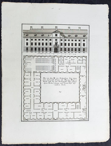
1740 Wolff & Corvinus Antique Arch Print of a Poorhouse near Stralau Gate Berlin
- Title : Das von dem H. von Grünenberg Seel. inventirte sogenandte Armen- oder Waysen-Hauss zu Berlin, nache bey dem Stralauischen Thor gelegen, ....
- Ref #: 93455
- Size: 19in x 12 1/2in (490mm x 335mm)
- Date : 1740
- Condition: (A+) Fine Condition
Description:
This large rare, original copper-plate engraved antique architectural print of the Poorhouse near the old Stralau Gate (Stralauer Tor) in Berlin - plate No. 8 of 16 - by Johann August Corvinus 1683 - 1738, after Andreas Mayers 1716 - 1782, was published in Eigentliche Abbildung des Prächtigen Königl. Lust Schlosses Charlottenburg, eine Meile von Berlin, sambt dem darhinden im Walde gelegenen schönen Lust Garten
(Set of 16 numbered plates, the first with the title, with plans and views of the buildings and gardens at Charlottenburg, the palace of the King of Prussia on the outskirts of Berlin.) by Jeremias Wolff Erben in 1740.
General Definitions:
Paper thickness and quality: - Heavy and stable
Paper color : - off white
Age of map color: -
Colors used: -
General color appearance: -
Paper size: - 19in x 12 1/2in (490mm x 335mm)
Plate size: - 14 1/2in x 10 1/2in (370mm x 260mm)
Margins: - Min 1in (25mm)
Imperfections:
Margins: - None
Plate area: - None
Verso: - None
Background:
Berlin straddles the banks of the River Spree, which flows into the River Havel (a tributary of the River Elbe) in the western borough of Spandau. Among the citys main topographical features are the many lakes in the western and southeastern boroughs formed by the Spree, Havel, and Dahme rivers (the largest of which is Lake Müggelsee). Due to its location in the European Plain, Berlin is influenced by a temperate seasonal climate. About one-third of the citys area is composed of forests, parks, gardens, rivers, canals and lakes. The city lies in the Central German dialect area, the Berlin dialect being a variant of the Lusatian-New Marchian dialects.
First documented in the 13th century and situated at the crossing of two important historic trade routes, Berlin became the capital of the Margraviate of Brandenburg (1417–1701), the Kingdom of Prussia (1701–1918), the German Empire (1871–1918), the Weimar Republic (1919–1933), and the Third Reich (1933–1945). Berlin in the 1920s was the third-largest municipality in the world. After World War II and its subsequent occupation by the victorious countries, the city was divided; West Berlin became a de facto West German exclave, surrounded by the Berlin Wall (1961–1989) and East German territory. East Berlin was declared capital of East Germany, while Bonn became the West German capital. Following German reunification in 1990, Berlin once again became the capital of all of Germany.
The Thirty Years War between 1618 and 1648 devastated Berlin. One third of its houses were damaged or destroyed, and the city lost half of its population. Frederick William, known as the Great Elector, who had succeeded his father George William as ruler in 1640, initiated a policy of promoting immigration and religious tolerance. With the Edict of Potsdam in 1685, Frederick William offered asylum to the French Huguenots.
By 1700, approximately 30 percent of Berlins residents were French, because of the Huguenot immigration. Many other immigrants came from Bohemia, Poland, and Salzburg.
Since 1618, the Margraviate of Brandenburg had been in personal union with the Duchy of Prussia. In 1701, the dual state formed the Kingdom of Prussia, as Frederick III, Elector of Brandenburg, crowned himself as king Frederick I in Prussia. Berlin became the capital of the new Kingdom, replacing Königsberg. This was a successful attempt to centralise the capital in the very far-flung state, and it was the first time the city began to grow. In 1709, Berlin merged with the four cities of Cölln, Friedrichswerder, Friedrichstadt and Dorotheenstadt under the name Berlin, Haupt- und Residenzstadt Berlin.
In 1740, Frederick II, known as Frederick the Great (1740–1786), came to power. Under the rule of Frederick II, Berlin became a center of the Enlightenment, but also, was briefly occupied during the Seven Years War by the Russian army. Following Frances victory in the War of the Fourth Coalition, Napoleon Bonaparte marched into Berlin in 1806, but granted self-government to the city. In 1815, the city became part of the new Province of Brandenburg.
The Industrial Revolution transformed Berlin during the 19th century; the citys economy and population expanded dramatically, and it became the main railway hub and economic centre of Germany. Additional suburbs soon developed and increased the area and population of Berlin. In 1861, neighbouring suburbs including Wedding, Moabit and several others were incorporated into Berlin. In 1871, Berlin became capital of the newly founded German Empire. In 1881, it became a city district separate from Brandenburg.
Wolff, Jeremais 1663 - 1724
Wolff was an German engraver and publisher. Born in Augsburg, he originally trained as a clock and automat maker, later changing course and opening a small copperplate engraving shop. His success was impressive and became one of the largest European art, print & map publishers in the first half of the 18th century. Wolff employed some of the best engravers of the time and although not an engraver himself, only Wolffs name was recorded on the engravings. Many of his engravers went uncredited for their work. In 1710 Wolff was one of the founder member of the Empire State Academy of Arts in Augsburg.
After his death in 1724, Wolffs publishing business was inherited by his sons and son-in-law, Johann Balthasar Probst (1673–1750) a notable engraver at the time. The firm continued on in Augsburg under the name Jeremias Wolff Erben.
Together with the Nuremberg copperplate engraver Paul Decker , Wolff published a series of engravings showing the war successes of Prince Eugene of Savoy in Italy , southern Germany and the Spanish Netherlands, during the War of the Spanish Succession . The prints are exhibited in the Museum of Military History, in Vienna .
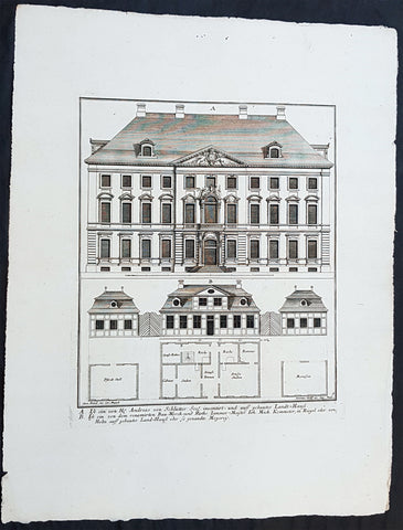
1740 Wolff & Corvinus Antique Arch Print of Berlin Mansions by A. von Schlütter
- Title : A. Ist ein von H. Andreas von Schlütter Seel. inventirt- und auff gebautes Landt-Hauss. B. Ist ein von dem renomirten Bau-Werck- und Raths Zimmer-Meister Joh. Mich. Kemmeter, in Riegel oder Holtz auff gebautes Land-Hauß oder so genandte Meyerey
- Ref #: 93445
- Size: 19in x 12 1/2in (490mm x 335mm)
- Date : 1740
- Condition: (A+) Fine Condition
Description:
This large rare, original copper-plate engraved antique architectural print of 18th century Mansions in Berlin designed by Andreas von Schlütter - plate No. 9 of 16 - by Johann August Corvinus 1683 - 1738, after Andreas Mayers 1716 - 1782, was published in Eigentliche Abbildung des Prächtigen Königl. Lust Schlosses Charlottenburg, eine Meile von Berlin, sambt dem darhinden im Walde gelegenen schönen Lust Garten
(Set of 16 numbered plates, the first with the title, with plans and views of the buildings and gardens at Charlottenburg, the palace of the King of Prussia on the outskirts of Berlin.) by Jeremias Wolff Erben in 1740.
General Definitions:
Paper thickness and quality: - Heavy and stable
Paper color : - off white
Age of map color: -
Colors used: -
General color appearance: -
Paper size: - 19in x 12 1/2in (490mm x 335mm)
Plate size: - 14 1/2in x 10 1/2in (370mm x 260mm)
Margins: - Min 1in (25mm)
Imperfections:
Margins: - None
Plate area: - None
Verso: - None
Background:
Berlin straddles the banks of the River Spree, which flows into the River Havel (a tributary of the River Elbe) in the western borough of Spandau. Among the citys main topographical features are the many lakes in the western and southeastern boroughs formed by the Spree, Havel, and Dahme rivers (the largest of which is Lake Müggelsee). Due to its location in the European Plain, Berlin is influenced by a temperate seasonal climate. About one-third of the citys area is composed of forests, parks, gardens, rivers, canals and lakes. The city lies in the Central German dialect area, the Berlin dialect being a variant of the Lusatian-New Marchian dialects.
First documented in the 13th century and situated at the crossing of two important historic trade routes, Berlin became the capital of the Margraviate of Brandenburg (1417–1701), the Kingdom of Prussia (1701–1918), the German Empire (1871–1918), the Weimar Republic (1919–1933), and the Third Reich (1933–1945). Berlin in the 1920s was the third-largest municipality in the world. After World War II and its subsequent occupation by the victorious countries, the city was divided; West Berlin became a de facto West German exclave, surrounded by the Berlin Wall (1961–1989) and East German territory. East Berlin was declared capital of East Germany, while Bonn became the West German capital. Following German reunification in 1990, Berlin once again became the capital of all of Germany.
The Thirty Years War between 1618 and 1648 devastated Berlin. One third of its houses were damaged or destroyed, and the city lost half of its population. Frederick William, known as the Great Elector, who had succeeded his father George William as ruler in 1640, initiated a policy of promoting immigration and religious tolerance. With the Edict of Potsdam in 1685, Frederick William offered asylum to the French Huguenots.
By 1700, approximately 30 percent of Berlins residents were French, because of the Huguenot immigration. Many other immigrants came from Bohemia, Poland, and Salzburg.
Since 1618, the Margraviate of Brandenburg had been in personal union with the Duchy of Prussia. In 1701, the dual state formed the Kingdom of Prussia, as Frederick III, Elector of Brandenburg, crowned himself as king Frederick I in Prussia. Berlin became the capital of the new Kingdom, replacing Königsberg. This was a successful attempt to centralise the capital in the very far-flung state, and it was the first time the city began to grow. In 1709, Berlin merged with the four cities of Cölln, Friedrichswerder, Friedrichstadt and Dorotheenstadt under the name Berlin, Haupt- und Residenzstadt Berlin.
In 1740, Frederick II, known as Frederick the Great (1740–1786), came to power. Under the rule of Frederick II, Berlin became a center of the Enlightenment, but also, was briefly occupied during the Seven Years War by the Russian army. Following Frances victory in the War of the Fourth Coalition, Napoleon Bonaparte marched into Berlin in 1806, but granted self-government to the city. In 1815, the city became part of the new Province of Brandenburg.
The Industrial Revolution transformed Berlin during the 19th century; the citys economy and population expanded dramatically, and it became the main railway hub and economic centre of Germany. Additional suburbs soon developed and increased the area and population of Berlin. In 1861, neighbouring suburbs including Wedding, Moabit and several others were incorporated into Berlin. In 1871, Berlin became capital of the newly founded German Empire. In 1881, it became a city district separate from Brandenburg.
Wolff, Jeremais 1663 - 1724
Wolff was an German engraver and publisher. Born in Augsburg, he originally trained as a clock and automat maker, later changing course and opening a small copperplate engraving shop. His success was impressive and became one of the largest European art, print & map publishers in the first half of the 18th century. Wolff employed some of the best engravers of the time and although not an engraver himself, only Wolffs name was recorded on the engravings. Many of his engravers went uncredited for their work. In 1710 Wolff was one of the founder member of the Empire State Academy of Arts in Augsburg.
After his death in 1724, Wolffs publishing business was inherited by his sons and son-in-law, Johann Balthasar Probst (1673–1750) a notable engraver at the time. The firm continued on in Augsburg under the name Jeremias Wolff Erben.
Together with the Nuremberg copperplate engraver Paul Decker , Wolff published a series of engravings showing the war successes of Prince Eugene of Savoy in Italy , southern Germany and the Spanish Netherlands, during the War of the Spanish Succession . The prints are exhibited in the Museum of Military History, in Vienna .
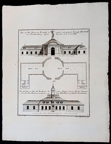
1740 Wolff & Corvinus Antique Arch Print of Charlottenburg Palace Stables Berlin
- Title : Der von Hr. Obrist von Eosander inventirte und gebaute Königl. Pferdt Stall zu Charlottenburg, dessen Faciata und Grund Riss. - Das gleichfals von Hr. Joh. Friederich v. Eosander Obristen General Quartier Meistern, und ersten Bau Directorn inventierte und gebaute Rath Hauss zu gedachten Charlottenburg
- Ref #: 93453
- Size: 19in x 12 1/2in (490mm x 335mm)
- Date : 1740
- Condition: (A+) Fine Condition
Description:
This large rare, original copper-plate engraved antique architectural print of the Royal Horse Stables at Charlottenburg Palace, Berlin - plate No. 11 of 16 - by Johann August Corvinus 1683 - 1738, after Andreas Mayers 1716 - 1782, was published in Eigentliche Abbildung des Prächtigen Königl. Lust Schlosses Charlottenburg, eine Meile von Berlin, sambt dem darhinden im Walde gelegenen schönen Lust Garten
(Set of 16 numbered plates, the first with the title, with plans and views of the buildings and gardens at Charlottenburg, the palace of the King of Prussia on the outskirts of Berlin.) by Jeremias Wolff Erben in 1740.
General Definitions:
Paper thickness and quality: - Heavy and stable
Paper color : - off white
Age of map color: -
Colors used: -
General color appearance: -
Paper size: - 19in x 12 1/2in (490mm x 335mm)
Plate size: - 14 1/2in x 10 1/2in (370mm x 260mm)
Margins: - Min 1in (25mm)
Imperfections:
Margins: - None
Plate area: - None
Verso: - None
Background:
Berlin straddles the banks of the River Spree, which flows into the River Havel (a tributary of the River Elbe) in the western borough of Spandau. Among the citys main topographical features are the many lakes in the western and southeastern boroughs formed by the Spree, Havel, and Dahme rivers (the largest of which is Lake Müggelsee). Due to its location in the European Plain, Berlin is influenced by a temperate seasonal climate. About one-third of the citys area is composed of forests, parks, gardens, rivers, canals and lakes. The city lies in the Central German dialect area, the Berlin dialect being a variant of the Lusatian-New Marchian dialects.
First documented in the 13th century and situated at the crossing of two important historic trade routes, Berlin became the capital of the Margraviate of Brandenburg (1417–1701), the Kingdom of Prussia (1701–1918), the German Empire (1871–1918), the Weimar Republic (1919–1933), and the Third Reich (1933–1945). Berlin in the 1920s was the third-largest municipality in the world. After World War II and its subsequent occupation by the victorious countries, the city was divided; West Berlin became a de facto West German exclave, surrounded by the Berlin Wall (1961–1989) and East German territory. East Berlin was declared capital of East Germany, while Bonn became the West German capital. Following German reunification in 1990, Berlin once again became the capital of all of Germany.
The Thirty Years War between 1618 and 1648 devastated Berlin. One third of its houses were damaged or destroyed, and the city lost half of its population. Frederick William, known as the Great Elector, who had succeeded his father George William as ruler in 1640, initiated a policy of promoting immigration and religious tolerance. With the Edict of Potsdam in 1685, Frederick William offered asylum to the French Huguenots.
By 1700, approximately 30 percent of Berlins residents were French, because of the Huguenot immigration. Many other immigrants came from Bohemia, Poland, and Salzburg.
Since 1618, the Margraviate of Brandenburg had been in personal union with the Duchy of Prussia. In 1701, the dual state formed the Kingdom of Prussia, as Frederick III, Elector of Brandenburg, crowned himself as king Frederick I in Prussia. Berlin became the capital of the new Kingdom, replacing Königsberg. This was a successful attempt to centralise the capital in the very far-flung state, and it was the first time the city began to grow. In 1709, Berlin merged with the four cities of Cölln, Friedrichswerder, Friedrichstadt and Dorotheenstadt under the name Berlin, Haupt- und Residenzstadt Berlin.
In 1740, Frederick II, known as Frederick the Great (1740–1786), came to power. Under the rule of Frederick II, Berlin became a center of the Enlightenment, but also, was briefly occupied during the Seven Years War by the Russian army. Following Frances victory in the War of the Fourth Coalition, Napoleon Bonaparte marched into Berlin in 1806, but granted self-government to the city. In 1815, the city became part of the new Province of Brandenburg.
The Industrial Revolution transformed Berlin during the 19th century; the citys economy and population expanded dramatically, and it became the main railway hub and economic centre of Germany. Additional suburbs soon developed and increased the area and population of Berlin. In 1861, neighbouring suburbs including Wedding, Moabit and several others were incorporated into Berlin. In 1871, Berlin became capital of the newly founded German Empire. In 1881, it became a city district separate from Brandenburg.
Wolff, Jeremais 1663 - 1724
Wolff was an German engraver and publisher. Born in Augsburg, he originally trained as a clock and automat maker, later changing course and opening a small copperplate engraving shop. His success was impressive and became one of the largest European art, print & map publishers in the first half of the 18th century. Wolff employed some of the best engravers of the time and although not an engraver himself, only Wolffs name was recorded on the engravings. Many of his engravers went uncredited for their work. In 1710 Wolff was one of the founder member of the Empire State Academy of Arts in Augsburg.
After his death in 1724, Wolffs publishing business was inherited by his sons and son-in-law, Johann Balthasar Probst (1673–1750) a notable engraver at the time. The firm continued on in Augsburg under the name Jeremias Wolff Erben.
Together with the Nuremberg copperplate engraver Paul Decker , Wolff published a series of engravings showing the war successes of Prince Eugene of Savoy in Italy , southern Germany and the Spanish Netherlands, during the War of the Spanish Succession . The prints are exhibited in the Museum of Military History, in Vienna .
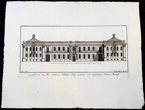
1740 Wolff & Corvinus Antique Arch Print of Charlottenburg Palace Stables Berlin
- Title : Ist ein von Hr. Andreas Schlütter Seel. inventirt und aufgebauer Schöner Marstall Datierung
- Ref #: 93447
- Size: 19in x 12 1/2in (490mm x 335mm)
- Date : 1740
- Condition: (A+) Fine Condition
Description:
This large rare, original copper-plate engraved antique architectural print, view of the facade of the Charlottenburg Palace stables in Berlin - plate No.15 of 16 - by Johann August Corvinus 1683 - 1738, after Andreas Mayers 1716 - 1782, was published in Eigentliche Abbildung des Prächtigen Königl. Lust Schlosses Charlottenburg, eine Meile von Berlin, sambt dem darhinden im Walde gelegenen schönen Lust Garten
(Set of 16 numbered plates, the first with the title, with plans and views of the buildings and gardens at Charlottenburg, the palace of the King of Prussia on the outskirts of Berlin.) by Jeremias Wolff Erben in 1740.
General Definitions:
Paper thickness and quality: - Heavy and stable
Paper color : - off white
Age of map color: -
Colors used: -
General color appearance: -
Paper size: - 19in x 12 1/2in (490mm x 335mm)
Plate size: - 14 1/2in x 10 1/2in (370mm x 260mm)
Margins: - Min 1in (25mm)
Imperfections:
Margins: - None
Plate area: - None
Verso: - None
Background:
Berlin straddles the banks of the River Spree, which flows into the River Havel (a tributary of the River Elbe) in the western borough of Spandau. Among the citys main topographical features are the many lakes in the western and southeastern boroughs formed by the Spree, Havel, and Dahme rivers (the largest of which is Lake Müggelsee). Due to its location in the European Plain, Berlin is influenced by a temperate seasonal climate. About one-third of the citys area is composed of forests, parks, gardens, rivers, canals and lakes. The city lies in the Central German dialect area, the Berlin dialect being a variant of the Lusatian-New Marchian dialects.
First documented in the 13th century and situated at the crossing of two important historic trade routes, Berlin became the capital of the Margraviate of Brandenburg (1417–1701), the Kingdom of Prussia (1701–1918), the German Empire (1871–1918), the Weimar Republic (1919–1933), and the Third Reich (1933–1945). Berlin in the 1920s was the third-largest municipality in the world. After World War II and its subsequent occupation by the victorious countries, the city was divided; West Berlin became a de facto West German exclave, surrounded by the Berlin Wall (1961–1989) and East German territory. East Berlin was declared capital of East Germany, while Bonn became the West German capital. Following German reunification in 1990, Berlin once again became the capital of all of Germany.
The Thirty Years War between 1618 and 1648 devastated Berlin. One third of its houses were damaged or destroyed, and the city lost half of its population. Frederick William, known as the Great Elector, who had succeeded his father George William as ruler in 1640, initiated a policy of promoting immigration and religious tolerance. With the Edict of Potsdam in 1685, Frederick William offered asylum to the French Huguenots.
By 1700, approximately 30 percent of Berlins residents were French, because of the Huguenot immigration. Many other immigrants came from Bohemia, Poland, and Salzburg.
Since 1618, the Margraviate of Brandenburg had been in personal union with the Duchy of Prussia. In 1701, the dual state formed the Kingdom of Prussia, as Frederick III, Elector of Brandenburg, crowned himself as king Frederick I in Prussia. Berlin became the capital of the new Kingdom, replacing Königsberg. This was a successful attempt to centralise the capital in the very far-flung state, and it was the first time the city began to grow. In 1709, Berlin merged with the four cities of Cölln, Friedrichswerder, Friedrichstadt and Dorotheenstadt under the name Berlin, Haupt- und Residenzstadt Berlin.
In 1740, Frederick II, known as Frederick the Great (1740–1786), came to power. Under the rule of Frederick II, Berlin became a center of the Enlightenment, but also, was briefly occupied during the Seven Years War by the Russian army. Following Frances victory in the War of the Fourth Coalition, Napoleon Bonaparte marched into Berlin in 1806, but granted self-government to the city. In 1815, the city became part of the new Province of Brandenburg.
The Industrial Revolution transformed Berlin during the 19th century; the citys economy and population expanded dramatically, and it became the main railway hub and economic centre of Germany. Additional suburbs soon developed and increased the area and population of Berlin. In 1861, neighbouring suburbs including Wedding, Moabit and several others were incorporated into Berlin. In 1871, Berlin became capital of the newly founded German Empire. In 1881, it became a city district separate from Brandenburg.
Wolff, Jeremais 1663 - 1724
Wolff was an German engraver and publisher. Born in Augsburg, he originally trained as a clock and automat maker, later changing course and opening a small copperplate engraving shop. His success was impressive and became one of the largest European art, print & map publishers in the first half of the 18th century. Wolff employed some of the best engravers of the time and although not an engraver himself, only Wolffs name was recorded on the engravings. Many of his engravers went uncredited for their work. In 1710 Wolff was one of the founder member of the Empire State Academy of Arts in Augsburg.
After his death in 1724, Wolffs publishing business was inherited by his sons and son-in-law, Johann Balthasar Probst (1673–1750) a notable engraver at the time. The firm continued on in Augsburg under the name Jeremias Wolff Erben.
Together with the Nuremberg copperplate engraver Paul Decker , Wolff published a series of engravings showing the war successes of Prince Eugene of Savoy in Italy , southern Germany and the Spanish Netherlands, during the War of the Spanish Succession . The prints are exhibited in the Museum of Military History, in Vienna .
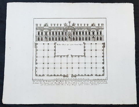
1740 Wolff & Corvinus Antique Arch Print of The Royal Arsenal in Berlin Germany
- Title : Das von dem H. Architect und Bau-Meister Nering Seel. angefangne, und von dem unvergleichlichen Architect Ober-Ingenier und Bau-Meistern H. Obrist Both in vollkommenen Perfection Stand gebrachte und von jedermann belobte Herr. Zeug-Haus, dessen vordere faciata
- Ref #: 93454
- Size: 19in x 12 1/2in (490mm x 335mm)
- Date : 1740
- Condition: (A+) Fine Condition
Description:
This large rare, original copper-plate engraved antique architectural print, view & plan of The Royal Arsenal in Berlin Houses - plate No.13 of 16 - by Johann August Corvinus 1683 - 1738, after Andreas Mayers 1716 - 1782, was published in Eigentliche Abbildung des Prächtigen Königl. Lust Schlosses Charlottenburg, eine Meile von Berlin, sambt dem darhinden im Walde gelegenen schönen Lust Garten
(Set of 16 numbered plates, the first with the title, with plans and views of the buildings and gardens at Charlottenburg, the palace of the King of Prussia on the outskirts of Berlin.) by Jeremias Wolff Erben in 1740.
General Definitions:
Paper thickness and quality: - Heavy and stable
Paper color : - off white
Age of map color: -
Colors used: -
General color appearance: -
Paper size: - 19in x 12 1/2in (490mm x 335mm)
Plate size: - 14 1/2in x 10 1/2in (370mm x 260mm)
Margins: - Min 1in (25mm)
Imperfections:
Margins: - None
Plate area: - None
Verso: - None
Background:
Berlin straddles the banks of the River Spree, which flows into the River Havel (a tributary of the River Elbe) in the western borough of Spandau. Among the citys main topographical features are the many lakes in the western and southeastern boroughs formed by the Spree, Havel, and Dahme rivers (the largest of which is Lake Müggelsee). Due to its location in the European Plain, Berlin is influenced by a temperate seasonal climate. About one-third of the citys area is composed of forests, parks, gardens, rivers, canals and lakes. The city lies in the Central German dialect area, the Berlin dialect being a variant of the Lusatian-New Marchian dialects.
First documented in the 13th century and situated at the crossing of two important historic trade routes, Berlin became the capital of the Margraviate of Brandenburg (1417–1701), the Kingdom of Prussia (1701–1918), the German Empire (1871–1918), the Weimar Republic (1919–1933), and the Third Reich (1933–1945). Berlin in the 1920s was the third-largest municipality in the world. After World War II and its subsequent occupation by the victorious countries, the city was divided; West Berlin became a de facto West German exclave, surrounded by the Berlin Wall (1961–1989) and East German territory. East Berlin was declared capital of East Germany, while Bonn became the West German capital. Following German reunification in 1990, Berlin once again became the capital of all of Germany.
The Thirty Years War between 1618 and 1648 devastated Berlin. One third of its houses were damaged or destroyed, and the city lost half of its population. Frederick William, known as the Great Elector, who had succeeded his father George William as ruler in 1640, initiated a policy of promoting immigration and religious tolerance. With the Edict of Potsdam in 1685, Frederick William offered asylum to the French Huguenots.
By 1700, approximately 30 percent of Berlins residents were French, because of the Huguenot immigration. Many other immigrants came from Bohemia, Poland, and Salzburg.
Since 1618, the Margraviate of Brandenburg had been in personal union with the Duchy of Prussia. In 1701, the dual state formed the Kingdom of Prussia, as Frederick III, Elector of Brandenburg, crowned himself as king Frederick I in Prussia. Berlin became the capital of the new Kingdom, replacing Königsberg. This was a successful attempt to centralise the capital in the very far-flung state, and it was the first time the city began to grow. In 1709, Berlin merged with the four cities of Cölln, Friedrichswerder, Friedrichstadt and Dorotheenstadt under the name Berlin, Haupt- und Residenzstadt Berlin.
In 1740, Frederick II, known as Frederick the Great (1740–1786), came to power. Under the rule of Frederick II, Berlin became a center of the Enlightenment, but also, was briefly occupied during the Seven Years War by the Russian army. Following Frances victory in the War of the Fourth Coalition, Napoleon Bonaparte marched into Berlin in 1806, but granted self-government to the city. In 1815, the city became part of the new Province of Brandenburg.
The Industrial Revolution transformed Berlin during the 19th century; the citys economy and population expanded dramatically, and it became the main railway hub and economic centre of Germany. Additional suburbs soon developed and increased the area and population of Berlin. In 1861, neighbouring suburbs including Wedding, Moabit and several others were incorporated into Berlin. In 1871, Berlin became capital of the newly founded German Empire. In 1881, it became a city district separate from Brandenburg.
Wolff, Jeremais 1663 - 1724
Wolff was an German engraver and publisher. Born in Augsburg, he originally trained as a clock and automat maker, later changing course and opening a small copperplate engraving shop. His success was impressive and became one of the largest European art, print & map publishers in the first half of the 18th century. Wolff employed some of the best engravers of the time and although not an engraver himself, only Wolffs name was recorded on the engravings. Many of his engravers went uncredited for their work. In 1710 Wolff was one of the founder member of the Empire State Academy of Arts in Augsburg.
After his death in 1724, Wolffs publishing business was inherited by his sons and son-in-law, Johann Balthasar Probst (1673–1750) a notable engraver at the time. The firm continued on in Augsburg under the name Jeremias Wolff Erben.
Together with the Nuremberg copperplate engraver Paul Decker , Wolff published a series of engravings showing the war successes of Prince Eugene of Savoy in Italy , southern Germany and the Spanish Netherlands, during the War of the Spanish Succession . The prints are exhibited in the Museum of Military History, in Vienna .
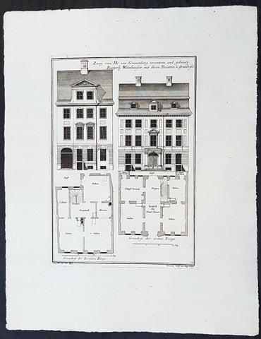
1740 Wolff & Corvinus Antique Arch Print Plans of Residential Houses in Berlin
- Title : Zwey von Hr. von Grünenberg inventirte und gebaute Burgerl. Wohnhäusser mit ihren Faciaten u. Grundrissen
- Ref #: 93450
- Size: 19in x 12 1/2in (490mm x 335mm)
- Date : 1740
- Condition: (A+) Fine Condition
Description:
This large rare, original copper-plate engraved antique architectural print plans of Berlin Houses - plate No. 12 of 16 - by Johann August Corvinus 1683 - 1738, after Andreas Mayers 1716 - 1782, was published in Eigentliche Abbildung des Prächtigen Königl. Lust Schlosses Charlottenburg, eine Meile von Berlin, sambt dem darhinden im Walde gelegenen schönen Lust Garten
(Set of 16 numbered plates, the first with the title, with plans and views of the buildings and gardens at Charlottenburg, the palace of the King of Prussia on the outskirts of Berlin.) by Jeremias Wolff Erben in 1740.
General Definitions:
Paper thickness and quality: - Heavy and stable
Paper color : - off white
Age of map color: -
Colors used: -
General color appearance: -
Paper size: - 19in x 12 1/2in (490mm x 335mm)
Plate size: - 14 1/2in x 10 1/2in (370mm x 260mm)
Margins: - Min 1in (25mm)
Imperfections:
Margins: - None
Plate area: - None
Verso: - None
Background:
Berlin straddles the banks of the River Spree, which flows into the River Havel (a tributary of the River Elbe) in the western borough of Spandau. Among the citys main topographical features are the many lakes in the western and southeastern boroughs formed by the Spree, Havel, and Dahme rivers (the largest of which is Lake Müggelsee). Due to its location in the European Plain, Berlin is influenced by a temperate seasonal climate. About one-third of the citys area is composed of forests, parks, gardens, rivers, canals and lakes. The city lies in the Central German dialect area, the Berlin dialect being a variant of the Lusatian-New Marchian dialects.
First documented in the 13th century and situated at the crossing of two important historic trade routes, Berlin became the capital of the Margraviate of Brandenburg (1417–1701), the Kingdom of Prussia (1701–1918), the German Empire (1871–1918), the Weimar Republic (1919–1933), and the Third Reich (1933–1945). Berlin in the 1920s was the third-largest municipality in the world. After World War II and its subsequent occupation by the victorious countries, the city was divided; West Berlin became a de facto West German exclave, surrounded by the Berlin Wall (1961–1989) and East German territory. East Berlin was declared capital of East Germany, while Bonn became the West German capital. Following German reunification in 1990, Berlin once again became the capital of all of Germany.
The Thirty Years War between 1618 and 1648 devastated Berlin. One third of its houses were damaged or destroyed, and the city lost half of its population. Frederick William, known as the Great Elector, who had succeeded his father George William as ruler in 1640, initiated a policy of promoting immigration and religious tolerance. With the Edict of Potsdam in 1685, Frederick William offered asylum to the French Huguenots.
By 1700, approximately 30 percent of Berlins residents were French, because of the Huguenot immigration. Many other immigrants came from Bohemia, Poland, and Salzburg.
Since 1618, the Margraviate of Brandenburg had been in personal union with the Duchy of Prussia. In 1701, the dual state formed the Kingdom of Prussia, as Frederick III, Elector of Brandenburg, crowned himself as king Frederick I in Prussia. Berlin became the capital of the new Kingdom, replacing Königsberg. This was a successful attempt to centralise the capital in the very far-flung state, and it was the first time the city began to grow. In 1709, Berlin merged with the four cities of Cölln, Friedrichswerder, Friedrichstadt and Dorotheenstadt under the name Berlin, Haupt- und Residenzstadt Berlin.
In 1740, Frederick II, known as Frederick the Great (1740–1786), came to power. Under the rule of Frederick II, Berlin became a center of the Enlightenment, but also, was briefly occupied during the Seven Years War by the Russian army. Following Frances victory in the War of the Fourth Coalition, Napoleon Bonaparte marched into Berlin in 1806, but granted self-government to the city. In 1815, the city became part of the new Province of Brandenburg.
The Industrial Revolution transformed Berlin during the 19th century; the citys economy and population expanded dramatically, and it became the main railway hub and economic centre of Germany. Additional suburbs soon developed and increased the area and population of Berlin. In 1861, neighbouring suburbs including Wedding, Moabit and several others were incorporated into Berlin. In 1871, Berlin became capital of the newly founded German Empire. In 1881, it became a city district separate from Brandenburg.
Wolff, Jeremais 1663 - 1724
Wolff was an German engraver and publisher. Born in Augsburg, he originally trained as a clock and automat maker, later changing course and opening a small copperplate engraving shop. His success was impressive and became one of the largest European art, print & map publishers in the first half of the 18th century. Wolff employed some of the best engravers of the time and although not an engraver himself, only Wolffs name was recorded on the engravings. Many of his engravers went uncredited for their work. In 1710 Wolff was one of the founder member of the Empire State Academy of Arts in Augsburg.
After his death in 1724, Wolffs publishing business was inherited by his sons and son-in-law, Johann Balthasar Probst (1673–1750) a notable engraver at the time. The firm continued on in Augsburg under the name Jeremias Wolff Erben.
Together with the Nuremberg copperplate engraver Paul Decker , Wolff published a series of engravings showing the war successes of Prince Eugene of Savoy in Italy , southern Germany and the Spanish Netherlands, during the War of the Spanish Succession . The prints are exhibited in the Museum of Military History, in Vienna .
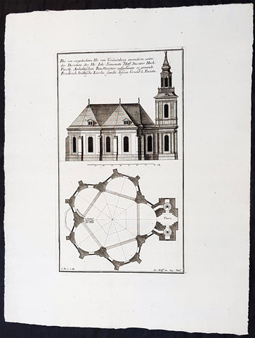
1740 Wolff & Corvinus Antique Arch. Print Jerusalem Church Friedrichstadt.Berlin
- Title : Die von vorgedachten Hr. von Grünenberg invendierte, unter der Direction des Hr. Ioh. Simonetti Hoff Stucator Hoch-Fürstl. Anhaltischen BauMeister aufgebaute so genande Friderich Stättische Kirche sampt dessen Grund u. Faciata.
- Ref #: 93458
- Size: 19in x 12 1/2in (490mm x 335mm)
- Date : 1740
- Condition: (A+) Fine Condition
Description:
This large rare, original copper-plate engraved antique architectural print of the Parochialkirche (literally the Reformed parochial church) in the Mitte suburb of Berlin - plate No. 7 of 16 - by Johann August Corvinus 1683 - 1738, after Andreas Mayers 1716 - 1782, was published in Eigentliche Abbildung des Prächtigen Königl. Lust Schlosses Charlottenburg, eine Meile von Berlin, sambt dem darhinden im Walde gelegenen schönen Lust Garten
(Set of 16 numbered plates, the first with the title, with plans and views of the buildings and gardens at Charlottenburg, the palace of the King of Prussia on the outskirts of Berlin.) by Jeremias Wolff Erben in 1740.
General Definitions:
Paper thickness and quality: - Heavy and stable
Paper color : - off white
Age of map color: -
Colors used: -
General color appearance: -
Paper size: - 19in x 12 1/2in (490mm x 335mm)
Plate size: - 14 1/2in x 10 1/2in (370mm x 260mm)
Margins: - Min 1in (25mm)
Imperfections:
Margins: - None
Plate area: - None
Verso: - None
Background:
Berlin straddles the banks of the River Spree, which flows into the River Havel (a tributary of the River Elbe) in the western borough of Spandau. Among the citys main topographical features are the many lakes in the western and southeastern boroughs formed by the Spree, Havel, and Dahme rivers (the largest of which is Lake Müggelsee). Due to its location in the European Plain, Berlin is influenced by a temperate seasonal climate. About one-third of the citys area is composed of forests, parks, gardens, rivers, canals and lakes. The city lies in the Central German dialect area, the Berlin dialect being a variant of the Lusatian-New Marchian dialects.
First documented in the 13th century and situated at the crossing of two important historic trade routes, Berlin became the capital of the Margraviate of Brandenburg (1417–1701), the Kingdom of Prussia (1701–1918), the German Empire (1871–1918), the Weimar Republic (1919–1933), and the Third Reich (1933–1945). Berlin in the 1920s was the third-largest municipality in the world. After World War II and its subsequent occupation by the victorious countries, the city was divided; West Berlin became a de facto West German exclave, surrounded by the Berlin Wall (1961–1989) and East German territory. East Berlin was declared capital of East Germany, while Bonn became the West German capital. Following German reunification in 1990, Berlin once again became the capital of all of Germany.
The Thirty Years War between 1618 and 1648 devastated Berlin. One third of its houses were damaged or destroyed, and the city lost half of its population. Frederick William, known as the Great Elector, who had succeeded his father George William as ruler in 1640, initiated a policy of promoting immigration and religious tolerance. With the Edict of Potsdam in 1685, Frederick William offered asylum to the French Huguenots.
By 1700, approximately 30 percent of Berlins residents were French, because of the Huguenot immigration. Many other immigrants came from Bohemia, Poland, and Salzburg.
Since 1618, the Margraviate of Brandenburg had been in personal union with the Duchy of Prussia. In 1701, the dual state formed the Kingdom of Prussia, as Frederick III, Elector of Brandenburg, crowned himself as king Frederick I in Prussia. Berlin became the capital of the new Kingdom, replacing Königsberg. This was a successful attempt to centralise the capital in the very far-flung state, and it was the first time the city began to grow. In 1709, Berlin merged with the four cities of Cölln, Friedrichswerder, Friedrichstadt and Dorotheenstadt under the name Berlin, Haupt- und Residenzstadt Berlin.
In 1740, Frederick II, known as Frederick the Great (1740–1786), came to power. Under the rule of Frederick II, Berlin became a center of the Enlightenment, but also, was briefly occupied during the Seven Years War by the Russian army. Following Frances victory in the War of the Fourth Coalition, Napoleon Bonaparte marched into Berlin in 1806, but granted self-government to the city. In 1815, the city became part of the new Province of Brandenburg.
The Industrial Revolution transformed Berlin during the 19th century; the citys economy and population expanded dramatically, and it became the main railway hub and economic centre of Germany. Additional suburbs soon developed and increased the area and population of Berlin. In 1861, neighbouring suburbs including Wedding, Moabit and several others were incorporated into Berlin. In 1871, Berlin became capital of the newly founded German Empire. In 1881, it became a city district separate from Brandenburg.
Wolff, Jeremais 1663 - 1724
Wolff was an German engraver and publisher. Born in Augsburg, he originally trained as a clock and automat maker, later changing course and opening a small copperplate engraving shop. His success was impressive and became one of the largest European art, print & map publishers in the first half of the 18th century. Wolff employed some of the best engravers of the time and although not an engraver himself, only Wolffs name was recorded on the engravings. Many of his engravers went uncredited for their work. In 1710 Wolff was one of the founder member of the Empire State Academy of Arts in Augsburg.
After his death in 1724, Wolffs publishing business was inherited by his sons and son-in-law, Johann Balthasar Probst (1673–1750) a notable engraver at the time. The firm continued on in Augsburg under the name Jeremias Wolff Erben.
Together with the Nuremberg copperplate engraver Paul Decker , Wolff published a series of engravings showing the war successes of Prince Eugene of Savoy in Italy , southern Germany and the Spanish Netherlands, during the War of the Spanish Succession . The prints are exhibited in the Museum of Military History, in Vienna .
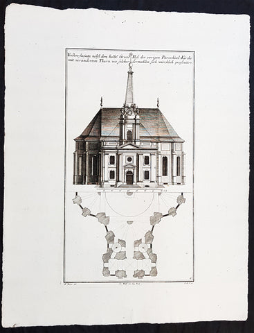
1740 Wolff & Corvinus Antique Arch. Print of the Parochialkirche in Mitte Berlin
- Title : Vordere faciata nebst dem halben Grund Riß der vorigen Parochial-Kirche mit verändertem Thurn wie solcher dermahlen sich würklich presentiert. Frontriß, darunter der halbe Grundriß.
- Ref #: 93459
- Size: 19in x 12 1/2in (490mm x 335mm)
- Date : 1740
- Condition: (A+) Fine Condition
Description:
This large rare, original copper-plate engraved antique architectural print of the Parochialkirche (literally the Reformed parochial church) in the Mitte suburb of Berlin - plate No. 6 of 16 - by Johann August Corvinus 1683 - 1738, after Andreas Mayers 1716 - 1782, was published in Eigentliche Abbildung des Prächtigen Königl. Lust Schlosses Charlottenburg, eine Meile von Berlin, sambt dem darhinden im Walde gelegenen schönen Lust Garten.
(Set of 16 numbered plates, the first with the title, with plans and views of the buildings and gardens at Charlottenburg, the palace of the King of Prussia on the outskirts of Berlin.) by Jeremias Wolff Erben in 1740.
General Definitions:
Paper thickness and quality: - Heavy and stable
Paper color : - off white
Age of map color: -
Colors used: -
General color appearance: -
Paper size: - 19in x 12 1/2in (490mm x 335mm)
Plate size: - 14 1/2in x 10 1/2in (370mm x 260mm)
Margins: - Min 1in (25mm)
Imperfections:
Margins: - None
Plate area: - None
Verso: - None
Background:
Berlin straddles the banks of the River Spree, which flows into the River Havel (a tributary of the River Elbe) in the western borough of Spandau. Among the citys main topographical features are the many lakes in the western and southeastern boroughs formed by the Spree, Havel, and Dahme rivers (the largest of which is Lake Müggelsee). Due to its location in the European Plain, Berlin is influenced by a temperate seasonal climate. About one-third of the citys area is composed of forests, parks, gardens, rivers, canals and lakes. The city lies in the Central German dialect area, the Berlin dialect being a variant of the Lusatian-New Marchian dialects.
First documented in the 13th century and situated at the crossing of two important historic trade routes, Berlin became the capital of the Margraviate of Brandenburg (1417–1701), the Kingdom of Prussia (1701–1918), the German Empire (1871–1918), the Weimar Republic (1919–1933), and the Third Reich (1933–1945). Berlin in the 1920s was the third-largest municipality in the world. After World War II and its subsequent occupation by the victorious countries, the city was divided; West Berlin became a de facto West German exclave, surrounded by the Berlin Wall (1961–1989) and East German territory. East Berlin was declared capital of East Germany, while Bonn became the West German capital. Following German reunification in 1990, Berlin once again became the capital of all of Germany.
The Thirty Years War between 1618 and 1648 devastated Berlin. One third of its houses were damaged or destroyed, and the city lost half of its population. Frederick William, known as the Great Elector, who had succeeded his father George William as ruler in 1640, initiated a policy of promoting immigration and religious tolerance. With the Edict of Potsdam in 1685, Frederick William offered asylum to the French Huguenots.
By 1700, approximately 30 percent of Berlins residents were French, because of the Huguenot immigration. Many other immigrants came from Bohemia, Poland, and Salzburg.
Since 1618, the Margraviate of Brandenburg had been in personal union with the Duchy of Prussia. In 1701, the dual state formed the Kingdom of Prussia, as Frederick III, Elector of Brandenburg, crowned himself as king Frederick I in Prussia. Berlin became the capital of the new Kingdom, replacing Königsberg. This was a successful attempt to centralise the capital in the very far-flung state, and it was the first time the city began to grow. In 1709, Berlin merged with the four cities of Cölln, Friedrichswerder, Friedrichstadt and Dorotheenstadt under the name Berlin, Haupt- und Residenzstadt Berlin.
In 1740, Frederick II, known as Frederick the Great (1740–1786), came to power. Under the rule of Frederick II, Berlin became a center of the Enlightenment, but also, was briefly occupied during the Seven Years War by the Russian army. Following Frances victory in the War of the Fourth Coalition, Napoleon Bonaparte marched into Berlin in 1806, but granted self-government to the city. In 1815, the city became part of the new Province of Brandenburg.
The Industrial Revolution transformed Berlin during the 19th century; the citys economy and population expanded dramatically, and it became the main railway hub and economic centre of Germany. Additional suburbs soon developed and increased the area and population of Berlin. In 1861, neighbouring suburbs including Wedding, Moabit and several others were incorporated into Berlin. In 1871, Berlin became capital of the newly founded German Empire. In 1881, it became a city district separate from Brandenburg.
Wolff, Jeremais 1663 - 1724
Wolff was an German engraver and publisher. Born in Augsburg, he originally trained as a clock and automat maker, later changing course and opening a small copperplate engraving shop. His success was impressive and became one of the largest European art, print & map publishers in the first half of the 18th century. Wolff employed some of the best engravers of the time and although not an engraver himself, only Wolffs name was recorded on the engravings. Many of his engravers went uncredited for their work. In 1710 Wolff was one of the founder member of the Empire State Academy of Arts in Augsburg.
After his death in 1724, Wolffs publishing business was inherited by his sons and son-in-law, Johann Balthasar Probst (1673–1750) a notable engraver at the time. The firm continued on in Augsburg under the name Jeremias Wolff Erben.
Together with the Nuremberg copperplate engraver Paul Decker , Wolff published a series of engravings showing the war successes of Prince Eugene of Savoy in Italy , southern Germany and the Spanish Netherlands, during the War of the Spanish Succession . The prints are exhibited in the Museum of Military History, in Vienna .
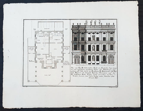
1740 Wolff & Corvinus Antique Architectural Print Buildings, Gardens Berlin - No. 14
- Title : Das von Title Hr. Geheimbten Rath von Krossecks Seel. inventirt - und aussgebaute
- Ref #: 93448
- Size: 19in x 12 1/2in (490mm x 335mm)
- Date : 1740
- Condition: (A+) Fine Condition
Description:
This large fine, original copper-plate engraved antique architectural print of buildings & gardens in the Charlottenburg suburb of Berlin & Charlottenburg Palace, - plate No. 14 of 16 - by Johann August Corvinus 1683 - 1738, after Andreas Mayers 1716 - 1782, was published in Eigentliche Abbildung des Prächtigen Königl. Lust Schlosses Charlottenburg, eine Meile von Berlin, sambt dem darhinden im Walde gelegenen schönen Lust Garten
(Set of 16 numbered plates, the first with the title, with plans and views of the buildings and gardens at Charlottenburg, the palace of the King of Prussia on the outskirts of Berlin.) by Jeremias Wolff Erben in 1740.
General Definitions:
Paper thickness and quality: - Heavy and stable
Paper color : - off white
Age of map color: -
Colors used: -
General color appearance: -
Paper size: - 19in x 12 1/2in (490mm x 335mm)
Plate size: - 14 1/2in x 10 1/2in (370mm x 260mm)
Margins: - Min 1in (25mm)
Imperfections:
Margins: - None
Plate area: - None
Verso: - None
Background:
Charlottenburg is an affluent locality of Berlin within the borough of Charlottenburg-Wilmersdorf. Established as a town in 1705 and named after late Sophia Charlotte of Hanover, Queen consort of Prussia, it is best known for Charlottenburg Palace, the largest surviving royal palace in Berlin, and the adjacent museums.
Charlottenburg is located in Berlins inner city, west of the Großer Tiergarten park. Its historic core, the former village green of Alt Lietzow, is situated on the southern shore of the Spree River running through the Berlin glacial valley. The Straße des 17. Juni road, former Charlottenburger Chaussee, which runs eastwards from Charlottenburg Gate through the Tiergarten park to Brandenburg Gate, connects Charlottenburg with the historic centre of Berlin-Mitte.
In the north and west, the Berlin Ringbahn and the Bundesautobahn 100 (Stadtring) mark the border with the Charlottenburg-Nord and Westend suburbs. Adjacent in the south is the territory of Wilmersdorf. Charlottenburg also borders on the district of Halensee in the southwest, as well as on Moabit, Hansaviertel and Tiergarten (all part of the Mitte borough) in the east and on Schöneberg in the southeast.
In 1695, Sophia Charlotte of Hanover received Lietzow from her husband, Elector Frederick III of Brandenburg, in exchange for her estates in Caputh and Langerwisch near Potsdam. Frederick had a summer residence built there for Sophie Charlotte by the architect Johann Arnold Nering between 1695 and 1699. After he had crowned himself Frederick I, King in Prussia, the Lützenburg castle was extended into a stately building with a cour dhonneur. The Swedish master builder Johann Friedrich Eosander supervised this work. Sophie Charlotte died in February 1705; shortly afterwards the settlement facing the palace was called Charlottenburg - the palace itself became Schloss Charlottenburg - and chartered as a town on April 5, 1705. The king served as the towns mayor until the historic village of Lietzow was incorporated into Charlottenburg in 1720.
Fredericks successor as king, Frederick William I of Prussia, rarely stayed at the palace, which depressed the small town of Charlottenburg. Frederick William even tried to revoke the towns privileges. With the coronation of his successor Frederick II in 1740 the towns significance increased, as regular celebrations again took place at the palace. Between 1740 and 1747 Georg Wenzeslaus von Knobelsdorff built the eastern New Wing as Fredericks residence. Later, Frederick II preferred the palace of Sanssouci, which he had partly designed himself.
When Frederick II died in 1786, his nephew Frederick William II succeeded him, and Charlottenburg became the favourite royal residence, and remained so for his son and successor Frederick William III (reigned 1797-1840). After the defeat of the Prussian army at Jena in 1806, the French occupied Berlin. Napoleon took over the palace, while his troops made a camp nearby. Charlottenburg became part of the new Prussian Province of Brandenburg in 1815 after the Napoleonic Wars.
In the late 18th century, Charlottenburgs development did not depend only on the crown. The town became a recreational area for the expanding city of Berlin. Its first true inn opened in the 1770s, in the street then called Berliner Straße (now Otto-Suhr-Allee), and many other inns and beer gardens were to follow, popular for weekend parties especially. Berliners seeking leisure and entertainment came by boat, by carriage and later by horse-drawn trams, above all to a large amusement park at the shore of the Spree river called Flora, that went into bankruptcy in 1904.
From the 1860s on the wealthy Bourgeoisie of Berlin discovered Charlottenburg as a residential area, among the first were Gerson von Bleichröder and Ernst Werner von Siemens, who had a villa built in the Berliner Straße in 1862. At the same time industrial companies like Siemens & Halske and Schering erected large factories in the north-east, at the border with the Moabit district of Berlin. In 1877 Charlottenburg received town privileges and until World War I saw an enormous increase of population with 100,000 inhabitants as of 1893 and a population of 306,000 in 1920, being the second largest city within the Province of Brandenburg, after Berlin. In the course of industrialization in the 19th century, much of Charlottenburg was incorporated in a network of streets laid out in the Hobrecht-Plan in an area that came to be known architecturally as the Wilhelmine Ring.
Wolff, Jeremais 1663 - 1724
Wolff was an German engraver and publisher. Born in Augsburg, he originally trained as a clock and automat maker, later changing course and opening a small copperplate engraving shop. His success was impressive and became one of the largest European art, print & map publishers in the first half of the 18th century. Wolff employed some of the best engravers of the time and although not an engraver himself, only Wolffs name was recorded on the engravings. Many of his engravers went uncredited for their work. In 1710 Wolff was one of the founder member of the Empire State Academy of Arts in Augsburg.
After his death in 1724, Wolffs publishing business was inherited by his sons and son-in-law, Johann Balthasar Probst (1673–1750) a notable engraver at the time. The firm continued on in Augsburg under the name Jeremias Wolff Erben.
Together with the Nuremberg copperplate engraver Paul Decker , Wolff published a series of engravings showing the war successes of Prince Eugene of Savoy in Italy , southern Germany and the Spanish Netherlands, during the War of the Spanish Succession . The prints are exhibited in the Museum of Military History, in Vienna .
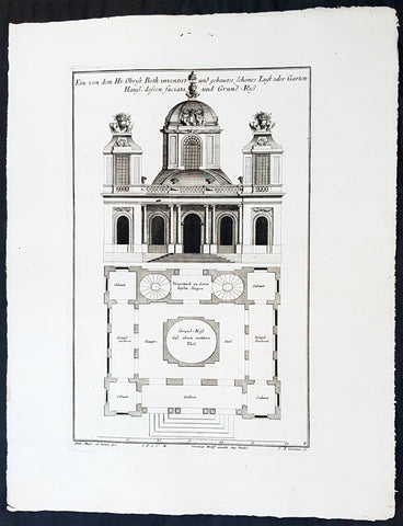
1740 Wolff & Corvinus Antique Architectural Print Charlottenburg Palace, Gardens
- Title : Haupt Hof Grund Riss dess Marstalls...Jeremais Wolff exc Aug. Vind
- Ref #: 93446
- Size: 19in x 12 1/2in (490mm x 335mm)
- Date : 1740
- Condition: (A+) Fine Condition
Description:
This large fine, original copper-plate engraved antique architectural print of buildings in the Charlottenburg suburb of Berlin & Charlottenburg Palace, - plate No. 4 of 16 - by Johann August Corvinus 1683 - 1738, after Andreas Mayers 1716 - 1782, was published in Eigentliche Abbildung des Prächtigen Königl. Lust Schlosses Charlottenburg, eine Meile von Berlin, sambt dem darhinden im Walde gelegenen schönen Lust Garten
(Set of 16 numbered plates, the first with the title, with plans and views of the buildings and gardens at Charlottenburg, the palace of the King of Prussia on the outskirts of Berlin.) by Jeremias Wolff Erben in 1740.
General Definitions:
Paper thickness and quality: - Heavy and stable
Paper color : - off white
Age of map color: -
Colors used: -
General color appearance: -
Paper size: - 19in x 12 1/2in (490mm x 335mm)
Plate size: - 15 1/2in x 10in (385mm x 255mm)
Margins: - Min 1in (25mm)
Imperfections:
Margins: - None
Plate area: - None
Verso: - None
Background:
Charlottenburg is an affluent locality of Berlin within the borough of Charlottenburg-Wilmersdorf. Established as a town in 1705 and named after late Sophia Charlotte of Hanover, Queen consort of Prussia, it is best known for Charlottenburg Palace, the largest surviving royal palace in Berlin, and the adjacent museums.
Charlottenburg is located in Berlins inner city, west of the Großer Tiergarten park. Its historic core, the former village green of Alt Lietzow, is situated on the southern shore of the Spree River running through the Berlin glacial valley. The Straße des 17. Juni road, former Charlottenburger Chaussee, which runs eastwards from Charlottenburg Gate through the Tiergarten park to Brandenburg Gate, connects Charlottenburg with the historic centre of Berlin-Mitte.
In the north and west, the Berlin Ringbahn and the Bundesautobahn 100 (Stadtring) mark the border with the Charlottenburg-Nord and Westend suburbs. Adjacent in the south is the territory of Wilmersdorf. Charlottenburg also borders on the district of Halensee in the southwest, as well as on Moabit, Hansaviertel and Tiergarten (all part of the Mitte borough) in the east and on Schöneberg in the southeast.
In 1695, Sophia Charlotte of Hanover received Lietzow from her husband, Elector Frederick III of Brandenburg, in exchange for her estates in Caputh and Langerwisch near Potsdam. Frederick had a summer residence built there for Sophie Charlotte by the architect Johann Arnold Nering between 1695 and 1699. After he had crowned himself Frederick I, King in Prussia, the Lützenburg castle was extended into a stately building with a cour dhonneur. The Swedish master builder Johann Friedrich Eosander supervised this work. Sophie Charlotte died in February 1705; shortly afterwards the settlement facing the palace was called Charlottenburg - the palace itself became Schloss Charlottenburg - and chartered as a town on April 5, 1705. The king served as the towns mayor until the historic village of Lietzow was incorporated into Charlottenburg in 1720.
Fredericks successor as king, Frederick William I of Prussia, rarely stayed at the palace, which depressed the small town of Charlottenburg. Frederick William even tried to revoke the towns privileges. With the coronation of his successor Frederick II in 1740 the towns significance increased, as regular celebrations again took place at the palace. Between 1740 and 1747 Georg Wenzeslaus von Knobelsdorff built the eastern New Wing as Fredericks residence. Later, Frederick II preferred the palace of Sanssouci, which he had partly designed himself.
When Frederick II died in 1786, his nephew Frederick William II succeeded him, and Charlottenburg became the favourite royal residence, and remained so for his son and successor Frederick William III (reigned 1797-1840). After the defeat of the Prussian army at Jena in 1806, the French occupied Berlin. Napoleon took over the palace, while his troops made a camp nearby. Charlottenburg became part of the new Prussian Province of Brandenburg in 1815 after the Napoleonic Wars.
In the late 18th century, Charlottenburgs development did not depend only on the crown. The town became a recreational area for the expanding city of Berlin. Its first true inn opened in the 1770s, in the street then called Berliner Straße (now Otto-Suhr-Allee), and many other inns and beer gardens were to follow, popular for weekend parties especially. Berliners seeking leisure and entertainment came by boat, by carriage and later by horse-drawn trams, above all to a large amusement park at the shore of the Spree river called Flora, that went into bankruptcy in 1904.
From the 1860s on the wealthy Bourgeoisie of Berlin discovered Charlottenburg as a residential area, among the first were Gerson von Bleichröder and Ernst Werner von Siemens, who had a villa built in the Berliner Straße in 1862. At the same time industrial companies like Siemens & Halske and Schering erected large factories in the north-east, at the border with the Moabit district of Berlin. In 1877 Charlottenburg received town privileges and until World War I saw an enormous increase of population with 100,000 inhabitants as of 1893 and a population of 306,000 in 1920, being the second largest city within the Province of Brandenburg, after Berlin. In the course of industrialization in the 19th century, much of Charlottenburg was incorporated in a network of streets laid out in the Hobrecht-Plan in an area that came to be known architecturally as the Wilhelmine Ring.
Wolff, Jeremais 1663 - 1724
Wolff was an German engraver and publisher. Born in Augsburg, he originally trained as a clock and automat maker, later changing course and opening a small copperplate engraving shop. His success was impressive and became one of the largest European art, print & map publishers in the first half of the 18th century. Wolff employed some of the best engravers of the time and although not an engraver himself, only Wolffs name was recorded on the engravings. Many of his engravers went uncredited for their work. In 1710 Wolff was one of the founder member of the Empire State Academy of Arts in Augsburg.
After his death in 1724, Wolffs publishing business was inherited by his sons and son-in-law, Johann Balthasar Probst (1673–1750) a notable engraver at the time. The firm continued on in Augsburg under the name Jeremias Wolff Erben.
Together with the Nuremberg copperplate engraver Paul Decker , Wolff published a series of engravings showing the war successes of Prince Eugene of Savoy in Italy , southern Germany and the Spanish Netherlands, during the War of the Spanish Succession . The prints are exhibited in the Museum of Military History, in Vienna .
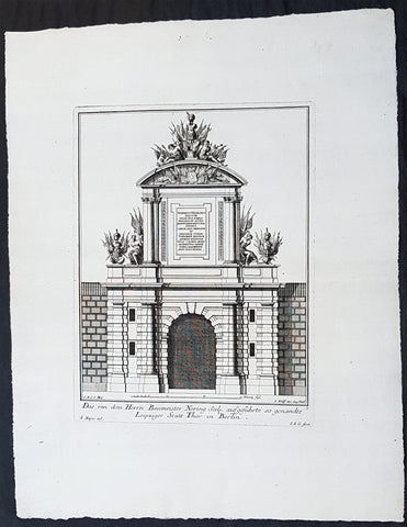
1740 Wolff & Corvinus Antique Architectural Print of Berlin Gate, Leipziger Tor
- Title : Das von dem Herrn Baumeister Nering Seel. ausgefuhrte so genandte Leipziger Statt Thor in Berlin
- Ref #: 93452
- Size: 19in x 12 1/2in (490mm x 335mm)
- Date : 1740
- Condition: (A+) Fine Condition
Description:
This large fine, original copper-plate engraved antique architectural print of buildings & gardens in 17th & 18th century Berlin - plate No. 3 of 16 - by Johann August Corvinus 1683 - 1738, after Andreas Mayers 1716 - 1782, was published in Eigentliche Abbildung des Prächtigen Königl. Lust Schlosses Charlottenburg, eine Meile von Berlin, sambt dem darhinden im Walde gelegenen schönen Lust Garten
(Set of 16 numbered plates, the first with the title, with plans and views of the buildings and gardens at Charlottenburg, the palace of the King of Prussia on the outskirts of Berlin.) by Jeremias Wolff Erben in 1740.
General Definitions:
Paper thickness and quality: - Heavy and stable
Paper color : - off white
Age of map color: -
Colors used: -
General color appearance: -
Paper size: - 19in x 12 1/2in (490mm x 335mm)
Plate size: - 14 1/2in x 10 1/2in (370mm x 260mm)
Margins: - Min 1in (25mm)
Imperfections:
Margins: - None
Plate area: - None
Verso: - None
Background:
Berlin straddles the banks of the River Spree, which flows into the River Havel (a tributary of the River Elbe) in the western borough of Spandau. Among the citys main topographical features are the many lakes in the western and southeastern boroughs formed by the Spree, Havel, and Dahme rivers (the largest of which is Lake Müggelsee). Due to its location in the European Plain, Berlin is influenced by a temperate seasonal climate. About one-third of the citys area is composed of forests, parks, gardens, rivers, canals and lakes. The city lies in the Central German dialect area, the Berlin dialect being a variant of the Lusatian-New Marchian dialects.
First documented in the 13th century and situated at the crossing of two important historic trade routes, Berlin became the capital of the Margraviate of Brandenburg (1417–1701), the Kingdom of Prussia (1701–1918), the German Empire (1871–1918), the Weimar Republic (1919–1933), and the Third Reich (1933–1945). Berlin in the 1920s was the third-largest municipality in the world. After World War II and its subsequent occupation by the victorious countries, the city was divided; West Berlin became a de facto West German exclave, surrounded by the Berlin Wall (1961–1989) and East German territory. East Berlin was declared capital of East Germany, while Bonn became the West German capital. Following German reunification in 1990, Berlin once again became the capital of all of Germany.
The Thirty Years War between 1618 and 1648 devastated Berlin. One third of its houses were damaged or destroyed, and the city lost half of its population. Frederick William, known as the Great Elector, who had succeeded his father George William as ruler in 1640, initiated a policy of promoting immigration and religious tolerance. With the Edict of Potsdam in 1685, Frederick William offered asylum to the French Huguenots.
By 1700, approximately 30 percent of Berlins residents were French, because of the Huguenot immigration. Many other immigrants came from Bohemia, Poland, and Salzburg.
Since 1618, the Margraviate of Brandenburg had been in personal union with the Duchy of Prussia. In 1701, the dual state formed the Kingdom of Prussia, as Frederick III, Elector of Brandenburg, crowned himself as king Frederick I in Prussia. Berlin became the capital of the new Kingdom, replacing Königsberg. This was a successful attempt to centralise the capital in the very far-flung state, and it was the first time the city began to grow. In 1709, Berlin merged with the four cities of Cölln, Friedrichswerder, Friedrichstadt and Dorotheenstadt under the name Berlin, Haupt- und Residenzstadt Berlin.
In 1740, Frederick II, known as Frederick the Great (1740–1786), came to power. Under the rule of Frederick II, Berlin became a center of the Enlightenment, but also, was briefly occupied during the Seven Years War by the Russian army. Following Frances victory in the War of the Fourth Coalition, Napoleon Bonaparte marched into Berlin in 1806, but granted self-government to the city. In 1815, the city became part of the new Province of Brandenburg.
The Industrial Revolution transformed Berlin during the 19th century; the citys economy and population expanded dramatically, and it became the main railway hub and economic centre of Germany. Additional suburbs soon developed and increased the area and population of Berlin. In 1861, neighbouring suburbs including Wedding, Moabit and several others were incorporated into Berlin. In 1871, Berlin became capital of the newly founded German Empire. In 1881, it became a city district separate from Brandenburg.
Wolff, Jeremais 1663 - 1724
Wolff was an German engraver and publisher. Born in Augsburg, he originally trained as a clock and automat maker, later changing course and opening a small copperplate engraving shop. His success was impressive and became one of the largest European art, print & map publishers in the first half of the 18th century. Wolff employed some of the best engravers of the time and although not an engraver himself, only Wolffs name was recorded on the engravings. Many of his engravers went uncredited for their work. In 1710 Wolff was one of the founder member of the Empire State Academy of Arts in Augsburg.
After his death in 1724, Wolffs publishing business was inherited by his sons and son-in-law, Johann Balthasar Probst (1673–1750) a notable engraver at the time. The firm continued on in Augsburg under the name Jeremias Wolff Erben.
Together with the Nuremberg copperplate engraver Paul Decker , Wolff published a series of engravings showing the war successes of Prince Eugene of Savoy in Italy , southern Germany and the Spanish Netherlands, during the War of the Spanish Succession . The prints are exhibited in the Museum of Military History, in Vienna .